
From collection Jesup Library Maine Vertical File

Page 1
Page 2
Search
results in pages
Isle Au Haut map & brochure
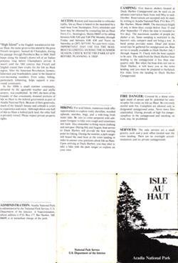
CAMPING: Five lean-to shelters located at
Duck Harbor Campground can be used on an
advance reservation basis from mid-May to mid-
October. Reservations are accepted only by mail,
ACCESS: Remote and inaccessible to vehicular
by writing to Acadia National Park, P.O. Box 177,
traffic, Isle au Haut is linked to the mainland by a
Bar Harbor, Maine 04609. The maximum length
mail boat from Stonington. Ferry schedules and
of stay is three days, except before June 15 and
fares may be obtained by contacting Isle au Haut
after September 15 when the time is extended to
Ferry Co., Stonington, Maine 04645 or by calling
five days. The maximum number of people per
between 8:00 AM and 5:00 PM Monday through
shelter is six. Since camping is restricted to the
Friday and between 8:00 AM and Noon on
lean-to's only, campers need not bring a tent. A
"High Island" is the English translation for Isle
Saturday at (207) 367-5193. No auto ferry exists.
hand pump provides water. Dead and down
au Haut, the name given to this island by the great
IMPORTANT: DAY USE VIA THE MAIL
wood may be gathered for campground use. Boat
French navigator, Samuel de Champlain, during
BOAT IS LIMITED. DURING THE SUMMER
service is usually available to Duck Harbor July 1
his passage through Penobscot Bay in 1604. Shell
SEASON, CHECK WITH THE PARK STAFF
through August 31. Check with the boat captain
BEFORE PLANNING A TRIP.
heaps along the Island's shores tell of an Indian
to be sure. The walk from the Duck Harbor boat
presence long before Champlain's arrival. It
landing to the campground is less than one-
wasn't until the 18th centruy that French and
quarter mile. But when the boat does not run to
English ceased their rivalry for the Isle au Haut
Duck Harbor, it will leave you at the town
region. After the American Revolution, farmers,
landing, and you must be prepared to backpack
fishermen and boatbuilders came to the Island in
five miles from the landing to Duck Harbor
ever-increasing numbers. Even today, fishing,
Campground.
particularly lobstering, helps support a year-
round community.
In the 1880s a small summer community,
attracted by the agreeable weather and idyllic
scenery, was established. In 1943, the heirs of the
founder of that community donated portions of
FIRE DANGER: Covered by a dense even-
Isle au Haut to the federal government as part of
aged stand of spruce and fir, potential for cata-
Acadia National Park. Because of their generosity,
strophic fire exists on Isle au Haut. Be extremely
much of the Island's beauty and solitude is yours
HIKING: For avid hikers, numerous trails offer
careful with fire. Campfires are allowed only in
to experience and enjoy. Although about one-half
designated campground areas. Never leave fires
of Isle au Haut is federal park land, the other half
opportunities to explore rocky shoreline, wooded
unattended. During periods of high fire danger,
is privately owned. Please respect private property
uplands, marshes, bogs, and a mile-long fresh
campfires in the campground and smoking on
rights.
water lake. Be sure to come prepared with ade-
trails may be prohibited.
quate footgear to hike over rough and sometimes
wet trails. Also remember to bring warm clothing
and rain gear. During July and August, boat service
to Duck Harbor will provide the best starting
SERVICES: The only services are a small
point for hiking. During the summer, a park ranger
grocery store and a post office located near the
will board the mail boat at the town landing in
town landing. There are no overnight accom-
order to answer your questions about Isle au Haut.
modations and no private campgrounds.
Upon arriving at Duck Harbor, you may elect to
take a hike with the park ranger or explore on
your own.
ISLE
AU
HAUT
ADMINISTRATION Acadia National Park
is administered by the National Park Service, U.S.
Department of the Interior. A Superintendent,
whose address is P.O. Box 177, Bar Harbor, ME
04609, is in immediate charge of the park.
National Park Service
U.S. Department of the Interior
Acadia National Park
100
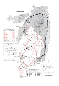
ISLE AU HAUT
Coombs Mt.
100
200
Kimball
HAUT THOROFARE
TOWN
LANDING
Island
ISLE AU
100
RANGER
004
STATION
100
Mt. Champlain
00€
Robinson Point
Lighthouse
Sawyer Mt
TRAIL INFORMATION
NAME
DISTANCE
TIME
(miles)
HARBOR
BOWDITCH
300
2.0
1.6 hours
CLIFF
0.7
45 minutes
DEEP COVE
0.2
5 minutes
DUCK
DUCK HARBOR
3.8
2 hours
Jerusalem Mt.
DUCK HARBOR MT.
1.2
1.5 hours
EBEN'S HEAD
0.8
ADITCH
30 minutes
ELI'S CREEK
0.2
5 minutes
TO
GOAT
2.1
1.25 hours
AOO
LONG POND
3.0
2 hours
MEDIAN RIDGE
1.8
1 hour
00z
NAT MERCHANT
1.1
45 minutes
TREAT
WESTERN HEAD
1.3
1.25 hours
5.0
Seal Trap
Moore's Harbor
PAVED ROAD
UNPAVED ROAD
7.0
WESTERN HEAD ROAD 1.7
25 minutes
IELIS
Bowditch Mt.
LONG
DUCK HARBOR CAMPGROUND & VICINITY
TRAIL
LONG
200
Deep
Cove
DEEP
POND
TRAIL
LONG
COVE
100
TRAIL
Wentworth Mt.
DUCK
HARBOR
dock
4
HEAD
HARBOR
100
01
WESTERN
000
00
KEY
HEAD
1
campsite
1
toilet
0
1/8
1/4
IEBEN'S
RIDGE
water
miles
DUCK HARBOR ANDING
-A-
NOTE: After rain, marshes along Bowditch Trail
and Goat Trail may be too wet for hiking. Ask
a ranger for current trail conditions.
D
Opuck Harbor Mt.
MEDIAN
100
Merchant
Cove
MT.
Head Harbor
N
TRAIL
TRAIL
-
Barred
Harbor
Eastern
100
Squeaker
Head)
Cove
Eastern
Ear
Deep
Western
Cove
Head
Thunder
Please respect private property rights.
Gulch
TRAIL
KEY
hiking trail
park land
0
1/2
1
CLIFF
limited access road
private land
miles
unpaved road
park boundary
paved road
campground
lake
picnic table
contour Interval 100 feet
1
marsh
Western Ear
Viewer Controls
Toggle Page Navigator
P
Toggle Hotspots
H
Toggle Readerview
V
Toggle Search Bar
S
Toggle Viewer Info
I
Toggle Metadata
M
Zoom-In
+
Zoom-Out
-
Re-Center Document
Previous Page
←
Next Page
→
Isle Au Haut map & brochure
Information on Access, Hiking, Camping, Fire Danger, Services, Administration
Details
Acadia National Park (unspecified feature), Hancock and Knox Counties, ME
Isle au Haut (island), Penobscot Bay, Isle au Haut, Knox County,ME
Isle au Haut (island), Penobscot Bay, Isle au Haut, Knox County,ME
11 x 17 inches
Folded brochure
yellowed with some fingerprint stains

