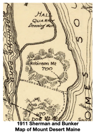
The section of the Acadia Mountain Trail from the summit down to the east end of Man of War Brook Trail is shown on an 1896 Mount Desert Path map and on the 1911 Sherman and Bunker map of Mount Desert. This end of the Acadia Mountain trail is located near the former homestead of Mr. Henry Robinson. “Mr. Robinson owned 40 acres of land fronting on Somes Sound, built a house and lived there for many years. The house was burned. In his later years he became obsessed with the idea that Capt. Kidd, the pirate, had hidden great treasure on his land and he spent much time in digging for it and excavated a great cave in the mountain, but found no treasure” ( Mrs. Seth S. Thornton, "Traditions and Records Southwest Harbor and Somesville, Mount Desert Island, Maine 1938, p. 127). The road leading to his homestead is the present day Man O War Brook Trail (#130).
Benjamin Franklin DaCosta wrote about his visit to the Robinson homestead in his 1871 guide book,
Rambles In Mount Desert. DeCosta sailed up Somes Sound to the landing at the Man O War Brook, the same location as the Acadia Mountain Trail overlook spur. He described the area, “The bank is of shelving granite, down which pours a small stream known as Man-Of-War Brook… On one side of the brook was a landing, and a couple of wild, amphibious looking boys were pushing out in a weather-beaten boat with an old black sail… Two little girls, with bare heads and feet, sat on the bank… Their parents lived in a log house up in the valley…we inquired where the (gold-diggers) were at work…a short walk (up the valley).... In the middle of the cleared ground was an excavation large enough for the cellar of a good sized house…a couple of strange looking men were hard at work with long handled spades…these were the money-diggers” (Benjamin DeCosta,
Rambles in Mount Desert,1871,
https://www.canadiana.ca/view/oocihm.06016/10 ).
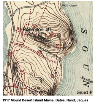
In the 1915 Seal Harbor Village Improvement Society (SHVIS) 15th Annual Report, Joseph Allen, Chairman of the Seal Harbor VIS described the trail on Robinson Mountain, (the former name for Acadia Mountain), as a new trail. Mr. Allen attributed this trail work to Mr. Buell and his committee from Southwest Harbor. The Acadia Mountain Trail as marked today comprises three formerly separate trails described in the 1915 path guide, and shown on the 1917 Path map, namely “The Somesville Road trail” (#39), “The Robinson Mountain trail” (#37), and “The Tug Of War Trail” (#36).
On the 1942 Acadia National Park topographic map, four other trails coming from the Hall Quarry Road connected to the Acadia Mountain Trail creating a more extensive network of trails than the present day system. Those connecting trails ran through multiple quarrying operations on the north and west side of Acadia Mountain.
Some time in the 1960s the Acadia Mountain trail was slightly rerouted away from the three geodetic Robinson Mountain markers located at the eastern side of the mountain ridge. Extensive repairs by the Acadia National Park trails crew in 2003 and 2016 added 218 stone steps and new retaining walls.


