
From collection Place

Related Items

Blue Hill
Village of Blue Hill; copy Shows houses with names and names of major streets.
Plot plan of Rev. Fisher's house
Photocopy of a plan drawn by Jonathan Fisher that shows the house, outbuildings gardens, apple orchard, etc.
Two Hundred Years Plus Ten The First congregational Church of Blue Hill Maine
Pamphlet. "Two Hundred Years Plus Ten". History of the First Congregational Church of Blue Hill, Maine.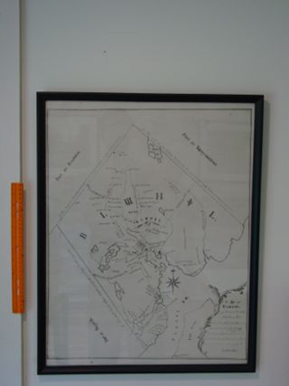
Map of Blue Hill Maine
Print, "Map of Bluehill" - 1794. 19 1/2 by 25 inches in black frame (20 1/2 x 26 in.). Fisher wrote some of the map in his shorthand. Original by Jonathan Fisher is in the Farnsworth. Print from the original at the William A. Farnsworth Li…
Blue Hill Maine
Copy of Blue Hill with names and of people,, stores listed, etc.
Blue Hill Maine
Print, "Map of Bluehill, 1794" by Jonathan Fisher 19 1/2 x 25 inches.
Key to A Morning View of Bluehill painted by Jonathan Fisher in 1824
Black & white; 12 x 16; has the names of houses & other buildings.
Blue Hill map
Black and white photocopy of a map of Blue Hill drawn by Jonathan Fisher. Approximately 11 x 13 1/2 inches.
Map of Blue Hill Maine
The map is not to scale. It contains some of the buildings appearing in the Jonathan Fisher painting of Blue Hill in 1824. Has initials RKS at the bottom.

