
From collection Jesup Library JDR Jr. Collection

Page 1
Page 2
Page 3
Page 4
Page 5
Page 6
Page 7
Page 8
Page 9
Page 10
Page 11
Page 12
Page 13
Page 14
Page 15
Page 16
Page 17
Page 18
Page 19
Page 20
Page 21
Page 22
Page 23
Page 24
Page 25
Page 26
Page 27
Page 28
Page 29
Page 30
Page 31
Page 32
Page 33
Page 34
Page 35
Page 36
Page 37
Page 38
Page 39
Page 40
Page 41
Page 42
Page 43
Page 44
Page 45
Page 46
Page 47
Page 48
Page 49
Page 50
Page 51
Page 52
Page 53
Page 54
Page 55
Page 56
Page 57
Page 58
Search
results in pages
Marcyes. Sherman & Roberts Green Mt.
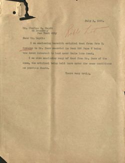
July 1, 1925.
Mr. Charles O. Heydt
26 Broadway
New York City
Rost hot
Dear Mr. Heydt:
I am enclosing herewith original deed from John H.
Sprague to Mr. Dorr recorded in Book 595 Page 7 being
his dower interest in land near Eagle Lake Road.
I am also enclosing copy of deed from Mr. Dorr of the
same, the original being held here under the same conditions
as previous deeds.
Yours very truly,
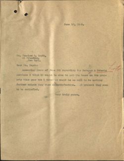
June 10, 1925.
Mr. Charles Oo Heydt,
26 Broadway,
New York.
Dear Mr. Heydt:
Answering yours of June 5th regarding the Marayes & Roberts
Lote
purchase I think it would be wise to pay the taxes on the prop-
erty this year but I thin it would be as well to do nothing
further unless they show dissatisfaction. At present they seem
to be satisfied.
Very truly yours,
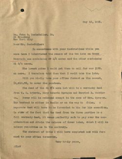
May 13, 1925.
Mr. John D. Rockefeller, Jr.
26 Broadway
New York City
DearMMr. Rockefeller:
In accordance with your instructions while you
were here I interviewed the owners of the two lots on Green
Mountain one containing 27 1/2 acres and the other containing
21 3/4 acres.
The lowest price I could get them to sell for was $175.
an acre. I therefore told them that I would take the lots.
will you kindly have your office forward me the amount,
$8,618.75, to cover the purchase.
The deed of the 21 3/4 acre lot will be a warranty deed
from T. Is Roberts, Mary Roberts Sprague and Harriet R. Morris-
on.
Dower will be released except in the case of Mrs. Sprague.
Her husband is either in Manila or on the way to China. A
separate deed will have to be forwarded to him for his execution.
In view of the fact that the deed from the three parties is a
full warranty deed, it seems perfectly safe to pay over the con-
sideration and obtain the release of dower later, which I will do
unless you advise me to the contrary.
The abstract of title I will have completed and will for-
ward to your office to-morrow.
Very truly yours,
AHL:G
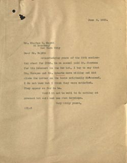
June 2, 1925.
Mr. Charles 0. Heydt
26 Broadway
New York City
Dear Mr. Heydt:
Acknowledging yours of the 29th enclos-
ing check for $385. in re amount paid Mr. Sherman
for his interest in the How lot, I beg to say that
Mr. Marcyes and Mr. Roberts were willing and did
close the matter on the basis originally discussed.
I do not know but I think they were satisfied.
They appear so far to be.
Would it not be well to do nothing at
present but wait and see what develops.
Very truly yours,
AHL:G
26 Broadway
New York
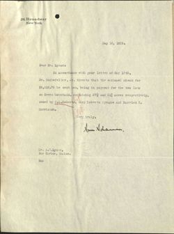
May 18, 1925.
Dear Mr. Lynam:
In accordance with your letter of May 13 th,
Mr. Rockefeller, Jr. directs that the enclosed check for
$8,618.75 be sent you, being in payment for the two lots
on Green Mountain, containing 271/2018 and 212 acres respectively,
owned by T.L.Roberts, Mary Roberts Sprague and Harriet R.
Morrisson.
Very truly,
Non Adam
Mr. A.H.Lynam,
Bar Harbor, Maine.
Enc
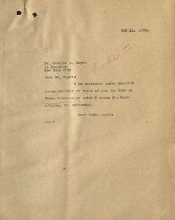
May 14, 1925.
Mr. Charles 0. Heydt
26 Broadway
New York City
Dear Mr. Heydt:
I am enclosing under separate
cover abstract of title of the two lots on
Green Mountain of which I wrote Mr. Rock-
efeller, Jr. yesterday.
Very truly yours,
AHL:G
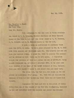
May 26, 1925.
Mr. Charles 0. Heydt
26nBroadway
New York City
Dear Mr. Heydt:
with reference to the two lots on Green Mountain
one owned by T. I. Roberts, Harriet Morrison and Mary Sprague
known as the Roberts lot and the other owned by W. H. Sherman,
W. M. Roberts and C. E. Mareyes known as the How lot.
I made a trade as authorized to purchase these
lots for $175. an acre. We had a plan prepared by Mr. E. W. Hill
with full courses and di stances upon it. The Roberts lot did not
have the acreage shown. I asked Mr. Hill to compute the acreage
and he advised me that there was 21 3/4 acres. I therefore
closed the purchase of this lot paying the sum of $3806.25, being
amount forwarded me, of which I retained $396. to be paid over
unon receipt of the deed of the dower interest of Mrs. Sprague.
This you will recall I spoke to you about when you were here.
The other lot, the How lot, was shown on the old
sketch as containing 27.5 acres. Mr. Hill did not compute the
acreage of this lot but he did say that there was at least that
amount.
I repared the deed and was on the point of taking
title when one of the owners of the How lot, Mr.Sherman, declared
he was not satisfied with the acreage and wanted the figures
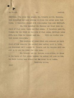
Mr. C.O.H.
-2-
5-26-25
verified. The other two owners, Mr. Roberts and Mr. Marcyes,
were satisfied and were willing to close the matter upon that
basis. I therefore closed with them paying them each $1604.17.
Mr. Hill verified the figures and found that in-
stead of 27.5 acres there was 34.1 acres. I therefore paid Mr.
Sherman for his third at the rate of 34.1 acres, $1989.16 being
$385. more than the amount sent me.
Will you kindly have
that amount forwarded.
The question of taxes which are assessed on April
first of the year, for the current year ending April 1, 1926,
was discussed and I expect Mr. Roberts and Mr. Moreyes will ex-
pect us to pay the taxes for this year.
Mr. Roberts and Mr. Marcyes were willing to close
on the basis of 27.5 acres because the matter had gone so far,
the deeds having been signed and the money in my hands.
Verytruly yours,
AHL:G
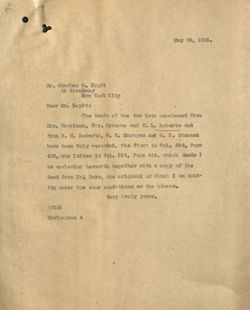
May 29, 1925.
Mr. Charles O. Heydt
26 Broadway
New York City
Dear Mr. Heydt:
The deeds of the two lots purchased from
Mrs. Morrison, Mrs. Sprague and T. L. Roberts and
from W. M. Roberts, C. E. Mareyes and W. H. Sherman
have been duly recorded, the first in Vol. 594, Page
425,athe letter in Vol. 594, Page 424, which deeds I
am enclosing herewith together with a copy of the
deed from Mr. Dorr, the original of which I am hold-
ing under the same conditions as the others.
Very truly yours,
AHL:G
Enclosures 4
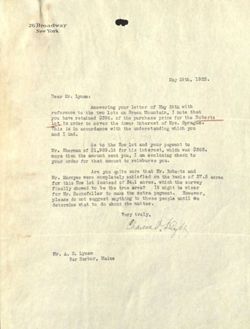
26 Broadway
New York
May 29th, 1925.
Dear Mr. Lynam:
Answering your letter of May 26th with
reference to the two lots on Green Mountain, I note that
you have retained $396. of the purchase price for the Roberts
lot in order to cover the dower interest of Mrs. Sprague.
This is in accordance with the understanding which you
and I had.
As to the How lot and your payment to
Mr. Sherman of $1,989.16 for his interest, which was $385.
more than the amount sent you, I am enclosing check to
your order for that amount to reimburse you.
Are you quite sure that Mr. Roberts and
Mr. Marcyes were completely satisfied on the basis of 27.5 acres
for this How lot instead of 34.1 acres, which the survey
finally showed to be the true area?
It
might
be
wiser
for Mr. Rockefeller to make the extra payment. However,
please do not suggest anything to these people until we
determine what to do about the matter.
Very truly,
Mr. A. H. Lynam
Bar Harbor, Maine
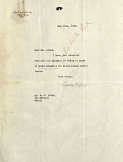
26 Broadway
New York
May 16th, 1925.
Dear Mr. Lynam:
I have just received
from you the Abstract of Title to lands
on Green Mountain for which please accept
thanks.
Very truly,
Mr. A. H. Lynam,
Bar Harbor,
Maine.
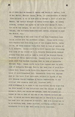
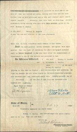
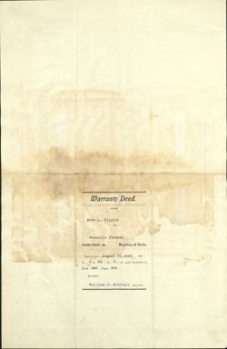
BE IT KNOW That we Norman F. Beaton and Nellie E. Beaton, both
of Bar Harbor, Hancock County, Maine, in consideration of twenty-
five dollars, to us in hand paid by George B. Dorr of said Bar
Harbor, the receipt whereof is hereby acknowledged, do hereby
promise, covenant and agree to and with said George B. Dorr,
his heirs and assigns, to sell and convey to him, his heirs and
assigns, the following described real estate, situated in said
Bar Harbor, Viz.:
Beginning on the side line of the Amos Richardson home
lot so called near the northwest corner; thence north forty-
five degrees west following land of the Bingham Estate, being
lot No. 49 three hundred forty-five feet to land of estate of
T. L. Roberts; the nce south forty-five degrees west following
said land of the estate of T. L. Roberts twenty-seven hundred
seventy-four feet more or less to land of the Hancock County
Trustees of Public Reservations; thence south forty-five de-
grees east four hundred fourteen feet to land of Lafayette
National Park; thence north forty-five degrees east by said
land of Lafayette National Park to the head line of said Rich-
ardson Lot; thence north forty-five degrees west to the corner
bound of said Richardson Lot; theneenorth forty-five degrees
east to the bound first mentioned, subject to rights of the
said Hancock County Trustees of Public Reservations in the
carriage road crossing said lot. (courses 1837)
Said conveyance to be made at any time within thirty days from
the date hereof, at the option and upon the request of said
George B. Dorr, his heirs and assigns, upon the payment or
tender by him or them of the sum of two hundred dollars per
acre, of which the above mentioned sum of twenty-fi dollars
has been paid and received on account; and said conveyance to
be by warranty deed, dower released, conveying perfect and un-
encumbered title to the real estate above described.
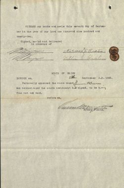
WITNESS our hands and seals this seventh day of Septem-
ber in the year of our Lord one thousand nine hundred and
twenty-two.
Signed, sealed and delivered
in presence of
2
nelli E Beatour
STATE OF MAINE
HANCOCK ss.
8th September A.D. 1922.
.
Personally appeared the above name d
and ac knowl edged the above instrument his signed, to be his
free act and deed.
Before me,
Notary Public.
Beaton
Jass:
[No. 102.]
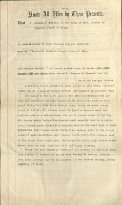
know All Men by These Presents,
That
I, Norman F. Beaton, of the Town of Eden, County of
Hancock, State of Maine,
in consideration of nine hundred dollars ($900.00)
paid by Vernon G. Wasgatt of said Town of Eden,
the receipt whereof I do hereby acknowledge, do hereby give, grant,
bargain, sell and convey unto the said Vernon G. Wasgatt and his
Heirs and Assigns forever,
A certain lot or parcel of land, lying in said Eden, numbered
Fifty-six on a plan of Peters survey, and bounded as follows, viz:
Beginning on the side line of the Amos Richardson home lot
near the northwest corner; thence north forty-five degrees west
about sixty-five rods to a hemlock tree, being the east corner
bound of lot No. 53; thence south forty-five degrees west two
hundred rods to a spruce tree, the north corner bound of Lot No.
57; thence south forty-five degrees east seventy rods to a spruce
tree; thence north forty-five degrees east to the head line of said
Richardson lot; thence north forty-five degrees west to the corner
bound of said Richardson Lot; thence north forty-five degrees east
to the bound first mentioned, the whole lot containing eighty-seven
acres, more or less, together with buildings thereon.
Being the same premises described as conveyed in the deed from
said Vernon G. Wasgatt to me the said Norman F. Beaton, bearing
even date herewith and to be recorded in the Hancock County, Maine,
Registry of Deeds.
To have and to bold the aforegranted and bargained
premises, with all the privileges and appurtenances thereof to the
said Vernon G. Wasgatt and his
Heirs and Assigns, to his and their use and behoof forever.
And I do covenant, with the said Grantee , his Heirs
and Assigns, that I am lawfully seized in fee of the premises;
that they are free of all incumbrances;
that I have good right to sell and convey the same to the said
Grantee
to hold as aforesaid; and that I and my heirs, shall
and
will Warrant and Defend the same to the said
Vernon G. Wasgatt and his
Heirs and Assigns forever against the lawful claims and demands of
all persons.
Provided Nevertheless, that if the said
Norman F. Beaton, or his
Heirs, Executors or Administrators pay to the said
Vernon G. Wasgatt, or his
CPS
Heirs, Executors, Administrators or Assigns, the sum of
Nine hundred dollars, in payments as follows: $200 on September
1, 1918, ;$200 on September 1, 1919; $200 on September 1, 1920;
$200 on September 1, 1921; and $100 on September 1, 1922;
with interest on said sum at the
rate of six per centum per annum, during said term and for such
further time as said principal sum or any part thereof shall remain
unpaid, payable
annually, then this Deed, as also five certain
promissory notes bearing even date with these presents, given by the
said Norman F. Beaton
to the said
Vernon G. Wasgatt
to pay the sum and interest at the time aforesaid,
shall all be void, otherwise shall remain in full force.
And the said grantor hereby covenant and agree with said
grantee that the right of redeeming the above mortgaged premises
shall be forever foreclosed in one year next after the commencement of
foreclosure by any of the methods now provided by law.
In Witness Whereof,
I
the said
Norman F. Beaton
and
I, Elizabeth H. Beaton
wife
of the said
Norman F. Beaton
joining in this deed as Grantor , and relinquishing and conveying my
right by descent and all other rights in the above described premises,
have hereunto set our hand S and seals this twenty-seventh day of
February
in the year of our Lord one thousand nine
hundred and eighteen.
Signed, Sealed and Delivered
in Presence of
a.H.Rynam
Norman Beston
Ebhitt Beatun
State of Maine,
ss.
Ha ne ock
Feb. 27
19018
Personally appeared the above named
Norman F. Beaton and acknowledged the above instru-
ment to be his free act and deed.
Before me,
albert Holynam
Peacex
Notary Public
P#7-
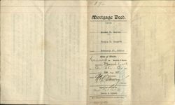
Mortgage Deed.
when
FROM
E
I
D
Norman F. Beaton
TO
Vernon G. Wasgatt
Dated
February 27, 1918190
Loancoch State ss. Maine. "Registry of
of
Deeds.
Received March 1, 19/8.
at
12 H., 25 M., P
TIM.
and
recorded in Book 538 Page
of
Attest: Register.
FROM THE OFFICE OF
Ried is t Ref
Deasy & Lynam
W. H. Sherman, Printer and Stationer, Bar Harbor, Maine,
1-1225-X-80
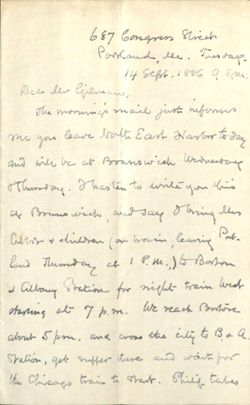
687 Congress Street
Passand lee. Therady
14 Sept. 1886 a am
Dear lew Gieman,
The morning's mail just informs
me you leave both East Nasbor today
and will be at Branswich underwrate
Thursday Hasten to write you his
as Brunswich , and say gling this
Cibrar & diverse (on Train learning Pat-
land Thursday at / P.M. ) to Borton
d albany Station for night train wed
staring at 7 p.m. We reach Borton
about 5pm. and cross the city to Bd a.
Station, get suffer there and wait for
the Chicago train to start. Shill takes
the family lost, & I remain East for a few days. If ym
go to New york Thursday might oshall Crope to see you
at
Brunswirlo, whether twile go as soon as the about : train
leaves for west, as the NEWYon trains do nor start until
about 10 p. m. or later. 2 and sorry that otherwise I
,
Shale miss seeing you this time " ofear. My Borboin
office is "Room " 81, No.50 'States Street, (so Box 1151) which is a
"
permanent address as much as ; but absence
from Eithin delays mail which is then forwarded. write
Kind rementrance to you are hum faithfully
Eroni H. aver
weic,
antral
Penokee
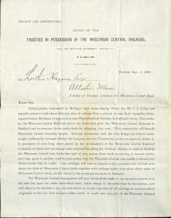
PRIVATE AND CONFIDENTIAL.
OFFICE OF THE
TRUSTEES IN POSSESSION OF THE WISCONSIN CENTRAL RAILROAD,
NO. 50 STATE STREET ROOM 81.
P. O. Box 1151.
To Luck Hanna Eyes
BOSTON, Sept. I, 1886.
allston Mass
A holder of Trustees' Certificate for Wisconsin Central Stock.
DEAR SIR:
Certain parties interested in Michigan iron mines (among whom are Mr. C. L. Colby and
myself) intend to build about fifty (50) miles of railroad from a point at or near Lake Agogebic, Onto-
nagon County, Michigan, to a point at or near Winnebosho or Penokee, in Ashland County, Wisconsin,
on the Wisconsin Central Railroad, and to use from that point the Wisconsin Central Railroad to
Ashland, and to construct there costly docks for shipping iron ores. This construction will benefit
Wisconsin Central interests largely. Railroad connection with the Iron Range has hitherto been
sought ineffectually, because neither the Company nor the Trustees had power or means to obtain it.
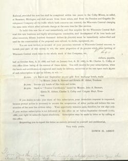
In pursuance of votes long since passed by the stockholders of the Wisconsin Central Railroad
Company to induce and encourage such construction along the Penokee Range, in order to develop
the Wisconsin Central iron lands, free right of way across those lands (reserving all mineral rights,
etc.) was given to another road to some extent, but the Wisconsin Central was unable to secure any
direct benefit from its traffic. Like privileges will now be granted to the proposed new railroad over
about ten miles of Wisconsin Central lands, together with trackage rights over about thirty miles of
Wisconsin Central track, on fair terms, to the proposed ore-docks at Ashland.
The Wisconsin Central management will also throw all the traffic it can hereafter control over
the new line, upon the same rates which other roads charge at the same time for like service, and
will allow to the new line a ten per cent rebate on its pro rata share of all earnings on business which
originates on the new line and goes either north or south over any part of the Wisconsin Central
Railroad, provided the new line shall be completed within two years to the Colby Mines, so called,
at Bessemer, Michigan, and shall secure from those mines, and from the Penokee and Gogebic De.
velopment Company all the traffic which both concerns can control, the Wisconsin Central charging
the same rates which other railroads charge at the same time for like services.
To build this new line of road immediately, and thus acquire for the Wisconsin Central Rail-
road this new business and highly advantageous connection, and development of its iron lands and
other resources, fifteen hundred thousand dollars ($1,500,000) must be immediately subscribed and
used for the construction of the proposed new railroad, its docks, equipment, etc.
You are now invited, on account of your pecuniary interest in Wisconsin Central success, to
furnish your part of this money, to wit, the same proportion of $1,500,000 which your holding of
B 600
Wisconsin Central stock bears to the whole stock of that Company, viz.,
dollars, payable,
half on October first, A. D. 1886, and half on January first, A. D. 1887, to Mr. Charles L. Colby, at
this office (time being of the essence of these dates). You will receive for your subscription, when
the bonds and certificates are engraved and ready for delivery, securities at the rate upon each $5,000
of cash subscription so paid as follows, to wit:
$5,000. 5% March and September 50-year gold first mortgage bonds, made
to Messrs. John A. Stewart and Edwin H. Abbot, Trustees.
$1,000. Income 5% bonds of like form and terms.
$2,500. Stock in "Trustee Certificates," issued by Messrs. John A. Stewart,
Edwin H. Abbot, Charles L. Colby and Colgate Hoyt, Trus-
tees.
If you desire to take your share of this subscription, your immediate response is requested,
because prompt action is necessary to secure the co-operation of other parties and induce the con-
struction of the new line without delay. Your opportunity remains open, therefore, for ten days only.
If your written subscription is not delivered at this office on or before September eleventh (11th),
1886, your right to subscribe lapses absolutely. Subscription may be made by letter or by calling at
this office.
Requesting you to regard this letter as entirely personal to yourself and confidential,
Very truly yours,
EDWIN H. ABBOT.
I Sim You this Copy chi Circular which mill fire
clea. I have no Extra Collins
of you the
Y2Spmin
D
127
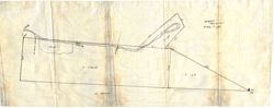
W.GHill
May/21921
Bridge
scale /"= 100'
Woods
Beach Tree
ii
R
A=6.22A
594
A=1.6A
Cor
N. Beator
5A.
ISB
Roberts
Nat'l Park
S.B.
SB
551-30'W 404'
BEATON
1.0 Acre
BOAR
3
r
GREEN
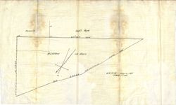
W.G.Hill May 12 1921
5 sale 1"=40"
OLD
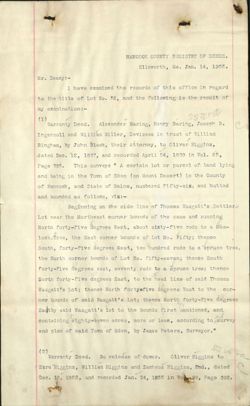
HANCOCK COUNTY REGISTRY OF DEEDS.
Ellsworth, Me. Jan. 14, 1905.
Mr. Deasy:-
I have examined the records of this office in regard
to the title of Lot No. 56, and the following is the result of
my examination:
(1)
ssura
Warranty Deed. Alexander Baring, Henry Baring, Joseph R.
Ingersoll and William Miller, Devisees in trust of William
Bingham, by John Black, their Attorney, to Oliver Higgins,
dated Dec. 12, 1837, and recorded April 24, 1838 in Vol. 65,
Page 388. This conveys " A certain lot or parcel of land lying
and being in the Town of Eden (on Mount Desert) in the County
of Hancock, and State of Maine, numbered fifty-siz, and butted
and bounded as follows, viz:-
Beginning on the side line of Thomas Wasgatt's Settler's
Lot near the Northwest corner bounds of the same and running
North forty-five degrees West, about sixty-five rods to a Hem-
lock Tree, the East corner bounds of Lot No. Fifty; thence
South, forty-five degrees West, two hundred rods to a spruce tree,
the North corner bounds of Lot No. fifty-seven; thence South
forty-five degrees east, seventy rods to a spruce tree; thence
North forty-five degrees East, to the head line of said Thomas
Wasgatt's Lot; thence North fortysfive degrees West to the cor-
ner bounds of said Wasgatt's Lot; thence North forty-five degrees
Eastby said Wasgatt's lot to the bounds first mentioned, and
containing eighty seven acres, more or less, according to survey
and plan of said Town of Eden, by James Peters, Surveyor."
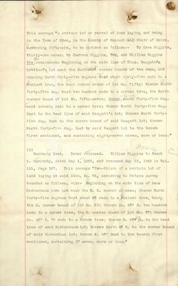
(2)
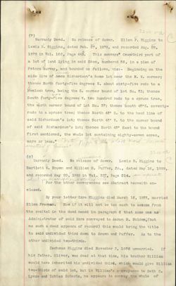
ssu.
Warranty Deed. No release of dower. Oliver Higgins to
Ezra Higgins, William Higgins and Zacheus Higgins, 2nd., dated
Dec. 10, 1852, and recorded Jan. 24, 1855 in Vo 99, Page 392.
This conveys "a certain lot or parcel of land laying and being
in the Town of Eden, in the County of Hancock and State of Maine,
numbering fifty-six, to be divided as follows:-
To Ezra Higgins,
thirty-one acres; to Zacheus Higgins, 2nd, and William Higgins
the
the remainder/- Beginning on the side line of Thos. Wasgattis
Settlerts Lot near the Northeast corner bound$ of the same, and
running North forty-five degrees west about sixty-five rods to a
Hemlock tree, the east corner bound of Lot No. fifty; thence south
forty-five deg. West two hundred rods to a spruce tree, the North
corner bound of lot No. fifty-seven; thence south forty-five deg.
showse
east seventy rods to a spruce tree; thence North forty-five deg.
East to the head line of said Wasgatt's lot; thence North forty
five deg. West to the corner bound of said Wasgatt lot; thence
North forty-five deg. East by said Wasgatt lot to the bounds
first mentioned, and containing eighty-seven acres, more or less."
(3)
sswa
Warranty Deed.
Dower released. William Higgins to Jacob
S. Suminsby, dated May 1, 1860, and recorded May 12, 1860 in Vol.
111, Page 167. This conveys "Two-thirds of a certain lot of
land laying in said Eden, No. 56, according to Peters survey
bounded as follows, viz:- Beginning on the side line of Amos
Richardson home lot near the N. W. corner of same; thence North
forty-five degrees West about 65 rods to a Hemlock tree, being
the E. corner bound of Lot No. 53; thence So. 450 W. two hundred
rods to a spruce tree, the N. corner bound of lot No. 57; thence
So. 45° E. 70 rods to a spruce tree; thence N. 45% E. to the head
line of said Richardsonslot; thence North 45 W. to the corner bound
of said Richardson lot; thence N. 450 East to the bounds first
mentioned, containing 87 acres, more or less."
Ssuta
(4)
Warranty Deed.
Dower released. Jacob S. Suminsby to
Seth S. Lynde and Tobias Roberts, dated Oct. 13, 1868, and
recorded Oct. 15, 1868 in Vol. 131, Page 434. This conveys
"A certain lot or parcel of land situated in Eden aforesaid,
Edur
and bounded and described as follows, to wit: Beginning at a
stake and stones near the County road leading to Somesville
on Stephen Higgins southeast line, and following said line
South forty-five degrees West two hundred rods to a Pine Stub;
then running South forty-five degrees East forty-nine rods to a
Spruce tree: then North forty-five degrees East, two hundred
rods to a stake and stones; then North forty-five degrees West
to the first mentioned bound, containing sixty-one acres, more
or less, as by deed from William Higgins to Jacob S. Suminsby,
recorded in Hancock Registry of Deeds, Book 111, Page 167."
(5)
Quit-claim Deed. No release of dower. Seth S. Lynde to
Tobias Roberts, dated Aug. 24, 1870, and Sept. 28, Copied
recorded
1870 in Vol. 137, Page 168. This deed conveys all interest in
the lot described in paragraph
separate shut
four. see full description
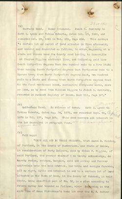
(6)
Full copy:
"KNOW ALL MEN BY THESE PRESENTS, that Aaron B. Holden,
of Portland, in the County of Cumberland, and State of Maine,
in consideration of Forty Dollars, paid by Ellen F. Higgins, of
said Portland, the receipt whereof I do hereby acknowledge, do
hereby remise, release, bargain, sell and convey and forever
quit-claim unto the said Grantee, her heirs and assigns forever,
all my right, title and interest in and to a certain lot of land
situated in the Town of Eden, in the County of Hancock, in said
State, being one-third part of No. 56, in a plan according to
Peters survey and bounded as follows, viz:- Beginning in the
side line of Amos Richardson's home lot near the N. W. corner
thence North forty-five degrees West about sixty-five rods to a
Hemlock tree, being the E. corner bound of lot No. 53; thence
South 450 West two hundred rods to a spruce tree, the N. cor-
57
ner bound of lot No. 51; thence south 45° East to the head line
of said Richardson lot; thence North 45° West to the corner
bound of said Richardson's lot; thence North 45° East to the
bounds first mentioned, the same which said Grantor purchased
under License from the Probate Court of Cumberland County in
said State.
TO HAVE AND TO HOLD the same, together with all the
privileges and appurtenances thereunto belonging, to the said
Grantee, his heirs and assigns forever.
IN WITNESS WHEREOF, I the said Grantor have hereunto
set my hand and seal this sixth day of February, in the year of
our Lord one thousand eight hundred and seventy-eight.
Signed, Sealed and Delivered
in presence of
A. A. Dennett to A. B. H.
Aaron B. Holden. (L.S.)
STATE 0 F MAINE.
Cumberland, SS:
February 27 1878.
Personally appeared the above named Aaron B. Holden,
and acknowledged thetabove instrument to be his free act and
deed, before me,
A. A. Dennett,
Justice of the Peace.
Received Aug. 28, 1878, at 11 h. A. M. and entered by
W. B. Campbell, Reg'r.
Recorded in Vol. 163, Page 128.
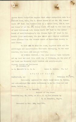
ssu ra
(7)
Warranty Deed. No release of dower. Ellen F. Higgins to
Lewis H. Higgins, dated Feb. 27, 1878, and recorded Aug. 28,
1878 in Vol. 162, Page 443. This conveys" Onex third part of
a lot of land lying in said Eden, numbered 56, in a plan of
Peters survey and bounded as follows, viz:- Beginning on the
anna
side line of Amos Richardson's home lot near the N. W. corner;
thence North forty-five degrees W. about sixty-five rods to a
h
Hemlock tree, being the E. corner bound of lot No. 53; thence
450
South forty-five degrees W. two hundred rods to a spruce tree,
the north corner bound of Lot No. 57; thence south 45°E. seventy+
rods to a spruce tree; thence North 45° E. to the head line of
said Richardson's lot; thence North 450 W. to the corner bound
of said Richardson's lot; thence North 45° East to the bound
first mentioned, the whole lot containing eighty-seven acres,
incoted more or less." Note Refer to the aloir noid anna
of
ssura
(8)
Warranty Deed. No release of dower. Lewis H. Higgins to
Bartlett W. Brown and William H. Puffer, Jr., dated May 16, 1899,
and recorded May 20, 1899 in Vol. 337, Page 214. see separate
sheet
For the other conveyances see Abstract herewith en-
closed.
By your letter Ezra Higgins died March 16, 1855, married
Ellen Freeman. Now if it will not be too much to asume from
the recital in the deed named in paragraph 6 that some one) as
Administrator of said Ezra conveyed to Aaron B. Holden, (but
no such a deed appears of record) this would bring the title
to said undivided third down to Brown and Puffer. As to the
other undivided two-thirds.
Zacheus Higgins died November 3, 1856 unmarried. If
his father, Oliver, was dead at that time, his brother William
would have inherited his undivided third, which would give William
two-thirds of said lot, but in William's conveyance to Seth S.
Lynde and Tobias Roberts, he appears to convey the whole of
the Northwesterly part of said lot No. 56, which would leave his
Heirs as the owners of two-thirds of the Southeasterly part
of said lot. I find by the records that Charles W. Dunbar's
wife's name was Lydia J. Dunbar, and I have examined the records
and do not find any part of said lot conveyed by her. I have
not examined the records to see what became of the property
conveyed to Tobias Roberts named in paragraphs 4 and 5. I have
looked through all of William Higgins' conveyances, and do not
find that he ever conveyed any part of said property except
that named in paragraph 3.
Wolfammure
HANCOCK HOUNTY REGISTRY OF DEEDS.
Ellsworth, Me., Jan. 7, 1905.
I have examined the records of this office in regard to the
title of the lot conveyed by Warranty deed, no release of dower, Lewis
H. Higgins to Bartlett W. Brown and William H. Puffer, dated May 16,
1899, and recorded May 20, 1899 in Vol. 337, Page 214, which is de-
a
scribed as follows:- - "One-third part undivided of a certain lot or
parcel of land lying in said Eden, number ed fifty-six (56) on a plan
of Peters survey, and bounded as follows, viz:-
Beginning on the side line of the Amos Richardson home lot
near the N. W. corher; thence North forty-five degrees west (N, 45° W. )
about sixty-five rods to a hemlock tree being the E. corner bound of
lot No. 53; thence south forty-five degress west (S. 45° W. ) two hun-
dred rods to a spruce tree the north corner bound of Lot No. 57; thence
south forty-five degrees east (S. 450 E.) seventy rods to a spruce tree;
thence North forty-five degrees east (N. 45° E,) to the head line of
said Richardson lot; thence north forty-five degrees west (N. 45° W. )
to the corner bound of said Richardsonlot; thence North forty-five degrees
East (N. 450 E.) to the bound first mentioned, the whole lot contain-
ing eighty-seven (87) acres, more or less.
Being the same premises conveyed to me by warranty deed from
Ellen F. Higgins, dated February 27th, 1878, and recorded in Book 162,
Page 442, of the Registry of Deeds for said County of Hancock, to which
deed and record reference may be had."
Since the date of the above named deed said lot has been
conveyed as follows:-
(1)
Mortgage deed for $75. Dower released. Wm. H. Puffer, Jr. to
Bartlett W. Brown, dated May 16, 1899, and recorded May 20, 1899 in
Vol. 337, Page 217.
This conveys one undivided sixth part of said
lot, and is not discharged.
(2)
Warranty Deed. No release of dower. Wm. H. Puffer, Jr. to Inez
M. Puffer, dated Oct. 13, 1899, and recorded Oct. 24, 1899 in Vol. 342,
Page 265. This conveys one undivided sixth of said lot.
Copied
(
Inez M. Puffer has not conveyed since, and no attachments
appear against her. Bartlett W. Brown has not conveyed since the
date of the deed first herein named and no attachments appear against
him affecting the title to said lot.
I do find an attachment:
Thorndike & Hix vs. W. H. Puffer,
Jr. for $467, dated June 5, 1900, and as he is the husband of Inez M.
Puffer, I leave this for your consideration as said attachment is
not discharged.
If you wish me to run the title back further than the deed
first heren named, you will please return this Abstract with instruc-
tions.
0
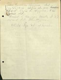
Dec 23,1906 shans she was husband
Ellen Freeman Higgins did
offee of Ezra R Higgins, 92
years old,
buried in Evergreen Cemetey & 87
owner of dob Ellen Hijgins
-
Vol 16 Pge SI of furials,
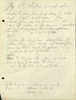
the city cluks secund show
that
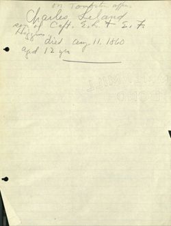
Charles L. Higgins dued any 11, 1860
aged 11 year and 3 mor, The
name given as his parent is
'son of widow E H Hijgin" " initial
Consumption and vol 5 P 183
of E Filtiggions, did of disnol frain
that
1-0
alice B, Higghus daughter of 1
Ellen Higs in died of consumption
June 26,1873 aged 23 years
Vol 6. Ps 23 of Death
alfis
Alia B. Hiysin form June 11. 1850
Parents Egra L.t Ellen t Hyjgins,
Vol b Pge 93 of Rec. of births
both furried in Evergreen Camely
Range S. alice in No 87
Chanks L
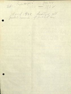
1st Prior to July 5 - Jan
24
1866 1908
Fine of / 908, destryed all
Inolate records of linhed Ear
At
Charles on Tomorrow Leland offers
Ron of Caft E,L. of E, 7.
Higgins
died any 11, 1860
and / 2 yeo
M
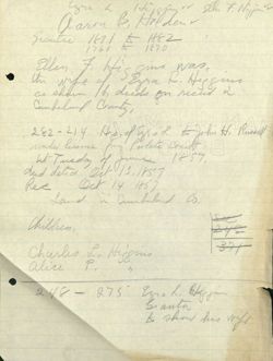
Aarm B, Holden
Ezra L High sv Ellin F. Nigher's VV
Grantice 187.1 t 1882
/
1760 K 1870
Ellen F, His gives was
the wife of Eyra L. Higgins
as sharm deeds on recend w
Cumbeland Country,
282-214 John H, Research
M
under license from partate
Wt-Tuesday of June 1857
dud dated Oct 13,1857
Rec Oct 14 1857
Land in Cambuland Co,
Children,
see
245
Charles L, Higgins
371
alice P,
248 - 275 Ezra L.
branta
& show his wift
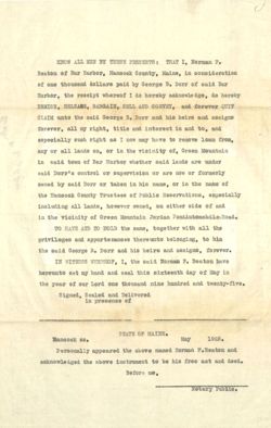
KNOW ALL MEN BY THESE PRESENTS: THAT I, Norman F.
Beaton of Bar Harbor, Hancock County, Maine, in consideration
of one thousand dollars paid by George B. Dorr of said Bar
Harbor, the receipt whereof I do hereby acknowledge, do hereby
REMISE, RELEASE, BARGAIN, SELL AND CONVEY, and forever QUIT
CLAIM unto the said George B. Dorr and his heirs and assigns
forever, all my right, title and interest in and to, and
especially such right as I now may have to remove loan from,
any or all lands on, or in the vicinity of, Green Mountain
in said town of Bar Harbor whether said lands are under
said Dorr's control or supervision or are now or formerly
owned by said Dorr or taken in his name, or in the name of
the Hancock County Trustees of Public Reservations, especially
including all lands, however owned, on either side of and
in the vicinity of Green Mountain Jordan PondAutomobile Road.
TO HAVE AND TO HOLD the same, together with all the
privileges and appurtenances thereunto belonging, to him
the said George B. Dorr and his heirs and assigns, forever.
IN WITNESS WHEREOF, I, the said Norman F. Beaton have
hereunto set my hand and seal this sixteenth day of May in
the year of our Lord one thousand nine hundred and twenty-five.
Signed, Sealed and Delivered
in presence of
STATE OF MAINE.
Hancock SS.
May
1925.
Personally appeared the above named Norman F.Beaton and
acknowledged the above instrument to be his free act and deed.
Before me,
Notary Public.
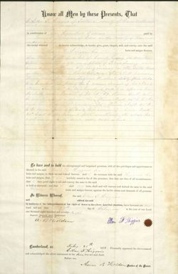
know all Men by these Presents, That
l
Ellen F biggins of Partand county
and state financial
in consideration of line Hundred Dollars
paid by
Jerve of Edew in the exually of 26am cock
insaid all
the receipt whereof
do hereby acknowledge, do hereby give, grant, bargain, sell, and convey, unto the said
16.26 ligher his
heirs and assigns forever,
One third fast of a lot of land lying in said
blen 56 in a plan of Peters lunny and
becoming tis Big inving in the side lene
of
homelot nigi the Al. n cerece
there Math fully five deg sees w about sixty fire rods
to a hemleck tree ting the E cance bound of logetous
Checree South 45 W two hundred node 1/2 a expence hee
its North purse, forcaust of for st 57 there South 45
E seventy red to a shience teach thence Auth 45.8 to the
head here form Richardson's It strence Nut 45th
to the career boen i 4-dais Rich accident lof cheve Nuch
450 East to the borned first mentioned the whole for
cent my lighty sever am mineartes
To have and to hold the aforegranted and bargained premises, with all the privileges and appurtenances
thereof,
to the said sb Neggens his
heirs and assigns, to their use and behoof forever. And do covenant with the said Heggins his
heirs and assigns, that
lawfully seized in fee of the premises; that they are free of all incumbrances;
that
have good right to sell and convey the same to the said
to hold as aforesaid; and that
and
my heirs, shall and will warrant and defend the same to the said
Niggers
heirs and assigns forever, against the lawful claims and demands of all persons.
In Witness Whereof, I the said beller From Hoggins
and
wife-of the said
in testimony of her relinquishment of her right of dower in the above described premises, have hereunto set my
hand and seal this
27th.
day of February
in the year of our Lord
one thousand eight hundred and seventy- light
Signed, Sealed and Delivered
in presence of
a Bycolden
Ellen T Higgins
Lumberland, SS.
Frebey 28th
Ellen
1878. Personally appeared the above-named
and acknowledged the above instrument to be hu free act and deed.
Before me,
Aaron B. Worlden Justice of the Peace.
I
Waffanty Get Deed.
FRO M
Ellen TO
Lewis He Heigher
Hancock
Cumberland SS. REGISTRY OF DEEDS.
Received,
at // H. recorded
1 ang C.M., 28 and 1878
in Book 162 Page 442
ATTEST
Register.
Hall L. Davis, Stationer, 53 Exchange Street, Portland.
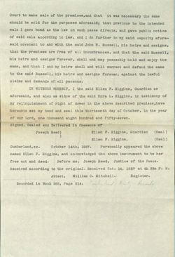
To all persons to whom these presents shall come, Whereas, I, Ellen
F. Higgins, Guardian of Charles L. and Alice B. Higgins minor children of
Ezra L. Higgins, late of Portland, in the County of Cumberland and State
of Maine, deceased, by an Order of the Court of Probate, for the said
County of Cumberland, which was begun and holden at said Portland, on the
first Tuesday of June, last past was Licensed to make sale of the follow-
ing described real estate of said deceased for payment of his just debts
and incidental charges.
Therefore know Ye, that I the said Ellen F. Higgins, Guardian as
aforesaid, as well by virtue of the power and authority to me given, as
aforesaid, as in consideration of the sum of Two hundred dollars paid me by
John W. Russell of said Portland, the receipt whereof, I do hereby acknowl-
edge, do hereby in said capacity give, grant, bargain, sell and convey unto
him the said John W. Russell, his heirs and assigns forever, a certain
lot or parcel of land situated in Cape Elizabeth in said County of Cumber-
land on the Southerly side of a certain street called "B Street" opening
Westerly out of the main road leading over Portland Bridge, and bounded as
follows, viz: Beginning at a stake on said "B Street" one hundred and
fifty feet Westerly from the Northerly corner of the front yard of John S.
Cram's house on said main road; thence running Westerly on said B Street
fifty feet, and from said two points extending back from said B Street in
a Southerly direction, one hundred feet keeping the width of fifty feet.
Meaning hereby to convey a lot fifty feet on said B Street by one hundred
feet deep, and being lot numbered "Sixteen" on a plan of the farm of Elias
Thomas, drawn by William Anson, Civil Engineer and the same conveyed to
Ezra L. Higgins by John S. Cram by his deed bearing date Sept. 1, 1853 and
recorded in Cumberland Registry of Deeds, Book 248, Page 280.
TO HAVE AND TO HOLD the aforegranted premises, with all the privi-
leges and appurtenances thereof, to him the said Russell, his heirs and
assigns, to their use and behoof forever. And I do covenant with the said
Russell in my capacity aforesaid, his heirs and assigns that the said Ezra
B. Higgins died seized of the premises; that I was duly licensed by said
Court to make sale of the premises, and that it was necessary the same
should be sold for the purposes aforesaid; that previous to the intended
sale I gave bond as the law in such cases directs, and gave public notice
of said sale according to law, and I do further in my said capacity afore-
said covenant to and with the said John W. Russell, his heirs and assigns,
that the premises are free of all incumbrances, and that the said Russell,
his heirs and assigns forever, shall and may peaceably hold and enjoy the
same, and that I and my heirs shall and will warrant and defend the same
to the said Russell, his heirs and assigns forever, against the lawful
claims and demands of all persons.
IN WITNESS WHEREOF, I the said Ellen F. Higgins, Guardian as
aforesaid, and also as widow of the said Ezra L. Higgins, in testimony of
my relinquishment of right of dower in the above described premises, have
hereunto set my hand and seal this thirteenth day of October, in the year
of our Lord, one thousand eight hundred and fifty-seven.
Signed, Sealed and Delivered in Presence of
Joseph Reed)
Ellen F. Higgins, Guardian
(Seal)
)
Ellen F. Higgins,
(Seal)
Cumberland,ss.
October 14th, 1857.
Personally appeared the above
named Ellen F. Higgins, and acknowledged the above instrument to be her
free act and deed.
Before me, Joseph Reed, Justice of the Peace.
Received according to the original. Received Oct. 14, 1857 at 4h 33m P. M.
Attest, William C. Mitchell.
Register.
Recorded in
Book 282, Page 214. Cimberloid Cut Records
Higgins, Guard. of
to
Russell
Know all Men by these Presents, Chat
I, Ezra L. Higgins of Portland, County of Cumberland & State of Maine
in consideration of the sum of one thousand dollars
paid by
Franklin Tinkham of said Portland,
the receipt whereof I
do hereby acknowledge, do hereby give, grant, bargain, sell and convey unto the said
Tinkham, his heirs and assigns forever, a certain lot of land with the build-
ings thereon situated on the northwesterly side of Spruce St. in said Portland
and bounded as follows vis. commencing on said Spruce St. at the line of James
Mayberrys land thence Northerly by said Mayberry's line to R. B. Dunn's land
being about sixty feet thence by sd. Dunn's land Northeastwardly forty feet;
thence southeast parallel to the first line and keeping the width of Forty feet
to Spruce Street; thence southwesterly on the line of said Spruce St. forty feet
to the first named bounds being the same premises conveyed to me by said Tinkham
by deed of Mch. 24, 1853 & recorded in Cumb. Registry, Book 244, Page 436.
Not This deed ducribes land Porttan Mavi, it is in
form a warranty Ded. The within clause and signature
are invented A show the park
To have and to Hold, the aforegranted and bargained premises, with all the privileges and appurtenances thereof to
the said
Tinkham his
heirs and assigns, to
their use and behoof forever. And
I
do covenant with the
said
Tinkham his
heirs and assigns, that
I am
lawfully seized in fee of the premises; that they are free of all
incumbrances;
that
I
have good right to sell and convey the same to the said
Tinkham
to hold as aforesaid ; and that
I
and
my
heirs, shall and will warrant and defend the same to the said
Tinkham, his
heirs and assigns forever, against the lawful claims and demands of all persons.
In Witness Whereof,
I the said Ezra L. Higgins and Ellen F. my wife, who hereby
relinquishes her right of dower in the premises
have hereunto set
our hand Sand seal Sthis thirty first
day of
August
in the year of our Lord
one thousand nine-hundred eight hundred and fifty-three.
Signed, Sealed and Delivered
in presence of
James Merrill
Ezra L. Higgins L.S.
James Mayberry
Ellen F. Higgins L.S.
State of Maine, CUMBERLAND, SS. Portland, Aug. 31, 1853 -192-
Personally appeared
the above named-
Ezra L. Higgins
and acknowledged the above instrument to be his
free act and deed.
Before me,
James Merrill
Justice of the Peace.
Received
Aug. 31, 1853
192
at 2 o'clock 50m. P. M.. and recorded according to the original.
Attest,
William C. Mitchell,
Register.
Warranty Deed.
FROM
Ezra L. Higgins
TO
Franklin Tinkham
Cumberland, 55.
Registry of Deeds.
RECEIVED August 31,1853
19-
at
2 H. 50 M P. M., and recorded in
s
Book 248. Page 275.
ATTEST,
William C. Mitchell Register.
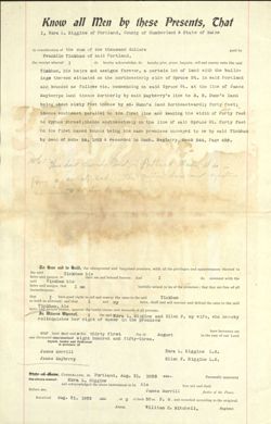
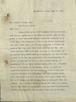
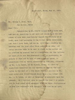
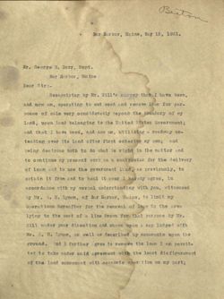
Bar Harbor, Maine, May 12, 1921.
Mr. George B. Dorr, Supt.
Bar Harbor, Maine
Dear Sir:-
Recognizing by Mr. Hill's survey that I have been,
and now am, operating to cut wood and remove loam for pur-
poses of sale very considerably beyond the boundary of my
land, upon land belonging to the United States Government;
and that I have been, and now am, utilizing a roadway ex-
tending over its land after first entering my own; and
being desirous both to do what is right in the matter and
to continue my present work as a contractor for the delivery
of loam and to use the government land, as previously, to
obtain it from and to haul it over I hereby agree, in
accordance with my verbal understanding with you, witnessed
by Mr. A. H. Lynam, of Bar Harbor, Maine, to limit my
operations hereafter for the removal of loam to the area
lying to the west of a line drawn for that purpose by Mr.
Hill under your direction and shown upon a map lodged with
Mr. A. H. Lynam, as well as described by monuments upon the
ground. And I further agree to remove the loam I am permit-
ted to take under said agreement with the least disfigurement
of the land consonant with economic operation on my part;
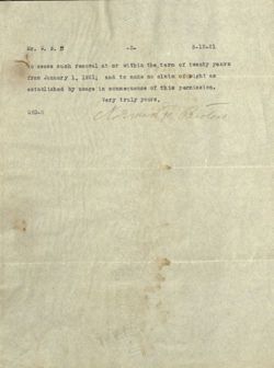
Mr. G. B. B
-2-
5-12-21
(
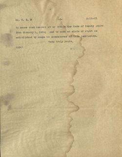
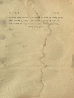
to cease such removal at or within the term of twenty years
from January 1, 1921; and to make no claim of right as
established by usage in consequence of this permission.
Very truly yours,
GBD-M
Norming Beoton
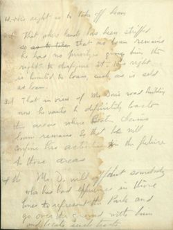
Wi-His night is to take off foam
2.1 that where land has been striffed
so as t take that no loan remains
he has no privilyes giving him the
right to disfigure it. His right
is hinted to loam, such as is sold
as loan.
3d That in view of Mrs Dass's road building
now he wants & definitely bact
the area where Beath claims
loan remains So that be will
confine his actinti tin the fuluire
A those areas
4 th Mr D. will off/dist somebody
who has had experime in these
lines to represent the Park and
go over the ground with him
and locate such hants
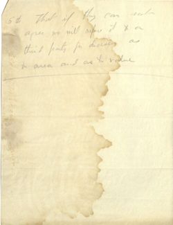
kid 5th that if they can not
apr we will affers it to a
third party for dicessary as
2 area and as to value
Bar Harbor, Maine, May 12, 1921.
Mr. George B. Dorr, Supt.
Bar Harbor, Maine
Dear Sir:-
Recognizing by Mr. Hill's survey that I have been,
and now am, operating to cut wood and remove loam for pur-
poses of sale very considerably beyond the boundary of my
land, upon land belonging to the United States Government;
and that I have been, and now am, utilizing a roadway ex-
tending over its land after first entering my own; and
being desirous both to do what is right in the matter and
to continue my present work as a contractor for the delivery
of loam and to use the government land, as previously, to
obtain it from and to haul it over I hereby agree, in
accordance with my verbal understanding with you, witnessed
by Mr. A. H. Lynam, of Bar Harbor, Maine, to limit my
operations hereafter for the removal of loam to the area
lying to the west of a line drawn for that purpose by Mr.
Hill under your direction and shown upon a map lodged with
Mr. A. H. Lynam, as well as described by monuments upon the
ground. And I further gree to remove the loam I am permit-
ted to take under said agreement with the least disfigurement
of the land consonant with economic operation on my part;
Mr. G. B. B
-2-
5-12-21
to cease such removal at or within the term of twenty years
from January 1, 1921; and to make no claim of right as
established by usage in consequence of this permission.
Very truly yours,
GBD-M
Biston
Bar Harbor, Maine, May 12, 1921.
Mr. George B. Dorr, Supt.
Bar Harbor, Maine
Dear Sir:-
Recognizing by Mr. Hill's survey that I have been,
and now am, operating to out wood and remove loam for pur-
poses of sale very considerably beyond the boundary of my
land, upon land belonging to the United States Government;
and that I have been, and now am, utilizing a roadway ex-
tending over its land after first entering my own; and
being desirous both to do what is right in the matter and
to continue my present work as a contractor for the delivery
of loam and to use the government land, as previously, to
obtain it from and to haul it over I hereby agree, in
accordance with my verbal understanding with you, witnessed
by Mr. A. H. Lynam, of Bar Harbor, Maine, to limit my
operations hereafter for the removal of leam to the area
lying to the west of a line drawn for that purpose by Mr.
Hill under your direction and shown upon a map lodged with
Mr. A. H. Lynam, as well as described by monuments upon the
ground. nd I further gree to remove the loan I am permit-
ted to take under said agreement with the least disfigurement
of the land consonant with economic oper tion on my part;
Mr. G./B. #
2-
5-12-21
to cease such renoval at or within the term of twenty years
Iron January 1, 1921; and to make no claim of right as
established by usage in consequence of this permission.
Very truly yours,
GBD-11

