
From collection Jesup Library JDR Jr. Collection

Page 1
Page 2
Page 3
Page 4
Page 5
Page 6
Page 7
Page 8
Page 9
Page 10
Page 11
Page 12
Page 13
Page 14
Page 15
Page 16
Page 17
Page 18
Page 19
Page 20
Page 21
Page 22
Page 23
Page 24
Page 25
Page 26
Page 27
Page 28
Page 29
Page 30
Page 31
Page 32
Page 33
Page 34
Page 35
Page 36
Page 37
Page 38
Page 39
Page 40
Page 41
Page 42
Page 43
Page 44
Page 45
Page 46
Page 47
Page 48
Page 49
Page 50
Page 51
Page 52
Page 53
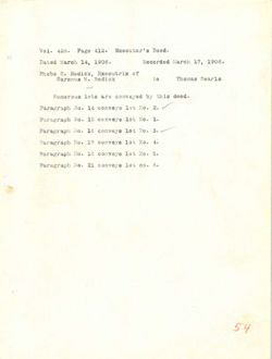
Page 54
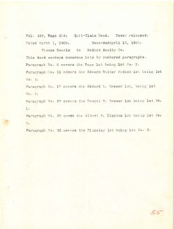
Page 55
Page 56
Page 57
Page 58
Page 59
Page 60
Page 61
Page 62
Page 63
Page 64
Page 65
Page 66
Page 67
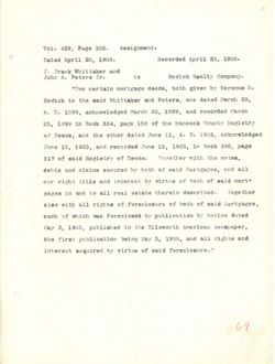
Page 68
Page 69
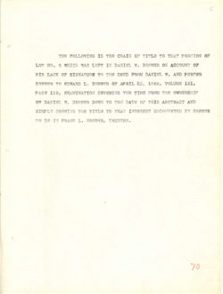
Page 70
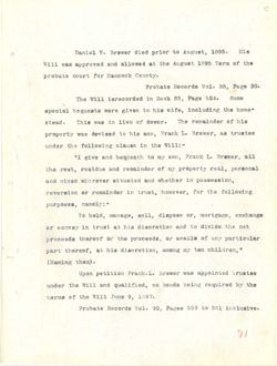
Page 71
Page 72
Page 73
Page 74
Page 75
Page 76
Page 77
Page 78
Page 79
Page 80
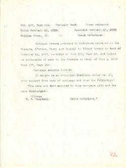
Page 81
Page 82
Page 83
Page 84
Page 85
Page 86
Page 87
Page 88
Page 89
Page 90
Page 91
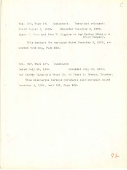
Page 92
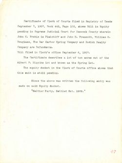
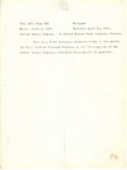
Page 93
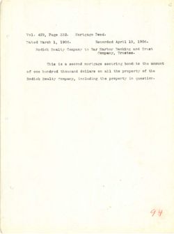
Page 94
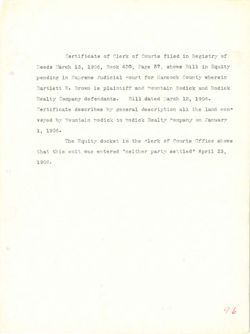
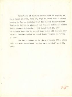
Page 95
Page 96
Page 97
Page 98
Page 99
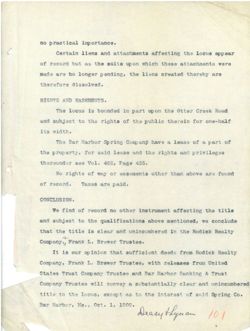
Page 100
Page 101
Page 102
Page 103
Page 104
Page 105
Page 106
Page 107
Page 108
Page 109
Page 110
Page 111
Page 112
Page 113
Page 114
Page 115
Page 116
Page 117
Page 118
Page 119
Page 120
Page 121
Page 122
Page 123
Page 124

Page 125
Page 126
Page 127
Page 128

Page 129
Page 130

Page 131
Page 132

Page 133
Page 134
Page 135
Page 136

Page 137
Page 138

Page 139
Page 140

Page 141
Page 142
Page 143
Page 144
Page 145
Page 146
Page 147
Page 148
Page 149
Page 150
Page 151
Page 152
Page 153
Page 154
Page 155
Page 156
Page 157
Page 158
Page 159
Page 160
Page 161
Page 162
Page 163
Page 164
Page 165
Page 166
Page 167
Page 168
Page 169
Page 170
Page 171
Page 172
Page 173
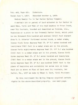
Page 174
Page 175
Page 176
Page 177
Page 178
Page 179
Page 180
Page 181

Page 182

Page 183
Page 184
Page 185
Page 186
Page 187
Page 188
Page 189
Page 190
Page 191
Page 192

Page 193
Page 194

Page 195
Page 196

Page 197
Page 198

Page 199
Page 200

Page 201
Page 202

Page 203
Page 204
Page 205
Page 206

Page 207
Page 208
Page 209
Page 210
Page 211
Page 212
Page 213
Page 214
Page 215
Page 216
Page 217
Page 218
Page 219
Page 220
Page 221
Page 222
Page 223
Page 224
Page 225
Page 226
Page 227
Page 228
Page 229
Page 230

Page 231
Page 232
Page 233
Page 234

Page 235
Page 236

Page 237
Page 238

Page 239
Page 240
Page 241
Page 242
Page 243
Page 244
Page 245
Page 246
Page 247
Page 248
Page 249
Page 250
Page 251
Page 252
Page 253
Page 254
Page 255
Page 256

Page 257
Page 258
Page 259
Page 260
Page 261
Page 262

Page 263
Page 264
Page 265
Page 266
Page 267
Page 268
Page 269
Page 270

Page 271
Page 272
Page 273
Page 274
Page 275
Page 276
Page 277
Page 278
Page 279
Page 280
Page 281
Page 282
Page 283
Page 284
Page 285
Page 286
Page 287
Page 288
Page 289
Page 290
Page 291
Page 292
Page 293
Page 294
Page 295
Page 296
Page 297
Page 298

Page 299
Page 300
Page 301
Page 302
Page 303
Page 304
Page 305
Page 306
Page 307
Page 308
Page 309
Page 310
Page 311
Page 312

Page 313
Page 314
Page 315
Page 316

Page 317
Page 318
Page 319
Page 320

Page 321
Page 322
Page 323
Page 324

Page 325
Page 326

Page 327
Page 328

Page 329
Page 330
Page 331
Page 332

Page 333
Page 334

Page 335
Page 336

Page 337
Page 338
Page 339
Page 340
Page 341
Page 342
Page 343
Page 344
Page 345
Page 346

Page 347
Page 348
Page 349
Page 350
Page 351
Page 352

Page 353
Page 354

Page 355

Page 356
Page 357
Page 358

Page 359
Page 360

Page 361
Page 362

Page 363
Page 364
Page 365
Page 366
Page 367
Page 368

Page 369
Page 370
Page 371
Page 372
Page 373
Page 374
Page 375
Search
results in pages
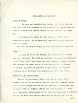
Dry Mountain Abstract + copy
Dry Mountain Tract.
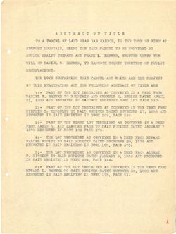
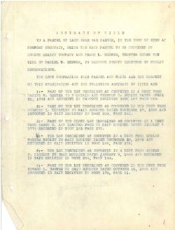
ABSTRACT OF TITLE
TO A PARCEL OF LAND NEAR BAR HARBOR, IN THE TOWN OF EDEN AT
NEWPORT MOUNTAIN, BEING THE SAME PARCEL TO BE CONVEYED BY
RODICK REALTY COMPANY AND FRANK L. BREWER, TRUSTEE UNDER THE
WILL OF DANIEL W. BREWER, TO HANCOCK COUNTY TRUSTEES OF PUBLIC
RESERVATIONS.
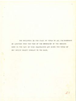
THE LOTS COMPRISING THIS PARCEL AND WHICH ARE THE SUBJECT
OF THIS EXAMINATION AND THE FOLLOWING ABSTRACT OF TITLE ARE
1:- PART OF THE LOT DESCRIBED AS CONVEYED IN A DEED FROM
DANIEL W. BREWER TO FOUNTAIN AND SERENUS H. RODICK DATED APRIL
21, 1883 AND RECORDED IN HANCOCK REGISTRY BOOK 187 PACE 510.
2:- PART OF THE LOT DESCRIBED AS CONVEYED IN THE DEED FROM
STEPHEN L. KINGSLEY TO SAID RODICKS DATED NOVEMBER 27, 1886 AND
RECORDED IN SAID REGISTRY IN BOOK 209, PAGE 246.
3:- PART OF THE FIRST LOT DESCRIBED AS CONVEYED IN A DEED
FROM AARON G. AND LEANDER PAGE TO SAID RODICKS DATED JANUARY 7
1878 RECORDED IN BOOK 163 PAGE 270.
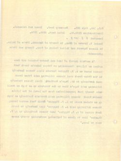
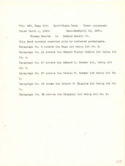
4:- THE LOT DESCRIBED AS CONVEYED IN A DEED FROM EDWARD
WALTER RODICK TO SAID RODICKS DATED DECEMBER 29, 1879 AND
RECORDED IN SAID REGISTRY IN BOOK 168, PAGE 375.
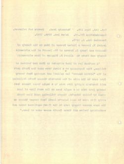
5:- THE LOT DESCRIBED AS CONVEYED IN A DEED FROM ALBERT
F. HIGGINS TO SAID RODICKS DATED ,JANUARY 9, 1886 AND RECORDED
IN SAID REGISTRY IN BOOK 204, PAGE 144.
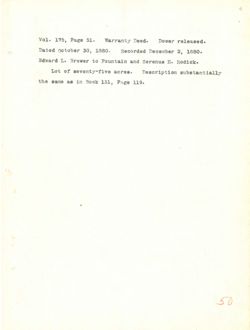
6: - PART OF THE LOT DESCRIBED AS CONVEYED IN THE DEED FROM
EDWARD L. BREWER TO SAID RODICKS DATED OCTOBER 30, 1880 AND
RECORDED IN SAID REGISTRY IN BOOK 175, PAGE 51.
1.
HITIT TOAHTGEA
TA VISTORY TO KWOT HHT WI , HAS TVAJ TO JADHAS A OT
YE THE or JEDHAS SPAR HAT SHINE ,MIATHUOL THOUWH
THT SETAUST .I AKA MOICOS
DIIEUS to SHATEUMT YTHUOD 20007LAH QT .W JAINACC TO SIIN
TOKLEUS HHT HOI IV EXA THOAAS 21HT STOJ GMT
ELITIT E0 TOAHTREA SHT CIVA MOITAMINAYA BIRT to
MORT asic A KI BA TOI EAT TO THAS - I
IIR CETTAC MOITOS .H TUA MIATHUC'E OT SEWERE .W CHIMAT
.018 XOAE £8I 2008 YATRICKA FOODKAH MI TWA 8081 ,IS
MOHY ght MI 2A TOJ XHT TO THAS - S
CIMA 8881 EXPIRES CIAS OT YETEDHIX ..I CHICATA
,APS HOASE ,EOS 2008 VI YATAIDEA CIAR MI
aast A BA TOJ Taxie 3HT 50 THAY - &
r YHAUMAT OTTAC CIAS OT IDAY AXA .0 RIOHAA
.ORS GOAY Ear 2008 ML 8881
CHANCE MORT CHIC A VI 3A TOJ EHT - £
CICA QT8I .es THTAC EXPIRES CIAR CT FOITOR HETTAV
KOAS ,8as 07008 II YATRIDAR TIAS XI
THREJA MORT drea A II RA CERTIFICATE TOJ gHT -:c
GTCA 8881 if YHAURAT OXTAC EXPIRES CLAS OT .
.API EDAT ,AOS XOOK MI YETRIOHA CIA XI
TOTAL AHT KI BA TOJ XIII to THAT -:0
AKA 0881 ,OE FEETOTOO THTAC EXPICAR CIA8 OT HAWAGE .I CHAWIA
.DC BOAT 2008 XI YATEIDER CIAC XI CITIZONE
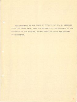
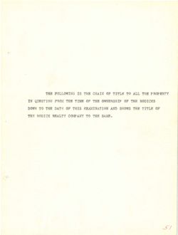
THE FOLLOWING IS THE CHAIN OF TITLE TO LOT NO. 1, REFERRED
TO ON THE TITLE PAGE, FROM THE OWNERSHIP OF THE BINGHAMS TO THE
OWNERSHIP OF THE RODICKS, EXCEPT MORTGAGES WHICH ARE GROUPED
BY THEMSELVES.
2.
CHALLEN TOJ OT MATT TO MIAMO SHH BI
HHT OT ant TO THY MORT ,HOAT ETTIT HHT no OF
CESUCHA HOIHW EHT TO
VII
s
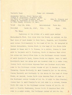
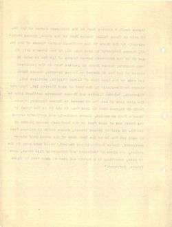
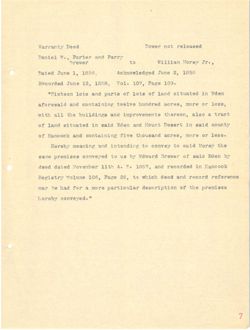
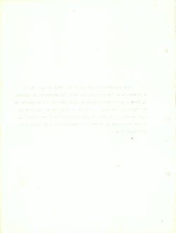
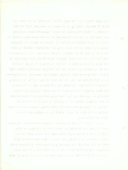
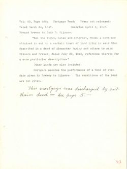
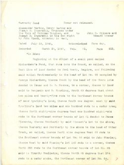
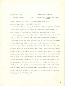
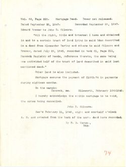
Warranty Deed
Dower not released.
Alexander Baring, Henry Baring and
Joseph R. Ingersoll, Trustees under
the Will of William Bingham, and
to
John D. Gilmore and
Joseph R. Ingersoll in his own right
Edward Brewer
by John Black, Attorney in Fact,
Dated
July 29, 1845,
Acknowledged Same day,
Recorded
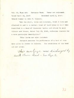
March 24, 1847,
Vol.
81,
Page
211,
"In Eden:
Beginning at the outlet of a small pond called
Richardson's Pond, that runs into the Sound, so called, on the
East line of land deeded to Joel Emery, Esquire, and following
said outlet Southwesterly to the head of lot No. 95 occupied by
George Richardson; thence South by the head of the Shore lots
deeded to Isaac and G. B. Soames, to a corner; thence by land
sold to Benjamin and E. Spurling, South 89 degrees East about
two miles and twenty-five rods to the Northeast corner bounds
of said Spurling's land; thence South one degree west by said
Spurling's land two miles and one hundred rods to a cedar tree;
thence North eighty-nine degrees West one hundred eighty-six
rods to the Northeast corner bounds of lot 81 deeded to James
Clements; thence Southerly by said Clement's lot to the shore;
thence Easterly and Northerly by the shore to the head of Otter
Creek, so called; thence North nine degrees West 69 rods to
the Southeast corner bounds of lot No. 86 sold to John Stanley;
thence West by said Stanley's lot 140 rods to a corner; thence
North 206 rods to the Northwest corner bounds of lot No. 85
sold to Timothy Smalledge; thence North 80 degrees East 184
rods to a cedar stake, the Northeast corner of lot No. 84;
3.
.beaseIst for rawoo
bee(I
bits snirse VINSH Batres
assJust .fl dqeact
brs @TOMILD a anot
of
bris matifie to IIEW gilt
rewere brewb
two aid still floareyaI . dqseet
,JOST as astot to
ysh east
CA8L ,98 VINT better
IIS
9369
IS
.IOV
CASI ,AS doren
bebressE
:1066 (II"
belies broq fisma s to Jeftro gdt to
9NJ mo ,belfoo 08 bawes geld ofal am tells
gabwollon bate Isot of 650006 baeI to shif jast
Ed befguogo 28 .on tol to based out of Vf79789w JelJuo Bisa
ajoi grode 9NT to beed eilt go 997090
bast rd somest is of .80 .) bas oasal of beb995
twods Jesh 8997396 08 .¥ has of bloa
abaved 197700 gift of abor has owt
bisa vd jaew 3997395 and days adidas ;basi 5fsa to
78695 a of abor erro 5mm aeltm ow3 billsf s'antITuq8
berbard 9110 Jaew Atron somed
asaust of 595995 18 JOI to abstrod TONTOO of abor
grift of JOI a'tner910 bisa Vd Virgition socient
Tet#0 to beed gift of erorie 9.45 Vd brue
of abor ea Jagil 299789.6 griff somedt ;beffer oa 20040
ndot of bloa as .oll tof to abnirod 197100 gift
soment Prefitos s of abor ONI JOI 51.00 to" jael soment
CB .00 JOL to abroad taewatroll est of abor aos daron
$81 test 8997395 08 estedt ;99b9ffsm8 of 6108
E
iss .ON JOI to 190000 Jasadtion edit rebes S of abor
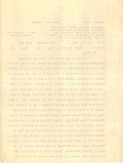
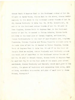
thence South 9 degrees East to the Southeast corner of Lot No.
82 sold to James Walls; thence East to the shore; thence North-
easterly by the shore to the southwest corner bounds of lot No.
63; thence Northerly by lots Nos. 63, 62 Wm. Lynam's lot, 61
and 60 to the Southwest corner bounds of lot No. 59 sold to
Dean Higgins; thence North 86 degrees West to the Southwest
corner of lot No. 58 deeded to Tobias Roberts; thence North
194 rods to the head line of Israel Higgins, settlers lot,
thence Northwesterly by the head of said Higgins lot, Humphrey
Stanwoods, Soloman Higgins and Thomas Wasgatts settlers lots to
the side line of lot No. 56 deeded to Oliver Higgins; thence
South 45 degrees West by lots Nos. 56 and 57 to the Great or
Young's Pond so called, thence Southerly and Northerly around
the South end of said Pond to the Southeast corner bounds of
lot No. 55 sold to Edward Brewer; thence North 63 degrees West
by said lot No. 55 to the East side of the small pond afore-
mentioned; thence Southerly and Westerly round said pond to the
outlet, the place of beginning and containing 6144 acres, more
or less, according to a survey and plan of said town by James
Peters, Surveyor."
4
.011 joi to 197700 edt of tast 8997995 e sonart
-Afton sonedt istoria est of Jask somedit ;aftell escost of 5108 SB
ON 301 to abased 197100 edj of eroda SITI rd VITeJase
Ia ,JOI aimsayJ **** sa ,83 .80% atof Vd soned EED
of 6.0o ea ,OM JOI to abmual 29/700 9dt of 00 bre
eilth 08 taew 8997395 38 daron sameds ;aniagiH mssC
difrolf ;atredor astdoT of 595995 88 .or FOI to TORIOO
,FOI Iesyal to 9HII been gold OJ abor ACI
Verificant ,JOI animath 61s8 to beed gift Ver
03 8J0I arefites attagasil assiont bres ,aboownes?
admin ;ariggth TOVILO of bebseb as .OH JOI to anil obia gdf
TO JSST0 9dd of PC Brts aa .aok ajoi rd JeeW as
bruors bns ,Belino CE buog alganeY
to abased 19/1/05 jassificer erit of 5909 bise to bas divor edt
Jaew 6997996 ea deroll brewbs of bloa aa .ou JOL
5noq Ifana OST to sbia dant sift of cc. 6011 JOI 5188 rd
and of 5mog basor VireJaew bre
9704 , AALA 5.08 gringlast to 95819 and 139IJ30
rd moj bhee to ms[q bas verwa is of anthrooms ,aeel 20
,879399
H
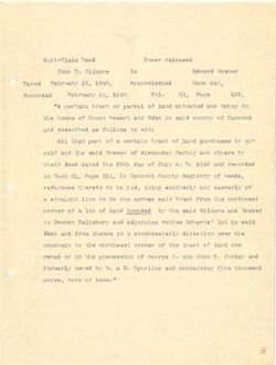
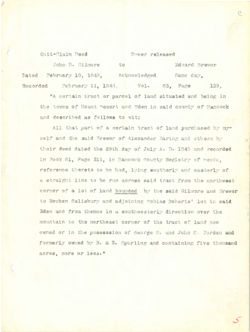
Quit-Claim Deed
Dower released
John D. Gilmore
to
Edward Brewer
Dated
February 10, 1848,
Acknowledged
Same day,
Recorded
February 11, 1848,
Vol.
83,
Page
139,
"A certain tract or parcel of land situated and being in
the towns of Mount Desert and Eden in said county of Hancock
and described as follows to wit:
All that part of a certain tract of land purchased by my-
self and the said Brewer of Alexander Baring and others by
their deed dated the 29th day of July A. D. 1845 and recorded
in Book 81, Page 211, in Hancock County Registry of needs,
reference thereto to be had, lying southerly and easterly of
a straight line to be run across said tract from the northwest
corner of a lot of land bounded by the said Gilmore and Brewer
to Reuben Salisbury and adjoining Tobias Roberts' lot in said
Eden and from thence in a southwesterly direction over the
mountain to the northeast corner of the tract of land now
owned or in the possession of George N. and John S. Jordan and
formerly owned by B. & E. Spurling and containing five thousand
acres, more or less."
5
b9889I97 I9WCT
best
TOW978 brewbH
of
STORIED .CE adot
yeb 91188
bonbeIword[bA
,8481 ,Of beist
,EEI
9784 ,&8
.LOV
.8481 ,II
bebrooeA
at suited bass betaujia 5mm to 20 Josai ristics A"
to bise ni nebt brus 17989C Javor to sds
:J1w ct awoffor 8£ bedtroagh brus
-Tear to boar to SOETF S to 378q Fedj LIA
aredio hrs. griffe rebnaxeIA to 10w978 bisa sig firms 9198
brus 208£ .IT .A VIGE to VEB dtes and botsh heeb right
rabeer to various AboorsH at ,IIS 9384 ,18 2008 at
to Viretass brea Virerificoa gaivy ,5ed ed of oferent
Jaswifron gilt mort JOSTI bise BACTOS NUT ed of emis timierta £
rewere bas STORIAD bise yof bebtwod best to 361 £ 40 197705
5168 pl JOI asidor bas medical of
only TOVO is os somed 0019 5rs. 1995
worr basi to dosed ent to Tentes desertion edid of alainvon
brus mibbot .2 adot bite it 931099 to silt at TO berwwo
ovir his .II to E 150 bsawo Xfrennet
".889I to 9.00 ,89198
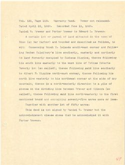
Quit-Claim need
Dower not released
Edward Brewer
to
Daniel W., Porter and Perry
Brewer
Dated November 11, 1857, Acknowledged same day,
Recorded same day, Vol. 106, Page 26.
Various lots and also, "a certain tract or parcel of land
situate and being in the towns of Eden and Mount Desert in
said county of Hancock and described as follows, to wit:-
All that part of a certain tract of land purchased by my
self and John D. Gilmore of Alexander Baring and others by
their deed dated the 29th day of July A. D. 1845 and recorded
in Book 81, Page 211, in Hancock County Registry of Deeds
reference thereto to be had, lying southerly and easterly of
straight line to be run across said tract from the northwest
corner of a lot of land bonded by Gilmore and Brewer to Reuben
Salisbury and adjoining Tobias Roberts' lot in said Eden and
from thence in a southwesterly direction over the mountains
to the northeast corner of the tract of land now owned or in
the possession of George N. and John S. Jordan and formerly
owned by B. & E. Spurling and containing five thousand acres,
more or less, being the same tract purchased by me of John D.
Gilmore as will appear by his deed to me recorded in Hancock
Registry, Book 83, Page 139.
6
59889197 jos rewot
SSST mission
VITOS bre 793704 call Istrest
of
rewers Brewbii
79W9T8
91188 hegbeIwonisa rasi ,IL Tedmevol 693.80
.88 9389 ,301 .IoV 91108 b9b1009H
brai to Isoreq to fosty 6" cals 5.18 8I0I avotrev
at favour brus (19.b) to anwoj and st garted bms stendie
-:jtn of ,awoIfo? as bedtroach brue to VIEWOO bisa
-100 vot beastoring bosi to sourd DISTICS fill to jise jert IIA
vd aredo 598 going to stomIto .IT adol bos 3598
bebroost has EASI .0 .A VINT to Vsb dies giff betab b99b riedj
about to VINION NI ,ISS 9369 ,18 2008 at
to Viretaso bod anivi 96 of offereris 900979197
Jaewitzon and MOTI bisa 380Y98 DAY ad 09 sail
reduce of revers brs 970mL10 rd betwood bast to joi s to 790900
have nebt 5188 of JOI ladredor astdot bus prodelish
anistation and Tevo cold9ey1b B ml mort
at TO benwo work bnsl to desir gift to desedficit and os
bore mebror .3 affot 50g M 937090 to defeasaboq and
89705 breasons svit quinksthon 6113 . B .it xr berwo
II adol to SCL rd beastoring Joses gift gried ,889£ xo arom
2000mail at bebicost our ct beeb and rd resgas fftv as STOMIED
".CEI 9729 ,EE 2008
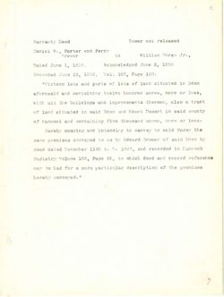
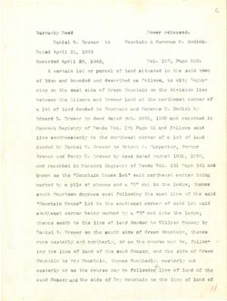
Warranty Deed
Dower not released
Daniel W., Porter and Perry
Brewer
to
William Morey Jr.,
Dated June 1, 1858,
Acknowledged June 2, 1858
Recorded June 12, 1858, Vol. 107, Page 109.
"Sixteen lots and parts of lots of land situated in Eden
aforesaid and containing twelve hundred acres, more or less,
with all the buildings and improvements thereon, also a tract
of land situated in said Eden and Mount Desert in said county
of Hancock and containing five thousand acres, more or less.
Hereby meaning and intending to convey to said Morey the
same premises conveyed to us by Edward Brewer of said Eden by
deed dated November 11th A. D. 1857, and recorded in Hancock
Registry volume 106, Page 26, to which deed and record reference
may be had for a more particular description of the premises
hereby conveyed."
7
beaseIer ton rewoT
beet
67799 brus ,AV
.IT Verom mattier
08
TOWST
8881 ,S saut
8681 I enut betan
.00L 9759 ,POI ,IOV 8881 ,SL SHIT
nebit at betentis bmss to 8J0I to esteq bris ajot
causi TO erosi ,4970£ barbari bots bicastots
JOSTI s oels bills agriblist eit IIs Httw
vance bisa of smith bore netz blee all beterista 6581 to
.saeI TO STOD brusawons 9717 hns to
sait yeroll bisa of V9VH00 03 bas VdersH
to 195H bisa to reware biswba vd as of beverroo asalmerq ansa
(11 bebreant brus ,SEEL NJIL Teddevot betth bast
570097 bors besb dolow 00 ,as 93.69 ,AOD SOULEV
esalmera gift to STOP s rot bad ed
If beternoo
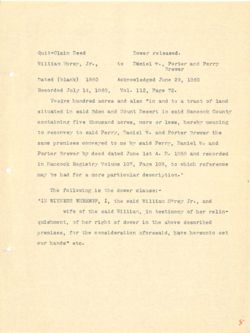
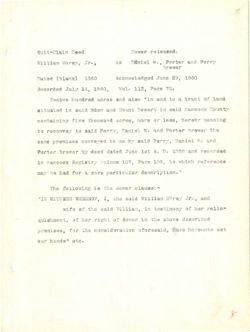
Quit-Claim Deed
Dower released.
William Morey, Jr.,
to
Daniel W., Porter and Perry
Brewer
Dated (blank) 1860
Acknowledged June 29, 1860
Recorded July 14, 1860,
Vol. 112, Page 72.
Twelve hundred acres and also "in and to a tract of land
situated in said Eden and Mount Desert in said Hancock County
containing five thousand acres, more or less, hereby meaning
to reconvey to said Perry, Daniel W. and Porter Brewer the
same premises conveyed to me by said Perry, Daniel W. and
Porter Brewer by deed dated June 1st A. D. 1858 and recorded
in Hancock Registry Volume 107, Page 109, to which reference
may be had for a more particular description."
The following is the dower clause:-
"IN WITNESS WHEREOF, I, the said William Morey Jr., and
wife of the said William, in testimony of her relin-
quishment, of her right of dower in the above described
premises, for the consideration aforesaid, have hereunto set
our hands" etc.
8
beaselet rewor
bega
bas 99JY0Q of
1.27 meiffin
rewerp
0881 , is snot bagbs IwordiaA
0081 (sineld) badsa
.sr ensa ,SIE .LoV .0081 ,DE EINT
brail to JOSYS s of brus ni" cafs hrs 89708 barbara 9VISTT
hisa at $7989T 5h nebs blsa ml bessujba
galasen Wasted reser 20 STOCE ,29756 breasorts evit anthistros
enf TOWSTE retica has .V Islast extred bise of of
bas .1 IslasT Disa rd any of sease
bebroomy brs 8881 ..I .A J21 grust betsh boob VO retrol
Holdw of reof 97.89 ,POI emisfor 12381398 at
97001 S 709 ball ed
:eausis rewob SAT at gelwo,fict SNT
brus III VOTO meffier blse sit ,I WI"
-allen 79N to tromitest at MAILIEW bine 9.18 to stim
b9d190asb svode 914 at reweb to their rest to
Jee evelf soffershlanco gilt 209
"abasi asso
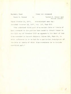
Warranty Deed
Dower not released
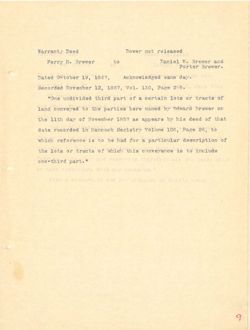
Perry H. Brewer
to
Daniel W. Brewer and
to
Porter Brewer.
Dated October 19, 1867,
Acknowledged same day.
Recorded November 12, 1867, Vol. 130, Page 255.
"One undivided third part of a certain lots or tracts of
land conveyed to the parties here named by Edward Brewer on
the 11th day of November 1857 as appears by his deed of that
date recorded in Hancock Registry Volume 106, Page 26, to
which reference is to be had for a particular description of
the lots or tracts of which this conveyance is to include
one-third part."
and reserving therefron ali
sold
and
conveyed.
9
b9889I9T rewor
5990 VISSTICW
TOWSTE W I9INET
of
rewerk 791209
v.b.b 91182
8881 ,EI gaut bajea
a
.081 9384 ,IEI .IoV
8881 SS scurt babroool
+1989(T) at betaujia bmsf to 1907.8q TO JOI risties A"
of ,awoffot as bedfroagb bas bebavod brs bisastors brs
-:jiw
5ysw6f vd bref gift SIS to bebivibox 910
to V.b.b NJII get betsh beeb vd TOW978 87799 bms as of rewere
'
,80£ SAVIOV babroost PE8L .....A rednevor
dollww abres estt IIB bas gattq9ox9 ,as 9389
10 bms bioa ever 9W
.9V05 al.IINH IS betsud La JOI brus S CafA
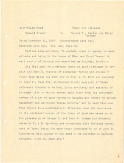
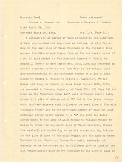
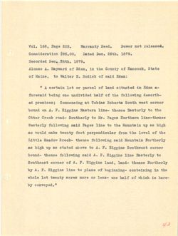
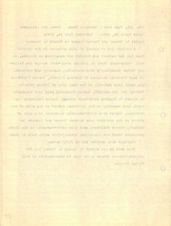
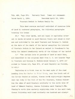
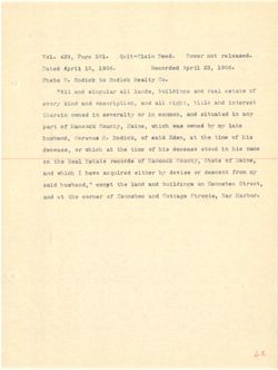
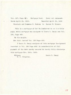
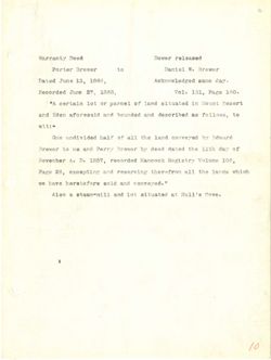
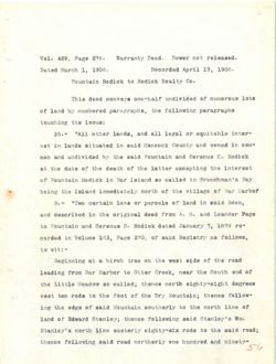
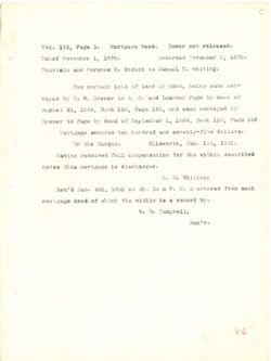
Warranty Deed
Dower released.
Daniel W. Brewer to
Fountain & Serenus H. Rodick.
Dated April 21, 1883
Recorded April 28, 1883,
Vol. 187, Page 510.
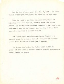
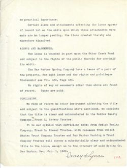
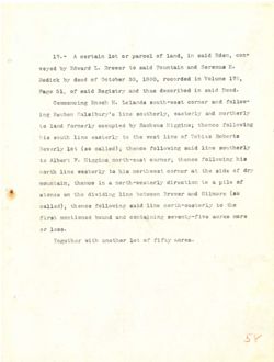
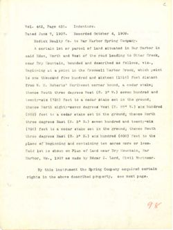
A certain lot or parcel of land situated in the said town
of Eden and bounded and described as follows, to wit: Begin-
ning on the east side of Green Mountain on the division line
between the Gilmore and Brewer land at the northwest corner of
a lot of land deeded to Fountain and Serenus H. Rodick by
Edward L. Brewer by deed dated Oct. 30th, 1380 and recorded in
Hancock Registry of Deeds Vol. 175 Page 51 and follows said
line southwesterly to the northeast corner of a lot of land
deeded by Daniel W. Brewer to Orient H. Carpenter, Porter
Brewer and Perry H. Brewer by deed dated August 18th, 1868,
and recorded in Hancock Registry of Deeds Vol. 131 Page 341 and
known as the "Mountain House Lot" said northeast corner being
marked by a pile of stones and a "B" cut in the ledge; thence
south fourteen degrees east following the east line of the said
"Mountain House" lot to the southeast corner of said lot said
southeast corner being marked by a "3" cut into the ledge;
thence south to the line of land deeded to William Swazey by
Daniel W. Brewer on the south side of Green Mountain, thence
runs easterly and northerly, or as the course may be, follow-
ing the line of land of the said Swazey, and the side of Green
Mountain to Dry Mountain, thence Southerly, westerly and
easterly or as the course may be following line of land of the
said Swazey and the side of Dry Mountain to the line of land of
//
rewell
besit KINSTISW
H address s
of 197978 w Ielnsa
8685 , IS lirqA bejet
.018 9989 SSI .LOV
,8881 ,88 ItryA bebrooal
KWOJ bise edd off bersutta boar to TO JOI started A
:flw of as b9dfrb89b brus befored bite neby to
sali molafvis odt sro rison 39970 to shie tass set 110 gain
to 198700 Jaswifton add ts breaf 197978 5.16 970mlth eilt deewled
god Notbox it amerge of bebeeb basi to tof S
at 59010097 5hr 0881 ESFOE .500 betsh boeb 10 Tower .3 brew57
bise awollot bre IC 8384 ave .IoV abeet to $300msH
basi to JOI & to Tentoo desedition ent of enti
797709 .K Theiro of w Iglnet rd bebesh
8881 ,4481 teugen bejab besh rd 19W97E .H VTT99 Brs. 197978
brs IAE 9389 18£ .IoV absent to st BILLS
gated 190700 receiption 5th "J0J 9800H edf 88 aword
;9y091 eilt at two "8" JS Brus aerota to effq is ver bedrum
bisa edt to SMIL Jass gdt salvoIlot tess destruot djuos
biss for blee to TENTOS eNj 03 JOI "sauoH
jegber ord ount tiro ash s gd. haise 10/11/00
Vd yesswa malffill of bebsab birsi to enti gitt of 9319
ebrest 19970 to obt8 NJNOB and [ro rewere .₩ IghisT
-wollo? ,90 tem sawoo gst as TO refradion brs anur
to ebte art brue ,Xexew? 6188 edj to brisf to smil gift and
bris Virstaew KYT of
g to bost to galf gatwollo? ed VSM SATUOD arit 8£ TO ViteJass
to bms1 to gaff edf of RT to 95fa eilt bris bise
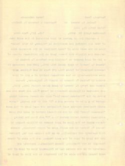
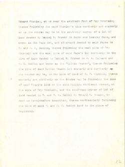
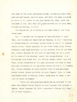
Edward Stanley, at or near the southern foot of Dry Mountain;
thence following the said Stanley's line northerly and easterly
or as the course may be to the southwest corner of a lot of
land deeded by Daniel W. Brewer to Aaron and Leander Page, and
known as the Page lot, and afterward deeded by said Pages to
F. and S. H, Rodick; thence following the east side of Dry
Mountain and the west line of said Page's lot northerly to the
line of land deeded by Daniel W. Brewer to A. A. Hayward and
W. E. Rodick and known as the "Little Meadow"; thence following
the line of said Little Meadow Lot westerly and northerly as
the course may be, to the line of land of A. F. Higgins; thence
westerly and northerly as the course may be following the line
of said Higgins land to the said Higgins northwest corner; at
the side of Dry Mountain, and the southwest corner of lot of
land deeded to F. and S. H. Rodick by Edward L. Brewer, by
deed as hereinbefore described; thence northwesterly following
the line of said F. and S. H. Rodick land to the place of
beginning.
12
to toof salt TESH TO ts
Viretase bats enti alysimet? bise gift antwollog earredt
to JOL £ to 797700 Jaewitupa gilt of ed year 987000 gift as TO
brus ,932.89 rebased bits noneA of 19W978 I'll Isiast Ed bebseb breas
of 893£9 bise vd bebeeh biswieths hrts edor 9389 sit 86 mwarr
EYA to ebis tass gdt galwoffor gonerlt ,H .P. has .
gift of JOI 2'9769 bisa to enfi Jasw silt bms
bris brswysh AAA of TOW9TH W IsthsT vd bobesh bms1 to shill
gatwoffot "wobash OCIFES" and as award brus dolboh .G .#
as vireition bets firefeew JoJ wobseM bise to enti ent
sonedia ;anig3th ..I .A to 5081 to gall add of ,so V.M.M Saxwoo grft
snif glij gatwoffot ed Samps gift as Virgition bills
JB Jaswation and bisa griff of bref anigatH hise to
to joi to Tentor JaswAJuoe ext brus EIT to shia gilf
vd ,TOWSYE ..I brawbH vs Mothof brus .7 of bebeeb basi
gatwollot somedi error as bach
to old of basi Notbog HH .3 bris .T bisa to smil and
mahmaged
£l
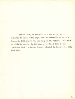
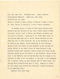
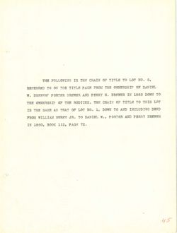
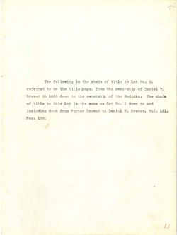
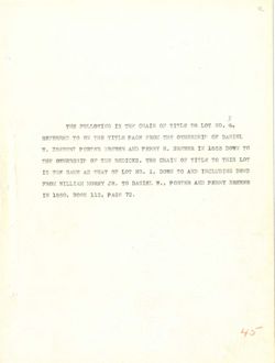
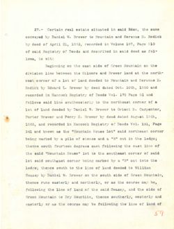
The following is the chain of title to Lot No. 2,
referred to on the title page, from the ownership of Daniel W.
Brewer in 1869 down to the ownership of the Rodicks. The chain
of title to this lot is the same as Lot No. 1 down to and
including deed from Porter Brewer to Daniel W. Brewer, Vol. 131,
Page 160.
13
$ 8.07 to abstic ent 81 relwollor SAT
... Laiged to Maneawa eds more 12843 Bill no of battolet
alano err ed! 30 - 03 1000 2081 al
of owon i .5% 103 as out al tol abrid of 61513 to
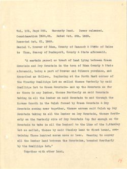
Date
5389
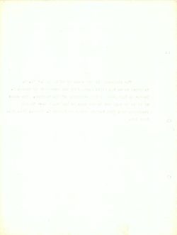
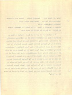
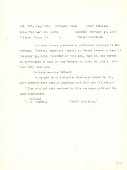
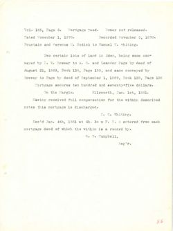
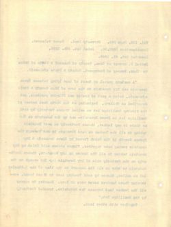
Vol. 135, Page 269. Warranty Deed. Dower released.
Consideration $500.00.
Dated Oct. 6th. 1869.
Recorded Oct. 21, 1869.
Daniel W. Brewer of Eden, County of Hancock & State of Maine
to Thos. Swazey of Bucksport, County & State aforesaid.
"A certain parcel or tract of land lying between Green
Mountain and Dry Mountain in the town of Eden County & State
aforesaid, being a part of Brewer and Gilmore purchase, and
described as follows, Beginning at the North East corner of
the Timothy Smallidge Lot so called thence Westerly by said
Smallidge Lot to Green Mountain- and up the Mountain so far
as there is any lumber, thence Northerly on said Mountain
taking in all the lumber on said Mountain to and through the
Spruce Growth in the Gulch formed by Green Mountain & Dry
Mountain coming near together, thence across said Gulch up Dry
Mountain taking in all the Lumber on Dry Mountain, thence South-
erly on the Westerly side of Dry Mountain (up far enough on the
Mountain to take in all the Lumber) to the line of the E.Stanley
Lot so called, thence by said Stanley land to first bound, con-
taining Three hundred acres more or less. Meaning to convey
all the Lumber land between the Mountains, bounded Southerly
by the Smallidge Lot."
Together with other land.
14
Iewol .heel STISTISW .eas 9389 ,881 .foV
.008£ .too betsa .00.008$
.008£ ,IS .too bebrooeA
erral to 2 food to to rewerk .W LeimeC
stets & ,Trogaxord to .sont of
moowted 34175 to JOSIJ IO ISOTSQ Mistino A"
ejete $ no.52 to not edt at EIC has
bas STOMED 5118 toweth to +ISI s gated
to IONTOO test A ent ts gatentged ,awoflof as beditoach
fitsa rd ViretseW eonent belIss 08 to TatomET edt
IBP oa aratissoM edf qss 5.00 -Mistroom of JOI
mistaroM biss NO sement , Tedmer TAB at STONE as
edit of stattroM hisa NO and IIs at gabast
EIC 8 mistmoom MOOID gd henrot do No edt st ditwort
VIA q.or doInt hisa BROTOS essent ,redtegot ISON gatmoo nistroreM
senset EIC NO redness edit IIS It galast afatroom
edt 00 dgrone Ist qur) aretroom EIC to ebta ViretaeW edit NO EITO
edt to enti edt of (redermI edt IIs at exast of alstasoM
-100 ,hawod tarli of bital relista 5188 Ed somedt , 5eliss 08 for
of gabaseM .886£ TO STON 20158 berbard 99TdT gainest
Virention& behavod meewsed redmort edt IIB
".JOI eghtfism& ent yd
,BISI Indto Nti Tentegot
PI
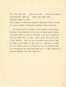
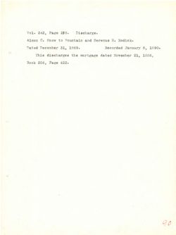
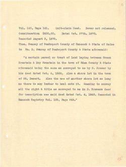
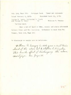
Vol. 143, Page 141.
Quit-claim Deed.
Dower not released.
Consideration $600.00.
Dated Oct. 27th. 1870.
Recorded August 3, 1872.
Thos. Swazey of Bucksport County of Hancock & State of Maine
to Wm. D. Swazey of Bucksport County & State aforesaid:
"A certain parcel or tract of land laying between Green
Mountain & Dry Mountain in the town of Eden County & State
aforesaid being the same as conveyed to me by D. Brewer by
his deed dated Oct. 6, 1869. Also & shore lot in the town
of Mt. Desert. Also the use of another shore lot so long
as there is any lumber to haul onto it. Meaning to convey
all the right & title as conveyed to me in D. Brewers deed
for description see said deed dated Oct. 6, 1869. Recorded in
Hancock Registry Vol. 135, Page 269."
15
.bessefet for IOWOI .b9e€ mlsfo-stup .IAI 9389 ,SDI .foV
.0981 .too betsl .00.00a$ moltstebtamo
.ST8£ ,8 targra bebroool
enisM to stete & fooonaH to to .aodT
:bfsaetofs 97842 s to yeasw3 .C of
COSTO moowted galvel basf to JOSIT TO I nisties A"
edsta s to awot edt at EXC S alstanoM
td TOWSTE .A Ed en of as emise edd gated blamstots
awast ent at tol eroda s oala .088£ ea .too botsb beeb atd
3000 08 JoE eroda tedtors to san edt OBLA .treaed .M to
TOTAL of gataseM .tt otao Ired of I yrs at exent as
beeb STOWEI& .0 at em of 88 9IJIT of tagti edt Ifs
at bobroook .eaar ,a .#50 betsh beeb 5tsa 608 nottqfroae.b rot
".eas eget ,881 .SOV *****
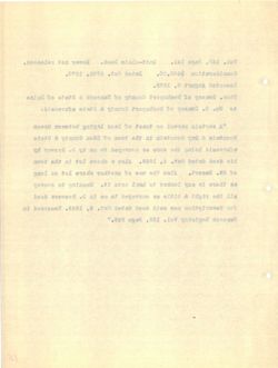
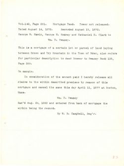
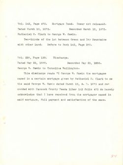
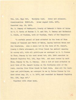
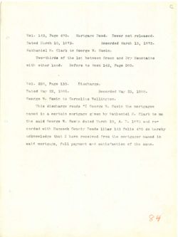
Vol. 142, Page 260.
Warranty Deed.
Dower not released.
Consideration
$3500.00. Dated August 14th. 1872.
Recorded Aug. 15, 1872.
Wm. D. Swazey of Bucksport, County of Hancock & State of Maine
to G. W. Sawin of Nashua N. H. and Geo. E. Seavey and Nathaniel
H. Clark, of Windham, both of Windham, State of New Hampshire:
"A certain parcel of land situated in the town of Eden
County of Hancock and State of Maine, laying between Green and
Dry Mountains. Also a shore lot in the town of Mt. Desert,
County & State aforesaid, at Otter Creek (so called) meaning
to convey all, with all privileges as conveyed by D. W. Brewer
to Thos. Swazey by his deed dated Oct. 6th. 1869 recorded in
Hancock Registry Vol. 135, Page 269. And same deeded by said
Thos. Swazey to Wm. D. Swazey. Also a lot of land situated in
said town of Mt. Desert laying on the Northerly side of the
road, running from Otter Creek to Seal Cove. Also all the land-
ings and privileges, as conveyed to me by Porter Brewer by his
deed dated Aug. 13, A. D. 1870, and recorded in Hancock Registry
Vol. 136, Page 447."
Together with other land.
16
.bease.ST don TOWOO .590C VOSSITSW .0as eget ,SDL .foV
Jargra betac .00.00as$ mortsxohtamo0
.898. ,as .gss bebroook
saleil to state s dooonsH to to Kesewa a
bhs yevse& .H .000 bits .H .II smiasil to alwe& .W.0 of
:exhieqmsH well to otata ,MINNEW to atod to ,HIBID .H
mobi to awat edt at betant to 5088 to I ataties A"
bas HOSTO neewead griver enter to etets bas MooonsH to
.JM to awot ent at JOL error S oala TIC
grinsen (bellso oa) NOOID TOTTO to ,hisaotota esta s
TOWSTE .W .(I Ed as IIs dttw ,Ifs of
at bebroo9t 0081 .rta ,Joo betsb beeb atd gd 898.8W8 .sont of
bisa vd bebseb easa 5 .eas 0384 ,881 .foV Extatgor foom
at betant ta base to tol s oalA .C of Tesaw& .sodT
gdt to ebla edit NO galysi treast . to awat bise
-has edt Ifa .0V00 Iso& of MOSTO Tetto mort ,beor
aid Ed TOWSTE rd em of Devevoro 8B has agal
Extaiger at bebrooot has .0481 .A.A ,EI .8VA betsb beeb
STAA 9881 ,AEL .foV
Tedto dtit sentegoT
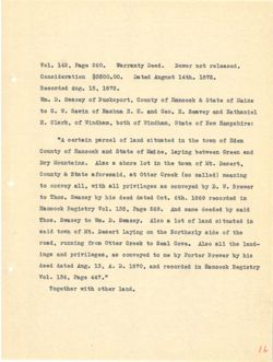
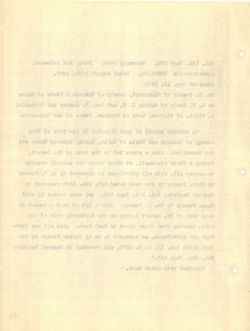
Vol. 143, Page 471.
Quit - claim Deed.
Dower not released.
Consideration $2000.00. Dated March 10 1873.
Recorded March 13, 1873.
Geo. W. Sawin of Mt. Desert in the County of Hancock,
& State of Maine, to Nathaniel H. Clark of Mt. Desert afore-
said:
"One third part of a certain tract of land situated
in Eden, County & State aforesaid laying between Green &
Dog Mountains."
Together with other land.
17
beaselet ton IOWOQ
.beel
..YYA syst ,EDI .IoV
.8181 or doraM betsC .00.000S$
.8781 ,EL doraM
NooomaH to ent st. .JII to rtwea .W .007
-orots trese([ ,JM to .H Letteritall of centsM to &
:blan
betentia his to tost aistico a to JIBq Stiff en0"
S NOOTH neewted griver blasstots state s ,neba it
". antatasom goll
.hasr testo dtiw
rl
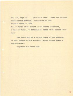
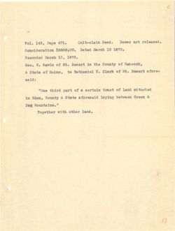
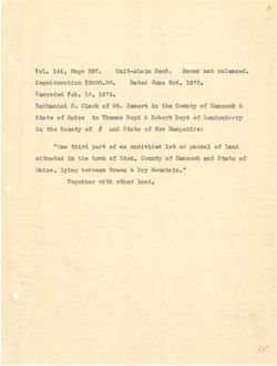
Vol. 146, Page 387.
Quit-claim Deed.
Dower not released.
Consideration $3000.00.
Dated June 3rd. 1873.
Recorded Feb. 12, 1874.
Nathaniel H. Clark of Mt. Desert in the County of Hancock &
State of Maine to Thomas Boyd & Robert Boyd of Londonderry
in the County of # and State of New Hampshire:
"One third part of an undivided lot or parcel of land
situated in the town of Eden, County of Hancock and State of
Maine, lying between Green & Dry Mountain."
Together with other land.
18
.heaseLet for TOWOO .heel .Yee 9388 ,ADE .foV
ESSE excet 50+su .00.0008$ mottstehramo
,AP8, ,SI .del
S NoodasH to edt It treael .tM to .H
to 580 ₫ tredor & byod asmont of ontell to state
:extdaqmaH well to etets has # to edt at
hms1 to Isoreg TO JOI N.B to JISq bridt 9110"
to steta Bire to ,110.53 to awat Gdt at botentia
EXC S MOOIO neeweed grifts extell
todto djtw tedtegoT
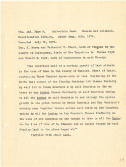
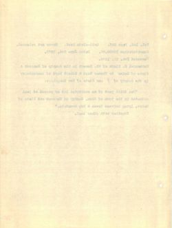
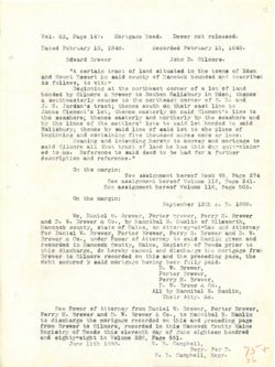
Vol. 163, Page 9.
Quit-claim Deed.
Dowers not released.
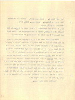
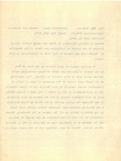
Consideration $689.00. Dated Jany. 26th. 1878.
Recorded July 15, 1878.
Geo. E. Seavy and Nathaniel H. Clark, both of Winsham in the
County of Rockingham, State of New Hampshire to Thomas Boyd
and Robert W. Boyd, both of Londonderry in said County:
"One undivided half of a certain parcel of land situate
in the town of Eden in the County of Hancock, State of Maine,
containing Three Hundred Acres more or less Beginning at the
North East corner of the Timothy Smeledge lot thence Westerly
by said lot to Green Mountain & up said Mountain so far as
there is any lumber thence Northerly on said Mountain taking
in all the lumber on said Mountain to and through the spruce
growth in the gulch formed by Green Mountain and Dry Mountain's
running near together thence across said Gulch up Dry Mountain
taking in all the lumber on dry Mountain thence Southerly on
the side of Dry Mountain up far enough to take in all the lumber
to the line of line of E. Stanley lot so called thence by said
Stanley land to the place began at."
Together with other land.
19
. ton .h99{ i.e 9389 ,801 .IoV
.8781 enjas VIST betsl .00.08a
.8181 ,àr VIST
edt set madamPW to Afod ,HISIO .H has EVER .II .09D
560 asmonT of extraqmsH well to state to
bisa at to djod .W tredoR bys
etentia bms[ to I99I8q S to 41sd bebtvthou 9000
' entsM to otsta ,NooonsH to edt at to awof edt st
edt ts gathaige aaol TO OTOM BOTOA gatatstnoo
ViretaeW Jof EdutomET ent to TOATOO task
as 1st 08 Biss I.V & aration of tol 5188 Ed
grifts 5188 no VIrentroll TAS at exedt
SOUTHE add digrount has of bisa TO today.C edit IIs at
a'mistasoli EIC has HearD rd benrior dolog out at Iftwork
EIC qss dolor brea 830I08 Tertegot IBOA gatrour
NO comerit xtathroM EID IIO edt Ifs It gablet
redness edt IIs at 91st of dgmons Ist qss EXA to ebra edd
51se Ed essent beli89 08 JOI Telesta . to extr to enil edit of
".JB reged SOBIC edit of bmsI Telnets
redto NJEW TedtegoT
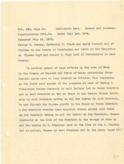
Vol. 163, Page 10.
Quit-claim Deed.
Dowers not released.
Consideration $375.00.
Dated July 1st. 1878.
Recorded July 15, 1878.
George E. Seavey, Nathaniel H. Clark and David Crowell all of
Windham in the County of Rockingham and State of New Hampshire
to Thomas Boyd and Robert W. Boyd both of Londonderry in said
County:
"A certain parcel of land situate in the town of Eden
in the County of Hancock and State of Maine containing three
hundred acres more or less bounded as follows, Viz: Beginning
at the South east corner of the premises at land of Hadley &
Richardson thence Westerly by said Hadleys lot to Green Mountain
and up said Mountain so far as there is any lumber thence North-
erly by said Mountain taking in all the lumber on said Mountain,
to and through the Spruce growth in the Gulch by Green Mountain
& Dry Mountain running near together thence across said Gulch
up Dry Mountain taking in all the lumber on Dry Mountain, thence
Southerly on the side of Dry Mountain up far enough to take in
all the lumber to E. Stanleys land or the line of the E. Stanley
lot so called, thence by said Stanleys lot to the place began at."
20
boaseler for STOWO
.beel misle-JING
.01 9381 ,800 .IOV
.898£ ,JaI T.Cort bats( .00. mortstebrano0
.878£ ,ar FISST
to IIB II9WOII htvst has XIEID .H stevee& .X 931090
well to esta 5ms madgatoon to edt ssp
biss it to afted STOE .W JIedoR has BEOE asmodi of
to mwat edt at brea to footeg A"
entall to state Bise 1000msH to edt at
grimatize& istV ,awoffor as bohard 839I IO 9TOM BOTOS berbard
& tofber to ts seatmert enf to TOTTOO tase dtvod edt ts
MODID of JOI 8Y9IhsH bise Ed Viretael essent
-AJION asset EAS at exedt as x82 08 mistasom blea qsr his
hise no redmor edt, IIS It gabiet atatasoM hisa gd tixo
statissoM to doInt edt st dtwors enrige edt dgroidt 5rs of
dolno bise 880103 soned tedJegos T60ff gathers VXI s
a EIC NO tedmor sut Ifs at gabist nistroom EIC q.r
at exas of ngrrome Ist q55 nistarom gre to obta edj IIO
Telmete .& edt to outf edt TO burl . of ent Ifs
11 ts asged 998Lg ent of JoL aveInsta bise Ed earredt ,beliss 08 JoI
06
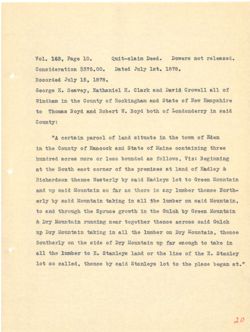
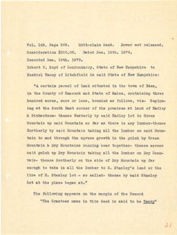
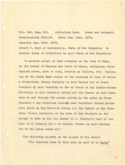
Vol. 168, Page 209.
Quit-claim Deed.
Dower not released.
Consideration $300.00.
Dated Dec. 16th. 1879.
Recorded Dec. 19th. 1879.
Robert W. Boyd of Londondarry, State of New Hampshire to
Ezekiel Taney of Litchfield in said State of New Hampshire:
"A certain parcel of land situated in the town of Eden,
in the County of Hancock and State of Maine, containing three
hundred acres, more or less, bounded as follows, viz- Beginn-
ing at the South East corner of the premises at land of Hadley
& Richardson- thence Westerly by said Hadley lot to Green
Mountain up said Mountain so far as there is any lumber-thence
Northerly by said Mountain taking all the lumber on said Moun-
tain to and through the spruce growth in the gulch by Green
Mountain & Dry Mountains running near together- thence across
said gulch up Dry Mountain taking all the lumber on Dry Moun-
tain- thence Southerly on the side of Dry Mountain up far
enough to take in all the lumber to E. Stanley's land or the
line of E. Stanley lot - so called- thence by said Stanley
Lot at the place began at."
The following appears on the margin of the Record
"The Grantees name in this deed is said to be Tandy"
21
bease.or for rewol .beel .eos egst ,88I .LoV
0T8I .990 betsC .00.008₫ moitstobiano0
.898£ order .00€ bebtooo%
of well to etata to BEOE .VV dredo
well to state 5tsa at to VOIST
to awot ent sep betamfba bast to for abstree A"
serdt greatstnoo ,9atsM to bre 1000ABH to edt at
-aiv ,awaliot as behavod ,289£ TO STODE berbard
TofbeH to basi ts dealmert edt to TOMYOO task edit to 341
ASSID of tol T9I58H btsa Ed VITSTROW sonedt -roabradors s
VAS at event as THI 08 alstrum bisa qv
-arroll blas no redeer edt IIs gabist blea gd
gd doling edit at dtworg eosiga add diground bate of rist
asoros essent Isea grimaure entation VIC & statesom
escroll EIC No Tedmur ext IIB gablet EXC qv do ing bise
ret q.5 mtetitroli ETC to obts ert no concert -niet
edit TO bms alveInafa .3 of reduct edt IIs st exes of
gelests bisa ¥d -belI80 08 - tol .₫ to eatt
".ts ragged essig edt ts toI
edt to nightm ent no galwoIfof edT
"These ed of 5188 81 boob atdt at edT"
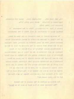
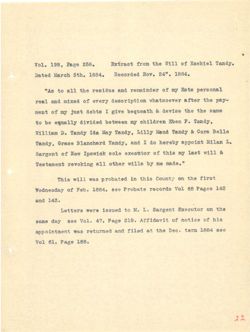
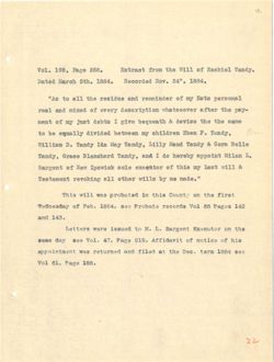
Vol. 198, Page 258.
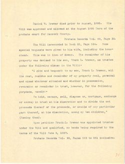
Extract from the Will of Ezekiel Tandy.
Dated March 5th. 1884.
Recorded Nov. 24" 1884.
"As to all the residue and remainder of my Ests personal
real and mixed of every description whatsoever after the pay-
ment of my just debts I give bequeath & devise the the same
to be equally divided between my children Eben F. Tandy,
William D. Tandy Ida May Tandy, Lilly Maud Tandy & Cora Belle
Tandy, Grace Blanchard Tandy, and I do hereby appoint Milan L.
Sargent of New Ipswick sole executor of this my last will &
Testament revoking all other wills by me made."
This will was probated in this County on the first
Wednesday of Feb. 1884, see Probate records Vol 68 Pages 142
and 143.
Letters were issued to M. L. Sargent Executor on the
same day see Vol. 47, Page 219. Affidavit of notice of his
appointment was returned and filed at the Dec. term 1884 see
Vol 61, Page 188.
22
IelNesH to IIEW edt MOTH
.888 9389 ,88£ .LoV
A881 ""SS . .voll bebroool
.488.£ site dozel bets(I
Ismoareq atall you to hrts outblaet ent Ifs of eA"
-VSq edt retts reveoutsdw moltqtroae.b VISTO to box m bas Isor
ames edt edt salveb & itseysed evig I add9h test you to from
that .I red# For neewed bebtvib plismpe ed of
elis& STOO & board VIINI ,Thret yes shI these .A MAILIN
.I Edored oh I bre ,EhreT 008ID "thres"
of Iftw Jasi TM aint to ToJfooxe eIoa MolwaqI well to
".eham em rd alliw tedto IIB gablover tremstasT
jarfy ent no aids at bejedorq SSW fliw aint
SAI 80389 88 IOV 8090087 efedor9 998 .4881 .do to yebsenbeW
.EAI bas
ent no TOJNO9XH .I .M of betterf grew steffed
old to softon to jtvsblr2a .OIS 9389 ,PA .IoV 992 ys5 emsa
988 ₽881 miet .990 edj to belit bms beneuter asw
.881 8389 ,18 LoV
LL
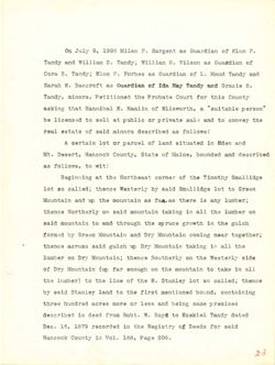
On July 9, 1996 Milan F. Sargent as Guardian of Elon F.
Tandy and William D. Tandy; William H. Wilson as Gua#dian of
Cora B. Tandy; Elon F. Forbes as Guardian of L. Maud Tandy and
Sarah E. Bancroft as Guardian of Ida May Tandy and Gracie B.
Tandy, minors, Petitioned the Probate Court for this County
asking that Hannibal E. Hamlin of Ellsworth, a "suitable person"
be licensed to sell at public or private sale and to convey the
real estate of said minors described as follows:
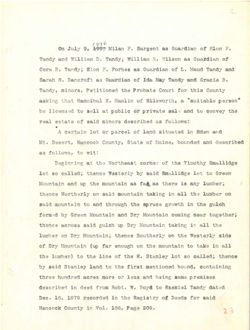
A certain lot or parcel of land situated in Eden and
Mt. Desert, Hancock County, State of Maine, bounded and described
as follows, to wit:
Beginning at the Northeast corner of the Timothy Smallidge
lot so called; thence Westerly by said Smallidge lot to Green
Mountain and up the mountain as fa as there is any lumber;
thence Northerly on said mountain taking in all the lumber on
said mountain to and through the spruce growth in the gulch
formed by Green Mountain and Dry Mountain coming near together;
thence across said gulch up Dry Mountain taking in all the
lumber on Dry Mountain; thence Southerly on the Westerly side
of Dry Mountain (up far enough on the mountain to take in all
the lumber) to the line of the E. Stanley lot so called; thence
by said Stanley land to the first mentioned bound, containing
three hundred acres more or less and being same premises
described in deed from Robt. W. Boyd to Ezekiel Tandy dated
Dec. 16, 1879 recorded in the Registry of Deeds for said
Hancock County in Vol. 168, Page 209.
2.3
.
DOI'R to an inegree . AMITN 899£ it SING as
to on MILITY adidas $ .0 Bos ybsst
has threat tessis ... to a.m 2003 . nose Hybnet .8 8200
F 810990 box vomeT her ebt 10 on as 32090083 .
ally 907 down edudent ent beneffice 9 eybrest
In Inner term paides
certified as bra JAC 20 bilding to II a of beensoff ed
: the bedProseb stone Disa In STATES lest
best 1988 boat to Testing 20 00 A
hau behavid content I experience / struced JM
titu
art 30 TIMES
the orbit MF binding boness 361
start or box nintouaM
£10 secretari 310 J the no spound
RoIn one of damage and basics alamy Nine
terms palmos ... hos and of
150 . LTC qu Plan center
9520 20 the no redege
60 suit 100 resour 4.69 me claims 120 to
chelled 001 to or and
hand Demolthem ent of Does Disa vd
with wated free arou ceros senio
between Mark 03 byof . most Special
fisa the and 41 befores RTHI 151 ....
.00S east $801
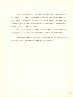
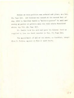
Notice on this petition was ordered and given, see Vol.
64, Page 116. and License was issued on the second Wed. of
Aug. 1886 to Hannibal Hamlin a "suitable person" to sell and
convey at public or private sale the real estate described
above, see Vol. 43, Page 557.
Mr. Hamlin took the oath and gave the License Bond as
required by law, see bond recorded in Vol. 67, Page 343.
The appointment of all of the above, as Guardian, except
Elon F. Forbes, appear on file in said Court.
24
.8851 STS ribrusk Debrose%
8881
,SL
del be etal
Isang mallion gd byof asmonT
a
of
dolow 20 moldgrossb ent Bas 000000 ni
of ess egst ,881 2008 TO 1800 8£ emse edt et
obem 8.6W sogeneter .01 9389 .80£ 1006 01 has beep retrive
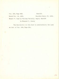
Vol. 199, Page 353.
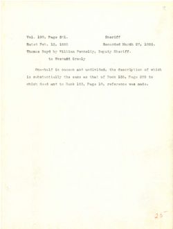
Sheriff.
Dated Feb. 12, 1885.
Recorded March 27, 1885.
Robert W. Boyd by William Fennelly, Deputy Sheriff
to Everard H. Greely
The description in this deed is substantially the same
as that of Vol. 199, Page 361.
26
888
,291
.IOV
8881
.de%
beter
Vitarge Mise 097 you byos . stedok
CLANIC
DravevE
of
redua at best alms at ent
.188
6369
to
Justif
as
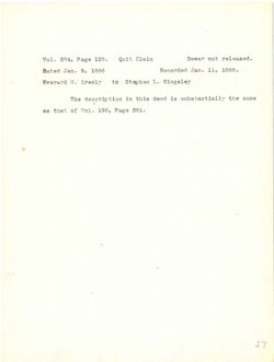
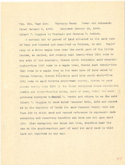
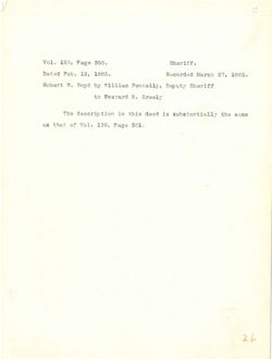
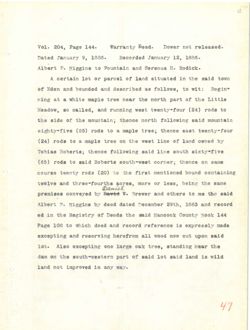
Vol. 204, Page 128.
Quit Claim
Dower not released.
Dated Jan. 9, 1886
Recorded Jan. 11, 1886.
Everard H. Greely to Stephen L. Kingsley
The description in this deed is substantially the same
as that of Vol. 199, Page 361.
27
besseler for TOWOC
388£ ,II .net
8881 is .net betch
relagn1} .I of
viewed
:
ETSTEVH
6008 erid at been ald al enT
133
to
as
T.S
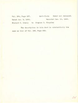
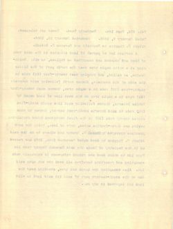
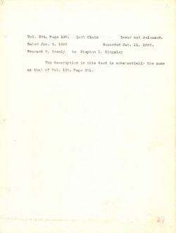
Vol. 204, Page 127.
Quit-Claim
Dower not released.
Dated Jan. 9, 1886,
Recorded Jan. 11, 1886.
Everard H. Greely
to Stephen L. Kingsley
The description in this deed is substantially the
same as that of Vol. 199, Page 353.
28
beautIer
too
.TSI legaTions.for
088£ mst behroseA
8881 if .GST beted
gelaggiX ..I nadged of .H
end of Beek ald of policesses and
.888 2001 JoV to 6.8
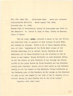
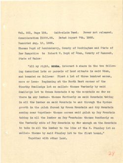
Vol. 201, Page 156.
Quit-claim Deed.
Dower not released.
Consideration $1000.00. Dated August 7th. 1885.
Recorded Aug. 12, 1885.
Thomas Boyd of Londonderry, County of Rockingham and State of
New Hampshire to Robert W. Boyd of Eden, County of Hancock,
State of Maine:
"All my right, , interest & share in the two follow-
ing described lots or parcels of land situate in said Eden,
and bounded as follows: First A lot of three hundred acres,
more or less- Beginning at the North East corner of the
Timothy Smalledge lot so called- thence Westerly by said
Smalledge lot to Green Mountain & up the mountain so far as
there is any lumber- thence Northerly on said Mountain taking
in all the lumber on said Mountain to and through the Spruce
growth in the gulch formed by Green Mountain and dry Mountain
coming near together- thence across said gulch up Dry Mountain
taking in all the lumber on Dry Mountain- thence Southerly on
the Westerly side of Dry Mountain up far enough on the Mountain
to take in all the lumber to the line of the E. Stanley lot so
called- thence by said Stanley lot to the first bound."
Together with other land.
29
Beasefer for Iewol .bee( 9389 LOS .IOV
.888I bets( .00.000[$ moitstebtano0
.8881 ,SI .3SS babrooef
to has to to 5708 asmodt
,MoositeH to to STOC .W jiedo of 91fdaqmsH well
: to
-woffot own edit at error & taste#nt you IIA"
,195 blsa at etertis brea to TO atol hedrroash got
80108 berbard SETIT to JOI A Jaril :awoIfot as behaved bms
edj to IONTOO Jask dision enf ts gatharge& -889£ TO STODY
bisa yd admedt -belise 08 JoE egholfam& EditomiT
as ISI 08 statesom gdt q.00 s 199ID of JOI agheIIsm&
grilled MistasroM bisa no edmedt -redner KIS at stent
SONIO& edit digroust 500 of bisa NO redour. edt IIB at
Alstroom VI5 5.00 atst.com KOOID Ed benrot doling edt at dtworg
EIC qss dolog 6188 BEOTOR -Tedtegot IRON gatmos
no -Mistnum EIC no reder edt IIs at grifist
aretaroli edt NO digrome Ist qrs EIC 10 ebte EffetaeW edt
08 JOI .II edt to emil edt of redmor. enf IIs sit exst of
tarth est of tol yelnet& bise yd assent -beliee
.bner redto dtiw TentegoT
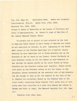
Vol. 203, Page 33.
Quit-claim Deed.
Dower not released.
Consideration $10.00. Dated Octo. 13th. 1885.
Recorded Oct. 26th. 1885.
George W. Sawin of Watertown in the County of Middlesex and
State of Massachusetts, to Robert W. Boyd of the Town of
Mt. Desert Hancock County, Maine.
"A certain lot or parcel of land situated in the town
of Eden and Mount Desert in said County of Hancock and bound-
ed and described as follows, to wit: Beginning at the North
East corner of the Timothy Smallidge lot so-called; thence
Westerly by said Smallidge lot to Green Mountain and up the
Mountain so far as there is any lumber; thence Northerly on
said Mountain taking in all the lumber on said Mountain to
and through the spruce growth in the gulch formed by Green
Mountain and Dry Mountain coming near together; thence across
said gulch up Dry Mountain taking in all the lumber on Dry
Mountain; thence Southerly on the westerly side of Dry Mountain
(up far enough to take in all the lumber) to the line of the
E. Stanley lot so-called; thence by the Stanley land to the
first bound; containing three hundred (300) acres more or less
Being same land described in a deed from Seavey and others to
Thomas and Robt. W. Boyd. See Hancock Registry Vol. 163, Page
10."
Together with other land.
30
beaseIer Jon tewo I beel .88 eyes ,EOS .LoV
.888£ .0J00 betsl .00.01$ moltstehfano0
.888£ .dtas .too bebrooeA
has x989f5bfM to edt it awottetsW to xtws8 .W SCIOOD
to nwoTment to 580 .W tredoR at ,atteamosaasM to ete+8
NoooneH +1989C .JM
nwot edlt at betsutta bref to I TO tol atation A"
-basod bms 1000mH to bisa at treast has 195H to
edt to gatanized :tiw of ,awoffot as bedtroaeb bas be
e :beffso-oa jof eghiffsma vitomit edt to Jask
ent qgss 5.00 MOOID of JOL blsa rd EfrotaeW
LLO LITENTION ;redmur. THE at STeNT as ISI 08 mtetawoM
of nistmall bisa MO redmor ent IIs st mtetnroM hisa
Ed benrot doIng ent set dtworg ent discroint has
280108 ;redterot ISON gainos nistasoM EIC bas
EIA no rederri sit IIs XI grinist abstacoli EIC qo dolog 5188
EIC to ebta Firetaew edt no senset
edt to enti edt of (redner edit IIs st extst of digrome IBI qrsr)
and of breat edt gd sensit JOI Velnets .H
aael to STOIT BOTOS (008) berbard SOTAL ;basod Jarty
of arento 5113 beeh S at hasf 90188 gated
938° ,801 .LoV Extatgen 998 .W otdog has
".01
bref redto djiw TerifegoT
(Wild land)
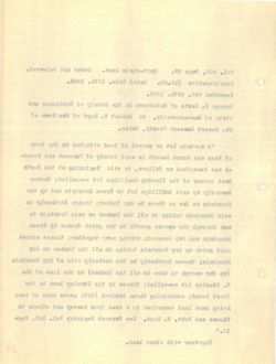
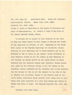
Vol. 201, Page 469.
Quit-claim Deed. Dower not released.
Consideration $1.00 &C.
Dated Nov. 10th. 1885.
Recorded Nov. 12, 1885.
Robert W. Boyd of Mount Desert, Hancock County, Maine, to
Stephen L. Kingsley of Gouldsboro, Hancock County, Maine:
"A certain lot of land situated in the Town of Eden and
Mount Desert Hancock County Maine and bounded and described as
follows to wit- Beginning at the North East corner of the
Timothy Smallage Lot so called thence Westerly by said Smallage
Lot to Green Mountain and up the Mountain so far as there is
any lumber thence Northerly on said Mountain taking in all the
lumber on said Mountain to and through the spruce growth in
the Gulch formed by Green Mountain and dry Mountain coming near
together- thence across said Gulch up dry Mountain taking in
all the lumber on dry Mountain- Thence Southerly on the West-
erly side of dry Mountain up far enough to take in all the
lumber to the line of the E. Stanley lot so called- thence by
the Stanley line to the first bound containing three hundred
acres (300) more or less, see Hancock Registry of Deeds Vol.
163, Page 10."
31
(bms) BEEW)
for
.5000 misfo-time
.00$ 0389 LOS .LoV
.888£ .NJOL .von betal
.908 00.1$
.8881 ,SL .voll bebtooeH
of ental NooonsH JavoM to byog .W jiedor
:esteM bloosesH to yefagntX .₫ medget2
has mebH to awot edit at hetentia brea to tol RISTICS A"
as bedtroaeb has belowod has ental to NooonsH +1989(I
edt to TONIOO JasH edt ts gatharge8 -tiw of awoffo2
ozeffeet& bise rd firetasW eenent beliss oa JOI egellam& Edition IT
at exedt as 1.09 or stattroM edf gss bas abstroom MOOID of Joil
edf IIs st atstriroM btsa IIO senedt rednurs VIS
at dtworg eorraga edt digrount his of mistrooM bisa no redeer
ISON nistanoM 81.5 bits MOOID Ed herror doIng gift
at griffs 8x5 qo doloo bise 880T08 soned
-taeW silt NO -atst.rom EX.5 no redard ent IIs
edt IIs at exes of digrome 1st ass MISTISSOM Ex.5 to obta Elze
rd -bellso 08 for .& edt to eath estt of redner.
berbard SATING Barrod tartt edd of omif out
.LoV abood to Extalged 1000.18H 998 ,augI TO STORI (008) BOIOB
".01 9339 ,800
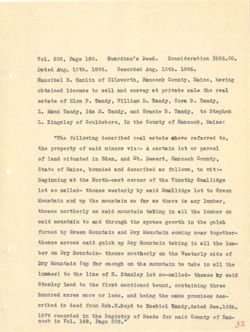
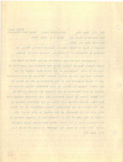
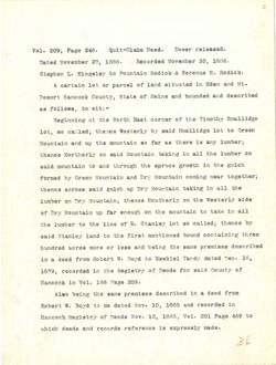
Vol. 208, Page 180. Guardian's Deed. Consideration $256.00.
Dated Aug. 12th. 1886.
Recorded Aug. 12th. 1886.
Hannibal E. Hamlin of Ellsworth, Hancock County, Maine, having
obtained license to sell and convey at private sale the real
estate of Elon F. Tandy, William D. Tandy, Cora B. Tandy,
L. Maud Tandy, Ida M. Tandy, and Gracie B. Tandy, to Stephen
Is. Kingsley of Gouldsboro, In the County of Hancock, Maine:
"The following described real estate above referred to,
the property of said minors viz:- A certain lot or parcel
of land situated in Eden, and Mt. Desert, Hancock County,
State of Maine, bounded and described as follows, to wit:-
Beginning at the North-east corner of the Timothy Smallidge
lot so called- thence westerly by said Smallidge lot to Green
Mountain and up the mountain so far as there is any lumber,
thence northerly on said mountain taking in all the lumber on
said mountain to and through the spruce growth in the gulch
formed by Green Mountain and Dry Mountain coming near together-
thence across said gulch up Dry Mountain taking in all the lum-
ber on Dry Mountain- thence southerly on the Westerly side of
Dry Mountain (up far enough on the mountain to take in all the
lumber) to the line of E. Stanley lot so-called- thence hy said
Stanley land to the first mentioned bound, containing three
hundred acres more or less, and being the same premises des-
cribed in deed from Rob.W.Boyd to Ezekiel Tandy, dated Dec.16th.
1879 recorded in the Registry of Deeds for said County of Han-
cock in Vol. 168, Page 209."
32
.00.683$ mortsrebtano0 .599{ .08£ eyeI ,80S .IoV
.088£ .NJSI bentoseA .388£ MASS
botsl
artvad to xtImsH ,I IsdinneH
ISSI edit elsa etevirq ts has Ifea of bentstdo
.8 STOO .I MALIFEW These .H mold to otstas
redgets of ,Threst 8 OLOSID bas ,Threat .M shI thret bsrall .I
: to out at to VolagafX .it
, of bottster evods etetae Isst heditoagh griwoIIo? ent"
I TO tol areties A -siv atortm bisa to edf
food ,treaed .JM bme ,119.52 at betantia basi to
-:fiw at ,awoffor as hrs behavod ,9AISM to state
ent to Textoo tase-itroll elit ts
of Jol hisa rd eonent -beliss 08 JOI
WAS at sterit as IBI 08 ristasom ent g has atstaroM
NO redent ent [Is at grifist 5tsa no Effention concert
doIng ent at ntworg ONL bre of alatmon bise
-Tentegot ISON gatmos EIC hrs MODID vd benrol
-mor ont II. at atstroom KIA Its dolors bise 880108 senset
to ohia gfretaeW ent NO eeredt EXC no red
edt LLB at east of edt IIO digrone Ist IIII) EXC
51.88 rd -bollso-oa JOI .H to enti edt of (Issaul
, 5mmod bonoffnem tarti edt of breaf
-89b seatmetq emas ent gated bms ,889 £ TO STOM 20198 Berbard
betsh, Thash feblest of bvod.w.do/ more beeb at bedtro
-IISH to bisa rot abook to VItalgeA ent at bebrooor ever
se
".ees 9381 ,8ar .LOV III 2000
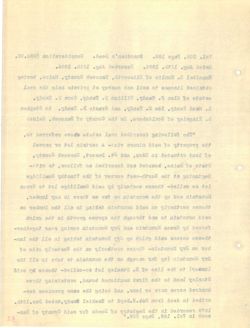
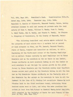
Vol. 208, Page 182,
Quit-claim Deed.
Dower not released.
Consideration $1.00.
Dated July 14th. 1886.
Recorded Aug. 12, 1886.
Milan L. Sargent of Greenville, New Hampshire, executor of the
last will and testament of Ezekiel Tandy to Stephen L. Kings-
ley of Gouldsboro, Hancock County, Maine:
"A certain lot or parcel of land situated in the towns
of Eden and Mount Desert in said County of Hancock, Bounded
and described as follows to wit:- Beginning at the North-
east corner of the Timothy Smallidge lot so-called- thence
Westerly by said Smallidge lot to Green Mountain- and up the
Mountain so far as there is any lumber. thence Northerly on
said Mountain taking in all the lumber on said Mountain to and
through the spruce growth in the gulch formed by Green Mountain
and Dry Mountain coming near together- thence across said Gulch
up Dry Mountain taking in all the lumber on Dry Mountain-thence
southerly on the westerly side of Dry Mountain: (up far enough
on the Mountain to take in all the lumber) to the line of the
E. Stanley lot so called- thence by said Stanley land to first
bound, containing three hundred acres more or less, and being
the same premises described in deed from Robt. W. Boyd to
Ezekiel Tandy aforesaid, dated Dec. 16th. 1879, recorded in
the Registry of Deeds for said Hancock County in Vol. 168,
33
for Tewo(L .5000
,S8I 9389 ,80S .LoV
.288£ .AJAE grot betsl .00.18 hottstebramo0
.888£ ,SI
ent to well to .I
-83 .I of threat IelfosH to treastest has filw teal
:enteM NOOOHBH to gol
and gdt at betantia basf to I TO joi nistico A"
behavo& ,NooomaH to KAMOO hisa at 19890 bros aebi to
-NJXON edit ts saturized -:ftw of awolloi 88 bedtroagh has
-beffso-os 935111sm& Edition T ent to TOTTOO Jass
edt I BIIR MOOIO of tol bisa rd EffetaeW
NO VITONIION sement WAS at erony as IST 08
bres of ntetaroM bisa IIO reduct out IIs at gablet blee
mistroom MOOID Vd benroi doling out st Ntwors sorrage sit dgrouds
dolor blsa 880T08 eonedt -Indtegot IBON gatmon afstasroM EXC hns
EIC NO redmor. edt IIB st subst Mistaroli BIC qss
187 EIA to obba edit no Viredtroa
edt to enti edt of (redaut edt IIs at exas of ent no
tarit of Velnets biea Td -helloo 08 tol TOINSTS .
gated bas ,889£ TO grom 89108 bethroad basod
of .W .do mort beeb at bedfroaeb 898hmelq 91188 edd
set ,ever .000 betsb ,bhsaerois Ebreat febrosE
,801 .IoV at bisa rot abeel to Extatgen edt
EE
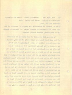
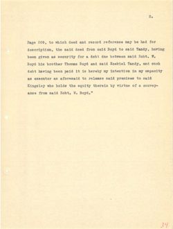
2.
Page 209, to which deed and record reference may be had for
description, the said deed from said Boyd to said Tandy, having
been given as security for a debt due between said Robt. W.
Boyd his brother Thomas Boyd and said Ezekiel Tandy, and such
debt having been paid it is hereby my intention in my capacity
as executor as aforesaid to release said premises to said
Kingsley who holds the equity therein by virtue of a convey-
ance from said Robt. W. Boyd."
34
S
IOP bad ed years 901919ICT has beeb doldw of ,eos 9389
grived ,Than biss of 580& bisa DOTT beeb bisa adt
.W .tdoll 51sa neewted estb s rot as Nevi3 need
doira Bill Sebiest bisa bas byo& asmout redtord atd 5yo&
you at you Edered at If hisa desd grived #deb
bies of seatmett bise samelor of blaastots 88 as
-Vernos a to entriv to ateredt Kttupe edt ahion odw
7.6708 .W hisa mort 950.8
, PE
Vol. 203, Page 441.
Quit-claim Deed.
Dower not released.
Consideration $250.00. Dated Jan. 15th. 1886.
Recorded Jany. 18th. 1886.
William D. Swazey of Bucksport, County of Hancock, State of
Maine to Stephen L. Kingsley of Gouldsboro, Hancock County,
Maine:
"A certain lot or parcel of land situated in the towns
of Eden and Mt. Desert in the County of Hancock, State of
Maine, bounded and described as follows to wit:- Beginning
at the North-east corner of the Timothy Smalledge lot SO-
called- thence Westerly by said Smalledge Lot to Green Moun-
tain and up the Mountain so far as there is any 1umber-thence
northerly on said Mountain taking in all the lumber on said
Mountain to and through the Spruce growth in the gulch formed
by Green Mountain and Dry Mountain coming near together-thence
across said Gulch up Dry Mountain taking in all the lumber on
Dry Mountain- thence southerly on the Westerly side of Dry
Mountain (up far enough on the Mountain to take in all the
lumber) to the line of the E. Stanley lot so-called- thence
by said Stanley land to first bound- containing three hundred
acres more or less, and being a certain lot described in deeds
Dan'l. W. Brewer to Thos. Swazey and Seavy et als. to Thos and
Robt. W. Boyd, recorded in the Registry of Deeds for said County
of Hancock, respectively in Vol. 135, Page 269 and Vol. 163,
Page 10, to which reference is made for more particular description
35
heaselet Jon ISWOC .beel misfo-JING ,IDA 0389 ,EOS ,LOV
.088£ .not betsl .00.0asa molfstebtaro0
.888£ . bebrooeA
to ,Hoooths to ,Trogexord to yeaswa .A MALLFEW
Etnoo NooonsH to Velegath .it of enter
:enteM
and edt at betentia brea to TO tol RISTIES A"
to otsta ,NoopasH To edt at dreaml .MM bys to
gatanize& -:ftw of awollo? as beditoseb has behavod
-08 JOI Vatomit odj to Tenros tase-Itton edt ts
-suroM of JOI egbellem& bisa Ed ViretaeW senout -hollso
TMS at exedt as IBP 08 mistaroM edition bas nist
bisa NO redmir. edf IIs st grint mistrum 5188 no Effection
bearrot doling sitt at dtwors ent digrount 5mg of nistarroM
IBON grimos atst.com EIC faces atstatroM NOOTD to
IIO redart ent IIs at gabist nistawoM EXA gss doIng Disa 880108
EIC to ebta Viretael end SIO essent EIC
edit II8 at elest of and no digrome Tel gir) ristasom
essent -heII80-08 tol Velasta . edt to said git of (redmi
berbard -hawod taxil of basI VeInet& blea Ed
abeeb at hodlidash tol misties 8 gated firs ,8801 TO orom 20108
511.8 BONT of .als to his Tozew& .RONT of T9W9I8 .W .I'mall
biss IOI abeeC to edjt It ,5708 .W .do
,800 .IOV blls eas 9388 ,881 .IoV XI ,NoosusH to
frottqtroae.b T8IMOIJIST 9100 rot eben at doldw of of agel
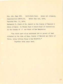
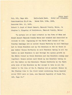
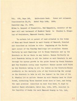
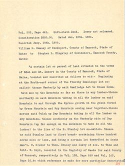
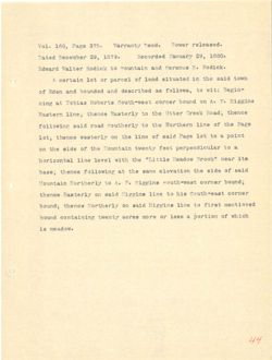
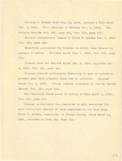
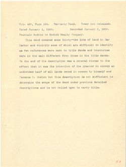
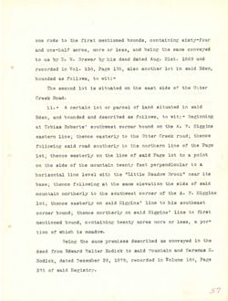
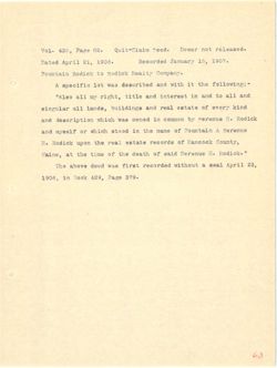
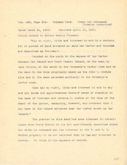
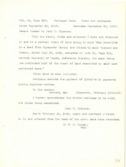
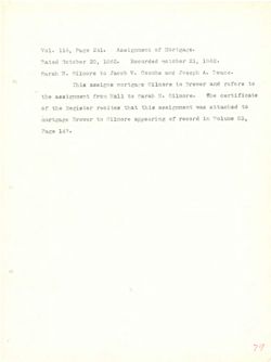
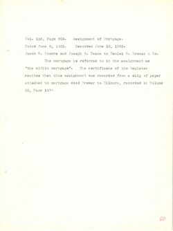
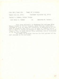
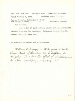
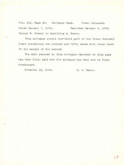
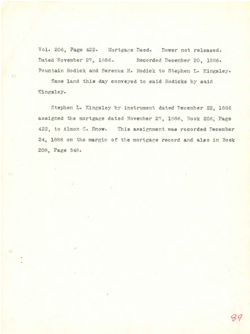
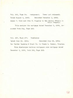
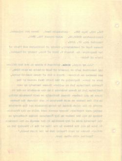
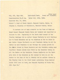
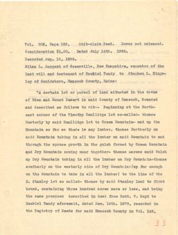
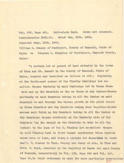
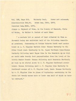
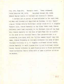
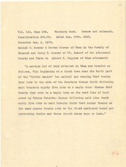
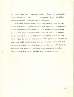
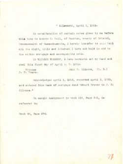
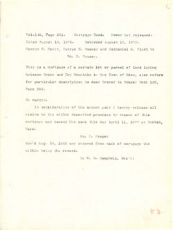
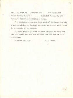
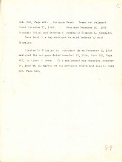
Vol. 209, Page 246. Quit-Claim Deed. Dower released.
Dated November 27, 1886.
Recorded November 30, 1886.
Stephen L. Kingsley to Fountain Rodick & Serenus H. Rodick.
A. certain lot or parcel of land situated in Eden and Mt.
Desert Hancock County, State of Maine and bounded and described
as follows, to wit:-
Beginning at the North East corner of the Timothy Smallidge
lot, so called; thence Westerly by said Smallidge lot to Green
Mountain and up the mountain so far as there is any lumber;
thence Northerly on said Mountain taking in all the lumber on
said mountain to and through the spruce growth in the gulch
formed by Green Mountain and Dry Mountain coming near together;
thence across said gulch up Dry Mountain taking in all the
lumber on Dry Mountain; thence Southerly on the Westerly side
of Dry Mountain up far enough on the mountain to take in all
the lumber to the line of E. Stanley lot so called; thence by
said Stanley land to the first mentioned bound containing three
hundred acres more or less and being the same premises described
in a deed from Robert W. Boyd to Ezekiel Tandy dated nec. 16,
1879, recorded in the Registry of Deeds for said County of
Hancock in Vol. 168 Page 209.
Also being the same premises described in a deed from
Robert W. Boyd to me dated Nov. 10, 1885 and recorded in
Hancock Registry of Deeds Nov. 12, 1885, Vol. 201 Page 469 to
which deeds and records reference is expressly made.
36
.beasefor ISWOI .bosT .AAS 93.6 L ,EOS .IoV
3881 ,08 bebroogh .8881 ,SS Tedmevor bojet
alothof of S Xolbor nistruot of velangix .I
base rebt not basautta basi to [90769 TO 40I s
badtroadb bits hobawod brus ents to 93632 doosesh
--jtw of ,awafiot as
gabilise? gilf to 10/11/09 3884 daron art J5
09970 or toi oghifism? 6168 nd ViretasW ;befier 02 ,JOI
VIIB at 979.17 as 187 08 gift qs bits distrust
no edit Ifs at bise no soneds
dolug gift at 9007q8 eit dysard bas of Mistrasom bisa
1891 301000 VIT bas (999) Vd
ext LIS set anixas atetnion VIC go dolog bise 830Y0£ gonedt
ebta gift (10 internation XXT no reders
lis ml of gift 00 YST cas VXC to
Vd sonedf balleo 08 tof .I to said edit 04 gift
servis bawoo benoffmen gitt of brief 6168
asafmery 9768 girl nated 508 aasi IO 920m 89758 berbaud
,06 .bet 593.60 thrst 02 55.08 ill dredon mc22 bash S st
to VIIIION 6188 109 aboom to SIT MT 69670097 ,ersi
.eos 99.8° 881 ,Lov ml
01017 599.5 B at out goide OBLA
st babroosy brs 8881 ,01 .VOW betsb 900 of bvo8 .W dredor
of ear 9369 LOS .LoV ,8885 ,SI .voll about to visaban
alamy VI8891qX9 at 953979197 8670597 brs abseb daida
J.E
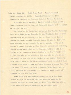
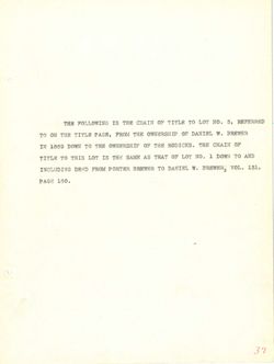
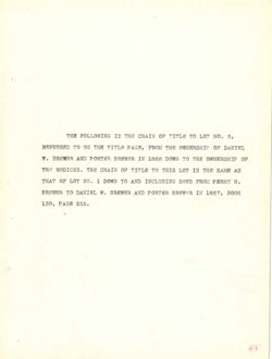
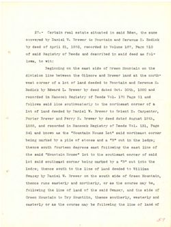
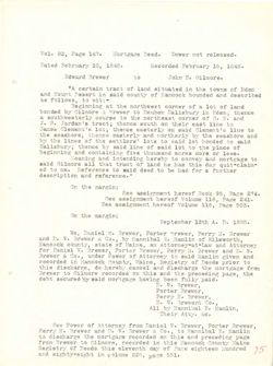
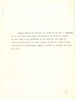
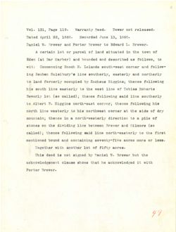
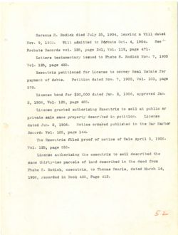
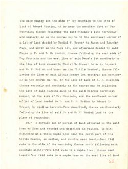
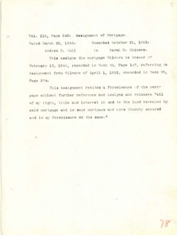
THE FOLLOWING IS THE CHAIN OF TITLE TO LOT NO. 3, REFERRED
TO ON THE TITLE PAGE, FROM THE OWNERSHIP OF DANIEL W. BREWER
IN 1869 DOWN TO THE OWNERSHIP OF THE RODICKS. THE CHAIN OF
TITLE TO THIS LOT IS THE SAME AS THAT OF LOT NO. 1 DOWN TO AND
INCLUDING DEED FROM PORTER BREWER TO DANIEL W. BREWER, VOL. 131,
PAGE 160.
37
TARASHAH
to
VIANO
HET
BI
HNT
SAMARE . Y JRIMAC 00 SHT NORS ,ROAS SINT BHT 310 07
500 MIAHO EET 500 ART OT 100 8881
CHA or KWOG I .00 700 NO TAHT SA AMAZ SHT aI TO: EIHT OT SUPIT
181 10V .W KINAG OT ARTHOR MORE
.081 MOAS
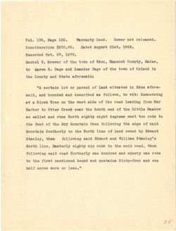
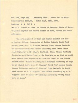
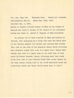
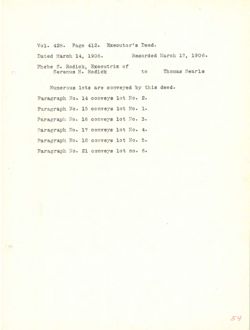
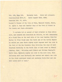
Vol. 138, Page 155.
Warranty Deed. Dower not released.
Consideration $200.00.
Dated August 21st. 1869.
Recorded Oct. 27, 1870.
Daniel W. Brewer of the town of Eden, Hancock County, Maine,
to Aaron G. Page and Leander Page of the town of Orland in
the County and State aforesaid:
"A certain lot or parcel of land situated in Eden afore-
said, and bounded and described as follows, to wit: Commencing
at a Birch Tree on the west side of the road leading from Bar
Harbor to Otter Creek near the South end of the Little Meadow
so called and runs North eighty eight degrees west ten rods to
the foot of the Dry Mountain then following the edge of said
Mountain Southerly to the North line of land owned by Edward
Stanley, then following said Edward and William Stanley's
North line, Easterly eighty six rods to the said road, then
following said road Northerly one hundred and ninety one rods
to the first mentioned bound and contains Sixty-four and one
half acres more or less."
38
for I9W0C .bee{ EUNSITSW .881 eggi ,BEI .LoV
.eaar targoA botal .00.00S$
.0V8L ,18 .too befroosH
eatsM XoooasH to awot edt to I9W9I8 .W Ielned
at haefro to awat edt to egel has 0339 .0 BOTSA of
state bas Kanoo sdj
-stote me.53 at betantia has to IDOTAq to Joi atetise A"
:J1w of awo llot as bedfroseb has behavod has ,biss
TAE mori galbael beot edj to ebta taew edf (10 BEIT dor18 8 ts
wobsell eI add to bne edt TEON Neer0 Tetto of TODTAH
of aboy net taow 8001305 date BINI bre beli80 08
bisa to 0359 edt galwoILor nedt afst.com EIC edt to tool ent
gd heawo base to outl atroll ent of
s'yelast& BRE Brawbh 5188 gatwolfog
neat ,beot biss ent at abor xia ktdgto EfretesN {
abor 910 bas bethnet erro best bisa galwoffor
ento his bas baurod benoffnee Javil edt of
",889£ IO STOCT 39108 lfsd
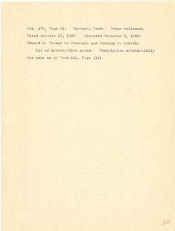
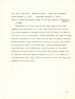
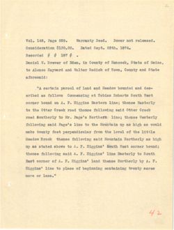
Vol. 163, Page 270. warranty Deed. Dower not .released.
Dated January 7, 1878.
Recorded November 2, 1878.
Aaron G. Page and Leander Page to Fountain Rodick & Serenus H.
Rodick.
In Eden.
Beginning at a birch tree on the west side of the road
leading from Bar Harbor to Otter Creek near the south end of
the little meadow so called; thence north 88° west ten rods to
the foot of the Dry mountain; thence following the edge of said
mountain southerly to the north line of land of Edward Stanley;
thence following said Stanley's Wm Stanley's north line easter-
ly eighty-six rods to the said road; thence following said
road northerly one hundred and ninety-one rods to the first
mentioned bounds containing sixty-four and onehalf acres more
or less and being the same conveyed to us by D. W. Brewer by
hid deed dated Aug. 21st, 1869 & recorded in Vol. 138 Page 155.
Together with other land.
39
beasefer Joss ISWOT
.beer
.Ors 93.89 ,Eal ,IOV
.8781 s redmevor bsbroosH .8981 S betsc
H s Nother atainson of 93.89 rabase.I bous 9329 .0 more.s.A
Nothor
.neb aI
bsor ent to sbba Jaew eds no DOIT dorld s JB gainnigst
to 5trs dJuoa edf 7890 ¥9979 raddo of TODYAH 788 MOTT anthasI
of abor 19 3 Jaew 988 direct ;bolies oa websem sdj
bisa to 9359 edly soment VXT ends to toot edt
brewbor to bass to Atron sity 03 nisthrom
SHILL nill alyoInsta bise somedi
bisa sonedt ;5807 bise gdt of abor VI
darit art$ of abor 5mm berbauit erro beot
STOOT 89708 have two9-vixia and aboved benefits
rd TOWSTE .V .I VII as out bevevace gmas silt gated are 2891 20
.221 syst 881 .IOV nt 13 €38£ ,JBIS gus 69386 beeb 6th
.basf rento (ttw
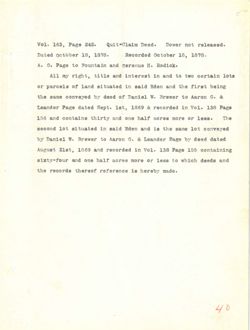
Vol. 163, Page 242.
Quit-Claim Deed.
Dower not released.
Dated October 18, 1878.
Recorded October 18, 1878.
A. G. Page to Fountain and Serenus H. Rodick.
All my right, title and interest in and to two certain lots
or parcels of land situated in said Eden and the first being
the same conveyed by deed of Daniel W. Brewer to Aaron G. &
Leander Page dated Sept. 1st, 1869 & recorded in Vol. 138 Page
156 and contains thirty and one half acres more or less. The
second lot situated in said Eden and is the same lot conveyed
by Daniel W. Brewer to Aaron G. & Leander Page by deed dated
August 21st, 1869 and recorded in Vol. 138 Page 155 containing
sixty-four and one half acres more or less to which deeds and
the records thereof reference is hereby made.
40
beasefor jon rewoo
.593T
SAS syst ,ESS ,Iov
.888£ ,81 redeted .8981 ,8£ redefen bet.,I
Solbor .H 80119792 birs of 9369 2 .A
270I mistino owj of bits ni destaunt brs 9IFIT you IIA
gaied sarit grit brts ash Disa pl batawata brai to algorey to
8.0 GOYSA of V Iglast to boob 15 bayevard other
5369 8EI .fov st babroost S 958£ ,del ,3458 botsh 976.69 rebaseJ
gift .889£ 20 910m BATOR tied 9110 his antatnoo brs aci
Deverros Jof OMAG gilt at bos debt bise at betandia tol 510096
58788 599.6 x 93.88 nit NOTEA 00 rewere W Istact
gathrathon CCI 97.69 881 .Iov ni b98T0097 6rs 828£ ,JEIS taught
5mg abseh doErw at aael TO grou 89700 91sd 9110 bris wor-vixie
ashem deter at togrend 8670597 and
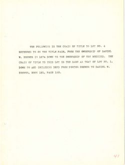
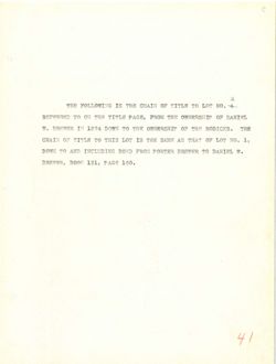
THE FOLLOWING IS THE CHAIN OF TITLE TO LOT NO. 4
REFERRED TO ON THE TITLE PAGE, FROM THE OWNERSHIP OF DANIEL
W. BREWER IN 1874 DOWN TO THE OWNERSHIP OF THE RODICKS. THE
CHAIN OF TITLE TO THIS LOT IS THE SAME AS THAT OF LOT NO. 1,
DOWN TO AND INCLUDING DEED FROM PORTER BREWER TO DANIEL W.
BREWER, BOOK 131, PAGE 160.
41
$ .0%
MARIT
80
HHT
21
OVIPORIOT
SINSHEUMO
SHT
30049
ROAS
SUPER
WITH
in
or
SHT HIP 30 RET OF www. ATPL III .W
. £
.00 80 TAHT 2A HMA2 ART 21 TOT SEAT OT BIRTH to HIAHO
. W OF REWERT 987805 MORE IRAC OPTIQUIONT OF WWOO
081
BOAT
,581
3008
ANDRES
Vol. 148, Page 559.
Warranty Deed.
Dower not released.
Consideration $130.00. Dated Sept. 25th. 1874.
Recorded # # 187 #
.
Daniel W. Brewer of Eden, in County of Hancock, State of Maine,
to Alonzo Hayward and Walter Rodick of Town, County and State
aforesaid:
"A certain parcel of land and Meadow bounded and des-
cribed as follows Commencing at Tobias Roberts South West
corner bound on A. F. Higgins Eastern line; thence Easterly
to the Otter Creek road thence following said Otter Creek
road Southerly to Mr. Page's Northern line; thence Westerly
following said Page's line to the Mountain up as high as would
make twenty feet perpendicular from the level of the little
Meadow Brook thence following said Mountain Northerly as high
up as stated above to A. F. Higgins' South West corner bound;
thence following said A. F. Higgins' line Easterly to South
East corner of A. F. Higgins' land thence Northerly by A. F.
Higgins' line to place of beginning containing twenty acres
more or less."
42
.bease.er for rewoll .609¥ EJISTISW .008 038° ,8DL .LoV
AV8I .tqs8 betsc .00.0818
t rar #
to etets ,Nooorsh to at ,000.52 to TOWOIK .W Ielned
eteja Brs ,AWOT e to Nothon refIsW Brs biswysH of
:bisserots
-seb has bennted wobsek has Erref to Looisq staties A"
tasW Atrol atredof asidot ts awo.I.of as bedtro
Viratask coment :eatf anissth .I .A no Smod
NOOTO TOTTO bisa gatwoIIof 19930 TOTTO edit of
FlisteeW :enti alogeI IM of heot
5Lsow 88 dgld as gs nistation edt of extf 8'9389 blee gatwoIIof
eIttle edt to lovel ext mort tool ktrewd salem
dalit 8B bisa 10018 woheeM
:bassed TOTTOS JeeW dtvea 'antagth .7.1 of evode betets as oper
of outs 'antasth .I .A bisa gatwoIIoI
7.1 rd Virention essent base M.A to TOTIOS #831
30103 strews to 908Iq of eath 'agtgath
".aasI IO STOCK
Vol. 168, Page 225.
Warranty Deed.
Dower not released.
Consideration $95.00.
Dated Dec. 25th. 1879.
Recorded Dec. 26th. 1879.
Alonzo A. Hayward of Eden, in the County of Hancock, State
of Maine, to Walter E. Rodick of said Eden:
" A certain lot or parcel of land situated in Eden a-
foresaid being one undivided half of the following describ-
ed premises; Commencing at Tobias Roberts South west corner
bound on A. F. Higgins Eastern line- thence Easterly to the
Otter Creek road- Southerly to Mr. Pages Northern line-thence
Westerly following said Pages line to the Mountain up as high
as would make twenty feet perpendicular from the level of the
Little Meadow Brook- thence following said Mountain Northerly
as high up as stated above to A. F. Higgins Southwest corner
bound- thence following said A. F. Higgins line Easterly to
Southeast corner of A. F. Higgins land, land- thence Northerly
by A. F. Higgins line to place of beginning- containing in the
whole lot twenty acres more or less- one half of which is here-
by conveyed.'
43
for TOWO
.booC VINSTIBW
.ass ,881 ,SoV
.0181 .dtas .09A hetsC .00.80$ softsxebiano3
.0181 ...
estate ,1000msH to and at , me.53 to biswysh .A ORNOLA
: bisa to fothof .3 retfeW of ,entaM to
-8 meBH at betentia has to Isoreq TO JOI afatioo A If
-direast galwollot ent to tien bebivibus SITO gated
TOXIDO Jaew Atro& attedor asido to ;seatment be
edt of eonedt -onis antagth . A NO harrod
agged IM of -580T Naoro Tetto
dgtd 88 q.v edt of extf aeget biss galwoIfol
edt to Level edt mort took strews exam bloom as
bisa soned -20018 wobseM
tsewdfro& antsath .X .A of avoids beteta as gss dgtN 88
of giretast onil antagth .8 .A 5188 galwoffor eegent -harrod
essent -bast anfgsth .T .A to TOTIOS
out at -galantzed to eosiq of ontI antagth .I .A gd
-979₫ et doldw to lisd SHO -ases TO GIOM SATOS strews JOE elodw
Ed
Vol. 168, Page 375. Warranty Deed. Dower released.
Dated December 29, 1879.
Recorded January 29, 1880.
Edward Walter Rodick to mountain and Serenus H. Rodick.
A certain lot or parcel of land situated in the said town
of Eden and bounded and described as follows, to wit: Begin-
ning at Tobias Roberts South-west corner bound on A. F. Higgins
Eastern line; thence Easterly to the Otter Creek Road; thence
following said road southerly to the Northern line of the Page
lot; thence westerly on the line of said Page lot to a point
on the side of the Mountain twenty feet perpendicular to a
horizontal line level with the "Little Meadow Brook" near its
base; thence following at the same elevation the side of said
Mountain Northerly to A. F. Higgins south-west corner bound;
thence Easterly on said Higgins line to his South-east corner
bound; thence Northerly on said Higgins line to first mentioned
bound containing twenty acres more or less a portion of which
is meadow.
44
beasefer Towor
-beer VINSTISW
9384 ,881 .IOV
.0881 ,es bebrooal
.8T81 ,es betst
.Notbo .11 bms mistason of 79JIGN
awas biss gdt set batautta boer to TO tos mississ A
-digst :Jtw of 86 badtroagh bys bsbrkrod bms 1995 to
entagth .7 .A no Shood 197700 Jasw-dJ.002 strodoR asidot ts gota
saneds ;beost 79330 enf of Firstast sansas mitfash
9859 sds to smil mandroll 9d$ of Virention bsor 5188 andwollog
takoq S of 9369 5.6.8 to snif edt GO X/19/897 soment 6J6I
£ 03 1999 strews missmor of to obta edj NO
asi 1697 "NOOTE wobsel GISSET" and dftw IgveI saff Introstrod
bisa to obta edf molfeveIa 9168 art ts gaiwoffe? read
;brued 190700 emingth HIA of
197700 Jaso-stude aid of enti animalis bisa no VirgJash sansaid
benofdnem jerty of said bise no Virgition senedt ;based
doldw to deliged S aasi TO STOD 89708 strewt basod
wobsem el
th
THE FOLLOWING IS THE CHAIN OF TITLE TO LOT NO. 5,
REFERRED TO ON THE TITLE PAGE FROM THE OWNERSHIP OF DANIEL
W. BREWER? PORTER BREWER AND PERRY H. BREWER IN 1863 DOWN TO
THE OWNERSHIP OF THE RODICKS. THE CHAIN OF TITLE TO THIS LOT
IS THE SAME AS THAT OF LOT NO. 1, DOWN TO AND INCLUDING DEED
FROM WILLIAM MOREY JR. TO DANIEL W., PORTER AND PERRY BREWER
IN 1860, BOOK 112, PAGE 72.
45
,6 .0% OF RETTIT EO WIAHD SHT at DATE AHT
JHIVAC TO STREARING BATT 11089 9049 RITIT 70 OT CHARRIER
or MWOO 888£ MI 850888 .H YARET CUA PHWRE ARTHOS SERVICES W
TOJ BIRT OT BIRTH go KIAND SHT 2351008 SET 80 ATRESHAWO RHT
@33C GMA OT MFGC .I .OK TOJ 50 TAHT 2A RMA 3RT 2I
74387 CKA .. JRIMAC OT FL YARDY MATRITI MORE
.ST #DA9 ,911 7008 .088£ MI
Vol. 144, Page 108.
Warranty Deed.
Dowers not released.
Consideration $90.00.
Dated Dec. 29th. 1863.
Recorded Jan. 6, 1873.
Daniel W. Brewer & Porter Brewer of Eden in the County of
Hancock and Perry H. Brewer of Mt. Desert of the aforesaid
County and State to Albert F. Higgins of Eden aforesaid:
"A certain lot of land situated in Eden and bounded as
follows, Viz: Beginning at a birch tree near the North part
of the "Little Meadow" (so called) and running West twenty
four rods to the side of the Mountain thence North following
said Mountain eighty five rods to a maple tree: thence East
twenty four rods to a maple tree on the west line of land
owned by Tobias Roberts; thence following said line South
sixty five rods to said Roberts South West corner thence on
the same course twenty rods to the first mentioned bound and
containing twelve and three fourth acres more or less."
46
.boaseIeT for arenoi .bee( KJNSTISW .80I 0389 ,API .foV
.8281 .dtes .000 betal .00.00$ moltstehlano0
.ETBI ,a .NeT bebsogeR
to edf set robE to TOWOTH TOJIOS s tow9x8 .W lettrel
htsaetota ent to JISSAC .M to 19W9I8 .H VITOC has doosnaH
:bissetote ment to enfagth .8 tredia of state Bas
88 bebrurd has re.58 at betautia to JOI A"
jrsq diroll off ISON 0015 dorld s ts gabritged :aiv ,awo L.or
ktrowt taeW has (bell80 oa) "wobseM "I edt to
gatwoIfol soment add to 9618 edit of abot INOI
Jasil : ofqsm B of abox evit stagis alsanom bies
has to sall taow out no elgam 3 of abox work strown
days onif hisa galwoIfot assest ;stredoll astdot gd bonwo
NO Tentos teell stredoR bisa of abor ov 12 poxis
has basod ent of 850% knows 08/100 91188 gilt
".aael TO 80108 earni has ovlowf
Vol. 204, Page 144.
Warranty Deed.
Dower not released.
Dated January 9, 1886.
Recorded January 12, 1886.
Albert F. Higgins to Fountain and Serenus H. Rodick.
A certain lot or parcel of land situated in the said town
of Eden and bounded and described as follows, to wit: Begin-
ning at a white maple tree near the north part of the Little
Meadow, so called, and running west twenty-four (24) rods to
the side of the mountain; thence north following said mountain
eighty-five (85) rods to a maple tree; thence east twenty-four
(24) rods to a maple tree on the west line of land owned by
Tobias Roberts; thence following said line south sixty-five
(65) rods to said Roberts south-west corner; thence on same
course twenty rods (20) to the first mentioned bound containing
twelve and three-fourths acres, more or less, being the same
premises conveyed byDaniel W. Brewer and others to me the said
Albert F. Higgins by deed dated December 29th, 1863 and record
ed in the Registry of Deeds the said Hancock County Book 144
Page 108 to which deed and record reference is expressly made
excepting and reserving herefron all wood now cut upon said
lot. Also excepting one large oak tree, standing near the
dam on the south-western part of said lot said land is wild
land not improved in any way.
47
beaugify Joss Y9W0T .699F
API 9389 ,AOS .LOV
.8881 ,SI VISUALS b9br0098
.888£ if VISUAST betst
Xoibog II hrs of . jredia
awoj bise eity at betextie bass to [90789 10 JOI alstree A
-sige& :Jiw of as badriessb brus bebaurd 5ms neby to
edt to truq Horror enf 1690 9993 sigem giftiw & ts gain
of abor (PS) Jaew grimmy bas ,beliss 08 ,wobself
bisa antwoffet diron ;nisjwon edj to sbia and
tase sontents 9997 of abor (c8)
rd banwo basi to said Jaew silt no 9975 s of abor (AS)
evil-toxie Aftica enti 6168 matwoffor sonedJ asidot
smee 00 sonorid TENTO taew- divos adx9dof bise of abor (aa)
based bonofJaem Janit gift CJ (OS) abor 987000
gasa gift gaind ,889£ TO 97001 ,HOTOS bms ovIews
bise gift 9M of argito brus .W againerq
Broost brus casr ,NICS bojsb b99.6 rd jrodia
AAI NOOT fooomsH bise and abosT to odd as bs
9.6.3m at 570087 bms boob doldw of 80£ 9729
bisa proges two won boow IIs MOTIONS SALVI989T Bas galfqeox9
ent Ised anthrasta ,997₫ NSO SATEL 900 gatjq85x9 calA .301
bftw at bnsf 6fee JOI bise to FIEq 911 no med
NEW KING ni beverami for busi
THE FOLLOWING IS THE CHAIN OF TITLE TO LOT NO. 6,
REFERRED TO ON THE TITLE PAGE, ? FROM THE OWNERSHIP OF DANIEL
W. BREWER AND PORTER BREWER IN 1868 DOWN TO THE OWNERSHIP OF
THE RODICKS. THE CHAIN OF TITLE TO THIS LOT IS THE SAME AS
THAT OF LOT NO. 1 DOWN TO AND INCLUDING DEED FROM PERRY H.
BREWER TO DANIEL W. BREWER AND PORTER BREWER IN 1867, BOOK
130, PAGE 255.
48
...
so
INIMAC
300
MORE
JOST
10
0m
@@@@@@@
20 SUITE OZ 1000 8581 MI STATES STATROS CVA
8A RMA3 9HT EI TO:1 BIRT OT CUTIC 20 LAHO ART
H YARRY KORE gave IKA or sweet 1 .02 708 no PART
4008 .8881 I.I ARTHOS CKA STREETS .V IRINAC OT
Vol. 131, Page 119. Warranty Deed. Dower not released.
Dated April 22, 1868.
Recorded June 13, 1868.
Daniel W. Brewer and Porter Brewer to Edward L. Brewer.
A certain lot or parcel of land situated in the town of
Eden (at Bar Harbor) and bounded and described as follows, to
wit: Commencing Enoch H. Lelands south-west corner and follow-
ing Reuben Salsibury's line southerly, easterly and northerly
to land formerly occupied by Zacheus Higgins; thence following
his south line easterly to the west line of Tobias Roberts
Beverly lot (so called); thence following said line southerly
to Albert F. Higgins north-east corner; thence following his
north line westerly to his northwest corner at the side of dry
mountain; thence in a north-westerly direction to a pile of
stones on the dividing line between Brewer and Gilmore (so
called) thence following said line north-easterly to the first
mentioned bound and containing seventy-five acres more or less.
Together with another lot of fifty acres.
This deed is not signed by Daniel W. Brewer but the
acknowledgement clause shows that he acknowledged it with
Porter Brewer.
49
for 19W0C .best VINSITSW ..... , EES .IOV
.858£ ,EI emit bebrossH .8881 ,SS IPIQA bater
.19W9YE .I brswh or TOWOTH 293109 brs TOWSTE I'M fainsa
to now off of betertis brsi to 19078q 20 JOI mistigo A
of ,awoflot 8.8 bed/yoagh brus babaired brus 7.88 I.).
-wollot bas 190700 Jaew - abouted .H NoonH gatorenno5 :Jfw
VIrendroa bas VireJass SHIL deduce gmt
gatwoIIoT somedt austions vd belqwooo basi 0.3
astdot to smil 1897 silf 08 sate Stuoa etd
enti bisa galwoffor concests i (belles oa) joi
afif 3niwoIfot soment 790000 antagth H JISTIA 03
VID to ebta edit JB Jaewafrom aid of Viredaew saif diron
to sftq S of s at senent
08) STOMILS bits TOWOTH neewead SMII gatbivib ent NO askoja
Jarfi sift of The - diror SMIL bise gatwollot somedy i (belino
.8891 TO STOD bru Brued
....... VIIII to JOI gertions
gdt did w Leiner VCP bengta golf ai 599.6 aint
ddkw It bogbeIworrios ed Jend aworla SENSIO
797709
PH
Vol. 175, Page 51.
Warranty Deed.
Dower released.
Dated October 30, 1880.
Recorded December 2, 1880.
Edward L. Brewer to Fountain and Serenus H. Rodick.
Lot of seventy-five acres. Description substantially
the same as in Book 131, Page 119.
50
beaseIgh rewort
.beet VINSTIEW
.18 9344 ,CEI .IOV
.0881 s rednisse babrooal .0881 ,OE redoten bojal
Nother .H brus of rewere .J 57.8wb3
Vfishjmajadra evff-vjn9v9a to toJ
.CII 93sg ,IEI 5008 nit as emsa and
oc
THE FOLLOWING IS THE CHAIN OF TITLE TO ALL THE PROPERTY
IN QUESTION FROM THE TIME OF THE OWNERSHIP OF THE RODICKS
DOWN TO THE DATE OF THIS EXAMINATION AND SHOWS THE TITLE OF
THE RODICK REALTY COMPANY TO THE SAME.
51
VTR39089
HITI
HO
RHT
RHT 40 867 30 SMIT 3HT MORE NOT MI
NO SITIT PHT aware THA VOITAVINAY all 30 TAC ART OT MWCC
OT
YEASHOO
MOTOOR
HIT
Serenus H. Rodick died July 25, 1904, leaving a Will dated
Nov. 9, 1903. Will admitted to Probate Oct. 4, 1904. See
Probate Records vol. 125, page 241; Vol. 119, page 471.
Letters testamentary issued to Phebe S. Rodick Nov. 7, 1905
Vol. 125, page 430.
Executrix petitioned for License to convey Real Estate for
payment of debts. Petition dated Nov. 7, 1905, Vol. 103, page
579.
License bond for $20,000 dated Jan. 2, 1906, approved Jan.
2, 1906, Vol. 125, page 485.
License granted authorizing Executrix to sell at public or
private sale same property described in petition.
License
dated Jan. 2, 1906. Notice ordered published in the Bar Harbor
Record. Vol. 105, page 144.
The Executrix filed proof of notice of Sale April 3, 1906.
Vol. 125, page 555.
License authorizing the executrix to sell described the
same thirty-two parcels of land described in the deed from
Phebe S. Rodick, executrix, to Thomas Searls, dated March 14,
1906, recorded in Book 428, Page 412.
52
betab 1119 & galvesi ,AOCI ,as VLVT belb dotbod .K authers?
503
.4081 if .toO 93.800.59 CJ body imbe IIIN
.60ef
st
.von
IIA 934q .IoV (IAS 9769 ,ESL - for 8670097 stedory
COCI is
.von dolboff .8 adeda ct benaei staffed
.OEA ,asf .IOV
20% stafes Issa Zevino of sansofi 209 benefitsg xirtuoex
eyeq ,80£ ,IOV ,2001 .vol batso moifitog reides to
.era
.rust bavorgas ,600£ ,S .CGST badab 000,088 70% blood
.884 9365 ,681 .IOV racef,
TO stiding JB Ilsa of bojnets samest.I
nit bedingaeb 90188 9168 gjeving
rodrest THE ent at SallatIduq benebac adel is art
batch
AAI 08.6q ,COI .IoV .650097
.8081 re LETGA to solton 26 goory belit xirtwoex ant
.866 9384 ,ESS ,ICV
gilt bad ribash Ise of eitt baneol3
mort 566.6 gilf nit bedtroaeb buss to elocated owd- string 91188
,AI doral both reftes? asmodi OF .3 adidas
SID SYNT ,85$ steb8 at bebtoost raoef
st
Vol. 426, Page 394. Warranty Deed. Dower not released.
Dated January 1, 1906.
Recorded January 2, 1906.
Fountain Rodick to Rodick Realty Company.
This deed covered some thirty-two lots of land in Bar
Harbor and vicinity some of which are difficult to identify
as few references were made to title deeds and boundaries
were in the main different from those in the title deeds.
On the end of the description was a general clause to the
effect that it was the intention of the grantor to convey an
undivided half of all lands owned in common by himself and
Serenus H. Rodick but this description is not sufficient to
determine the scope of the deed under previous detailed
descriptions and is not relied upon to carry title.
53
beassI9T joii TOWOA
.beet VINGTTSW
.ARE 9984 , BSA ,LOV
.doef is bebrooef
.80££ if VISUIST betea
VIISOA Nothof of 251508 misdewoll
7.88 at breaf to atoi emoa bash
kttjnebi of 976 doldw to émos vitaloly brs
holisbawod 5mg abseb 9LJII of absor STOW 890(1979799 wed 8.8
.8boob SIJLY and at 980HJ mort also edj st STOW
9113 0.0 SEUSIO & asw moitginoash enj to bas ent no
ris of and to moltnejal and BRW jt tedt footts
bas tleemid rd common nit bertwo abmet LIs to Aded behivinn
0.5 FOR at moisqbroash aids did XofboA HH
helisteb avoivery rebno 5996 and to 84058 911
.9LJIJ 87785 of roqu beiler ton et bms
Vol. 428. Page 412. Executor's Deed.
Dated March 14, 1906.
Recorded March 17, 1906.
Phebe S. Rodick, Executrix of
Serenus H. Rodick
to
Thomas Searls
Numerous lots are conveyed by this deed.
Paragraph No. 14 conveys lot No. 2.
Paragraph No. 15 conveys lot No. 1.
Paragraph No. 16 conveys lot No. 3.
Paragraph No. 17 conveys lot No. 4.
Paragraph No. 18 conveys lot No. 5.
Paragraph No. 21 conveys lot no. 6.
54
beeT .SIA 9369
.80ef SI dorse bebroast
.8081 ,Ad NOTE beigh
to
Molbog .? 9791.9
afree
OJ
Nothor .4 85795992
O
beeb abd rd beverage 978 aJOI avoremen
.S .OH JOS 41 .01
.I .01
JOI BYSTADO EI .011 dystisted
.E
.0 joi 31 .011 HISTRATES
JOL II .01
.C
.ON JOI 81 .07
on JOI IS .OK
Vol. 429, Page 256. Quit-Claim Deed. Dower released.
Dated March 1, 1906.
RecordedApril 19, 1906.
Thomas Searls to Rodick Realty Co.
This deed conveys numerous lots by numbered paragraphs.
Paragraph No. 8 covers the Page lot being lot No. 3.
Paragraph No. 11 covers the Edward Walter Rodick lot being lot
No. 4.
Paragraph No. 17 covers the Edward L. Brewer lot, being lot
No. 5.
Paragraph No. 27 covers the Daniel W. Brewer lot being lot No.
1.
Paragraph No. 29 COVES the Albert F. Higgins lot being lot No.
5.
Paragraph No. 32 covers the Kingsley lot being lot No. 2.
55
b9889197 rewor
best misso
.825 9789 , est .IOV
naer ,01
.8001 of dorse betst
.00
VIIseA
Nothof
of
817892 asmodi
vd etos 8197000 boob aint
.E .or for arted for 9389 and 879V09 8 .07
tol gated JOI Xolbon TOJICM brswbH gold BYSTOO II .01
+.0k
JOI gated ,301 rewere at 5qsw6H art's 879705 SI .0%
-8.0k
.OX JOI grided JOI TOW9Y . Y Istreet gift 879709 SS .0% signature
₫01
appoint
JOL
.9
and
COVOR
es
.0%
requires
. c
.S... anise JOI and 879V05 SE .oll HASTISTICT
C.
Vol. 429, Page 276. Warranty Deed. Dower not released.
Dated March 1, 1906.
Recorded April 19, 1906.
Fountain Rodick to Rodick Realty Co.
This deed conveys one-half undivided of numerous lots
of land by numbered paragraphs, the following paragraphs
touching the locus:
35.- "All other lands, and all legal or equitable inter-
est in lands situated in said Hancock County and owned in com-
mon and undivided by the said Fountain and Serenus H. Rodick
at the date of the death of the latter excepting the interest
of Fountain Rodick in Bar Island so called in Frenchman's Bay
being the Island immediately north of the village of Bar Harbor
8. - "Two certain lots or parcels of land in said Eden,
and described in the original deed from A. G. and Leander Page
to Fountain and Serenus H. Rodick dated January 7, 1878 re-
corded in Volume 163, Page 270, of said Registry as follows,
to wit:-
Beginning at a birch tree on the west side of the road
leading from Bar Harbor to Otter Creek, near the South end of
the Little Meadow so called; thence north eighty-eight degrees
west ten rods to the foot of the Dry Mountain; thence follow-
ing the edge of said Mountain southerly to the north line of
land of Edward Stanley; thence following said Stanley's Wm.
Stanley's north line easterly eighty-six rods to the said road;
thence following said road northerly one hundred and ninety-
56
Jon row beet VINSTISW .APS 9989 , ESA .IOV
3005 , es ItrqA. bebrooal
.0081 if doney
.00 Wiser Nothor of 251bof
8J0I to bash eid
notwollot grlf vod brash to
: and antiquoted
#Idsthips TO Ismal SIG bre , abref radac IIA" ⑉.08
100 at berww Sius blea of betendin abnel all JBS
. bas bisa ant vd babivihous bre nom
dearstut gift TOTTEL 911 to dissb's it to 876h and JS
you almandomen't mit belies 08 basial you of 251565 I
40dhs 78 to erit to dates Brafel add anter
ohsa at basi to alebasq TO ados ateines owT"
97189 reburse bris .0.0 more b996 Isminito 9110 ml DOS
-57 8981 is betch yofbox of brus of
,awellot as biss TO OTS grust employ ml bobres
-: 07
heer gift 20 9618 389F gift no esti don de & is
to bos Adion 1091 7:43 code THE 2017
8997395 Adron 9009 (I 08 wobse] are
-wollon soment internum you and to 9009 sild of abon Yes Jasw
to grill direct gift of bise to stibs grift got
.00W alveInst hise natwollog songrit brawbo to bread
bise and 03 aboy BireJase 9ml1 sitron a'vainsj?
one berbaudi 9110 Virgition 5607 5168 patient
one rods to the first mentioned bounds, containing sixty-four
and one-half acres, more or less, and being the same conveyed
to us by D. W. Brewer by his deed dated Aug. 21st. 1869 and
recorded in Vol. 138, Page 155, also another lot in said Eden,
bounded as follows, to wit:-
The second lot is situated on the east side of the Otter
Creek Road.
11. - A certain lot or parcel of land situated in said
Eden, and bounded and described as follows, to wit: - Beginning
at Tobias Roberts' southwest corner bound on the A. F. Higgins
eastern line; thence easterly to the Otter Creek road; thence
following said road southerly to the northern line of the Page
lot; thence westerly on the line of said Page lot to a point
on the side of the mountain twenty feet perpendicular to a
horizontal line level with the "Little Meadow Brook" near its
base; thence following at the same elevation the side of said
mountain northerly to the southwest corner of the A. F. Higgins
lot; thence easterly on said Higgins' line to his southeast
corner bound; thence northerly on said Higgins' line to first
mentioned bound, containing twenty acres more or less, a por-
tion of which is meadow.
Being the same premises described as conveyed in the
deed from Edward Walter Rodick to said Fountain and Serenus H.
Rodick, dated December 29, 1879; recorded in Volume 168, Page
375 of said Registry.
57
⑉100 ,rebt blea nt to 190784 TO to 0100790 / --SI
.H administ box 6188 03 brewhor yo beyev
55 emerov ni 69b70097 ,0881 ,OE redet50 to besb vd
6997 bise ML bad/reash and brus vodalwa? 5188 to 97.89
"welloi bre 197705 task- - 1000 abnefel ... doonH
Wrentron brus Virstase saif reduce art
gatwoIIor average vd basi 03
attedor adidas to SHIL Jaew erit 03 enil donoa ett
sail 5188 matwollo? soment (befiss 08) 001
and 1990000 tass-rifrom activities . of
urb to obta SNJ the 197700 Jeswifton alif of VITOCESW salf
to sity & of Wireteew $ AJTYM Si of somest tristawom
08) stomfito bos TOWST& moonted 9HIL gift no 898038
and of - diffor grill bisa antwolfor i (bellso
STORY 89708 9v12 - 500 based benefition dayty
.8891 TO
........ to JOI TedJors diliw red#920T
27. - Certain real estate situated in said Eden, the same
conveyed by Daniel W. Brewer to Fountain and Serenus H. Rodick
by deed of April 21, 1883, recorded in Volume 187, Page 510
of said Registry of Deeds and described in said deed as fol-
lows, to wit:
Beginning on the east side of Green Mountain on the
division line between the Gilmore and Brewer land at the north-
west corner of a lot of land deeded to Fountain and Serenus H.
Rodick by Edward L. Brewer by deed dated Oct. 30th, 1880 and
recorded in Hancock Registry of Deeds Vol. 175 Page 51 and
follows said line southwesterly to the northeast corner of a
lot of land deeded by Daniel W. Brewer to Orient H. Carpenter,
Porter Brewer and Perry H. Brewer by deed dated August 18th,
1868, and recorded in Hancock Registry of Deeds Vol. 131, Page
341 and known as the "Mountain House Lot" said northeast corner
being marked by a pile of stones and a "B" cut in the ledge;
thence south fourteen degrees east following the east line of
the said "Mountain House" lot to the southeast corner of said
lot said southeast corner being marked by a "B" cut into the
ledge; thence south to the line of land deeded to William
Swazey by Daniel W. Brewer on the south side of Green Mountain,
thence runs easterly and northerly, or as the course may be,
following the line of land of the said Swazey, and the side of
Green Mountain to Dry Mountiin, thence southerly, westerly and
easterly or as the course may be following the line of land of
59
IO enti gill OJ VII to abis and brus blee ent
VII to 1009 meditora 7691 TO ts brewba to boal
enti a'voInst? bisa gift antwollot soment intedner
to 15/1100 teaw gilf of gd V,SN 982000 estit B.S TO Effetass BITE
rebased 508 NOTBA of rewere . IV leinsT vo bebesh boat 30 101 &
bise vd beb985 PREMISTIE brs ,401 out gilt BE reword bos ,938.89
TO 9bta Jaso olit networlion someda plother .M .8 bre .5 of
of Vfrentron JOI algast bice to emil feew and box VYT
htswy.s! .A .A of TOWSTE . II Leimst vo bybesb basi to shil 9.19
-I01 soment "websel ert as award brus yolbor .4 .W bro
bre 1,199.89 JOJ wobsel elight biss to 9011 Bill antwor
.. .A to brisi 20 9011 and of ,90 can 984000 and 8.8 1
9d yen 98700 and as strention brus
daswillion and 5tes and of bref arright bise to and and
198700 Jeswitupa and brus VIT to 9518 art 28 invoice
..T brew63 and VolboA .H.R brea in 03 bsheeh brst to 101 20
profedmisted 8.5 beeb 1.0 , rewere
edit of bast Nother .11 .8 brus . htsp to gold and antwo.1.09
principal 20 90819
bhea edt at brss to 190780 TO Joi A ---
:flw of ,awellow as bed/hough one bebsurd Stus nebs 30 away
e it to trusq NUTON and 7691 eert elgen giltw £ , £
(AS) SHOW bru ,belfro 08 ,worsen
bisa antworlot direct sound safetework and 90 oble gill of abor
3889 some it 91qam S of abor (88)
bmsf to gail their 973 110 9978 glose & 03 abor (AS)
Vol. 429, Page 381. Quit-Claim Deed. Dower not released.
Dated April 18, 1906.
Recorded April 23, 1906.
Phebe S. Rodick to Rodick Realty Co.
"All and singular all lands, buildings and real estate of
every kind and description, and all right, title and interest
therein owned in severalty or in common, and situated in any
part of Hancock County, Maine, which was owned by my late
husband, Serenus H. Rodick, of said Eden, at the time of his
decease, or which at the time of his decease stood in his name
on the Real Estate records of Hancock County, State of Maine,
and which I have acquired either by devise or descent from my
said husband, of excpt the land and buildings on Kennebec Street,
and at the corner of Kennebec and Cottage Streets, Bar Harbor.
62
.698.6919% for Y9W0C .beet .188 935° ,ess +IoV
.8001 ,ES Ifaqu bab70098
.does ,81 LirgA betst
.00 VIISON NolboR of yothor .8 eded
to 1297 Brs. ,abrus IIs refugate brue IIA"
tasteint bds SIJIT ifs brue bits baix VIEVS
VIIS at bms at TO VJIS19V58 at benwo atensity
9JBI VIII vd becwo 8.6W doldw ,anist to troq
aid to emts gilt JB ,119.53 bise to ,Nothor .H
eti at boots 9869036 aid to emts gdt js dofdw to ,985999.6
, antel to 9JBJ8 XooonsH to ab70097 AJAJET ISSA and no
Vor mor2 Impoash 20 saivsb rd rentie bentupos SVSM I doldw brus
JOSHIE badennsX no analyfied brus basi adj tesxs ",Basdard bies
.rodish bas to 19/11/00 sit is brue
s.d
Vol. 438, Page 82.
Quit-Claim Deed.
Dower not released.
Dated April 21, 1906.
Recorded January 15, 1907.
Fountain Rodick to Rodick Realty Company.
A specific lot was described and with it the following:-
"Also all my right, title and interest in and to all and
singular all lands, buildings and real estate of every kind
and description which was owned in common by serenus H. Rodick
and myself or which stood in the name of Fountain & Serenus
H. Rodick upon the real estate records of Hancock County,
Maine, at the time of the death of said Serenus H. Rodick. pp
The above deed was first recorded without a seal April 23,
1906, in Book 429, Page 379.
63
beassIan for Y9W0C .been .S8 SYET ,8ED IoV
,CL b961099H
soee ,IS IIIqA befot
Motbog of dolbog HISTHING
- : edt th Nttw bms 8SW JOI 01915998 A
has Ifs of bre at dagrejni bms effit VAT IIs OBIA"
baix KISVS to gistas Issy bits agaibilid fis isfogale
H HONSTIC kd MOMMOO et benwo asw doistw brus
and s mistwo to SDUSN gift at booja dotow to Ileaver boe
exterror to abroadi stetas ESST self Nothon all
14
dolbox II bise 90 desb gift to SMIT edt ts
ES ItrqA 1898 s tworthw bobroost Jarit asw 6995 evods adt
.098 9384 ,ESP 2005 ni ,8001
Es
Vol. 429, Page 253. Release Deed. Dower not released.
(Grantor unmarried)
Dated
1906.
Dated March 24, 1906.
Recorded April 19, 1906.
Milton Rodick to Rodick Realty Company.
"All my right, title and interest in and to a certain
lot or parcel of land situated at said Bar Harbor and bounded
and described as follows: -
interest Bounded on the north by the waters of Bar Harbor
between Bar Island and Mount Desert Island; on the east by
Main Street; on the south by the Cromwell's Harbor road and on
the west by the line originally known as the John A. Rodick
line and by the same extended southerly to the Cromwell's
Harbor road.
Also all my right, title and interest in and to any
and all lands and appurtenances thereof owned or standing in
the name of Fountain and Serenus H. Rodick at the time of the
death of the latter, excepting, however, any interest that I
may have in the Island situated near Bar Harbor known as Bar
Island."
The grantor in this deed had some interest by inheri-
tance from David Rodick in the lot specifically described above
but while he released all his interest in the F. and S. H.
Rodick property it is not believed that he haddany interest to
convey. No title in him appears of record.
64
beassier TOWOT
.b99@
STIE ,SEE .IOV
.coef ,EI ourt beb70098
.soer ,II savt bets.
IT 879194 .A adot bm.s .T of
.H
authers?
gistes Iser at Vor IIS bore ,9JSJ89 1897 VM SIA"
at tended bre at TO nommos at 911 berwo rented
tastejni gm IS brs TO notaryver
VILS of bas of brs Isgel ditod bas qtdarenwo
to bre ,NooomsH to edit at estatas 1897 IIs brr.s
boftijas 9d VENI I doldwwoj TO ,9VSN 20 (ww WOLL I doldw
.93.66 airt ts
edt It gift of s.b.sm Voter at
TOT thisagiofs fooonsH to gdf 702 aboot to Kitalger
Issy bisagrois gift to down 08 to anoffqfy089b
doldw of 16391 and afdt nt bebulant ejetas
" 991811 you at abasta
too NO 000, 8S$ ( aINT 9JOTT
asure oafs bre ,EOEL is
97080109701 2691 9110 anistmos evods 9AT
as benaffd.g rd evods 9NT
,COOL ,II VSM moftsoffdiqq JasI edt r(troweLIH edt
,8£ VSM ,200f is VST betch
.00$ 998q efa .LOV at
THE FOLLOWING IS THE CHAIN OF TITLE TO THAT PORTION OF
LOT NO. 6 WHICH WAS LEFT IN DANIEL W. BREWER ON ACCOUNT OF
HIS LACK OF SIGNATURE TO THE DEED FROM DANIEL W. AND PORTER
BREWER TO EDWARD L. BREWER OF APRIL 22, 1868, VOLUME 131,
PAGE 119, EXAMINATION COVERING THE TIME FROM THE OWNERSHIP
OF DANIEL W. BREWER DOWN TO THE DATE OF THIS ABSTRACT AND
SIMPLY SHOWING THE TITLE TO THAT INTEREST UNCONVEYED BY BREWER
TO BE IN FRANK L. BREWER, TRUSTEE.
70
LOBBIN BUYMAR I' EBERRY
BINSPA CHORIAC the diars 20 anya EALEBERT RACONABAED BY BREAKK
OR DIMISE ** BEEMED DORA 10 LHE DVIS 01 THIS VMD
6908 TIB EXPRESSLION COARBING are LINE ABOX are
to SDAVED I' BEEN OF VSHIT SEX 1898 ACPORE T2T
HIZ IVCK 05 SIGNATURE 100 the DERS EBON in VAD Louise
roa 00 9 MHIGH AVE THE IM DAMIR it's BREMOS OF VOCUARI OF
the BOPPOMING IN CHVIA OF LIAPS JO SOBGIOM OB
Daniel W. Brewer died prior to August, 1895. His
Will was approved and allowed at the August 1895 Term of the
probate court for Hancock County.
Probate Records Vol. 88, Page 30.
The Will isrecorded in Book 85, Page 524.
Some
special bequests were given to his wife, including the home-
stead. This was in lieu of dower. The remainder of his
property was devised to his son, Frank L. Brewer, as trustee
under the following clause in the Will:-
"I give and bequeath to my son, Frank L. Brewer, all
the rest, residue and remainder of my property real, personal
and mixed wherever situated and whether in possession,
reversion or remainder in trust, however, for the following
purposes, namely: -
To hold, manage, sell, dispose or, mortgage, exchange
or convey in trust at his discretion and to divide the net
proceeds thereof or the proceeds, or avails of any particular
part thereof, at his discretion, among my ten children, "
(Naming them).
Upon petition Frank.1 L. Brewer was appointed trustee
under the Will and qualified, no bonds being required by the
terms of the Will June 9, 1897.
Probate Records Vol. 90, Pages 559 to 561 inclusive.
71
ailf .2981 of totra belb 19W978 .W [sine"
SAT to KIST 2081 JauguA silf is bewoffs bres bevorgqs asw IIIV
1000maH 109 gjadory
.08 93.6¥ ,86 .IOV ab7009A 938d079
error .483 gas ,88 X008 ni babroostal IIIN SMT
-emon grit gathufoni ,991w eld of novis 9707 esasuped Islosqa
aid to rebalsment 9dT
.r9wob to well at 86W aldr basta
setant 86 ,TOWSTE .J >ISST ,100 aid OJ bealveh asy
-:fftw 941 at gatwellot ord reben
IIE st ,MOB XM 05 brs ovig I"
,LEST VIII to rebnismer bass subtain ,JEST gitt
It redted brus betenjia boxim bms
gatwoffot gift 702 , reveworf ,Jerry ml rebatemer TO
,20 saoqaib ,LI98 regards ,650 OT
Jan erit ebivib OJ bits holdstealb aid js jairy ni TO
ISIGOFFISq vas to alfsys TO ,8b99007q ert 30 ab990044
"emerbitifo not yor grous aid is toesedJ
(medi grints)
99JBJTJ BSW 79w978 molfited moqu
griff rd beriuper gated abroad of ,bettiLsup bits ILIW ONJ rebas
+808£ ,l IIEW edt to anros
svirrIonk 100 of edc again ,0€ .LOV abtoos& ejedort
MORTGAGES OF RECORD AFFECTING ANY PART OF THE LOCUS
INCLUDING ASSIGNMENTS, DISCHARGES, ETC.
72
80001
TO
BROADTPOM
LOTE DIVISIONI
Vol. 80, Page 468. Mortgage Deed. Dower not released.
Dated March 24, 1847.
Recorded April 3, 1847.
Edward Brewer to John D. Gilmore.
"All the right, title and interest, which I have and
obtained in and to a certain tract of land lying in said Eden
described in a deed of Alexander Baring and others to said
Gilmore and Brewer, dated July 29, 1845, reference thereto for
a more particular description."
Other lands are also included.
Mortgage secures the performance of a bond of even
date given by Brewer to Gilmore. The conditions of the bond
are not given.
This mortgage was discharged by suit-
claim deed - See page 5.-
73
0982919 TOWO .6935
THE
, 63 fores boose
13 rewer
DAC box 91510 (11"
debt bise a 7011 TO Jose 256 1
5188 03 879.40 brus 30 6000 and beffresse
707 03979 to ,es 59360 ,rewere here
0010 or abras
HOYS 20 sood to and 9 UNDER
brod and 20 .... 0.3 admont and 19713 9769
time it Descriptions DOVS ONL
add read we - Joses minor NS
Vol. 82, Page 225.
Mortgage Deed.
Dower not released.
Dated September 25, 1847.
Recorded September 28, 1847.
Edward Brewer to John D. Gilmore.
"All the right, title and interest I have and obtained
in and to a certain tract of land lying in said Eden described
in a deed from Alexander Baring and others to said Gilmore and
Brewer, dated July 29, 1845, recorded in Book 81, Page 211,
Hancock Registry of Deeds, reference thereto; the same being
one undivided half of the tract of land described in said last
mentioned deed. 11
Other land is also included.
Mortgage secures the payment of $1663.74 in payments
during eighteen months.
On the margin:
Hancock, SS.
Ellsworth, February 10th1848.
I hereby acknowledge the within mortgage to be void,
the notes being cancelled.
John D. Gilmore.
Rec'd February 11, 1848, eight and one-half o'clock
A. M. and entered from the back of the mort. deed here recorded.
By F. B. Morgan,
Reg.
74
AUTOMIL
answer
in
are
(IA"
bedingage
and
3087
printed
rebitaxis
59380
consent , 40000 to ordering %
bloo
9.00
to
on
TOMO
910
09/30/
his
:
or
anot
Vol. 83, Page 147. Mortgage Deed. Dower not released.
Dated February 10, 1848.
Recorded February 15, 1848.
Edward Brewer
to
John D. Gilmore.
"A certain tract of land situated in the towns of Eden
and Mount Dssert in said county of Hancock bounded and described
as follows, to wit: -
Beginning at the northwest corner of a lot of land
bonded by Gilmore & Brewer to Reuben Salisbury in Eden; thence
a southwesterly course to the northeast corner of G. N. and
J. S. Jordan's tract; thence south on their east line to
James Clement's lot; thence easterly on said Clement's line to
the seashore; thence easterly and northerly by the seashore and
by the lines of the settlers' lots to said lot bonded to said
Salisbury; thence by said line of said lot to the place of
beginning and containing five thousand acres more or less.
Meaning and intending hereby to convey and mortgage to
said Gilmore all that tract of land he has this day quit-claim-
ed to me. Reference to said deed to be had for a further
description and reference."
On the margin:
See assignment hereof Book 95, Page 274.
See assignment hereof Volume 116, Page 241.
See assignment hereof Volume 116, Page 503.
On the margin:
September 12th A. D. 1888.
We, Daniel W. Brewer, Porter Brewer, Perry H. Brewer
and D. W. Brewer & Co., by Hannibal E. Hamlin of Ellsworth,
Hancock county, state of Maine, an Attorney=at-Law and Attorney
for Daniel W. Brewer, Porter Brewer, Perry H. Brewer and D. W.
Brewer & Co., under Power of Attorney to said Hamlin given and
recorded in Hancock County, Maine, Registry of Deeds prior to
this discharge, do hereby cancel and discharge the mortgage from
Brewer to Gilmore recorded on this and the preceding page, the
debt secured by said mortgage having been fully paid.
D. W. Brewer,
Porter Brewer,
Perry H. Brewer,
D. W. Brewer& Co.,
All by Hannibal E. Hamlin,
Their Atty. &C.
See Power of Attorney from Daniel W. Brewer, Porter Brewer,
Perry H. Brewer and D. W. Brewer & Co., to Hannibal E. Hamlin
to discharge the mortgage recorded on this and preceding page
from Brewer to Gilmore, recorded in this Hancock County Maine
Registry of Deeds this eleventh day of June eighteen hundred
75
and eighty-eight in volume 228, page 551.
$9988919
.hey
babtoon
. I
miol
TOWSY brown
cabil sid ret 690 its to adidas A"
bebored 20000$ to
roke 20 19/100 resultion eild
all
babire
10/08
9011
DIER
blue
tol
to
TO
9989370
COT3
Sisa
bice
:
edit
TR3709
.
0
TOWY
June 11th, 1888.
W. B. Campbell,
Regr. Per D.
W. B. Campbell,
Regr.
76
" Ellsworth, April 1, 1853.
In consideration of certain notes given by me before
this time to Andrew H. Hall, of Taunton, county of Bristol,
Commonwealth of Massachusetts, I hereby transfer to said Hall
all the right, title and interest I have and hold in and to
the within mortgage and accompanying note.
IN WITNESS WHEREOF, I have hereunto set my hand and
seal this first day of April A. D. 1853.
Witness
John D. Gilmore, (L. S.)
J. P. Deane.
Acknowledged April 1, 1853, recorded April 2, 1853,
and entered from back of mortgage deed Edward Brewer to J. D.
Gilmore.
On margin Assignment in BOOK 116, Page 241, is
referred to.
Book 95, Page 274.
77
12
1.123
of
971
all
detail
20
of
with
and
110
0800
min
is
safe
41
ush
OMIED
.03
Vol. 116, Page 240. Assignment of Mortgage.
Dated March 25, 1858.
Recorded October 21, 1862.
Andrew H. Hall
to
Sarah H. Gilmore.
This assigns the mortgage Gilmore to Brewer of
February 10, 1848, recorded in Book 83, Page 147, referring to
Assignment from Gilmore of April 1, 1853, recorded in Book 95,
Page 274.
This Assignment recites a foreclosure of the mort-
gage without further reference and assigns and releases "all
of my right, title and interest in and to the land conveyed by
said mortgage and in said mortgage and note thereby secured
and in my foreclosure on the same. "
78
59.78
air
,01
aman
to
Vol. 116, Page 241. Assignment of Mortgage.
Dated October 20, 1862. Recorded October 21, 1862.
Sarah H. Gilmore to Jacob W. Coombs and Joseph A. Deane.
This assigns mortgage Gilmore to Brewer and refers to
the assignment from Hall to Sarah H. Gilmore. The certificate
of the Register recites that this assignment was attached to
mortgage Brewer to Gilmore appearing of record in Volume 83,
Page 147.
79
business
. 11
07
03
alamy
liser
Vol. 116, Page 503.
Assignment of Mortgage.
Dated June 8, 1863.
Recorded June 10, 1863.
Jacob W. Coombs and Joseph A. Deane to Daniel W. Brewer & Co.
The mortgage is referred to in the assignment as
"the within mortgage". The certificate of the Register
recites that this assignment was recorded from a slip of paper
attached to mortgage deed Brewer to Gilmore, recorded in Volume
83, Page 147.
80
Season
970
YOUR
to
were
31
Vol. 228, Page 551.
Power of Attorney.
Dated June 18, 1888.
Recorded September 11, 1888.
Daniel W. Brewer, Porter Brewer
and Perry H. Brewer
to
Hannibal E. Hamlin.
This gives authority to discharge the mortgage from
Edward Brewer to John D. Gilmore, dated February 10th 1848,
recorded in Book 83, Page 147, referring to assignments of the
same to Andrew H. Hall and by him to Sarah H. Gilmore and by
her to Jacob W. Coombs and Joseph A. Deane and by them to D. W.
Brewer & Co. , of which latter firm, grantors, recite themselves
to be the only partners.
The Power of Attorney recites the full payment of the
debt secured by the mortgage.
81
Married
news
babroosi
great
5938
197978 . Ielms
O
TOWOT 580
accid OJ sevia BINT
1001 beenb STORIES - into O.J TOWST
910 to administraas 00 infrigtor ..... and 60 2000 all bebtooon
9700120 00 miss of brea 03 erusa
. / 03 brus 95890 .A Agency 6718 adidas ... (650) on YOU
971097 793321 dollar to ,.. . TOWORS
VINC eris or 13
9110 to Streaming on ento 3571509 to TOWOR with
0.13 THE 0974998 telen
Vol. 107, Page 511. Mortgage Deed.
Dower released,
Dated February 15, 1859.
Recorded February 17, 1859.
William Morey, Jr.
to
David McFarland.
Mortgage covers premises by reference conveyed to the
Brewers, (Porter, Perry and Daniel) by Edward Brewer by deed of
November 11, 1857, recorded in Book 106, Page 26, and refers
to conveyance of same by the Brewers to Morey of June 1, 1858
Book 107, Page 109.
Mortgage secures $450.00
On margin is an irregular discharge dated May 25,
1878 entered from back of mortgage and then the following:-
"The note and debt secured by this mortgage paid and the
same discharged.
Witness
W. B. Campbell.
David McFarland, 11
82
beasefax
.b997
.....
9769,901
.IOV
.0081 , II inside
edge , 81 betace
blvs
03.
.17
(1,970)
and of because and seatment 879700
to bash you 19WAYS breakh vd (Isins one (293909)
arster DCS ,as 9366 ,801 HOOF at 59870097 3081 , II TO arevor
adidas ones IO (970 09 8197919 and to 0J
.001 9365 ,801 2008
00.0047
is 09605 no el migram (1(
9.10 base to blosd mont hereino 8781
and bas DIRO allo vot 09/10/88 3deb acon
9016
Vol.142, Page 261.
Mortgage Deed.
Dower not released.
Dated August 14, 1872.
Recorded August 15, 1872.
George W. Sawin, George E. Seavey and Nathaniel H. Clark to
Wm. D. Swazey.
This is a mortgage of a certain lot or parcel of land laying
between Green and Dry Mountain in the Town of Eden; also refers
for particular description to deed Brewer to Swazey Book 135,
Page 269.
On margin.
In consideration of the amount paid I hereby release all
claims to the within described premises by reason of this
mortgage and cancel the same this day April 11, 1877 at Boston,
Mass.
Wm. D. Swazey
Rec'd Aug. 24, 1882 and entered from back of mortgage the
within being the record.
By W. B. Campbell, Reg'r.
83
b9889f97 for ISWOT .599T .IBS 9989 ,SAI.IOV
SS8I , as Saugwa 59610098 .SPSI ,Ad SHIMWA 59JST
of H bas V9VE9? . T 997090 ,Niws? . If 937090
0
yessw?
.DTW
untysf busi to I9078q TO JOI S to is at aid
879197 0816 and to TWOT and it MISTANOM VT bits 19970 anewsded
CEL 2008 7986W2 of 19797 6996 of rog
.98S 9788
inform no
(Is 9889197 vdersd I blbq JANONS 911 to (I)
aid to TOBSOT vod asahmerg midtly gift of antalo
rotaol Is 5881 ,II IIIGA v.6.b elit email ert learns brt.b MARITON
.888'
.II III
gift to Nosd 2017 berefine 5.7.6 S88I ,AS 3NS b'09H
570097 grift arried midtie
right .& . / VE
Vol. 143, Page 470. Mortgage Deed. Dower not released.
Dated March 10, 1873.
Recorded March 13, 1873.
Nathaniel H. Clark to George W. Sawin.
Two-thirds of the lot between Green and Dry Mountains
with other land. Refers to Book 142, Page 260.
Vol. 228, Page 135.
Discharge.
Dated May 22, 1888.
Recorded May 23, 1888.
George W. Sawin to Cornelius Wellington.
This discharge reads "I George W. Sawin the mortgagee
named in a certain mortgage given by Nathaniel H. Clark to me
the said George W. Sawin dated March 10, A. D. 1873 and re"
corded with Hancock County Deeds liber 143 folio 470 do hereby
acknowledge that I have received from the mortgagor named in
said mortgage, full payment and satisfaction of the same.
84
ton TOWOT .beer STARTION .OTA 99.89 ,EAI .IoV
ES8I ,EI
.8881 ,OI DGJBT
.W 937097 of NISID H Istradten
0
IT bits 99970 H99WJ9d JOI ert to - OWT
1008 9389 ,SDI NOOH of arotes
.bas. redto it £W
... .CES 9749 ,BSS sov
8881 ,ES year habroosA
.8881 ,SS ye bejst
03 ritwer .W 977090
9.1 niwe? . if 99709 I" 2best 9976doatb alda
9A of X78ID . If vd nisti90 8 at benefit
"97 bas 8981 A ,05 69386 athes . V 937090 5168 911
VOTER ob 07£ 01107 EAS absen bloomsH 101w babroo
rt bemsn gift ROT? bart909T svsd I
edt to brts IIN'T ,00 TION 6188
Vol. 144, Page 258. Mortgage Deed. Dower not released.
Dated February 5, 1873.
Recorded March 13, 1873.
George W. Sawin, Nathaniel H. Clark
and George E. Seavy
to
William D. Swazey.
Various land.
Also a lot of land in Eden, county and state aforesaid
between Green and Dry Mountains. Reference to deed from Wm.
Swazey, Book 142, Page 260.
No discharge on margin and no reference.
William D. Swagey in 1886 gave a quit-
claim deed of the above lot to Stephen L
Kingsley, This has the effect of discharging
the above mortgage. - See page. 35,
85
b9889f97 for renor .689 .8CS 93.69 ,AAI .LOV
EERI ,EI dons babroosi
wistrade bets
STAID it ,firwer .W 937090
.IT mailier
OJ
yess? .£ bms
bref 200178V
bisserors OJEJE brus at brisi to JOI £ OSIA
MTW mort bash of and VYI 5ms 19977 doowjed
.00S 0969 ,SDI 2008
on brea migrai TO 937840816 on
live x) may J881 is
a at tot states its to bast
Proffis it's will will forte print
it
Vol. 165, Page 3. Mortgage need. Dower not released.
Dated November 1, 1878.
Recorded November 5, 1878.
Fountain and serenus H. Rodick to Samuel K. whiting.
Two certain lots of land in Eden, being same con-
veyed by D. W. Brewer to A. G. and Leander Page by deed of
August 21, 1869, Book 138, Page 155, and same conveyed by
Brewer to Page by deed of September 1, 1869, Book 138, Page 156
Mortgage secures ten hundred and seventy-five dollars.
On the Margin.
Ellsworth, Jan. 1st, 1881.
Having received full compensation for the within described
notes this mortgage is discharged.
S. K. Whiting.
Rec'd Jan. 4th, 1881 at 4h. 30 m P. M. & entered from each
mortgage deed of which the within is a record by.
W. B. Campbell,
Reg'r.
86
59787
brea
O
-100
Brited
12
district
own
to
been
VO
envy
Tobacco
have
...
. /
of
9988 birth emply ,181 NOOT CAME , (S Jamar
easi
is
to
newsre
private
and
and
Vol. 181, Page 29.
Mortgage Deed.
Dower released.
Dated January 7, 1882.
Recorded January 9, 1882.
Daniel W. Brewer to Lucillius A. Emery.
This mortgage covers one-third part of the Green Mountain
tract containing one hundred and fifty acres with other land.
On the margin of the record:
The debt secured by this mortgage recorded on this page
has been fully paid and the mortgage has been and is fully
discharged.
November 12, 1894.
L. A. Emery.
87
beaseIer rewor
been
.es 9969 , 181 .IOV
.S88£ , €
.S881 is betst
.A of 19W978 .N letter
19970 gilt to 879105 aint
brusf Telfo djtw 89706 world OFF.B barbara 9110
:07.0097 gift to MIYTEM oils no
9389 abily NO 59630097 BREADT in BING vd 5979098 +dab 9 IT
VIINT at bas 099d asil 914 508 bisq VIINT read asri
bagradoafb
WITHIN .A .it
.680.1 ,SI
Vol. 187. Page 5/3. Mortgage Deed. Dower not released.
Dated April 21, 1883.
Recorded April 28, 1883
Fountain and Serenus H. Rodick to Daniel W. Brewer.
This is a mortgage of Lot No. ,referred to on the title
page, which mortgage was assigned to Luere B. Deasy see Vol.
195, Page 469.
On the margin.
See Asst. hereof Vol. 195 Page 469.
I Luere B. Deasy assignee of this mortgage (assignment
recorded in Vol. 195 Page 469) in consideration of full
payment of the debt hereby secured do hereby fully discharge
this mortgage Nov. 24th, 1886.
Witness
Luere B. Deasy
S. L. Kingsley.
88
bease.es for Tewoc
.bee(
18 eyeq
.881
.foV
888£ ,88 IltqA bebroosA
888£ IS Stigh bated
TOW9IA .W folned of MotboR H supers? brts
@IJLI o f no of toJ to B at aidT
CoV 808 ¥860C a STAUT of bangless 86W Holdw eyes
LESA 9389 ,391
algrem edif no
.08A 9389 281 6 IoV toeran J88A 988
aids to sengisas ₹8800 .8 stout I
fivi to at (88A 9389 aer [oV at
ydsted ob Detuses ydeted Idea stit to
888£ AND .voll staf
yase .5 execut
VelagalX I .a
o
Vol. 206, Page 422.
Mortgage Deed.
Dower not released.
Dated November 27, 1886.
Recorded December 20, 1886.
Fountain Rodick and Serenus H. Rodick to Stephen L. Kingsley.
Same land this day conveyed to said Rodicks by said
Kingsley.
Stephen L. Kingsley by instrument dated December 22, 1886
assigned the mortgage dated November 27, 1886, Book 206; Page
422, to Almon C. Snow. This assignment was recorded December
24, 1886 on the margin of the mortgage record and also in Book
208, Page 548.
89
for rewort .b99T SSA 93.69 ,80S .IOV
.8831 ,OS babroool
.0881 iss 59J67
..T of Xothor H from Xolbor afsimon
O
bise vd alothor 5188 of 1685 sing bress 93688
3881,SS 79089097 bated vd .J
9389 ;DOS Hoo? ,48 [ ,SS betsh gift bematess
09670097 86W tremmines aid .word .0 NOMIA of SSA
2008 ni OBIS bas 070007 gift to about gift CO 8881 ,AS
.848 9389 ,80S
0
Vol. 242, Page 218.
Discharge.
Almon C. Snow to Fountain and Serenus H. Rodick.
Dated December 31, 1889.
Recorded January 8, 1890.
This discharges the mortgage dated November 21, 1886,
Book 206, Page 422.
90
.8% 93.6C ,SAS .IOV
H bits missauch of WONS .5 NOMIA
0081 ,8
.088. , IE bets
0
.888.[ IS b9tsb g ft BINT
.SSA 93.£9 ,80S Wood
00
Vol. 241, Page 102.
Mortgage Deed.
Dower released.
Dated December 9, 1889.
Recorded December 11, 1889.
Daniel W. Brewer to Almon C. Snow and John T. Higgins.
This mortgage covers various lots and Third:- - Also all
other land owned by me in severalty and situated at said Otter
Creek whether in the town of Eden or in the town of Mount
Desert.
O
91
beasef97 TOWO
.basT
9367710M
.SOI 9389 ,IAS .IOV
.2881 ,II bab70098
.0881 , & beter
.T adol have word .) COMIA of TOW978 W SeimsT
IIS cafs -:brint brea adol avoirev 879700 BIRT
79330 bisa J£ betendia bas it on Vd benwo bas I redto
SINOM to TWOS 9:15 IT'S TO nobi to adj at 0999
.119897
is
Vol. 386, Page 94. Assignment. Dower not released.
Dated August 6, 1890.
Recorded December 3, 1902.
Almon C. Snow and John T. Higgins to Bar Harbor Banking &
Trust Company.
This assigns the mortgage dated December 9, 1889, re-
corded Book 247, Page 102.
Vol. 407, Page 477. Discharge
Dated July 16, 1904.
Recorded July 22, 1904.
Bar Harbor Banking & Trust Co. to Frank L. Brewer, Trustee.
This discharges various mortgages also mortgage dated
December 9, 1889, Book 241, Page 102.
o
92
09869197 for TOWOT .AC 9369 ,888 .foV
SOCI , & redeeps babroool .0081 ,I Javana betca
& rest of anighth .T MHOT brt.6 world in TOMIA
yrsamon JOURT
-97 , 8881 I 59786 sit angless airt
.SOI 9364 ,FAS Noof 695700
.STA ensu ,SOA .IoV
AOCI ,SS VIST babroosi
AOCI , If VISIT bets
.I New of .00 fast & TOTICH 188
betch oals auottev 8997610atb aINT
-SOI 9324 ,IAS 2008 ,8881 is hadmessT
Vol. 429, Page 296
Mortgage
dated March 1, 1906
Recorded April 19, 1906.
Rodick Realty Company
to United States Trust Company, Trustee
This is a first mortgage, securing bonds to the amount
of Three Hundred Thousand Dollars, on all the property of the
Rodick Realty Company, including the property in question.
93
equatioN
aes
.IoV
8081 ,00 Lings hebrageR
3081 of ROTAM 50780
SOJENTT JENIT 893812 betinU of WilkeR 201508
O
end of abood expension desig s al alot
ent to Xtregoty on LIS no benbauH SPEAT 20
motteeup at art anthologi VilneR HOLDOR
()
0
Certificate of Clerk of Courts filed in Registry of
Deeds March 13, 1906, Book 429, Page 50, shows Bill in Equity
pending in Supreme Judicial Court for Hancock County wherein
Charles C. Burrill is plaintiff and Fountain Rodick and Rodick
Realty Company defendants. Bill dated March 13, 1906.
certificate describes by general description all the land con-
veyed by Fountain Rodick to Rodick Realty Company on January
1, 1906.
The Equity Docket in the clerk of Courts Office shows
that this suit was entered "neither party settled" April 23,
1906.
95
to
to
111 aworte 20 ,ESA HOUR good di abee
States 2000 and 107 as
O
have alamy but trianteic al : adidas
helan III
agreement
valsek
-100 or 150 of
or
20
be
OV
.8001
of
ES
Jea
now
Altra
and
.8001
Certificate of Clerk of Courts filed in Registry of
Deeds March 13, 1906, Book 430, Page 37, shows Bill in Equity
pending in Supreme Judicial court for Hancock County wherein
Bartlett W. Brown is plaintiff and Fountain Rodick and Rodick
Realty Company defendants. Bill dated March 12, 1906.
Certificate describes by general description all the land con-
veyed by Fountain Rodick to Rodick Realty Company on January
1, 1906.
The Equity docket in the clerk of Courts Office shows
that this suit was entered "neither party settled" April 23,
1906.
96
to returned at bott? adron to XYOI' 70
ml SING avoida .T8 9429 ,084 01008 ,8001 ,EI NOTES abast
O
707 factor Inistbn 9/9 an nt galbyted
birth box at more . I
8001 ,ST forms 653ab III vasques V3189F
-100 bread off polityingsph good andlobash
TO cosq on Marbor or colbon rd boysy
lacer I
awo is adidas TO and 01 09/00.5 valup out
ES Linga "holdres 60x93 new - abid dail
.00er
Certificate of Clerk of Courts filed in Registry of Deeds
September 7, 1907, Book 443, Page 150, shows Bill in Equity
pending in Supreme Judicial Court for Hancock County wherein
John K. Preble is Plaintiff and John H. Prescott, William H.
Douglass, The Bar Harbor Spring Company and Rodick Realty
Company are Defendants.
Bill filed in Clerk's office September 6, 1907.
The Certificate describes a lot of ten acres out of the
Albert F. Higgins lot and known as the Spring Lot.
The equity docket in the Clerk of Courts office shows that
this suit is still pending.
Since the above was written the following entry was
made on said Equity docket.
"Neither Party, Settled Oct. 1909." #
97
abouT to al belif to 27910 to
st lite aworle ,001 9389 ,EAD HOOP POOL is
Nooonel 709 Javon Istothur nt gothmag
ii maility .if adot bas at 918979 .M mitot
VIInel dolbos has trassmoo antras TOOTHA T.SE 911
915 vasamoo
.7001 is rehmadqe? soi 20 ni half TITE
and no ISSO 89708 red 70*201 £ aadfroash GNT
JOI gaings sild ar award has 301 .77 JagdIA
tedt aword 901770 to gift at toxoo votupe gift
malbrec Ilita al the alto
NEW YOURS 9.00 erit
Volups blue no ebam
".2001 .050 "entien"
Vol. 462, Page 435.
Indenture.
Dated June 7, 1907.
Recorded October 4, 1909.
Rodick Realty Co. to Bar Harbor Spring Company.
A certain lot or parcel of land situated in Bar Harbor in
said Eden, North and West of the road leading to Otter Creek,
near Dry Mountain, bounded and described as follows, viz.,
Beginning at a point in the Cromwell Harbor Brook, which point
is one thousand five hundred and sixteen (1516) feet distant
from W. M. Roberts' Northwest corner bound, a cedar stake;
thence South three degrees West (S. 3° W. ) seven hundred and
twenty-six (726) feet to a cedar stake set in the ground;
thence North eighty=seven degrees West (N. 87° W. ) six hundred
(600) feet to a cedar stake set in the ground; thence North
three degrees East (N. 3° E.) seven hundred and twenty-six
(726) feet to a cedar stake set in the ground; thence South
three degrees East (S. 30 E. ) six hundred (600) feet to the
place of beginning and containing ten acres more or less.
Said lot is shown on Plan of Land near Dry Mountain, Bar
Harbor, Me., 1907 as made by Edgar I. Lord, Civil Engineer.
By this instrument the Spring Company acquired certain
rights in the above described property, see next page.
98
.08# ,SHA .IOV
.eoer of b9b70598 roof is amot , beJet
TOOTHER ISE OJ .00 VIIGSA Xolbok
al TOOTHS TOP not bajautie brief to 190764 20 JOI A
219975 19340 of 6604 gift to JaeW brus djroh bhat
resiv 86 bebard VAT 1891
thing doldw 200r rodrest TIONMOTO 914 nit safee & 3.8 grinnings
Jastaff Jest (area) brus barbani ovit breasond SNO at
rebes 8 batted 290700 lattsdoll mort
bre berbaur never (.¥ °E .2) JagW 8997996 eerit MINOR 957949
basora gilt 11 J98 rebes £ of 1997 (GST) xta-vjn9w3
borbard xta (. N OSE N fasW 8997996 AUTO 95 19NJ
9009 If 91 at 198 exact rebeo B of 1997 (008)
DOS berbrand 09798 (.E 0 E .M) Jason 899738b 99741
AJWOO gilt at 398 H of Jost (GSF)
edit of 1997 (008) berbard xtu (. .it 98 .a) Jasil 8097896
.8851 20 970 89708 net 50.6 to BOSIU
TEF pateJuno 100 TEON bread to MSI9 no mode at Jel bise
Liver broJ .I 73958 vd short as soes
obsties going and aird 19
.038g THen the and (1)
For the term of seven years from June 7, 1907 at an annual
rental of $100 per year payable on August 15, of each year.
With the right to cut trees necessary for purpose of
clearing away around springs, building roads, and spring
houses, and for all other purposes necessary in carrying on the
business of said Spring Company, said cutting of trees to be
subject to approval of Lessor's manager.
The further right was given said Spring Company to a
renewal lease for a further term of seven years at an annual
rental to be determined at the time of renewal.
The Lessee also having the further right within the
period of this lease or renewal lease to purchase the property
herein leased for $5000.
0
99.
Lessifts NE Is roof ' 5 enst MOTI 87591 M9V98 to Drist end TOE
1661 10.99 to , EI Jangua NO 7691, 70q 0013 to letter
to 209 899YJ two of FIRST silt NJ EW
galrya bas ,absor basers VJWW antreels
edit NO galvited at VT688909N redito IIs 707 5ms asagon
9d of 8997J to grifting bise vasqmeo aniras bisa to
to Isvotages of togidta
£ 03 bisa nevin 86W edT
Isuans NB ts 8769V NOVS8 to may S 209 98895
to emit an(t J E bentmejeb ed of Lejner
gift diffic edlt griver Oals enT
gift of 98591 Lewener TO 98691 atds 90 botter
.00088 207 beasef afered
CONCLUSION AND OPINION.
BINGHAM TITLE.
We have not examined the title prior to the date of
the deed from the Trustees of the estate of William Bingham to
John D. Gilmore and Edward Brewer in 1845, see Vol. 81, Page
211.
We believe the title of said Trustees to have been
undoubtedly good. It is generally regarded as a satisfactory
basis of title.
See note on Bingham Title in the Picket Mountain Abstract.
DOWER.
In many of the deeds forming the chains of title dower
was not released. The land in question was generally considered
to be "wild land", such land not being subject to dower rights,
and inasmuch as dower prior to 1895 was only a life estate
we feel the property in question is not subject to any out-
standing dower interest that injuriously affect the title.
MORTGAGES AND ATTACHMENTS.
Except the mortgages held by the United States Trust
Company and by the Bar Harbor Banking and Trust Company, which
are to be discharged so far as this property is concerned, we
find none that we believe affect the land in question. Some
were improperly discharged, but as those mortgages and discharges
were given more than twenty years ago we believe they are of
100
MOINI 90
SITIT MAHOMIE
to eted edt of tobiq eliti edt benimaxe for eved eW
of asdants metifiw to ejatee edit to edt mort beeb aut
6367 18 .SoV 598 4848£ at 51swb9 bos etomIto .0 adot
.EIS
need even of seetautT bise to efthy esit svelled @W
s as Bebtsyet diferency at JI boog
to alaed
JostiacA text ent nt GIJIT asdam18 no ejon 992
tewob elytt to enterio edt sheebierly to years nI
betehtagoo Effstenea a.sw colfseup of bose enT .bease.et for 8.6W
towob of tootdus goted for boar dove "basi bliw" ed of
etetes eill S yIno asw 2881 of totia tewob 8.8 document has
-Jus line of jootdue ton st coffeeup at Xfxeq0tq ent leet SW
.elftt ent Joells VISUOLINTER tsdt rewob galbaste
.ETWHMHOATTA
faurt 883832 bettnU edt Ed bled ent
dolder JESSIT bns Iodish 188 edt rd bas
ew et alnt BS 782 08 ed of OTB
.nolfasup at bost one joells evelled ew tent 9000 bold
asyisnoelb bas esort as tidd thegranoath stew
to DIB verit evelled ow ogs 81.69¥ knows nord exom devig stew
no practical importance.
Certain liens and attachments affecting the locus appear
of record but as the suits upon which these attachments were
made are no longer pending, the liens created thereby are
therefore dissolved.
RIGHTS AND EASEMENTS.
The locus is bounded in part up on the Otter Creek Road
and subject to the rights of the public therein for one-half
its width.
The Bar Harbor Spring Company have a lease of a part of
the property, for said lease and the rights and privileges
thereunder see Vol. 462, Page 435.
No rights of way or easements other than above are found
of record.
Taxes are paid.
CONCLUSION.
We find of record no other instrument affecting the title
and subject to the qualifications above mentioned, we conclude
that the title is clear and unincumbered in the Rodick Realty
Company, Frank L. Brewer Trustee.
It is our opinion that sufficient deeds from Rodick Realty
Company, Frank L. Brewer Trustee, with releases from United
States Trust Company Trustee and Bar Harbor Banking & Trust
Company Trustee will convey a substantially clear and unincumbered
title to the locus, except as to the interest of said Spring Co.
Bar Harbor, Me., Oct. 1, 1909.
Deasy Lynam
101,
Isoffasiq on
Iseqqs ent gattooths atnemiostis bas aneif
SIew streadostta seed dolow no qu ajlbs end as tsud STOORT to
STS yderens betself anell ent gatboe regnol of 816 ebsm
.bevLogalb exolement
CNA STHOIR
booR Neero TeJJO edt no qu jisq al behaved at aboof ent
Medi-eno 209 atement stiding and to edit of Footdate bas
.Hjbiw ett
to jisq s to sasel is even @asquo5 galzge IODISH 188 edT
bns ent one easef bise rog end
.88A 0389 ,S8A .IoV 008
STS svods asd testo ejnemease to Yew to
blsq BIS sexst to
eltit sit gattoells Inemulant zedto on broast 20 bolt ow
Shufanos ew benoffnes evoda esty of Josidue bills
ktiseR NothoR edly at beredaventau ons IseI9 el effit end test
.seJauxT rewerg .I XOSTH no
KfleeR Notbox morg abseb the kottive tent notatgo IUO et II
better mori seasolot dftw reeJausT towerd .I NOSTH reasonable
Janil s TodasH T&H bns DEJENT test asjat2
beredwontor bns Isefo s Vevaoa filw Vasquo
.00 galtque bisa IO jastejat edt of 2.8 f geoxe ,8000 enj of 9L919
COOL of .100 ..sM ISH
101
placed
Dry Mountain tract,
P5Q
ABSTRACT OF TITLE
TO A PARCEL OF LAND NEAR BAR HARBOR, IN THE TOWN OF EDEN AT
NEWPORT MOUNTAIN, BEING THE SAME PARCEL TO BE CONVEYED BY
RODICK REALTY COMPANY AND FRANK L. BREWER, TRUSTEE UNDER THE
WILL OF DANIEL W. BREWER, TO HANCOCK COUNTY TRUSTEES OF PUBLIC
RESERVATIONS.
THE LOTS COMPRISING THIS PARCEL AND WHICH ARE THE SUBJECT
OF THIS EXAMINATION AND THE FOLLOWING ABSTRACT OF TITLE ARE
1: PART OF THE LOT DESCRIBED AS CONVEYED IN A DEED FROM
DANIEL W. BREWER TO FOUNTAIN AND SERENUS H. RODICK DATED APRIL
21, 1883 AND RECORDED IN HANCOCK REGISTRY BOOK 187 PAGE 510.
2:- PART OF THE LOT DESCRIBED AS CONVEYED IN THE DEED FROM
STEPHEN L. KINGSLEY TO SAID RODICKS DATED NOVEMBER 27, 1886 AND
RECORDED IN SAID REGISTRY IN BOOK 209, PAGE 246.
3:- PART OF THE FIRST LOT DESCRIBED AS CONVEYED IN A DEED
FROM AARON G. AND LEANDER PAGE TO SAID RODICKS DATED JANUARY 7
1878 RECORDED IN BOOK 163 PAGE 270.
4: - THE LOT DESCRIBED AS CONVEYED IN A DEED FROM EDWARD
WALTER RODICK TO SAID RODICKS DATED DECEMBER 29, 1879 AND
RECORDED IN SAID REGISTRY IN BOOK 168, PAGE 375.
5: - THE LOT DESCRIBED AS CONVEYED IN A DEED FROM ALBERT
F. HIGGINS TO SAID RODICKS DATED JANUARY 9, 1886 AND RECORDED
IN SAID REGISTRY IN BOOK 204, PAGE 144.
6: - PART OF THE LOT DESCRIBED AS CONVEYED IN THE DEED FROM
EDWARD L. BREWER TO SAID RODICKS DATED OCTOBER 30, 1880 AND
RECORDED IN SAID REGISTRY IN BOOK 175, PAGE 51.
Wots reg. Bingham Titte
MATIT TOARIDES
TA
EO SHIT II ,REPRESENT BARK G/M TO JUDEAS A CT
Ya in OT JEDHAR THAT SOIT
w SETSUHT damage CKA 123456 20110
All OT .W THIKAC so Date
SHT
KOLA
HOIDE
CTA
THORAS
8181
ORIGINS
8103
son
CIA
GITIT
TO
TOAKTEEA
RH
CEA
MOITARIMATE
2111
TO
our ORK CHYEVES RA 102 90 THAS mil
TETAC
CLASS
IA
010 YDAY v8r CIOCE YAYRIDER I ESSI ,59
VT ETYEY 00 as 100 SERT 2245 wis
,PS 2701 CITAC EXPIRES
1018 KOAY eos ROCE KI YATEX UTAE 12
EA 503 18934 THE TEAS 1926
CATAL DIDICO 02

