
From collection Jesup Library JDR Jr. Collection

Page 1
Page 2
Page 3
Page 4
Page 5
Page 6
Page 7
Page 8
Page 9
Page 10
Page 11
Page 12
Page 13
Page 14
Page 15
Page 16
Page 17
Page 18
Page 19
Page 20
Page 21
Page 22
Page 23
Page 24
Page 25
Page 26
Page 27
Page 28
Page 29
Page 30
Page 31
Page 32
Page 33
Page 34
Page 35
Page 36
Page 37
Page 38
Page 39
Page 40
Page 41
Page 42
Page 43
Page 44
Page 45
Page 46
Page 47
Page 48
Page 49
Page 50
Page 51
Page 52
Page 53
Page 54
Page 55
Page 56
Page 57
Page 58
Page 59
Page 60
Page 61
Page 62
Page 63
Page 64
Page 65
Page 66
Page 67
Page 68
Page 69
Page 70
Page 71
Page 72
Search
results in pages
Fernald Point No 105 Wm Draper Lewis to Reservations
STATE OF MAINE.
HANCOCK REGISTRY OF DEEDS.
Abstract of title to Lot No. 105, on Salem Townes
Plan of Mt. Desert, made in 1808. Lying now
partly in the town of Mt. Desert and partly in the
town of Southwest Harbor,
Made March 7, 1917, by William 0. Emery,
for George R. Fuller, Esq., of Southwest Harbor,Me.
LOT NO. 105.
(1)
Vol. 58, Page 161.
Executors Quit-claim deed.
Dated Aug. 29, 1831.
Recorded July 2, 1833.
John Q. Adams, Nathaniel Curtis & Alicia Boylston, executors
and Trustees of Ward N. Boylston, deceased for $100. convey to
Daniel Fernald of Mt. Desert. "A certain lot of land lying in
said Mt. Desert containing one hundred and thirty acres more or
less & is No. 105 on a plan taken by Salem Towne Jr., Esquire,
in 1808. 10
(2)
Vol. 65, Page 13.
Warranty Deed.
Dower not released.
Dated May 22, 1835.
Recorded June 1, 1837.
Daniel Fernald of Mt. Desert for $100. conveys to Eben Fernald
of said Mt. Desert, Lot No. 105 in Mt. Desert containing 130 acres
more or less described the same as in Item No. 1 next above
written.
(3)
Vol. 106, Page 280.
Warranty Deed.
Dower released.
Dated Apr. 17, 1858.
Recorded Apr. 19, 1858.
Eben Fernald of Tremont for $1500. conveys to Elijah H.
Wasgatt of Mt. Desert, "the following tracks or parcels of
land situated in the Town of Tremont butted and bounded as
follows, Viz. Beginning at the head of Dennings Pond contain-
ing one hundred and thirty acres more or less, and is No. 105
on a plan taken by Salem Town Jr., Esqr. in 1808." and other
lands.
(4)
Vol. 107, Page 168.
Warranty Deed.
Dower released.
Dated May 6, 1858.
Recorded July 13, 1858.
Elijah H. Wasgatt of St. George, Me. for $1500. conveys to
Oliver H. Fernald of Tremont, the same premises described in
Item No. 3 next above written.
(5)
Vol. 111, Page 24,
Warranty Deed.
Dower released.
Dated Jan. 28, 1860.
Recorded Feby. 1, 1860.
Oliver H. Fernald of Tremont for $1700. conveys to Charles
H. Fernald of said Tremont the same premises described in Item
No. 3, above together with other lands.
(6)
Vol. 116, Page 199.
Warranty Deed.
Dower not released.
Dated Aug. 20, 1862.
Recorded Sept. 11, 1862.
Charles H. Fernald of Tremont for $900. conveys to my own
dear mother Sophronia Fernald of said Tremont "the following
equal one half of the undivided tracts or parcels of land
situated in the town of Tremont and partly in the town of
Mt. Desert together with equal one half part of the undivided
buildings thereon, butted and bounded as follows, viz. Beginn-
ing at the head of Demmings Pond a lot containing one hundred
and thirty acres more or less and is No. 105, on a plan taken by
Salem Town's Jr. Esqr. in A.D. 1808."
Also other lands.
(7)
Vol. 116, Page 200.
Warranty Deed.
Dower not released.
Dated Aug. 20, 1862,
Recorded Sept. 11, 1862.
Charles H. Fernald of Tremont for nine hundred dollars
conveys to Capt. Daniel Fernald of said Tremont, one half
part undivided of the same premises described in Item No. 6,
above written.
(8)
Vol. 151, Page 239.
Warranty Deed.
Dower released.
Dated Aug. 18, 1875.
Recorded Aug. 19, 1875.
Sophronia Fernald of Tremont for $1. and maintenance of
myself and my husband Eben Fernald conveys to Charles H.
Fernald of Orono, her undivided half of Lot No. 105, at the
head of Dennings Pond and other lands.
(9)
Vol. 158, Page 262.
Warranty Deed.
Dower not released.
Dated July 17, 1877.
Recorded July 18, 1877.
Daniel Fernald of Tremont for $1. and support of myself
during life, conveys to his nephew Oliver H. Fernald of Taunton,
Mass. the same premises described in Item No. 7, being one half
undivided of the Locus and other lands.
(10)
Vol. 158, Page 262.
Bond for support.
Dated July 17, 1877.
Recorded July 18, 1877.
Oliver H. Fernald of Taunton, Mass. gives bond in the sum of
$5000. to support and maintain Daniel Fernald of Tremont during the
period of his natural life. This bond not acknowledged.
(11)
Vol. 397, Page 316.
Abstract of Will of Oliver H. Fernald.
Certificate dated Sept. 21, 1903. Recorded Sept. 21, 1903.
Recites that Will was proved, approved and allowed by the
Judge of Probate for Hancock County, Sept. 1, 1903.
Devises to his wife Ruth A. Fernald and daughter Louisa L.
Fernald all real and personal estate and all property not sold
at the death of either shall go to the survivor, and during their
lives to be held jointly and if either dies before the Testator,
the other living one to receive all.
Ruth A. Fernald and Louisa L. Fernald, Executors.
(12)
Vol. 452, Page 136.
Warranty Deed.
Dower released.
Dated Apr. 9, 1908.
Recorded Aug. 4, 1908.
Charles H. Fernald of Amherst, Mass. for $1. &C. conveys to
Henry T. Fernald of said Amherst,
"One undivided half of one other tract or parcel of land
situated partly in the said town of South West Harbor and partly
in the town of Mount Desert, and described as follows, to wit:-
Beginning at the head of Dennings Pond, a lot containing one
hundred and thirty acres more or less, and is No. 105, on a
plan taken by Salem Towns Jr., Esq., in A.D. 1808."
(13)
Vol. 457, Page 307.
Quit-claim deed.
Dower released.
Dated Dec. 5, 1908.
Recorded Feby. 2, 1909.
Henry T. Fernald of Amherst, Mass., Ruth A. Fernald of
Southwest Harbor and Louise L. Fernald of Boston for $1. &C.
convey to John H. Macomber of Mount Desert, Lot No. 105, on
Salem Towne's plan of Mt. Desert, containing 130 acres.
(14)
Vol. 457, Page 309.
Mortgage Deed.
Dower released.
Dated Jan. 19, 1909.
Recorded Feby. 2, 1909.
John H. Macomber of Mt. Desert, for $375. payable in one year
mortgages to R. H. Bridgham Fernald one undivided half part of Lot
No. 105, in the towns of Tremont and Mt. Desert reciting that he
had already conveyed to said Fernald by quit-claim deed the other
undivided half of the premises. For this deed see Item 15 next
following. See full discharge of this mortgage Vol. 466, Page 287,
dated Jan. 21, 1910.
(15)
Vol. 457, Page 312.
Quit-claim deed.
Dower released.
Dated Jan. 19, 1909.
Recorded Feby. 2, 1909.
John H. Macomber of Mt. Desert for $1. &C. conveys to R.H.
B. Fernald of Mount Desert, One half undivided of Lot No. 105,
hereinabove described.
(16)
Vol. 457, Page 314.
Agreement.
Dated Jan. 19, 1909.
Recorded Feby. 2, 1909.
Between John H. Macomber and R. H. Bridgham Fernald that no
wood shall be cut upon the Locus which is Lot No. 105, without the
consent of both parties. All proceeds from sale of stumpage to be
paid to said Fernald who is to retain one half for his own and
credit the other half on the mortgage note of said Macomber, and
they also make an agrement regarding the establishment of lines
&C. in case they desire to divide the property within one year.
(17)
Vol. 466, Page 288.
Quit-claim deed.
Dower released.
Dated Jan. 19, 1910.
Recorded Jan. 22, 1910.
John H. Macomber of Mt. Desert for $1. &C. conveys to R.H.
Bridgham Fernald of Mt. Desert one half in common and undivided of
lot No. 105, 'herein above described.
(18)
R. H. Bridgham Fernald has not conveyed or encumbered of record
and there is no record of attachment against him Jan. 1, 1909 to
this date at 3.30 P.M.
Dowers and imperfections are named in the Items in which they
occur.
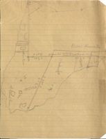
Publi Reversation
N.37°E.
perform him
oilvville
fills & wood hands
321/2
60
R
S
is
20%
less
response
ABSTRACT 0 F TITLE
OF LAND IN
SOUTHWEST HARBOR,
HANCOCK COUNTY, MA INE.
DESCRIBED IN DEED FROM
WILLIAM DRAPER LEWIS
to
HANC OCK COUNTY TRUSTEES
of
PUBLIC RESERVATIONS
RECORDED IN HANCOCK COUNTY
REGISTRY OF DEEDS, IN
BOOK 540, PAGE 241.
EARLY HISTORY
The early history of the title to Mount Desert Island
is set forth on pages 2, 3 and 4 of the Supplement to
"Abstract of Title of land of Hancock County Trustees of
Public Reservations", Vol. 2, and shows that part of the
Island west of Somes Sound to be in John Barnard.
Vol. 372, Page 224.
Mortgage Deed.
Dower not released.
Dated July 6, 1786.
Recorded Feb. 12, 1902.
Sir John Barnard
-to- Thomas Russell
Recorded Lincoln Co. Lib. 19, Folio 88, Sept. 15, 1786.
Copy certified by James H. Varney Reg. recorded in
Hancock Co. Feb. 12, 1902.
DESCRIPTION:
One undivided moiety or half part of the Island of
Mount Desert in said county of Lincoln, which moiety was
granted to me the said John by the Legislature of the
Commonwealth of Massachusetts under the reservations and
exceptions in said grant.
Conditioned to pay 1480 pounds 1 shilling and 4 pence
sterling according to the tenor and condition of a bond
given jointly and severally by me and William Gate, dated
March 31, last past.
And the sum of 579 pounds 9 shillings & 9 pence sterl-
ing according to the tenor of the condition my bond to said
Thomas dated March 31, last past.
And the sum of 50 pounds sterling according to the
tenor of the condition of my other bond to said Thomas
bearing even date with these presents.
Vol. 13, Page 457.
Quitcla im deed.
Dower not released.
Dated Sept. 28, 1803.
Recorded Sept. 15, 1804.
Thomas Russell, by
John L. Sullivan, Adm'r
de bonis non
-to- George Erving.
Recites: "by virtue of a Resolve of the General
Court passed the twenty-sixth day of February last."
DESCRIPTION:
One undivided Moiety of the Island of Mount Desert
in the County of Hancock, which was granted to Sir John
Barnard by Resolve bearing date the fourteenth day of
June one thousand seven hundred and eighty five.
Together with other land.
Recorded in Boston, with Suffolk deed, Lib. 207,
Folio 1, Oct. 10, 1803. On margin appears that it was
also recorded in Essex County Oct. 21, 1803, Book 172
Leaf 269.
Note: No record appears in this county of any fore-
closure of Russell's mortgage nor of the
appointment of Sullivan as Administrator d.b.n.
Vol. 452, Page 134.
Quit-claim Deed.
Dated March 12, 1810.
Recorded Aug. 4, 1908.
George William Erving
by Thomas L.Winthrop,
to
Andrew Tarr.
his attorney.
In Mount Desert.
Whereas the General Court of the Commonwealth of Mass=
achusetts, did, on the 23d day of June, 1875, grant to Sir
John Barnard one undivided moiety or half part of the Island
of Mount Desert, lying in the county of Hancock; and whereas
by several Resolves of the said General Court, passed the
24th day of June, 1806, the 24th day of February, 1807,and
the 12th day of March, 1808, for the relief of the settlers
on that part of Mount Desert Island which was set off to
the said Sir JOHN BARNARD, by partition made by certain
Commissioners appointed by the Supreme Judicial Court of
said Commonwealth, which partition was accepted by said
Court in February 1794 - And whereas among other things it
is provided by the said resolves, that the Agents for the
sale of Eastern lands should be, and they thereby were
authorized to ascertain the persons who, on the 23d day
of June, 1785 were in possession of any of the lands on
Sir John Barnard's moiety of said Island, and whereas the
said Agents did,on the 16th day of August 1808,in pursuance
of the Resolves aforesaid, by special warrant under their
hands,appoint CHARLES TURNER, STEPHEN BADLAM, and SALEM TOWNE,
junior, Esquires, at the expense of the settlers, to survey
and lay out to each settler one hundred acres of land,
and to value the several lots according to their relative
situation with each other, as they were in a state of
nature. And Whereas the said Commissioners, in pursuance
of their instructions, having fully heard the several
persons claiming lands on that part of the Island of Mount
Desert, assigned to Sir John Barnard, did determine and
award that sundry persons named in their report, dated
the 22d day of December, 1808, were entitled to receive
Deeds of one hundred acres of land each, and which the
said Commissioners caused to be surveyed and laid out as
per plan accompanying their said report, which plan and
report are deposited in the office of the said Agent for
the sale of Eastern lands, upon their paying the sums
annexed to their names.
And Whereas the said Commissioners did determine and
award that Andrew Tarr should pay the sum of Seventy
dollars for one hundred acres of land as be their aforesaid
Report and Plan reference thereunto being had will fully
appear.
NOW THEREFORE, I GEORGE WILLIAM ERVING, of Boston, in
the County of Suffolk, and Commonwealth of Massachusetts,
aforesaid, Esquire, in consideration of the aforementioned
sums of Seventy dollars and # cents, do hereby grant, alien
and convey unto the said Andrew Tarr his heirs and assigns
all my right, title, interest and claim in and to the above
described premises.
To have and to hold the same to him the
said Andrew Tarr his heirs and assigns, to his and their use
forever.
NOTE:- Our records do not show the Power of Attorney
to Thomas L. Winthrop.
Vol. 40, Page 489.
Warranty deed.
Dower not released.
Dated June 6, 1814.
Recorded Oct. 13, 1821.
Andrew Tarr
-to-
Comfort Fernald
(Wife of Tobias Fernal d)
A certain tract or parcel of land laying in Mount
Desert aforesaid butted and bounded as follows, viz.
beginning at the shore the corner bound between the said
lot and Tobias Fernald's lot the said Fernald's lot on the
southwest, mountain on the north and river on the east
containing one hundred acres.
Note: From the record it appears that this deed
was not sealed.
Vol. 53, Page 319.
Warranty Deed.
Dower released.
Dated May 29, 1829.
Recorded June 4, 1829.
Comfort Fernald and
Tobias Fernald
-to-
Eben E. Fernald
A certain tract or parcel of land lying in Mount
Desert Aforesaid butted and bounded as follows, viz:
beginning at the shore the corner bound between the said
lot and Leonard Holmes' lot the said Holmes' lot on the
South.and West Mountain on the on the North and river on
the East containing one hundred acres.
Vol. 106, Page 280.
Warranty Deed.
Dower released.
Dated April 17, 1858.
Recorded April 19, 1858.
Eben Fernald
-to- Elijah H. Wasgatt
Three lots in Tremont:-
The first Lot,
Beginning at the head of Dennings Pond containing
one hundred and thirty acres, more or less, and is No.
105 on a plan taken by Salem Town, Jr. Esqr. in 1808.
The Second Lot.
Commencing at the wash house bridge running North
twenty-eight degrees west one hundred and forty-five rods
to John Carrolls south line, then Easterly 18 rods on said
line to the Mountain, thence by the Mountain to the Fern-
ald.Road so called, thence South 45 degrees West to the
first mentioned bound 22 Rods, being sixteen acres more
or less.
The Third Lot.
Also another tract or parcel being the farm that the
said Fernald resides, and butted and bounded as follows,
Beginning at the South East corner of the last lot men-
tioned bounded on the South and West by the Mountain, on the
North and East by Somes Sound containing one hundred acres
more or less together with the buildings thereon.
Note: Third lot is the lot under discussion.
Vol. 107, Page 168.
Warranty Deed. Dower released.
Dated May 6, 1858.
Recorded July 13, 1858.
Elijah H. Wasgatt
to
Oliver H. Fernald.
In Tremont.
The following tracts or parcels of land situated in
the town of Tremont butted and bounded as follows, viz.
Beginning at or near the head of Demmings Pond containing
one hundred and thirty acres more or less and is No. 105
on a plan taken by Salem Town Jr. Esq. in 1808, also
another tract or parcel bounded as follows viz. ---
commencing at the Wash Bridge running North Twenty-eight
degrees West 145 rods to John Carrolls South line, thence
Easterly 18 rods on said line thence by the Mountain to
the Fernald road so called, then South forty-five
degrees West to the first mentioned bound 22 rods being
16 3/4 acres more or less, also another tract butted and
bounded as follows viz. beginning at the South corner
bound between the said lot and the lot last mentioned
butted on the South and West by the Mountain on the
North and East by Somes Sound, containing one hundred
acres to gether with the buildings thereon.
Vol. 111, Page 24.
Warranty Deed.
Dower released.
Dated Jan. 28, 1860.
Recorded Feb. 1, 1860.
Oliver H. Fernald
to
Charles H. Fernald.
In Tremont.
The following tracts or parcels of land situated
in the town of Tremont butted and bounded as follows, viz.
beginning -- the head of Deming's pond containing
one hundred and thirty acres more or less and is No. 105
on a plan taken by Salem Town Jr. Esquire in A. D. 1808.
Also another tract or parcel of land bounded as follows,
commencing at the wash house brook bridge running North
twenty-eight degrees West 145 rods to John Carrolls
South line, then Easterly 18 rods on said line to the
Mountain, thence by the Mountain to the Fernald Road so
called, thence South 45 degrees West to the first
mentioned bound 22 rods being sixteen acres more or less,
Also another tract or parcel of land being the farm that
Eben Fernald occupies bounded as follows, beginning at
the South East corner of the last mentioned lot bounded
on the South and West by the Mountain on the North and
East by Somes Sound, containing one hundred acres more
or less together with the buildings thereon.
Vol. 116, Page 199.
Warranty Deed. Dower not released.
Dated Aug. 20, 1862.
Recorded Sept. 11, 1862.
Charles H. Fernald
to
Sophronia Fernald,
his mother.
In Tremont and Mount Desert.
One equal and undivided half part of the following
tracts out parcels of land situated in the Town of Tremont
and partly in the Town of Mount Desert together with
equal one half part of the undivided buildings thereon
butted and bounded as follows, viz. Beginning at the
head of Demmings Pond a lot containing one hundred and
thirty acres more or less and is No. 105 on a plan
taken by Salem Town's Jr. Esqr. in A. D. 1808. Also
another tract or parcel of land bounded as follows,
commencing at the Deshouse brook bridge running north
twenty-eight degrees West 145 rods to John Carrolls South
line thence Easterly 18 rods on said line to the Mountain
thence by the Mountain to the Fernald road so called
thence South 45 degrees West to the first mentioned bound
22 rods being sixteen acres more or less. Also another lot
or parcel of land being the farm that the said Eben Fernald
now occupies butted and bounded on the South by the harbor
and West by the Somes Mountain on the North and East by
Somes Sound containing one hundred acres more or less.
Vol. 116, Page 200.
Warranty Deed.
Dower not released.
Dated Aug. 20, 1862.
Recorded Sept. 11, 1862.
Charles H. Fernald
to
Capt. Daniel Fernald,
his uncle.
In Tremont and Mount Desert.
One equal and undivided half part of the following
tracts of land situated in the Town of Tremont and partly
in the Town of Mt. Desert together with equal one half
part of the undivided buildings thereon butted and
bounded as as follows, viz beginning at the head of
Demmings Pond a lot containing one hundred and thirty
acres more or less and is No. 105 on a plan taken by
Salem Town Jr. Esqr. in A. D. 1808. Also another tract
or parcel of land bounded as follows commencing at the
Washhouse brook bridge running North twenty-eight degrees
West 145 rods to John Carrolles line thence Easterly 18
rods on said line to the mountain thence by the mountain
to the Fernald road so called thence South 45 degrees East
to the first mentioned bound 22 rods being sixteen acres
more or less. Also another lot or parcel of land being the
farm that the said Eben Fernald now occupies bounded on
the South by the harbor and West by the Somes Mountain
the North and East by Somes Sound containing one hundred
acres more or less.
Vol. 151, Page 239.
Warranty Deed. Dower released.
Dated Aug. 18, 1875.
Recorded Aug. 19, 1875.
Sophronia Fernald
to
Charles H. Fernald.
In Tremont and Mount Desert.
One equal and undivided half part of the following lots
or parcels of land situated in the Town of Tremont and
partly in the town of Mt. Desert together with one half
of the undivided buildings thereon butted and bounded as
follows viz: Beginning at the head of Demings Pond a
lot containing one hundred and thirty acres more or less
and is No 105 on a plan taken by Salem Town Jr. Esq. in
A. D. 1808 also another lot or parcel of land bounded as
follows: commencing at the Wash-house Brook bridge
running north twenty-eight degrees West 145 rods to John
Carrolls South line; thence Easterly eighteen rods on
said line to the mountain thence by the mountain to the
Fernald road so called; thence South 45°rees West to
the first mentioned bound 22 rods being 16 acres more or
less. Also another lot or parcel of land being the farm
now occupied by Eben Fernald butted and bounded on the
South by the harbor on the West by Somes Mountain on the
North and East by Somes Sound containing one hundred
acres more or less.
Note:- A recitation in this deed shows the consideration to be
partly for the life maintenance of the grantor and her husband
Eben Fernald.
Vol. 158, Page 262.
Warranty Deed. Dower not released.
Dated July 17, 1877.
Recorded July 18, 1877.
Daniel Fernald
to
Oliver H. Fernald,
his nephew.
In Tremont and Mount Desert.
Equal halves of three undivided lots or parcels of land
situated partly in the town of Tremont aforesaid, and partly in
the adjoining town of Mt. Desert together with an equal one half
of all the undivided buildings thereon. Said lots being
described as follows to wit:- One Lot at or near the head of
Dunnings pond (or echo lake) Containing one hundred and thirty
acres more or less and is lot numbered One Hundred five (105)
on a plan by Salem Town Jr Esq. in the year eighteen hundred
and eight. (1808) Another lot beginning at the wash-house
brook bridge, thence running North twenty eight degrees West
one hundred fortyfive (145) rods to lot formerly owned by
John Carroll, thence Easterly eighteen (18) rods on said Carrolls
line to the Mountain, thence by the Mountain to the Fernald
road, so called, thence South forty five (45) degrees West to
the first mentioned bound being twenty two (22) rods and
containing sixteen (16) acres more or less. Also another lot
known as the "Fernald Farm" situated in said Tremont, occupied
and managed by Eben and Daniel Fernald, brothers, and is bounded
as follows to wit:- On the South by the Harbor, On the West
by the Somes Mountain. On the North and East by Somes Sound,
and contains one hundred (100) acres more or less.
Note: Deed shows that part consideration was life support of
Grantor.
Vol. 158, Page 262.
Bond.
Dated July 17, 1877.
Recorded July 18, 1877.
Oliver H. Fernald
to
Daniel H. Fernald.
Bond in the sum of $5000. The condition of the above
Obligation is such that if the said Oliver H. Fernald shall
during the natural life of the above named Daniel Fernald
suitably support and maintain the said Daniel Fernald and
provide him with suitable clothes, food, drink, medicine and
nursing and all other things necessary in the house of the
said Oliver H. Fernald on the "Fernald Farm" so called, in
said town of Tremont, then this Obligation shall be void,
otherwise the same shall remain in full force.
Vol. 163, Page 30.
Quitclaim deed.
Dower released.
Dated July 25, 18787
Recorded July 27, 1878.
Charles H. Fernald
-to-
Oliver H. Fernald
All my right, title and interest in and to a certain
lot or parcel of land situated in district No. 1 in the
Town of Tremont, County of Hancock, State of Maine, being
a portion of the Fernald farm, so called, and described as
follows, to wit:- Beginning at a stake on the shore about
one and one half rods East of the Eastern end of the pond
thence North twenty-nine degrees west sixty and one half
rods, more or less, to a cedar stake on the North side
of the field, thence North thirty-seven degrees East
sixty-four rods to the shore of Somes Sound, thence
following said shore Southerly and Westerly to the first
mentioned bound, containing fourteen acres more or less,
together with the rightof way as follows, viz:- Beginning
at the Town road four rods north of the western end of the
barn and running about east North east across land owned
by the above named Grantor to land owned by the above
named Grantee.
Vol. 397, Page 316.
Abstract of Will.
Dated Sept. 2, 1903.
Recorded Sept. 21, 1903.
Oliver H. Fernald
-to-
Ruth A. Fernald and
Louise L. Fernald.
First: I give, bequeath and devise to my wife
Ruth A. Fernald and my daughter Louisa L. Fernald all my
real and personal estate whe rever found and howeversit-
uated to be held by them jointly and in fee and at the
death of either the remaining property not disposed of
shall go to the survivor, and in the event of the death
of either before mine I give said property to the one then
living in fee.
Note: Oliver Fernald died
His will was allowed by the Probate Court
September 1, 1903, and Ruth A. Fernald and
Louisa L. Fernald were appointed executors.
Vol. 452, Page 136.
Warranty Deed.
Dower released.
Dated April 9,1908.
Recorded August 4, 1908.
Charles H. Fernald
to
Henry T. Fernald.
In Southwest Harbor (formerly Tremont).
A certain tract or parcel of land situated in District
No. 1, in the town of Southwest Harbor (formerly Tremont),
County of Hancock, State of Maine, being a portion of the
"Fernald Farm" so called and described as follows, to wit:
Beginning at a. stake on the south side of the road in
the western end of the field, near the bridge; thence
following said road southeasterly fifty five and one half
rods to a stake on the west side of said road; thence north
thirty seven degrees east crossing the road thirty two and
one fourth rods to a stake; thence south twenty n'ine de-
grees east sixty and one half rods more or less to a stake
at the shore about one and one half rods east of the eastern
end of the pond; thence following the shore westerly to the first
mentioned bound. Containing fifteen acres of land be the
same more or less, and being the same premises conveyed to
me by quit-claim deed of Oliver H. Fernald, dated the twenty
fifth day of July, A.D. 1878 and recorded in Hancock Registry
of Deeds, in Book 163, Page 29.
Excepting and reserving however, so much of said premises
as I have conveyed to Oliver H. Fernald by warranty deed,
dated the twenty sixth day of July, A.D. 1878 and recorded
in Hancock Registry of Deeds Book 162, Page 388, to Oliver
H. Fernald and his wife R. Amelia Fernald by warranty deed
dated the seventh day of August, A.D. 1882, and recorded
in Hancock Registry of Deeds, Book 181, Page 329, to Oliver
H. and Ruth A. Fernald by quit-claim deed, dated the first
day of October A.D. 1890 and recorded in Hancock Registry
of Deeds, Book 244, Page 371, and to Oliver H. and Ruth A.
Fernald by quit-claim deed, dated the first day of October,
A.D. 1890, and recorded in Hancock Registry of Deeds, Book
244, Page 372.
Also one undivided half of one other tract or parcel
of land, situated in said Southwest Harbor, and described
as follows, to wit:
Beginning at a stake on the south side of the road in
the western end of the field on what is known as the
"Fernald Farm" near the bridge; thence following said road
south easterly about fifty five and one half rods to a
stake on the west side of said road; thence north thirty
seven degrees east crossing said road, about thirty two and
one fourth rods to a stake; thence north thirty seven degrees
east about seventy one rods to a stake at the shore; thence
northwesterly along said shore to a bolt in the rock at or
near the town line; thence south easterly about thirty nine
rods to a bolt in the rock; thence southerly about one
hundred and fifty rods to a bolt in the rock; thence south
easterly about thirty rods to the shore; thence northeast-
erly along said shore to the place of beginning. Contain-
ing one hundred and eighteen acres and thirty seven square
rods of land, be the same more or less and being that un-
divided portion of the third parcel of land conveyed to me
by warranty deed of Sophronia Fernald, dated the eighteenth
day of August, A.D. 1875 and recorded in Hancock Registry of
Deeds, Book 151, Page 239.
Also one undivided half of one other tract or parcel
of land situated in said South West Harbor, bescribed as
follows, to wit:
Beginning at the Wash-house Brook bridge so called,
thence running north twenty eight degrees west about one
hundred and forty five rods to John Carroll's south line,
thence easterly about eighteen rods on said Carroll's line
to the mountain, thence by the mountain to the "Fernald
Road" so called, thence south forty five degrees west about
twenty two rods to the first mentioned bound. Containing
sixteen acres, more or less.
Also one undivided half of one other tract or parcel
of land situated partly in the said town of South West
Harbor and partly in the town of Mount Desert, and described
as follows, to wit:-
Beginning at the head of Denning's Pond, a lot containing
one hundred and thirty acres more or less, and is No.105 on
a plan taken by Salem Towns Jr.Esq. in A.D. 1808.
NOTE: The acknowledgment in this deed is defective to
cure it a new deed was given, see following page. Recorded
in Vol. 533, Page 194.
Vol. 533, Page 194.
Warranty Deed.
Dower released.
Dated Jan. 20, 1917.
Recorded Jan. 24, 1917.
Charles H. Fernald
-to-
Henry T. Fernald
This is a conveyance of the same premises set forth
on the preceeding page, given to cure the defect in the
acknowledgment of that deed.
Vol, 534, Page 404.
Release Deed.
Dower released.
Dated Oct. 22, 1917.
Recorded Nov. 19, 1917.
Charles H. Fernald
to
Ruth A. Fernald and
Louise L. Fernald.
In Southwest Harbor.
All my right, title and interest in and to the several tracts
or parcels of land comprising the shore frontage or land
between high water mark and low water mark in front of and
adjoining the several tracts or parcels of land now owned by
the said Ruth A. Fernald and Louise L. Fernald, situated in
what was formerly known as District No. 1, in the town of Tremont
now Southwest Harbor, in said County of Hancock, State of Maine,
and being a portion of the Fernald Farm, so called, for a more
particular description of said lands reference is hereby made
to the following conveyances:
1. Deed from Charles H. Fernald to Oliver H. Fernald, dated
July 25 A. D. 1878 and recorded in the Hancock County, Maine,
Registry of Deeds, Volume 163, Page 30.
2. Deed from Charles H. Fernald to Oliver H. Fernald, dated
July 26 A. D. 1878, recorded in said registry, Volume 162,
Page 388.
3. Deed from Charles H. Fernald to Oliver H. Fernald and his
wife R. Amelia Fernald, dated August 7, A. D. 1882, recorded
in said registry Volume 181, Page 329.
4. Deed from Charles H. Fernald to Oliver H. Fernald and Ruth
A. Fernald, dated October 1, A. D. 1890, recorded in said
registry, Volume 244, Page 371.
5. Deed from Charles H. Fernald to Oliver H. Fernald and
Ruth A. Fernald, dated October 1, A. D. 1890, recorded in said
registry, in Volume 244, Page 372.
Vol. 537, Page 77.
Indenture.
Dower released.
Dated July 16, 1917.
Recorded July 28, 1917.
Between
Ruth A. Fernald and
Henry T. Fernald of the
and
Louise L. Fernald
first part,
parties of the second part.
In Southwest Harbor.
Witnesseth; Whereas, on the 25th day of July A. D. 1878,
Charles H. Fernald, then of Orono, Maine, and Oliver H. Fernald
then of Newport, Rhode Island, being owners in common and
undivided of a certain tract or parcel of land situate in the
then town of Tremont, now Southwest Harbor, in said County of
Hancock, State of Maine, known as Fernald's farm, for the
purpose of making a division of that portion of said farm
known as "the Field", by their quit-claim deeds of that date,
set out and conveyed each to the other certain specific
parcels of said field, each to hold the parcel so granted to
him in severalty thereafter; said deed from Oliver H. to
Charles H. Fernald being recorded in the Hancock County, Maine,
Registry of Deeds, Volume 163, Page 29, the description
therein of the property released and conveyed being as follows;
All my right title and interest in and to a certain lot
or parcel of land situated in District No. 1 in the Town of
Tremont County of Hancock State of Maine, being a portion of
the Fernald farm so called and described as follows to wit--
Beginning at a stake on the South side of the road
in the western end of the field near the bridge thence
following said road southeasterly fifty five and one half
rods to a stake on the west side of the road. Thence
North thirty seven degrees east crossing the road thirty
two and one fourth rods to a stake Thence South twenty nine
degrees East sixty and one half rods more or less to a
stake at the shore about one and one half rods east of the
eastern end of the pond- Thence following the shore
westerly to the first mentioned bound containing fifteen
acres more or less;" said deed from Charles H. to Oliver H.
Fernald being recorded in said registry, Volume 163, Page 30,
the description therein of the property released and conveyed
being as follows:
"All my right, title and interest in and to a certain lot
or parcel of land situated in District No. 1 in the Town of
Tremont County of Hancock State of Maine being a portion of
the Fernald farm so called and described as follows to wit--
Beginning at a stake on the shore about one and one half
rods East of the Eastern end of the pond. Thence North
twenty nine degrees west sixty and one half rods more or
less to a cedar stake on the north side of the field- thence
North thirty seven degrees East sixty four rods to the shore
of Somes Sound- Thence following said shore southerly and
westerly to the first mentioned bound containing fourteen
acres more or less together with the right of way as follows
viz. Beginning at the town road four rods north of the
western end of the barn and running about East North east
across land owned by the above named grantor to land owned
by the above named grantee."
And whereas, one of the division lines between the
divided field lots so called, and the undivided pasture or
mountain lot, namely, the line set forth in the deed first
mentioned as running from a stake on the west side of the
road "Thence North thirty seventy degrees East crossing the
road thirty two and one fourth rods to a stake, " and in the
deed last above mentioned as running from a cedar stake on
the north side of the field "Thence North thirty seven degrees
East sixty four rods to the shore of Somes Sound" (the two
lines forming one continuous straight line from said stake
at the road to the Sound), is uncertain and cannot now be
clearly located, the parties hereto (the party of the first
part being the present owner of that portion of said Fernald's
farm formerly of Charles H. Fernald, except four certain
small adjoining lots acquired by said Oliver H. of said
Charles H. Fernald subsequent to said division between them,
and comprising the Oliver H. Fernald home lots so called,
for a more particular description of which reference is
hereinafter made; and the parties of the second part being
the present owners of that portion of said farm formerly of
Oliver H. Fernald) being desirous of fixing and establishing
the particular division line just above mentioned, do hereby
agree each with the other that said line shall be and hereby
is located and established as follows:
Beginning at the center of the town way near the dwelling
house of the parties of the second part forty feet distant
and in a direction South thiety nine degrees and forty five
minutes West from an iron bolt set in a large boulder; thence
running North thirty nine degrees and forty five minutes
East forty feet to said iron bolt set in said boulder;
thence on same course two hundred fourteen and five tenths
(214.5) feet to a stone post; thence on same course two
hundred sixty five and six tenths (265.6) feet to a stone
post; thence on same course one hundred thirty seven and
four tenths (137.4) feet to a stone post; thence on the same
course six hundred and sixty five (665) feet to a stone
post; thence on the same course one hundred eighty three
[183) feet to a bolt; thence on the same course one hundred
ninety three and seven tenths (193.7) feet to a stake at
high water mark at the shore of Somes Sound; thence on the
same course forty (40) feet to a bolt in a large flat topped
boulder about twelve feet below high water mark; then
returning to the point of beginning at the center of the
road and running south thirty nine degrees and forty five
minutes West to the west side of said road.
The foregoing description is from a plan of said division
line made by Alvah L. Reed, Surveyor, to be recorded in the
Hancock County, Maine, Registry of Deeds, Book of Plans.
And the party of the first part in consideration of the
premises and of further other valuable considerations paid
by the parties of the second part, the receipt whereof is
hereby acknowledged, does hereby remise, release, and forever
quit-claim unto the parties of the second part, their heirsns
and assigns, all his right, title and interest in and to
all that parcel or tract of land bounded generally as follows;
Westerly by the old division line which begins at a stake
near the pond and runs North twenty nine degrees West produced,
if necessary, until it meets the division line herein
established, which point is marked by a stone post; north-
westerly by the northerly part of the division line herein
established; easterly and southerly by the shore of Somes
Sound.
And the parties of the second part in consideration
of the premises and of further other valuable considerations
paid by the party of the first part, the receipt whereof is
hereby acknowledged, do hereby remise, release, and forever
quit-claim unto the party of the first part all that parcel or
tract of land bounded generally as follows:
Northerly by the old division line which begins at a
stake on the south side of the road near the bridge and
follows said road fifty five and one half rods to a stake
on the west side of the road; northwesterly by the southerly
part of the herein established division line; easterly by
the old division line which begins at a stake near the pond
and runs North 29 degrees West, produced, if necessary,
until it meets the division line herein established, southerly
by the shore; excepting however, and not including in this
release, four certain small tracts or parcels of land
comprising the home lots of the parties of the second part,
reference being had for a more particular description of
the same to the conveyances following: (1) Deed from Charles
H. Fernald to Oliver H. Fernald, dated July 26, 1878,
recorded in the Hancock County, Maine, Registry of deeds,
Volume 162, Page 388; (2) Deed from Charles H. Fernald to
Oliver H. Fernald and his wife, R. Amelia Fernald, dated
August 7, 1882, and recorded in said registry, Volume 181,
Page 329; (3) Deed from Charles H. Fernald to Oliver H. and
Ruth A. Fernald, dated October 1, 1890, recorded in said
registry, Volume 244, Page 371; (4) Deed from Charles H.
Fernald to Oliver H. and Ruth A. Fernald, dated October 1,
1890, recorded in said registry, Volume 244, Page 372;
excepting also and not including in this release any right
or interest which the parties of the second part may have in
the right of way described in the original division deed
from Charles H. to Oliver H. Fernald, recorded in said
registry, Volume 163, Page 30.
Vol. 537, Page 81.
Release Deed.
Dower released.
Dated July 16, 1917.
Recorded July 28, 1917.
Henry T. Fernald
to
Ruth A. Fernald and
Louise L. Fernald.
In Southwest Harbor.
All my right, title and interest in and to the several tracts
or parcels of land comprising the shore frontageor land between
high and low water mark in front of the several tracts of land
now owned by the said Ruth A. Fernald and Louise L. Fernald in
District No. 1, (formerly) in the town of Tremont (formerly),
now Southwest Harbor, in said county of Hancock, being a portion
of the Fernald farm, so called; for a more particular description
of said lands reference is hereby made to the following
conveyances.
Deed from Charles H. Fernald to Oliver H. Fernald, dated
July 25, 1878, recorded in Hancock County, Maine, Registry of
Deeds, Volume 163, Page 30; deed from Charles H. Fernald to
Oliver H. Fernald, dated July 26, 1878, recorded in said
registry, Volume 162, Page 388; deed from Charles H. Fernald
to Oliver H. Fernald and his wife, R. Amelia Fernald, dated
August 7, 1882, recorded in said registry, Volume 181, Page 329;
deed from Charles H. Fernald to Oliver H. Fermald and Ruth A.
Fernald, dated October 1, 1890, recorded in said registry,
Volume 244, Page 371; deed from Charles H. Fernald to Oliver H.
Fernald and Ruth A. Fernald, dated October 1, 1890, recorded in
said registry, Volume 244, Page 372.
Vol. 538, Page 7.
Warranty Deed.
Dower released.
Dated Aug. 16, 1917.
Recorded Aug. 23, 1917.
Ruth A. Fernald
William Draper Lewis
Louise L. Fernald and
-to-
and Charlton Yarnell
Henry T. Fernald
and the survivor.
A certain lot or parcel of land situated in the Town
of Southwest Harbor in said County of Hancock, State of
Maine, including Flying Mountain, so-called, and bounded
and described as follows, to wit:-
Beginning at a point at or near the northerly side of
the Town road leading from Norwood's Cove to Fernalds Point,
s-called, about three hundred and seven feet easterly of
the center of the brook at the north side of the bridge
over said brook at the head of Fernalds Cove, said point
at this date bears south twenty-six degrees thirty minutes
west and is twenty-seven feet distant from a stone bound
set in the ground on the northerly side of said road and
about twenty feet easterly of an old wood road; thence from
said point westerly following the northerly side of said
road three hundred and seven feet, more or less, to a point
in the center of the said brook at the north side of said
bridge: said last named point in the center of said brook
bears south'sixty degrees thirty minutes west and is forty-
nine feet distant from a bolt set in a small boulder that
is three feet northerly of the eastend of the bridge wall
and at about high water; thence generally northerly follow-
ing the center of said brook about four hundred and fifty
feet to 8 point that bears south sixty-three degrees thirty
538-7
2-
minutes east and is six feet distant from 8. stone bound set
in the ground on the westerly bank of said brook; thence
north sixty-three degrees thirty minutes west six feet to
said last mentioned stone: thence continuing in same course
two hundred and forty- - five and seven tenths feet to a bolt
set in 8 small bluff ledge in the Dog Mountain lot line;
thence generally northerly following the easterly line of
the Dog Mountain lot through a bolt near the shore to low
water of Somes Sound at Valley Cove, so-called: thence gen-
erally easterly and southerly following low water of said
Somes Sound to a point about six hundred feet northerly
(measuring along the shore) from the northerly edge of the
Fernald Farm field, so-called, said point bears north
thirty-nine degrees forty-five minutes east from a stone
set in the ground on the top of the bank about sixty feet
above high water; thence from said point south thirty-nine
degrees forty-five minutes west to said stone on the top
of the bank; thence in same course fourteen hundred and
eighty-three and six tenths feet to a bolt set in a small
boulder; thence north sixty-three degrees thirty minutes
west six hundred and forty-three and five tenths feet to a
bolt set in the ledge: thence south twenty-six degrees
thirty minutes west three hundred and seventy-four and eight
tenths feet to the stone first mentioned; thence in same
course twenty-seven feet to the point of beginning, containing
one hundred acres, more or less.
Vol. 540, Page 241. Quitclaim deed. Dower released.
Dated November 27, 1917.
Recorded May 7, 1918.
William Draper Lewis and
Hancock County Trustees
Charlton Yarnall
-to-
of Public Reservations.
A certain lot or parcel of land situated in the Town
of Southwest Harbor in said County of Hancock, State of
Maine, including Flying Mountain, so-called, and bounded
and described as follows, to wit:-
Beginning at a point at or near the northerly side of
the town road leading from Norwood's Cove to Fernalds
Point, so-called, about three hundred and seven feet easter-
ly of the center of the brook at the north side of the
bridge'over said brook at the head of Fernalds Cove, said
point at this date bears south twenty-six degrees, thirty
minutes west and is twenty-seven feet distant from a
stone bound set in the ground on the northerly side of said
road and about twenty feet easterly of anold wood road;
thence from said point westerly following the northerly
side of said road three hundred and seven feet, more or
less, to a point in the center of the said brook at the
north side of said bridge; said last named point in the
center of said brook bears south sixty degrees thirty min-
utes west and is forty-nine feet distant from a bolt set
in a small boulder that is three feet northerly of the
eastern end of the bridge wall and at about high water;
thence generally northerly following the center of said
brook about four hundred and fifty feet to a point that
540-241
2-
bears south sixty-three degrees thirty minutes east and is
six feet distant from a stone bound set in the ground on
the westerly bank of said brook; thence north sixty-three
degrees thirty minutes west six feet to said last mention-
ed stone; thence continuing in same course two hundred and
forty-five and seven tenths feet to a bolt set in a small
bluff ledge in the Dog Mountain lot line: thence generally
northerly following the easterly line of the Dog Mountain
lot through a bolt near the shore to low water of Somes
Sound at Valley Cove, so-called; thence generally easterly
and southerly following low water of said Somes Sound to
a point about six hundred feet northerly (measuring along
the shore) from the northerly edge of the Fernald Farm
field, so-called, said point bears north thirty-nine degrees
forty-five minutes east from a stone set in the ground on
the top of the bank about sixty feet above high water:
thence from said point south thirty-nine degrees forty-
five minutes west to said stone on the top of the bank:
thence in same course fourteen hundred and eighty-three
and six tenths feet to abolt set in a small boulder; thence
north sixty-three degrees thirty minutes west six hundred
and forty-three and five tenths feet to a bolt set in the
ledge; thence south twenty-six degrees thirty minutes west
three hundred and seventy-four and eight tenths feet to the
stone first mentioned; thence in same course twenty-saven
feet to the point of beginning, containing one hundred
acres, more or less.
3-
Meaning and intending to include and hereby convey
the same premises, described as conveyed in a certain
deed from Ruth A. Fernald, Louise L. Fernald and Henry
T. Fernald, dated August sixteenth, 1917 and recorded in
the Hancock County Maine Registry of Deeds, Book 538, Page
7.
Vol. 58, Page 161.
Executors deed.
Dated August 29, 1831.
Recorded July 2, 1833.
John Q. Adams,
Nathaniel Curtis,
and Alicia Boylston,
Executors & Trustees of
Ward N. Boylston
-to-
Daniel Fernald
A certain lot of land lying in said Mt. Desert
containing one hundred and thirty acres more or less
& is No. 105 on a plan taken by Salem Towne Jr.,
Esquire in 1808.
Vol. 65, Page 13.
Warranty Deed.
Dower not released.
Dated May 22, 1835.
Recorded June 2 1, 1837.
Daniel Fernald
to
Eben Fernald.
In Mount Desert.
A certain tract or parcel of land laying in Mount Desert
aforesaid containing One hundred & thirty acres more or less
& is No 105 on a plan taken by Salem Town Jun. Esq. in 1808.
Vol. 457, Page 307. Quitclaim Deed. Dower released.
Dated December 5, 1908.
Recorded February 2, 1909.
Henry T. Fernald, Ruth A.
Fernald and Louise L. Fernald -to- John H. Macomber
That certain tract or parcel of land, containing one
hundred and thirty (130) acres, more or less, which is No.
105 on a plan taken by Salem Towne Jr. in 1808, which plan,
or a copy thereof, is now in the office of the Register of
Deeds of Hancock County, Maine, It being the same lot which
was conveyed to Daniel Fernald by John 2. Adams, Nathaniel
Curtis and - - Boylston, Executors and Trustees of the
last will and testament of David N. Boylston, by warranty
deed dated the twenty ninth day of August A.D. 1831 and re-
corded in Hancock Co. Registry of Deeds July 2, 1833, in
Book 58, Page 161.
Said tract of land is situated partly in the town of
Southwest Harbor and partly in the town of Mount Desert,
Maine.
Vol. 457, Page 309.
Mortgage Deed.
Dower released.
Dated January 19, 1909.
Recorded February 2, 1909.
John H. Macomber
-to-
R.H. Bridgham Fernald.
This is a mortgage of one-half of lot No. 105, given
to secure the sum of $375., and was discharged by instru-
ment dated January 21, 1910, and recorded in Book 466,
Page 287.
Vol. 457, Page 312. Quitclaim deed. Dower released.
Dated January 19, 1909.
Recorded February 2, 1909.
John H. Macomber
-to- R. H. Bridgham Fernald
One undivided half part of that certain tract or parcel
of land containing one hundred and thirty acres, more or less,
which is No. 105 on a plan taken by Salem Towne Jr. in 1808,
which plan, or a copy thereof, is now in the office of the
Registry of Deeds of Hancock County, Maine. It being the
lot which was conveyed to Daniel Fernald by John Q. Adams,
Nathaniel Curtis, and ---- Boylston, Executors and Trustees
of the last will and testament of David N. Boylston, by
warranty deed dated the twenty ninth day of August A.D.
1831, and recorded in Hancock County Registry of Deeds July
2, 1833, in Book 58, Page 161.
Said tract of land is situated partly in the town of
Southwest Harbor and partly in the town of Mount Desert,
Maine.
Meaning hereby to convey one undivided half part of
that certain tract or parcel of land described as conveyed
to me by Henry T. Fernald, Ruth A. Fernald, and Louise L.
Fernald by their quitclaim deed dated December 5, A.D.
1908, to be recorded in the Hancock County, Maine, Registry
of Deeds.
Vol. 457, Page 314.
Agreement
Dated January 19, 1909.
Recorded February 2, 1909.
This is an agreement between John H. Macomber and
R. H. Bridgham Fernald that no wo od shall be cut upon
Lot No. 105 without the consent of both parties.
All proceeds from sale of stumpage to be paid to said
Fernald who is to retain one-half for his own and credit
the other half on the mortgage note of said Macomber, and
they also make an agreement regarding the establishing of
lines etc., in case they desire to divide the property
within one year.
Vol. 466, Page 288. Quitclaim deed. Dower released.
Dated January 19, 1910.
Recorded January 22, 1910;
John H. Macomber
-to- R. H. Bridgham Fernald
One undivided half part of that certain tract or parcel
of land containing one hundred and thirty acres, more or
less, which is No..105 on a plan taken by Salem Town, Jr.
in 1808, which plan, or a copy thereof, is now in the office
of the Registry of Deeds of Hancock Co., Maine, it being the
lot which was conveyed to Daniel Fernald by John Q. Adams,
Nathaniel Curtis, and -- Boylston, Executors and Trustees
of the last will and testament of David N. Boylston, by
warranty deed dated the twenty ninth day of August A.D.1831,
and recorded in Hanco cl County Registry of Deeds, July 2nd,
1833, in Book 58, Page 161. Said tract of land is situated
partly in the Town of South West Harbor, and partly in the
Town of Mt. Desert, Maine. Meaning hereby to convey one
undivided half part, with all my interest in and to the same,
of that certain tract or parcel of land described as conveyed
to me by Henry T. Fernald, Ruth A. Fernald and Louise L.
Fernald, by their quitclaim deed, dated December 5th, A.D.
1908, and recorded in Hancock County Registry of Deeds, Book
457, Page 307. The remaining one undivided half part of
said tract of land I have already conveyed to the said R.H.
Bridgham Fernald by my quitclaim deed dated January 19th,
A.D. 1909, and recorded in Hancock County Registry of Deeds,
February 2nd, 1909, in Book 457, Page 312.
Vol. 533, Page 476. Quitclaim deed. Dower released.
Dated February 21, 1917.
Recorded March 17, 1917.
R. H. Bridgham Fernald
-to- Schuyler R. Clark
All my right, title and interest in and to that certain
tract or parcel of land containing one hundred and thirty
(130) acres more or less which is no. 105 on & plan taken by
Salem Town, Jr. in 1808, which plan or a copy thereof is now
in the office of the Register of Deeds of Hancock County
Maine. It being the same lot which was conveyed to Daniel
Fernald by John Q. Adams, Nathaniel Curtis, and --- Boylston,
Executors and Trustees of the last will and testament of
David N. Boylston, by warranty deed dated the twenty ninth
day of August A.D. 1831, and recorded in Hancock Co. Registry
of Deeds July 2, 1833, in Book 58 Page 161. Said tract of
land is situated partly in the Town of Southwest Harbor, and
partly in the town of Mt. Desert, Maine, Meaning hereby to
convey that certain tract or parcel of land described as con-
veyed to John H. Macomber by Henry T. Fernald, Ruth A. Fern-
ald and Louise L. Fernald, by their quitclaim deed dated
December 5 A.D. 1908, and recorded in the Hancock Co. Maine
Registry of Deeds, Book 457, Page 307, and conveyed to me by
John H. Macomber by his deeds dated January 19, 1909, and
and January 19- 1910, and recorded in Hanco ck Co. Registry
of Deeds, February 2nd 1909, in Book 457, Page 312, and
January 22- 1910, in Book 466, Page 288.
Vol. 533, Page 523. Quitcla im deed. Dower released.
Dated March 17, 1917.
Recorded March 27, 1917.
Schuyler R. Clark
-to- The Wild Gardens of Acadia.
That certain tract or parcel of land, containing one hun-
dred and thirty (130) acres more or less, which is lot No. 105
on a plan taken by Salem Town Jr. in 1808, which plan or a
copy thereof, is now in the Registry of Deeds of Hancock
County, Maine.
It being the same lot which was conveyed to Daniel Fern-
ald by John Q. Adams, Nathaniel Curtis and Alicia Boylston,
Executors and Trustees of the last will and testament of Ward
N. Boylston, by deed dated the twenty-ninth day of August A.
D. 1831, and recorded in Hancock County Maine Registry of
Deeds July 2nd. 1833, in Book 58, Page 161.
partly
Said tract of land is situated/in the town of Southwest
Harbor and partly in the town of Mount Desert in the said
County of Hancock. Reference is hereby given to deed of
Henry T. Fernald, Ruth A. Fernald, and Louise L. Fernald, to
John H. Macomber by deed dated December 5th. A.D. 1908, and
recorded in said Registry of Deeds, Book 457, page 307, also
deeds of John H. Macomber to R. H. Bridgham Fernald, dated
January 19th. 1909, and January 19th. 1910 and recorded in
said Registry of Deeds, Feby. 2nd 1909, in Book 457, Page
312 and January 22nd, 1910, Book 466, Page 288, and being
the same premises conveyed to me by deed dated February 21st,
A.D. 1917, by R. H. Bridgham Fernald, and to be herewith re-
corded.
March 26, 1920.
Dr. J. D. Phillips,
Southwest Harbor, Maine.
My dear Doctor:
I am enclosing herewith abstract of the
deed of the Reservation's ownership on or near Fernald's
Point.
I have talked with Mr. Dorr regrading the golf
proposition.
He thinks none of this land is suitable
for pelf purposes. He wishes, however, to 'discuss the
matter with you at your convenience.
Very truly yours,
L/H
June 12, 1920
Mr. William Draper Lewis
University of Pennsylvania,
Philadelphia, Pa.
Dear Sir:
I beg to acknowledge receipt of
yours of the 7th enclosing Southwest Harbor
tax bills. I will take the matter up with
the proper authorities at once.
L/M
Yours truly,
June 2, 19
Mr. William Draper Lewis,
University of Pennsylvania,
Philadelphia, P8.
Dear Sir:
I beg to. acknowledge receipt of
yours of the 29th in connection with the
tax bill on Flying Mountain. You omitted
to enclose the bill and Mr. Keena's letter.
If you will kindly send them to me, I will
take the matter 72]) at once.
I/M
Yours truly,
UNIVERSITY OF PENNSYLVANIA
PHILADELPHIA
THE LAW SCHOOL
May 29, 1920.
Mr. Lynam,
Attorney at Law,
Bar Harbor, Maine.
Dear Mr. Lynam;-
I enclose letter and Tax Bills
received from W. R. Keene, of Manset; also
a copy of my letter to him.
The correspondence
expalins itself.
Sincerely,
UNIVERSITY OF PENNSYLVANIA
PHILADELPHIA
THE LAW SCHOOL
May 29, 1920.
Mr. W. R. Keene,
Manset.
Maine:
My dear Mr. Econe:-
I have nothing further to do with
any property in South West Harbor, as Mr. Yarnall
and I conveyed Flying Mountain to the trustees of
Public Lands of Hanoock County.
I am, therefore. sending your
letter and bills to Mr. Lynam. at Bar Harbor,
who represents the trustees.
Sincerely,
Vol. 553, page 269
Warranty deed Dower released
Dated August 26, 1920
Recorded September 22, 1920.
Henry T. Fernald
-to-
Emily B.D. Macomber
A certain lot or parcel of land situated on Fernald's Point,
so-called, in the town of Southwest Harbor, County of Hancock, and
State of Maine, bounded and described as follows, to wit:
BEGINNING at a stone bound set in the ground on the bank about
fifteen (15) feet above high water mark and in the west line of land
conveyed by Ruth A. Fernald and Louise L. Fernald to Mary C. Wheel-
wright; thence from said stone bound North twenty seven degrees
West (N. 27° W.) following said western line of land of Mary C.
Wheelwright nine hundred eighty seven (987) feet to a stone bound
set in the ground in the head of the field in the original division
line: thence South thirty nine degrees and forty five minutes West
(S. 39° 45' W. ) following said original division line two hundred
sixty five and six tenths (265.6) feet to a stone bound set in the
ground at the southeast corner of a lot of land of the Grantor known
as Rocky Pasture;thence North twenty five degrees and forty five
minutes West (N. 25° 45' W.) following the east line of said Rocky
Pasture lot, crossing in its course a private road or way leading
easterly from the town road, two hundred sixteen (216) feet, more
or less, to a bolt set in a boulder marking the north east corner
of said Rocky Pasture lot; thence South thirty nine degrees thirty
minutes West (S. 39° 30' W.) following the northerly line of said
Rocky Pasture lot, crossing in its course said private road or way,
Vol. 553, Page 269
Warranty deed Dower released
Dated August 26, 1920
Recorded September 22, 1920.
Henry T. Fernald
-to-
Emily B.D. Macomber
A certain lot or parcel of land situated on Fernald's Point,
so-called, in the town of Southwest Harbor, County of Hancock, and
State of Maine, bounded and described as follows, to wit:
beginning at a stone bound set in the ground on the bank about
fifteen (15) feet above high water mark and in the west line of land
conveyed by Ruth A. Fernald and Louise L. Fernald to Mary C. Wheel-
wright; thence from said stone bound North twenty seven degrees
West (N. 27° W.) following said western line of land of Mary C.
Wheelwright nine hundred eighty seven (987) feet to a stone bound
set in the ground in the head of the field in the original division
line: thence South thirty nine degrees and forty five minutes West
(S. 39° 45' W. following said original division line two hundred
sixty five and six tenths (265.6) feet to a stone bound set in the
ground at the southeast corner of a lot of land of the Grantor known
as Rocky Pasture thence North twenty five degrees and forty five
minutes West (N. 25° 45' W.) following the east line of said Rocky
Pasture lot, crossing in its course a private road or way leading
easterly from the town road, two hundred sixteen (216) feet, more
or less, to a bolt set in a boulder marking the north east corner
of said Rocky Pasture lot; thence South thirty nine degrees thirty
minutes West (S. 39° 30' W. ) following the northerly line of said
Rocky Pasture lot, crossing in its course said private road or way,
553 - 269
-2-
two hundred eighty nine (289) feet, more or less, to a stone bound
marking the northwest corner thereof at or near the east side of
the town road; thence South forty four degrees and thirty minutes
East (S. 44° 30'E.) along said town road three hundred thirty nine
(339) feet to a stone bound set in the ground; thence South thirty
two degrees and twenty minutes East (s. 32° 20' E.) five hundred
eighty three and two tenths (583.2) feet to a stone bound set in
the ground; thence on same course thirty (30) feet to high water
mark; thence easterly following the line of high water mark to a
point that bears South twenty seven degrees East (s. 27° E.) from
the first mentioned bound; thence North twenty seven degrees West
(N. 27° W.) fifteen (15) feet, more or less, to the stone bound at
the place of beginning.
Together with all my right, title and interest in and to the
land lying between said line of high water mark and low water mark.
Containing in the whole approximately nine and 43/100 acres.
ALSO one half part in common and undivided of two other certain
lots or parcels of land situs ted at said Fernald's Point, Southwest
Harbor, Maine, adjoining the lot hereinabove described, and bounded
and described as follows, to wit:
1. Beginning at a stone bound set in the ground at the north-
west corner of a lot of the Grantor known as Rocky Pasture: thence
North thirty nine degrees and thirty minutes East (N. 39° 30' E.)
following the north line of said lot one hundred forty (140) feet,
more or less, to the center of a private road or way leading east-
erly from the town road; thence westerly following the center of
553 - 269
-2-
two hundred eighty nine (289) feet, more or less, to a stone bound
marking the northwest corner thereof at or near the east side of
the town road; thence South forty four degrees and thirty minutes
East (S. 44° 30'E.) along said town road three hundred thirty nine
(339) feet to a stone bound set in the ground; thence South thirty
two degrees and twenty minutes East (S. 32° 20' E.) five hundred
eighty three and two tenths (583.2) feet to a stone bound set in
the ground: thence on same course thirty (30) feet to high water
mark; thence easterly following the line of high water mark to a
point that bears South twenty seven degrees East (S. 217° E.) from
the first mentioned bound; thence North twenty seven degrees West
(N. 27° W. ) fifteen (15) feet, more or less, to the stone bound at
the place of beginning.
Together with all my right, title and interest in and to the
land lying between said line of high water mark and low water mark.
Containing in the whole approximately nine and 43/100 acres.
ALSO one half part in common and undivided of two other certain
lots or parcels of land situ ted at said Fernald's Point, Southwest
Harbor, Maine, adjoining the lot hereinabove described, and bounded
and described as follows, to wit:
1. Beginning at a stone bound set in the ground at the north-
west corner of a lot of the Grantor known as Rocky Pasture: thence
North thirty nine degrees and thirty minutes East (N. 39° 30' E.)
following the north line of said lot one hundred forty (140) feet,
more or less, to the center of a private road or way leading east-
erly from the town road; thence westerly following the center of
553 - 269
-3-
said private road as constructed one hundred forty (140) feet, more
or less, to its junction with the town road; thence southerly follow-
ing the said town road one hundred five (105) feet, more or less, to
the stone bound at the place of beginning. Containing eighteen one-
hundred ths (18/100) of an acre, more or less.
2. Beginning at a stone bound set in the ground at the head
of the field in the original division line and in the west line of
a lot of land conveyed by Ruth A. Fernald and Louise L. Fernald to
Mary C. Wheelwright; thence North twenty seven degrees West (N. 27°
W.) seventy-three (73) feet, more or less, to the center of a pri-
vate road or way leading easterly from the town road; thence west-
erly following the center of said private road as constructed two
hundred five (205) feet, more or less, to the east line of a lot of
land of the Grantor known as the Rocky Pasture lot; thence South
twenty five degrees and forty five minutes East (S. 25° 45' E.)
following the east line of said Rocky Pasture lot one hundred eigh-
teen (118) feet, more or less, to a stone bound at the southeast
corner thereof; thence North thirty nine degrees and forty five
minutes East (N. 39° 45' E.) following the original division line
two hundred sixty five and six tenths (265.6) feet to the stone
bound at the place of beginning. Containing fifty four one-hun-
dredths (54/100) of an acre, more or less.
TOGETHER with, and as appurtenant to, the several lots of land
hereinabove described a right of way for all purposes of a way in
and over said private road or way hereinbefore described as running
easterly from the town road, to be used in common with others who
now have or may hereafter acquire similar rights therein; and
553 - 269
-3-
said private road as constructed one hundred forty (140) feet, more
or less, to its junction with the town road; thence southerly follow-
ing the said town road one hundred five (105) feet, more or less, to
the stone bound at the place of beginning. Containing eighteen one-
hundred ths (18/100) of an acre, more or less.
2. Beginning at a stone bound set in the ground at the head
of the field in the original division line and in the west line of
a lot of land conveyed by Ruth A. Fernald and Louise L. Fernald to
Mary C. Wheelwright; thence North twenty seven degrees West (N. 27°
W.) seventy-three (73) feet, more or less, to the center of a pri-
vate road or way leading easterly from the town road; thence west-
erly following the center of said private road as constructed two
hundred five (205) feet. more or less, to the east line of a lot of
land of the Grantor known as the Rocky Pasture lot; thence South
twenty five degrees and forty five minutes East (S. 25° 45' E.)
following the east line of said Rocky Pasture lot one hundred eigh-
teen (118) feet, more or less, to a stone bound at the southeast
corner thereof; thence North thirty nine degrees and forty five
minutes East (N. 39° 45' E. following the original division line
two hundred sixty five and six tenths (265.6) feet to the stone
bound at the place of beginning. Containing fifty four one-hun-
dredths (54/100) of an acre, more or less.
TOGETHER with, and as appurtenant to, the several lots of land
hereinabove described a right of way for all purposes of a way in
and over said private road or way hereinbefore described as running
easterly from the town road, to be used in common with others who
now have or may hereafter acquire similar rights therein; and
553 - 269 -4-
excepting from this conveyance the rights of way which have been
heretofore granted to others in and over said private road or way.
Granting also to the Grantee herein the right to lay and main- :
tain water pipes on the side of or under said herein granted right
of way from the town road to the herein conveyed lots; and also the
right to carry and maintain telephone and electric light wires on
poles or under ground in and along said right of way from said town
road to the herein conveyed lots.
This conveyance is made subject to any and all rights of the
public in the town road along said described property.
553 - 269
-4-
excepting from this conveyance the rights of way which have been
heretofore granted to others in and over said private road or way.
Granting also to the Grantee herein the right to lay and main-
tain water pipes on the side of or under said herein granted right
of way from the town road to the herein conveyed lots; and also the
right to carry and maintain telephone and electric light wires on
poles or under ground in and along said right of way from said town
road to the herein conveyed lots.
This conveyance is made subject to any and all rights of the
public in the town road along said described promerty.
Vol. 553, Page 271
Warranty deed
Dated August 26, 1920.
Recorded September 22, 1920
Fernald
Ruth A./and Louise L.
Fernald
-to-
Emily B.D. Macomber
One half part in common and undivided of two certain lots or
parcels of land situated in that part of said Southwest Harbor,
Maine, known as Fernald's Point, and bounded and described as fol-
lows, to wit:
First Lot. Beginning at a stone bound set in the ground at
the northwest corner of a lot of land of Henry T. Fernald known as
Rocky Pasture: thence North thirty nine degrees and thirty minutes
East (N. 39° 30' E.) following the north line of said lot one hun-
dred forty (140) feet, more or less, to the center of a private
road or way leading easterly from the town road; thence westerly
following the center of said private road as constructed one hun-
dred forty (140) feet, more or less, to its junction with the town
road; thence following the said town road one hundred five (105)
feet, more or less, to the stone bound at the place of beginning,
containing eighteen one-hundredths (18/100) of an acres, more or
less.
Second Lot. Beginning at a stone bound set in the ground at
the head of the field in the original division line and in the west
line of a lot of land conveyed by the herein Grantors to Mary C.
Wheelwright; thence North twenty seven degrees West (N. 270 W.)
seventy three (73) feet, more or less, to the center of a private
road or way leading easterly from the town road; thence westerly
Vol. 553, Page 271
Warranty deed
Dated August 26, 1920.
Recorded September 22, 1920
Fernald
Ruth A. /and Louise L.
Fernald
-to-
Emily B.D. Macomber
One half part in common and undivided of two certain lots or
parcels of land situated in that part of said Southwest Harbor,
Maine, known as Fernald's Point, and bounded and described as fol-
lows, to wit;
First Lot. Beginning at 8 stone bound set in the ground at
the northwest corner of a lot of land of Henry T. Fernald known as
Rocky Pasture; thence North thirty nine degrees and thirty minutes
East (N. 39° 30' E.) following the north line of said lot one hun-
dred forty (140) feet, more or less, to the center of a private
road or way leading easterly from the town road; thence westerly
following the center of said private road as constructed one hun-
dred forty (140) feet, more or less, to its junction with the town
road; thence following the said town road one hundred five (105)
feet, more or less, to the stone bound at the place of beginning,
containing eighteen one-hundredths (18/100) of an acres, more or
less.
Second Lot. Beginning at a stone bound set in the ground at
the head of the field in the original division line and in the west
line of a lot of land conveyed by the herein Grantors to Mary C.
Wheelwright; thence North twenty seven degrees West (N. 27° W.)
seventy three (73) feet, more or less, to the center of a private
road or way leading easterly from the town road; thence westerly
553 - 271
-2-
553 - 271
-2-
following the center of said private road as constructed two hundred
following the center of said private road as constructed two hundred
five (205) feet, more or less, to the east line of a lot of land of
five (205) feet, more or less, to the east line of a lot of land of
Henry T. Fernald known as the Rocky Pasture lot; thence South twenty
Henry T. Fernald known as the Rocky Pasture lot; thence South twenty
five degrees and forty five minutes East (S. 25° 45' E.) following
five degrees and forty five minutes East (S. 25° 45' E. following
the east line of said Rocky Pasture lot one hundred eighteen (118)
the east line of said Rocky Pasture lot one hundred eighteen (118)
feet, more or less, to a stone bound at the southeast corner there-
feet, more or less, to a stone bound at the southeast corner there-
of: thence North thirty nine degrees and forty five minutes East
of; thence North thirty nine degrees and forty five minutes East
(N. 39° 45' E.) following the original division line two hundred
(N. 39° 45' E.) following the original division line two hundred
sixty five and six tenths (265.6) feet to the stone bound at the
sixty five and six tenths (265.6) feet to the stone bound at the
place of beginning, containing fifty four one-hundredths (54/100)
place of beginning, containing fifty four one-hundredths (54/100)
of an acre, more or less.
of an acre, more or less.
Together with, and as appurtenant to, the lots of land herein-
Together with, and as appurtenant to, the lots of land herein-
a bove described a right of way for all purposes of a way in and over
above described a right of way for all purposes of a way in and over
said private road or way hereinbefore described as running easterly
said private road or way hereinbefore described as running easterly
from the town road, to be used in common with others who now have or
from the town road, to be used in common with others who now have or
may hereafter acquire similar rights therein; and excepting from this
may hereafter acquire similar rights therein; and except ing from this
conveyance the rights of way which have been heretofore granted to
conveyance the rights of way which have been heretofore granted to
others in and over said private way.
others in and over said private way.
Granting also to the Grantee herein the right to lay and main-
Granting also to the Grantee here in the right to lay and main-
tain water pipes on the side of or under said herein granted right
tain water pipes on the side of or under said herein granted right
of way from the town road to the herein conveyed lots; and also the
of way from the town road to the herein conveyed lots; and also the
right to carry and maintain telephone and electric light wires on
right to carry and maintain telephone and electric light wires on
poles or under ground in and along said right of way from sa id town
poles or under ground in and along said right of way from sa town
road to the herein conveyed lots.
road to the herein conveyed lots.
This conveyance is made subject to any and all rights of the
This conveyance is made subject to any and all rights of the
public in the town road along the property first described.
public in the town road along the property first described.
Viewer Controls
Toggle Page Navigator
P
Toggle Hotspots
H
Toggle Readerview
V
Toggle Search Bar
S
Toggle Viewer Info
I
Toggle Metadata
M
Zoom-In
+
Zoom-Out
-
Re-Center Document
Previous Page
←
Next Page
→
Fernald Point No 105 Wm Draper Lewis to Reservations
Transfer of land to the Hancock County Trustees of Reservations

