
From collection Jesup Library JDR Jr. Collection

Page 1
Page 2
Page 3
Page 4
Page 5
Page 6
Page 7
Page 8
Page 9
Page 10
Page 11
Page 12
Page 13
Page 14
Page 15
Page 16
Page 17
Page 18
Page 19
Page 20
Page 21
Page 22
Page 23
Page 24
Page 25
Page 26
Page 27
Page 28
Page 29
Page 30
Page 31
Page 32
Page 33
Page 34
Page 35
Page 36
Page 37
Page 38
Search
results in pages
Salisbury Cove, Misc Orig
Vol. 213, Page 211.
Warranty Deed. Dower released.
Dated Feb. 9, 1887.
Recorded May 20, 1887.
Walter R. Hodgkins and
-to-
William M. Roberts and
John McFarland
Daniel W. Brewer
In Eden. Beginning on the northeasterly side of
the County Road in the northwesterly line of land of
Thomas P. Emery; the nce following said County Road
southwesterly five hundred and sixty two (562) feet to
a spotted fir; thence North forty two degrees and thirty
minutes East, (42° 30') five hundred and fifty seven
(557) feet to & spotted spruce; thence North forty three
degrees and thirty minutes (43° 30') east, passing through
a spotted birch near the bank one hundred and sixty four
(164) feet, more or less, to high water mark at the shore
of Frenchman's Bay; thance on same course to low water
mark; thence by low water mark southeasterly to the
northwesterly line of land of said Thomas P. Emery; thence
following said line to high water mark: thence still
following said Emerys line south thirty eight degrees and
twenty minutes (38° 20') West, five hundred (500) feet,
more or less, to the first mentioned bound, and contains
seven and one fourth (71) acres.
Vol. 213, Page 211.
Warranty Deed. Dower released.
Dated Feb. 9, 1887.
Recorded May 20, 1887.
Walter R. Hodgkins and
-to-
William M. Roberts and
John McFarland
Daniel W. Brewer
In Eden. Beginning on the northeasterly side of
the County Road in the northwesterly line of land of
Thomas P. Emery: the nce following said County Road
southwesterly five hundred and sixty two (562) feet to
a spotted fir; thence North forty two degrees and thirty
minutes East, (42° 30') five hundred and fifty seven
(557) feet to Ei spotted spruce: thence North forty three
degrees and thirty minutes (43° 30') east, passing through
a spotted birch near the bank one hundred and sixty four
(164) feet, more or less, to high water mark at the shore
of Frenchman's Bay: thence on same course to low water
mark: thence by low water mark southeasterly to the
northwesterly line of land of said Thomas P. Emery; thence
following said line to high water mark: thence still
following said Emerys line south thirty eight degrees and
twenty minutes ( 38° 20') West, five hundred (500) feet,
more or less, to the first mentioned bound, and contains
seven and one fourth (7+) acres.
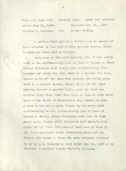
Vol. 216, Page 432. Warranty Deed. Dower released
Dated June 15, 1887.
Recorded July 12, 1887.
William M. Roberts and
- to -
Daniel W. Brewer
Charles C. Morrison
In Eden.
Beginning on the northeasterly side
of the County Road in the northwesterly line of land of
Thomas P. Emery; thence following said County Road south-
westerly five hundred and sixty two (562) feet to a
spotted fir; thence North 42° 30' East, five hundred
and fifty seven (557) feet to a spotted spruce; thence
North 43° 30' East, passing through a spotted birch near
the bank one hundred and sixty four (164) feet, more or
less, to high water mark at the shore of Frenchman's Bay;
thence on same course to low water mark: thence by low
water mark southeasterly to the northwesterly line of
land of Thomas P. Emery; thence following said line to
high water mark: thence still following said Emery line
south 38° 20' West, five hundred (500) feet, more or less,
to the first mentioned bound, containing seven and one
fourth (74) acres.
Being same premises conveyed to said Brewer and
Roberts by Walter R. Hodgkins and John McFarland, by
their warranty deed dated Feb. 9, 1887 and recorded in
the Registry of Deeds for Hancock County Maine, Book
213, Pg. 211.
Vol. 216, Page 432. Warranty Deed. Dower released
Dated June 15, 1887.
Recorded July 12, 1887.
William M. Roberts and
- to -
Charles C. Morrison
Daniel W. Brewer
In Eden.
Beginning on the northeasterly side
of the County Road in the northwesterly line of land of
Thomas P. Emery; thence following said County Road south-
westerly five hundred and sixty two (562) feet to a
spotted fir; thence North 420 30' East, five hundred
and fifty seven (557) feet to a spotted spruce: thence
North 43° 30' East, passing through a spotted birch near
the bank one hundred and ;sixty four (164) feet, more or
less, to high water mark at the shore of Frenchman's Bay;
thence on same course to low water mark: thence by low
water mark southeasterly to the northwesterly line of
land of Thomas F. Emery; thence following said line to
high water mark: thence still following said Emery line
south 38° 20: West, five hundred (500) feet, more or less,
to the first mentioned bound, containing seven and one
fourth (74) acres.
Being same premises conveyed to said Brewer and
Roberts by Walter R. Hodgkins and John McParland, by
their warranty deed dated Fab. 9, 1887 and recorded in
the Registry of Deeds for Hancock County Maine, Book
213, Pg. 211.
Vol. 251, Page 287.
Warranty Deed. Dower released.
Dated June 6, 1891.
Recorded June 8, 1891.
Charles S. Morrison
-to-
Elmer J1 Morrison
First: One half part in common and undivaed of
a certain lot or parcel of land situated in the afore-
said town of Eden and bounded and described in the
whole as follows, to wit:
Beginning on the North Easterly side of the county
road in the North Westerly line of land of Thomas P. Emery
thence following said county road South Westerly five
hundred and sixty two feet to a spotted fir tree, thancê
North forty two degrees thirty minutes East five hundred
and fifty seven feet to a spotted spruce; thence North
forty three degrees thirty minutes East passing through
a spotted birch, near the bank one hundred & sixty four
feet more or less to high water mark at the shore of
Frenchman's Bay; thence on same course to low water
mark; thence by low water mark South Easterly to the
North Westerly line of land of Thomas P. Emery; thence
following said line to high water mark; thence still
following said Emery's line South thirty eight degrees
twenty minutes West five hundred feet more or less to
the first mentioned bound, containing in the whole seven
and one fourth acres, and the whole of sadd lot being the
same described in the deed from Wm. M. Roberts et al. to
said Charles C. Morrison dated June 15, 1887 and recorded
Vol. 251, Page 287.
Warranty Deed. Dower released.
Dated June 6, 1891.
Recorded June 8, 1891.
Charles C. Morrison -to-
Elmer J1 Morrison
First: One half part in common and undivded of
a certain lot or parcol of land situated in the afore-
said town of Eden and bounded and described in the
whole as follows, to wit:
Beginning on the North Easterly side of the county
road in the North Westerly line of land of Thomas P. Emery
thence following said county road South Westerly five
hundred and sixty two feet to a spotted fir tree, thencê
North forty two degrees thirty minutes East five hundred
and fifty seven feet to a snotted spruce: thenco North
forty three degrees thirty minutes East passing through
a spotted birch, near the bank one hundred & sixty four
feet more or less to high water mark at the shore of
Frenchmands Bay; thence on same course to low water
mark; thence by low water mark South Easterly to the
North Westerly line of land of Thomas P. Emery: thence
following said line to high water mark; thence still
following said Emery's line South thirty eight degrees
twenty minutes West five hundred feet more or less to
the first mentioned bound, containing in the whole seven
and one four th acros, and the whole of sadd lot being the
same described in the deed from Wm. M. Roberts et al. to
sail Charles C. Morrisón dated June 15, 1887 and recorded
251 -287
2-
in Hancock County Registry of Deeds, in Book 216, page
432.
Note. other land is also included in this deed.
251 -287
2-
in Hancock County Registry of Deeds, in Book 216, page
432.
Note. other land is also included in this deed.
Vol. 282, Page 95. Warranty Deed. Dower not released.
Dated June 8, 1891.
Recorded July 13, 1894.
Elmer I. Morrison
- to -
Charles C. Morrison
First: One half part in common and undivided
of a certain lot or parcel of land situated in the
aforesaid town of Eden and bounded and described in
the whole as follows to wit:
Beginning on the northeasterly side of the
county road in the northwesterly line of land of
Thomas P. Emery thence following said county road
southwesterly five hundred and sixty two (562) feet,
to a spotted fir, thence north 42° 30' East five
hundred and fifty seven feet to a spotted spruce;
thence North 43° 30' East passing through a spotted
birch, near the bank one hundred sixty four (164)
feet more or less to high water mark at the shore of
Frenchman's Bay: thence on s8me course to low water
mark: thence by low water mark southeasterly to the
northwesterly line of land of Thomas F. Emery; thence
following said line to high water mark; thence still
following said Emery's line south thirty eight degrees
twenty minutes west five hundred feet more or less to
the first mentioned bound, containing in the whole
seven and one fourth acres, and the whole of said lot
being the same described in the deed from Wm. M. Roberts
et al. to said Charles C. Morrison dated June 15, 1887
Vol. 282, Page 95. Warranty Deed. Dower not released.
Dated June 8, 1891.
Recorded July 13, 1894.
Elmer J. Morrison
- to -
Charles C. Lorrison
First: One half part in common and undivided
of & certain lot or parcel of land situated in the
aforesaid town of Eden and bounded and described in
the whole as follows to wit:
Beginning on the northeasterly side of the
county road in the northwesterly line of land of
Thomas F. Emery thence following said county road
southwesterly five hundred and sixty two (562) feet,
to 8 snotted fir, thence north 42° 30' East five
hundred and fifty seven feet to a spotted spruce;
thence North 43° 30' East passing through a spotted
birch, near the bank one hundred sixty four (164)
feet more or less to high water mark at the shore of
Frenchman's Bay: thence on same course to low water
mark: thence by low water mark southeasterly to the
northwestarly line of land of Thomas P. Emery; thence
following said line to high water mark: thence still
following said Emery's line south thirty eight degrees
twenty minutes west five hundred feet more or less to
the first mentioned bound, containing in the whole
sevon and one fourth acres, and the whole of said lot
being the same described in the deed from Wm. M. Roberts
et al. to said Charles C. Morrison dated June 15, 1887
282 - 95
2-
and recorded in Hancock County Registry of Deeds in
Book 216, page 432.
Note.
Other land is also included in this deed.
282 - 95
2-
and recorded in Hancock County Registry of Deeds in
Book 216, page 432.
Note. Other land is also included in this deed.
Vol. 501, Page 192, Warranty Deed. Dower released.
Dated Sept. 8, 1913.
Recorded Sept. 12, 1913.
Charles C. Morrison
-to-
Preston H. Joy
One half part in common and undivided of a
certain lot or parcel of land situated in said town
of Eden bounded and described as follows, to wit:- -
"Beginning on the northeasterly side of the
County Road in the northwesterly line of land of
Thomas P. Emery; thence following said County Road
southwesterly five hundred and sixty two (562) feet
to a spotted fir; thence North 42° 30' East, five
hundred anf fifty seven (557) feet to a spotted
spruce; thence North 43° 30° East, passing through
a spotted birch near the bank one hundred and sixty
four (164) feet, more or less, to high water mark at
the shore of Frenchman's Bay; thence on same course
to low water mark; thence by low water mark south-
easterly to the northwesterly line of land of Thomas
P. Emery; thence following said line to high water
mark; thence still following said Emery line south
38° 20' West, five hundred (500) feet, more or less,
to the first mentioned bound, containing seven and
one fourth (71) acres.
Being the same premises conveyed to William M.
Roberts and Daniel W. Brewer by Walter R. Hodgkins and
John McFarland, by their warranty deed dated Feb. 9,
1887 and recorded in the Registry of Deeds for Hancock
Vol. 501, Page 192, Warranty Deed. Dower released.
Dated Sept. 8, 1913.
Recorded Sept. 12, 1913.
Charles E. Morrison
-to-
Preston II. Joy
One half part in COMLON and undivided of &
certain lot or parcel of land situated in said town
of Eden bounded and described as follows, to wit:-
"Beginning on the northeasterly side of the
County Road in the northwesterly line of land of
Phomas P. Emery: thence following said County Road
southwesterly five hundred and sixty two (562) feet
to & spotted fir; thence North 42° 30' East, five
hundred anf fifty seven (557) feet to a spotted
spruce; thence North 43° 30' Fast, passing through
a spotted birch near the bank one hundred and sixty
four (164) feet, more or less, to high water mark gt
the shore of Frenchman's Bay; thence on same course
to low water mark: thence by low water mark south-
easterly to the northwesterly line of land of Thomss
P. Enery; thence following said line to high water
mark; thence still following said Emery line south
38° 20' West, five hundred (500) feet, more or less,
to the first mentioned bound, containing seven and
one fourth (71) acres.
Being the same premises conveyed to William M.
Roberts and Daniel W. Brewer by Walter R. Hodgkins and
John McFarland, by their warranty deed dated Feb. 9,
1887 and recorded in the Registry of Deeds for Hancock
501 - 192
2-
County Maine, BOOK 213, Page 211, and conveyed by said
Roberts and Brewer to Charles C. Morrison by warranty
deed dated June 15, 1887, and recorded in Book 216,
Page 432 of said Registry.
Said lot being owned in common and undivded in
equal shares by said Charles C. . Morrison and the
Burril National Bank of Ellsworth, Maine.
501 - 192
2-
County Maine, Book 213, Page 211, and conveyed by said
Roberts and Brewer to Charles C. Morrison by warranty
deed dated June 15, 1887, and recorded in Book 216,
Page 432 of said Registry.
Said lot being owned in common and undivded in
equal shares by said Charles C. Morrison and the
Burril National Bank of Ellsworth, Moine.
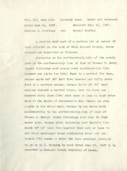
Vol. 213, Page 410. Warranty Deed. Dower not released.
Dated June 16, 1887.
Recorded July 12, 1887.
Charles C. Morrison
-to-
Bryant Bradley
A certain half part of & certain lot or parcel of
land situated in the to will of Eden Hancock County, Maine
bounded and described as follows:
Beginning on the northeasterly side of the county
road in the northwesterly line of land of Thomas P. Emery
thence following said county road southwesterly five
hundred and sixty two (562) feet to a spotted fir tree,
thence north 42° 30' East five hundred and fifty seven
feet to a spotted spruce; thence North 430 30' East
passing through a spotted birch, near the bank one
hundred sixty four (164) feet more or less to high water
mark at the shore of Frenchman's Bay; thence on same
course to low water mark; thence by low water mark
southeasterly to the northwesterly line of land of
Thomas P. Emery; thence following said line to high
water mark; thence still following said Emery's line
South 380 20' West five hundred feet more or less to
the first mentioned bound containing seven and one
fourth (71) acres -- Being the same premises conveyed
to me by W. M. Roberts by deed dated June 15, 1887 to be
recorded in Hancock County Registry of Deeds.
Vol. 213, Page 410. Warranty Deed. Dower not released.
Dated June 16, 1887.
Recorded July 12, 1887.
Charles C. Morrison
-to-
Bryant Bradley
A certain half part of a certain lot or parcel of
land situated in the town of Eden Hancock County, Maine
bounded and described as follows:
Beginning on the northeasterly side of the county
road in the northwesterly line of land of Thomas P. Emery
thence following said county road southwesterly five
hundred and sixty two (562) feet to a spotted fir tree,
thence north 42° 30' East five hundred and fifty seven
feet to a spotted spruce; thence North 430 30' East
passing through a spotted birch, near the bank one
hundred sixty four (164) feet more or less to high water
mark at the shore of Frenchman's Bay: thence on same
course to low water mark: thence by low water mark
southeasterly to the northwesterlyline of land of
Thomas P. Emery; thence following said line to high
water mark; thence still following said Enery's line
South 38° 20' West five hundred feet more or less to
the first mentioned bound containing seven and one
fourth (73) acres -- Being the same premises conveyed
to me by W. M. Roberts by deed dated June 15, 1887 to be
recorded in Hancock County Registry of Doods.
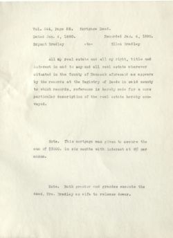
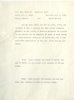
Vol. 244, Page 55.
Mortgage Deed.
Dated Jan. 4, 1890.
Recorded Jan. 4, 1890.
Bryant Bradley
-to-
Ellen Bradley
All my real estate and all my right, title and
interest in and to any and all real estate wherever
situated in the County of Hancock aforesaid as appears
by the records at the Registry of Deeds in said county
to which records, reference is hereby made for a more
particular description of the real estate hereby con-
veyed.
Note. This mortgage was given to secure the
sun of $3000. in six months with interest at 8% per
annum.
Note. Both grantor and grantee execute the
deed, Mrs. Bradley as wife to release dower.
Vol. 244, Page 55.
Mortgage Deed.
Dated Jan. 4. 1890.
Recorded Jan. 4, 1890.
Bryant Bradley
-to-
Ellen Bradley
All my real estate and all my right, title and
interest in and to any and all real estate wherever
situated in the County of Hancock aforesaid as appears
by the records at the Registry of Deeds in said county
to which records, reference is hereby made for & more
particular description of the real estate hereby con-
veyed.
Note. This mortgage was given to secure the
sum of $3000. in six months with interest st 8% per
annum.
Note. Both grantor and grantee execute the
deed, Mrs. Bradley as wife to release dower.
Vol. 245, Page 44. Release Deed.
Dated March 14, 1890.
Recorded March 17, 1890.
Bryant Bradley
-to-
Ellen Bradley
Second. Also one undivded half of another lot
or parcel of land situated in said Eden, bounded and
described as follows, to wit:
Beginning on the North Easterly side of the
County Road in the North Westerly line of land of
Thomas Emery; thence following said County road South
Westerly five hundred and sixty two (562) feet to a
spotted fir tree; thence North forty two degrees
thiry minutes East five hundred and fifty seven feet
to a spotted spruce; thence North forty three degrees
and thirty minutes East, passing through a spotted
birch near the bank one hundred and sixty four (164)
feet, more or less to high water mark at the shore of
Frenchman's Bay: thence on same course to low water
mark; thence by low water mark, southerly to the North
Westerly line of land of Thomas Emery; thence following
said line to high water mark; nthence still following
said Enerys line south thirty eight degrees and twenty
minutes West, five hundred (500) feet, more or less,
to the first mentioned bound, containing seven and one
fourth acres,
Vol. 245, Page 44. Release Deed.
Dated March 14, 1890.
Recorded March 17, 1890.
Pryant Bradley
-to-
Ellen Bradley
Second Also one undivded helf of another lot
or parcel of land situated in said Eden, bounded and
described as follows, to wit:
Beginning on the North Easterly side of the
County Road in the North Westerly line of land of
Thomas Emery: thence following said County road South
Westerly five hundred and sixty two (562) feet to a
spotted fir tree; thence North forty two degrees
thiry minutes East five hundred and fifty seven feet
to 8 spotted spruce; thence North forty three degrees
and thirty minutes East, passing through st spotted
birch near the bank one hundred and sixty four (164)
feet, more or less to high water mark at the shore of
Frenchman's Bay: thence on same course to low water
mark; thence by low water mark, southerly to the North
Westerly line of land of Thomas Emery; thence following
said line to high water mark; thence still following
said Enerys line south thirty eight degrees and twenty
minutes West, five hundred (500) feet, more or less,
to the first mentioned bound, containing seven and one
fourth acres,
Vol. 275, Page 306.
Warranty Deed.
Dated Sept. 23, 1893.
Recorded Sept. 26, 1893.
Ellen Bradley
Bryant Bradley
-to-
Richard F. Chase.
This deed conveys a lot acquired from Hasket
Derby recorded in book 210, pg. 135, and the following.
Also all other lots or parcels of land situated
in said County of Hancock now belonging to or owned
by the said Ellen and Bryant Bradley, for or further
description of said lots or parcels of land reference
is hereby made to deeds of said lots or parcels of
land now recorded with said Hancock County Registry
of Deeds.
All of said premises being conveyed subject
to any and all mortgages which now exist on said
property.
Vol. 275, Page 306.
Warranty Deed.
Dated Sept. 23, 1893.
Recorded Sept. 26, 1893.
Ellen Bradley
Bryant Bradley
-to-
Richard F. Chase.
This deed conveys 8 lot acquired from Hasket
Derby recorded in book 210, PE. 135, end the following.
Also all other lots or parcels of land situated
in said County of Hancock now belonging to or owned
by the said Ellen and Bryant Bradley, for or further
description of said lots or parcels of land reference
is hereby made to deads of said lots or parcels of
land now recorded with said Hancock County Registry
of Deeds.
All of said premises being conveyed subject
to any and all mortgages which now exist on said
property.
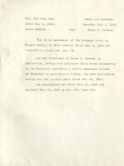
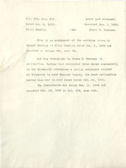
Vol. 266, Page 514.
Dower not released.
Dated Jan. 4, 1890.
Recorded Jan. 6, 1893.
Ellen Bradley
-to-
James E. Parsons.
This is an assignment of the mortgage given by
Bryant Bradley to Ellen Bradley dated Jan. 4, 1890 and
recorded in volume 244, page 55.
And was foreclosed by James E. Parsons by
publication, having been published three weeks sucessively
in the Ellsworth enterprise a public newspaper printed
at Ellsworth in said Hancock County, the last publication
having been had in said paper dated Feb. 28, 1894.
The foreclosure was dated Feb. 12, 1894 and
recorded Feb. 29, 1894 in vol. 278, page 286.
Vol. 266. Page 514.
Dower not released.
Dated Jan. 4, 1890.
Recorded Jan. 6, 1893.
Ellen Bradley
-to-
James E. Parsons.
This is an assignment of the mortgage given by
Bryant Bradley to Kllen Bradley dated Jan. 4, 1890 and
recorded in volume 244, page 55.
And W8 S foreclosed by James E. Parsons by
publication, having been published three weeks sucessively
in the Ellsworth enterprise a public newspaper printed
at Ellsworth in said Hancock County, the last publication
having been had in said paper dated Feb. 28, 1894.
The foreclosure was dated Feb. 12, 1894 and
recorded Feb. 29, 1894 in vol. 278, page 286.
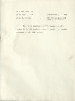
Vol. 283, Page 184
Dated Oct. 2, 1894.
Recorded Oct. 3, 1894.
James E. Parsons
-to-
The Burrill National
Bank of Ellsworth
This is an assignment of the grantors rights
in and to the the mortgage given by Bradley to Bradley
recorded in vol. 244, pg. 55.
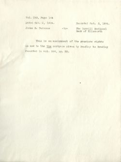
Vol. 283, Page 184
Dated Oct. 2, 1894.
Recorded not. 3, 1894.
James E. Parsons
-to-
The Burrill National
Bank of Ellsworth
This is an assignment of the grantors rights
in and to the the mortgage given by Bradley to Bradley
recorded in vol. 244, pg. 55.
Vol. 502, Page 106. Quit-claim Deed.
Dated Oct. 27, 1913.
Recorded Oct. 31. 1913.
The Burrill National
Bank
-to-
Preston H. Joy
One half part in common and undivided of a certain
lot or parcel of land situated in the town of Eden afore-
said and bounded and described as follows, to wit:
Beginning on the Northeasterly side of the County
Road in the Northwesterly line of land now or formerly
of Thomas P. Emery; thence following said County Road
Southwesterly five hundred and sixty two (562) feet to
a spotted fir tree; thence North 42° 30' East five
hundred and fifty seven (557) feet to a spotted spruce
tree; thence North 43° 30' East, passing through a
spotted birch tree near the bank one hundred and sixty
four (164) feet, more or less to high water mark at the
shore of Frenchman's Bay; thence on same course to low
water mark; thence by low water mark, southeasterly to
the Northwesterly line of land now or formerly of
Thomas P. Emery; thence following said line to high
water mark; thence still following said Emery line
south 38° 20' West, five hundred (500) feet, more or
less, to the first mentioned bound, containing seven
and one fourth (71) acres, more or less.
Vol. 502, Page 106. Quit-claim Deed.
Dated Oct. 27, 1913.
Recorded Oct. 31, 1913.
The Burrill National
Bank
-to-
Preston H. y Joy
One half part in common and undivided of 8 certain
lot or parcel of land situated in the town of Eden afore-
said and bounded and described as follows, to wit:
Beginning on the Northeasterly side of the County
Road in the Northwesterly line of land now or formerly
of Thomas P. Emery; thence following said County Road
Southwesterly five hundred and sixty two (562) feet to
a spotted fir tree; thence North 42° 30' East five
hundred and fifty seven (657) feet to a spotted spruce
tree; thence North 4:30 30' East, passing through a
spotted birch tree near the bank one hundred and sixty
four (164) feet, more or less to high water mark at the
shore of Frenchman's Bay; the nce on same course to low
water mark: thence by low water mark, southeasterly to
the Northwesterly line of land now or formerly of
Thomas P. Emery; thence following said line to high
water mark; thence still following said Emery line
south 380 20' West, five hundred (500) feet, more or
loss, to the first mentioned bound, containing seven
and one fourth (71) acres, more or less.
Vol. 502, Page 107.
Mortgage Deed.
Dower released.
Dated Oct. 27, 1913.
Recorded Oct. 31, 1913.
Preston H. Joy
-to-
The Burrill National
Bank
This is a mortgage of the locus given to secure
the sum of $1100. payable $200. Aug. 1, 1914, $200
Dec. 1, 1914, $700. Aug. 1, 1915 with interest at 6%
per annum.
Does not appear discharged.
No1. 502, Page 107.
Mortgage Deed.
Dower released.
Dated Oct. 27, 1913.
Recorded Oct. 31, 1913.
Preston H. JOY
-to-
The Burrill National
Bank
This is a mortgage of the locus given to secure
the sum of $1100. payable $200. Aug. 1, 1914, $200
Doc. 1, 1914, $700. Aug. I, 1915 with interest at 6%
per annum.
Does not appear discharged.
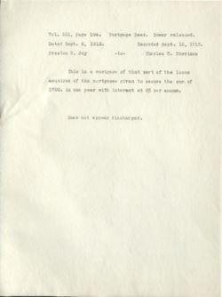
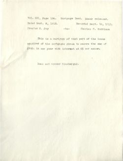
Vol. 501, Page 194.
Mortgage Deed. Dower released.
Dated Sept. 8, 1913.
Recorded Sept. 12, 1913.
Preston H. Joy
-to-
Charles C. Morrison
This is a mortgage of that part of the locus
acquired of the mortgagee given to secure the sum of
$700. in one year with interest at 6% per annum.
Does not appear discharged.
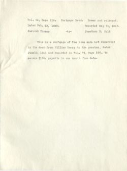
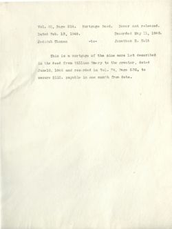
Vol. 82, Page 514.
Mortgage Deed.
Dower not released.
Dated Feb. 13, 1848.
Recorded May 11, 1848.
Jedidah Thomas
-to-
Jonathon R. Holt
This is a mortgage of the nine acre lot described
in the deed from William Emery to the grantor, dated
June10, 1846 and recorded in Vol. 79, Page 536, to
secure $112. payable in one month from date.
Vol. 82, Page 514.
Mortgage Deed.
Dower not released.
Dated Feb. 13, 1848.
Recorded May 11, 1848.
Jedidah Thomas
-to-
Jonathon R. Holt
This is a mortgage of the nine acre lot described
in the deed from William Emery to the grantor, dated
June10, 1846 and recorded in Vol. 79, Page 536, to
secure $112. payable in one month from data.
Vol. 97, Page 10. Warranty Deed. Dower released.
Dated Aug. 22, 1853.
Recorded Sept. 9, 1853.
J. S. Eastes in her
own right and Zachens
Eastes
-to-
John McFarlin
In Eden.
Beginning at John McFarland's Northeast corner
bounds and following his side line to the County road
thence following said road to a stake and stone at the
corner of a fence, thence following said fence to the
sea shore thence following said shore to the first
mentioned bounds containing nine acres more or less,
recorded in Vol. 79, Page 335 of Hancock Registry.
Note in the body of the deed the grantor is recited
as being Jedidah Eastes.
Vol. 79 has been renumbered, page 335 now being
336.
Vol. 97, Page 10. Warranty Deed. Dower released.
Dated Aug. 22, 1853.
Recorded Sent. 9, 1853.
I. S. Eastes in her
own right and Zachena
Eastes
-to-
John McFarlin
In Eden.
Beginning at John McParland's Northeast corner
bounds and following his side line to the County road
thence following" said road to & stake and stone at the
corner of & fence, thenco following said fence to the
sea shore thence following said shore to the first
mentioned bounds containing nine acres more or less,
recorded in Vol. 79, Page 335 of Hancock Registry.
Note in the body of the deed the grantor is recited
as being Jedidah Eastes.
Vol. 79 has been renumbered, page 335 now being
336.

