
From collection Jesup Library JDR Jr. Collection

Page 1
Page 2
Page 3
Page 4
Page 5
Page 6
Page 7
Page 8
Page 9
Page 10
Page 11
Page 12
Page 13
Page 14
Page 15
Page 16
Page 17
Page 18

Page 19
Page 20
Page 21
Page 22
Page 23
Page 24
Page 25
Page 26
Page 27
Page 28
Page 29
Page 30
Page 31
Page 32
Page 33
Page 34
Page 35
Page 36
Page 37
Search
results in pages
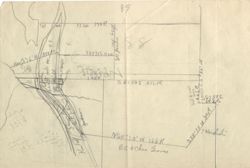
Sound Western Boundary
89
1320 170P,
550
#
584308
mass
you
194P.
S8350E 21212
583582
SRRL
Neglion 166R
Betcher Gares
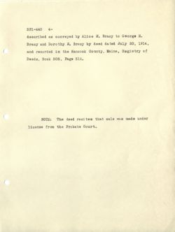
Vol. 531, Page 440. Guardian's Deed.
Dated January 23, 1917.
Recorded January 27, 1917.
Florence E. Blake
Guardian of Dorothy
-to-
Loren E. Kimball
E. Bracy
In Mount Desert.
One-half in common and undivided of the following
described real estate, to wit:
Five certain lots or parcels of land, to ge ther
with all buildings thereon, si tuated in said Mount De-
sert, and bounded and described as follows, to wit:
Lot No. 1: One undivided fourth part of a cer-
tain lot or parcel of land situated on the East side
of Somes's Sound, marked and described on plan made by
James Peters as lot No. 91, containing ninety-six acres,
more or less.
Lot No. 2:- One quarter part of lot ninety one
in common and undivided. Said lot 91 is on the East
side of Somes's Sound in said Mount Desert.
Lot No. 3:- Beginning at a stake set in the
ground one and one half rods from the center of the
town road leading through the Sound district, at the
531-440 2-
Northwest corner of land formerly owned by Sidney P.
Bracy, and runningSouth eighty four degrees East, one
hundred and sixty-five feet to a stake set in the ground;
thence North six degrees East, twenty-one feet to a
stake set in the ground; thence following fence West
one hundred and sixty-five feet to corner post of said
fence; thence South six degrees West, five and one
quarter feet to the place of beginning, containing twenty-
one hundred and sixty six feet, more or less.
Lot No. 4:- Beginning at the Northern line of the
Sidney P. Bracy homestead lot at a stone bound on the
eastern side of the old team road leading from the shore
landing near Sargent's Cove on the eastern side of Somes's
Sound to the so called Southwest Valley; thence following
the southeasterly side of said Southwest Valley road
generally northeasterly to the western line of a lot of
land conveyed to Sidney P. Bracy by Charles H. Frazier
by his deed recorded in Hancook Registry of Deeds in Book
332, Page 526; thence southerly by the western line of
said Frazier lot to the northern line of the Bracy home -
stead lot; the nce Westerly by said line of said homestead
lot to the first mentioned bound, containing two and
531-440 3-
one-half acres, more or less.
Lot No. 5: - All that part of lot numbered 91
on Peter's plan of Mt. Desert made in 1807, and sit-
usted on the eastern side of Somes's Sound, lying
northwardly of a line established by John S. Sargent
and Sidney P. Bracy as a line of partition between
their parts of and appurtenant to said lot, to wit;
Beginning in the middle of the brook running out from
said lot where it enters the water of said Sound, and
following the brook generally easterly between said
Sargent's dwelling place and that of said Bracy to a
point opposite a stone bound near the southern bank of
the brook; thence by the shortest line southerly to
said bound; thence South 52° 30' East, twenty four rods
to a stone bound standing twenty sevenand one half rods
northerly from and in a direction at right angles with
the southern line of said Lot No. 91; thence South 84°
East, but parallel with and twenty seven and one half
rods northerly from said southern line of Lot No. 91,
to the eastern boundary of said lot No. 91.
Meaning and intending herein to include one-half
in common and undivided of all and the same premises
531-440 4-
described as conveyed by Alice M. Bracy to George H.
Bracy and Dorothy E. Bracy by deed dated July 20, 1914,
and recorded in the Hancock County, Maine, Registry of
Deeds, Book 505, Page 515.
NOTE: The deed recites that sale was made under
license from the Probate Court.
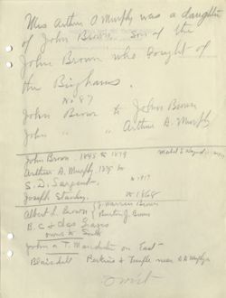
Who arthur a murphy was a daught
O
O
John Brown who fought of
of John Brown, BHT
Sm of the
the Bighams ,
John Bern to John Brun
No 87
John 11 " arthur A. month
mahel S idaynd
John Brown 1845 to 1879
arthur A. Mustly 1879 to
S.D. Sargent,
to 1917
Joseph Stanley
to -1868
J. warren Brown
albert L. Brown
B. C + chas graves
Busting Brams
owns to South
John a T. M andress on has
Blairdell Berkins + Temple near AA mysleys,
omit
1919
1843
7.4
DEPARTMENT OF THE INTERIOR
NATIONAL PARK SERVICE
NATIONAL MONUMENT
OFFICE OF THE CUSTODIAN
,
191
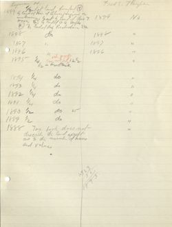
Lyman H.
1899 by land of Him of or
1/2 Lat land bonled N
Fred S. Thoupan
unknown Home govt G land f this y 1899
No
W.
5 G Mulfley
'h land of Buy Rechdin 25a
1898
do
1898
"
1897
",
1897
21
O
1896
1896
"
1895
1/4
" rihe goth
can not Ind 112
4
1/2 in Herofisis
1894
1/4
do
"
1853
1/4
do
"
1892 114
do
11
1891 114
do
11
1890 1/2
do 25
"
1889 1/2
dr
"
1888 Tax book does not
4
as to the much when
discribe the land expiration
and value,
the
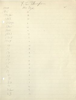
7.5 Thompson
1900
No Tax
1901
"
1902
"
1983
1/
C 1804.
"
1905
"
1906
"
1907
't
1908
"
1909
"
10
"
11
"
12
4
13
"
14
"
15
n
16
"
17
4
is
"
C
19
,
20
(
21
"
22
11
23
"
Lyman H Heris it + 1/2 ht land fonded M land of Ohen
1900 sby Card of a. a, much muth land of
Hyph a inknon, East Gley of Chas Tiltown
Buy Richalse 25a
1901
do
graft N. s land of Pembrke Refjan
1902
do
do
1903
do
graft
do + S. as D. Sayent
1904
do
"
"
1905
be
"
"
1906
11
.
"
"
"
1907
4
"
ee
be
4
1908
/
e
"
"
"
1909
do
1910
"
"
"
"
W. by Transfarm
11
do
12
same eneft E, Gland of stiff fully of there
13
ds
14
do english s Q land of Mabel Hagrane
15
do earth land of C. T.Home
16
do
"
17
"
"
18
n
4
19
n
"
20
"
"
21
R
11
22
"
4
23
h
4
And I do covenant with the said grantee, his heirs
and assigns that I will warrant and forever defend the
prenises to him the said grantee, his heirs and assigns
forever against the lawful claims and demands of all
persons claiming by, through or under me.
3 Pick - -51 Smus to Skinn.(61)
8 " 479
29 me 183
4 met 121
Deeds, Enc 9,
Sales 11 24 -1045
KIMBALL HOUSE
North East Harbor, Maine
Jan. 13, 1922
Mr. George B. Dorr
Bar Harbor, Maine
Dear Mr. Dorr:-
I have bought several lots of land in the Sound district
between North East Harbor, and Somesville. There were about
ten different lots, which were formerly owned by such parties
as Brown, Richardson, Higgins, Sargent, Murphy, Morris, and
others. These people claim they have had the eastern end of
their lots properly bounded for the last seventy or one hun-
dred years. I mean the end that bounds on the land that for-
merely belonged, I think, to the Jordans, and then to the
Howes, and has recently been bought for the Reservation. I
am told that the Reservation has had a survey made, and that
they have run a line that extends well into the lots that
formerly belonged to the original owners, and in fact some
of them belong now to the original owners. I have also been
told that a lot of fifty scres, which formerly belonged to
Murphy, and which I bought from Bracy has been cut in two,
and that twenty acres have been taken off of it by the Reser-
vation, and that it will take much more from a lot that I
bought, which formerly belonged to Morris.
Mr. Lynam, who seems to be an agent for the Reservation,
thought the man, who had made the survey, had not gone far
enough to the west. I do not know how much more he would
have taken, but I told him that if they had taken much more
there would not have been much left to the original owners.
The original owners claim that the bounds are well de-
fined by bolts, piles of stones, and spotted trees.
I intende to have gone over my purchases last fall, but
the snow came on so suddenly I did not have time. It seems
to me a rather peculiar condition for the Reservation to be
trying to take so much land from SO many people, who have
held the land so long, and have always agreed upon the line
they now claim to be well established.
- 2 -
My experience in life has taught me to deal with people
a little differently than the representatives of the Reservation
seem to have dealt with the land owners at the Sound. When I
find a difference of opinion between landowners about titles
or bounds I attempt to adjust the difference as soon as I can,
as I want to be on the best of terms with the party that owns
the property next to mine, and I should think the people who
control the Reservation would be more than anxious to be on
the best of terms with all the people of the island. It seems
to me that if the Reservation is to be a success it must have
the help and co-operation of all the people.
Now I know that the running of this line, as it has been
run, has caused more hard feeling on this island than any
other one thing I have heard of here in my whole life. For
one thing have been told, and I think it is true, that more
deer have been killed on the island this last fall than for a
long time. I am also told by one man that he was told that
one person had killed six. I have heard from both the origi-
nal and present owners of land in the Sound district remarks
which I do not think it would be advisable to repeat, but which
are exceedingly bitter toward those in charge of the Reservation.
About thirty years ago the Road Commissioner of IV. E. Harbor
undertook to locate the town roads in the whole village, but
after running with a surveyor a few days and finding that they
were running through and on the wrong side of some houses,
and through the Rock End Hotel, it was decided to establish
the lines on the location of the old road.
I have always found in the settlement of boundary disputes,
that when the whole community is united, as it is in this case,
and the bounds, and monuments to prove they are right, as they
claim they have in this case, that they are likely to prevail,
and the other side is likely to lose.
It seems to me that even though the Reservation may think
that they are technically right they would rather "give in"
than to get the ill will of SO many people. It seems to me
the only fair way to adjust this controversy is to take the
old lines that have been established and undisputed so long.
Very truly yours,
Le. E. Kimbau
LEK/MMK
DEPARTMENT OF THE INTERIOR
NATIONAL PARK SERVICE
LAFAYETTE NATIONAL PARK
BAR HARBOR, MAINE
OFFICE OF THE SUPERINTENDENT
January 21 , 1922.
Mr. L. E. Kimball.
Northeast Harbor, Me.
Dear Mr. Kimbail:
I have just received your letter of January 13th
with regard to the boundary between lands you have lately
purchased and those of the National Park.
Personally I know nothing of this boundary. The
Government desires no land to which it can not show just
claim; I have no right or nower to alienate from its owner-
would
ship land to which it is entitled, nor you wish to take such
land. Where land has remained until now uncleared and un-
cultivated. and has none other than a forest value, bound-
aries in this region are ant to be obscure so far as land-
marks go. Where a stone bound was erected, as was generally
the case where boundaries were regarded & S important, there
is no difficulty in obtaining clear starting points for the
descriptions shown in doods; but where location was establish-
ad by marke out on trees, these are apt to vanish, and momory
of location in such oi rounstance is doubtful and soon lost.
ROTART 70 THEMTRA930
JANOITAN
Mr. L. B. K.
JANOITAN
1- 21-22
MAIN ,ROBRAH RA8
3HT 70
Which is the case in the present instance I have no means
of telling at this time, nor, as I understand your letter,
have you. All that we can do under these circumstances is
to employ a good surveyor and have the line run out, ob-
taining all the evidence we can from local sources that
might cast light on it. This I will gladly co-operate with
you in doing as so on as I have funds which I can use for
such purpose.
I am glad to have the information that you send me
in re gard to the illegal slaughter of deer unon the Island.
This is a State matter, and the State Fish and Game Com-
missioner will be glad to got your statement, which I will
forward.
Yours truly,
GBD-M
DEPARTMENT OF THE INTERIOR
NATIONAL PARK SERVICE
SS-IS:-
LAFAYETTE NATIONAL PARK
.8 .I all
BAR HARBOR, MAINE
OFFICE OF THE SUPERINTENDENT
a FRESH are and I constant ent at 0080 and at dolan
Tetter error bastero.net I 8.0 ,IOLS all da To
at seonstemmerto esent of IBB ew tait IIA even
-do two STATE anti end even fnis TOYOTING 5003 B at
tait Cooof mort ew somebile edt I.S. gainted
dillw . filw I alet .#1 no 3800 $ dain
rot 980 ABO I dolnw about ever I as NO OB 88 artic ni MON
.08 oqze doss
on bures DOY tart e every of balg MLB I
edt Mons 2005 20 Sagefit edit of Banger at
-moo sean but 5817 state out fitte ,TOSTEL eta$8 B at aldT
fitw I no ri w ,tremotats THOV Joy of baby ed Iftw Tedro to alm
BYUCY
&s w
cari
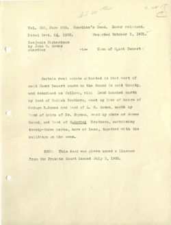
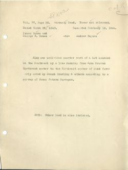
Vol. 365, Page 505. Guardian's Deed. Dower released.
Dated Sent. 26, 1900.
Recorded October 1, 1901.
Benjamin Richardson
by John W Somes
guardian
-to-
Town of Mount Desert
Certain real estate situated in that part of
said Mount Desert known as the Sound in said County,
and described as follows, viz: Land bounded north
by land of Rodick Brothers, east by land of heirs of
Geroge B. Somes and land of L. H. Somes, south by
land of heirs of Dr. Haynes, west by shore or Somes
Sound, and land of Roderick Brothers, containing
twenty-three acres, more or less, together with the
buildings on the same.
NOTE: This deed was given under a license
from the Probate Court issued July 3, 1900.
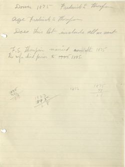
Dower 1875 Fredwich S throufor
age Freding S thompson
Does this lot include all we want
F.S. Thompson married soon/after 1875
his wife died prior to 19051895.
1895
1875
1856
5Y
his
2
100
99
77-36
102-519
97 114,A,H,
104-246
VA
1151 "wilend
96
102-519
108-20 all Haywood
abot
95
more
117-309
Q
137-149
94 ITSOB to 117-309
187-341
15-11
93 lynn 851-163
219-134
SafE
92 4/A/14 8+8n
185-54
bo.s.c.w. 219-134
91
1/2 andres Hay 59.2 14-86
negart
162-153
90
Siles Sayed
565-505
Sq andrew Hayming this Highin 207-538 19-194
podich P.O.
Fs mt-Out
VigAit,
See
496-4540 455 ad,
99-217
162-155
musply
14-31
531-440-V43
thas
175-112
702-419
bonded on its
1075388
115-193
116-123
2 Park
S Reserve
wh th build
t by
fouly
mp
mide
care
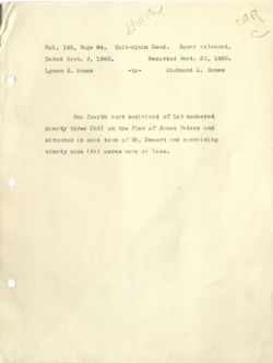
Vol. 185, Page 84. Quit-claim Deed.
Dower released.
Dated Sent. 9, 1882.
Recorded Sept. 23. 1882.
Lyman H. Somes
-to-
Richmond L. Somes
One fourth part undivided of lot numbered
ninety three (93) on the Plan of James Peters and
situated in said town of Mt. Desert and containing
ninety nine (99) aores more or less.
Dec 3, 10:30
Somes
Issec
Geo.B
Lyman H
look at index for company
RichmondL
from Nov. 27 1923 the 3,
Mary B
Chas E
Somes Sio A
Indupe and attachment
Fred . from NoN. 27 1923 4Dec 3
L ethicign Della C
Index tollarts
Medilla C
from NN 27, toDic 3
Carolin Medella
Haynis Andrew
)
Index tallada
andrew a from Nov 27 to
Dec 3
Chas
Sarah
King Susie B
7/5 Dec 3.
Thompoon Fred Index from Nev.22
to Die 3.
11/20 123
HWD
C
all
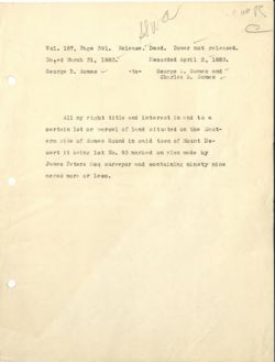
Vol. 187, Page 391. Release. Deed. Dower not released.
Dated March 31, 1883.
Recorded April 2, 1883.
George B. Somes
-to-
George A. Somes and
Charles E. Somes
All my right title and interest in and to a
certain lot or parcel of land situated on the East-
ern side of Somes Sound in said town of Mount De-
sert it being lot No. 93 marked on nlan made by
James Peters Fsq surveyor and containing ninety nine
acres more or less.
dwa
C at
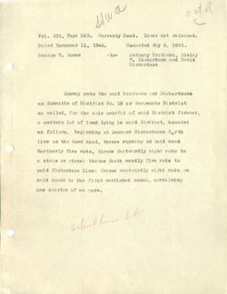
Vol. 251, Page 163. Warranty Deed. Dower not released.
Dated November 11, 1846.
Recorded May 5. 1891.
George B. Somes
-to-
Anthony Brothers, Sibley
P. Richardson and David
Richardson
Convey unto the said Brothers and Richardsons
as Committe of District No. 18 or Sargeants District
so called, for the sole benefit of said District forever,
a certain lot of land lying in said District, bounded
as follows, Beginning at Leonard Richardsons North
line on the town road, thence running on said road
Northerly five rods, thence Eastwardly eight rods to
a stake or stone: thence South wardly five rods to
said Richardson line: thence westwardly eight rods on
said bound to the first mentioned bound. containing
one quarter of an acro.
school how W
Hina
cat I
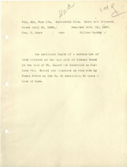
Vol. 219, Page 134. Quit-claim Deed. Dower not released.
Dated April 20, 1882.
Recorded Sept. 19, 1887.
Geo. B. Somes
-to-
William Murphy
V
One undivided fourth of a certain lot of
land situated on the East side of Somesos Sound
in the town of Mt. Desert and described as fol-
lows Viz: Marked and described on plan made by
James Peters as lot No. 91 containing 96 acres -
more or less.
50ml
C
call
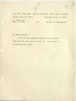
Vol. 137, Page 149. Quit-claim Deed. Dower not released.
Dated March 23, 1870.
Recorded Sent. 9. 1870.
I. Somes and
Geo. B. Somes
-to-
George it. Richardsom
In Mount Desert.
It being lot numbered ninety two on Peters
plan and the same lot on which the said George ii.
Richardson now lives.
carr
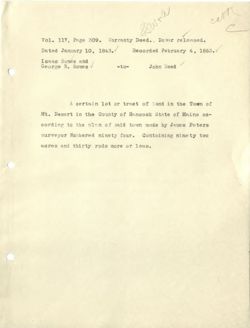
Vol. 117, Page 309. Warranty Deed.. . Dower released.
Dated January 10, 1843.
Recorded February 4, 1863.
Isaac Some8 and
George B. Somes
-to-
John Reed
A certain lot or tract of land in the Town of
Mt. Desert in the County of Hancock State of Maine ac-
cording to the plan of said town made by James Peters
surveyor Numbered ninety four. Containing ninety two
acres and thirty rods more or less.
not & w aw
catis
&
C
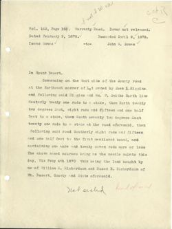
Vol. 162, Page 156. Warranty Deed. Dower not released.
Dated February 9, 1878.
Recorded April 9, 1878.
Isaac Somes
-to-
John W. Somes
In Mount Desert.
Commencing on the West side of the County road
at the Northeast conner of Lot owned by Eben L. Higgins.
and following said Higgins and Wm. P. Smiths North line
Westerly twenty one rods to a stake, then North twenty
two degrees East, eight rods and fifteen and one half
feet to a stake, then South seventy two degrees East
twenty one rods to a stake at the road aforesaid, then
following said road Southerly eight rods and fifteen
and one half feet to the first mentioned bound, and
containing one acre and twenty seven rods more or less
The above named courses being as the needle points this
day, Viz Feby 4th 1870 this being the land bought by
me of William S. Richardson and Susan B. Richardson of
Mt. Desert. County and State aforesaid.
not sealed
hand form
Alwa
card
Vol. 102, Page 519. Warranty Deed. Dower not released.
Dated December 6, 1845.
Recorded October 18, 1856.
Isaac Some8, George B.
Somes and Andrew H.
Haynes
-to- Anthony Brothers
Certain lots or parcels of land. lying or being
in the Town of Mount Desert in the County of Hancock
and State of Maine and numbered ninety six and ninety
eight, containing two hundred and four acres, and one
hundred rods, more or less, according to & survey and
nlan of said Town by James Peters Surveyor, with all
the privileges and appurtenances thereunto belonging.
no seal after andrew It Haynes
signature
cat R
C
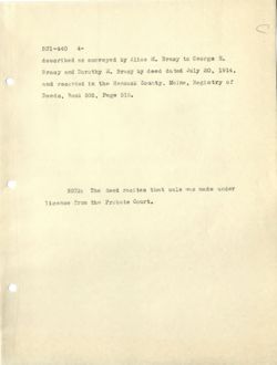
Vol. 531, Page 440. Guardian's Deed.
Dated January 23, 1917.
Recorded January 27, 1917.
Florence E. Blake
Guardian of Dorothy
V
-to-
Loren E. Kimball
E. Bracy
In Mount Desert.
One-half in common and undivided of the following
described real estate, to wit:
Five certain lots or parcels 0 i land, toge ther
with all buildings thereon, situated in said Mount De-
sert, and bounded and described as follows, to wit:
Lot No. 1: One undivided fourth part of a cer- -
tain lot or parcel of land situated on the Last side
of Somes's Sound, marked and described on nlan made by
James Peters as lot No. 91, containing ninety-six acres,
more or less.
Lot No. 2:- One quarter part of lot ninety one
in common and undivided. Said lot 91 is on the East
side of Somes's Sound in said Mount Desert.
Lot No. 3:- Beginning at a stake set in the
ground one and one half rods from the center of the
town road leading through the Sound district, at the
531-440 2-
Northwest corner of land formerly owned by Sidney P.
Bracy. and runningSouth eighty four degrees East, one
hundred and sixty-five feet to a stake set in the ground;
thence North six degrees East, twenty-one feet to a
stake set in the ground; thence following fence West
one hundred and sixty-five feet to corner post of said
fence; thence South six degrees West. five and one
quarter feet to the place of beginning, containing twenty-
one hundred and sixty six feet, more or less.
Lot No. 4:- Beginning at the Northern line of the
Sidney P. Bracy homestead lot at a stone bound on the
enstern side of the old team road leading from the shore
landing near Sargent's Cove on the eastern side of Somes's
Sound to the 30 called Southwest Valley; thence following
the southeasterly side of said Southwest Valley road
generally northeasterly to the western line of a lot of
land conveyed to Sidney P. Bracy by Charles H. Frazier
by his deed recorded in Hancock Registry of Deeds in Book
332, Page 526; thence southerly by the western line of
said Frazier lot to the northern line of the Bracy home-
stead lot; the nce Westerly by said line of said homestead
lot to the first mentioned bound, containing two and
531-440 3-
one-half acres, more or less.
Lot No. 5: - All that part of lot numbered 91
on Peter's plan of Mt. Desert made in 1807, and sit-
unted on the eastern side of Somes's Sound, lying
northwardly of a line established by John S. Sargent
and Sidney P. Bracy as a line of partition between
their parts of and appurtenant to said lot, to wit;
Beginning in the middle of the brook running out from
said lot where it enters the water of said Sound, and
following the brook generally easterly between said
Sargent's dwelling place and that of said Bracy to a
point opposite a stone bound near the southorn bank of
the brook; thence by the shortest line southerly to
said bound; thence South 520 30' East, twenty four rods
to a stone bound standing twenty sevenand one half rods
northerly from and in a direction at right angles with
the southern line of said Lot No. 91; thence South 84°
East. but parallel with and twenty seven and one half
rods northerly from said southern line of LoteNo. 91,
to the eastern boundary of said lot No. 91.
Meaning and intending herein to include one-half
in common and undivided of all and the same premises
531-440 4-
described as conveyed by Alice 11. Bracy to George H.
Bracy and Dorothy E. Bracy by deed dated July 20, 1914,
and recorded in the Hancock County, Maine, Registry of
Deeds, Book 505, Page 515.
NOTE: The deed recites that sale was made under
license from the Probate Court.
cath
sswta
C
Vol. 77, Paga 36. Warranty Deed. Dower not released.
Datad March 28, 1843.
Recorded February 15, 1844.
Isanc Somes and
George B. Somes
-to-
Andrew Haynes
Also one undivided quarter part of a lot bounded
on the Southwest by a line running from John Browns
Northeast corner to the Northwest corner of land form-
erly owned by Enoch Spurling & others according to a
survey of James Peters Surveyor.
NOTE: Other land is also included,
Birglancie to
see eabst
It to 114 (FH)
77-36
anthony Brothers
=
2.2
Antiony this list softhere hoy (Pray)
1847-1553
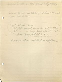
Isaac Someo in 1805 Married Sally Kittridge
Isaac Somes was leth of of ahaham Hands.
form Feb. 5.1781
caft Aham Somes
2d child named been form Feb 14, 1803
3d
44
11 Everge Batson " July 19. 1810
Isaac Somes did Oct 2 1875
Learing Syman Halone e only his
Vol 117-309 shows Charlette B. as wife effree
Viewer Controls
Toggle Page Navigator
P
Toggle Hotspots
H
Toggle Readerview
V
Toggle Search Bar
S
Toggle Viewer Info
I
Toggle Metadata
M
Zoom-In
+
Zoom-Out
-
Re-Center Document
Previous Page
←
Next Page
→
Sound Western Boundary
Details
In Copyright - Rights-holder(s) Unlocatable or Unidentifiable

