
From collection Jesup Library JDR Jr. Collection

Page 1
Page 2
Page 3
Page 4
Page 5
Page 6
Page 7
Page 8
Page 9
Page 10
Page 11
Page 12
Page 13
Page 14
Page 15
Page 16
Page 17
Page 18
Page 19
Page 20
Page 21
Page 22
Page 23
Page 24
Page 25
Page 26
Page 27
Page 28
Page 29
Page 30
Page 31
Page 32
Page 33
Page 34
Page 35
Page 36
Page 37
Page 38
Page 39
Page 40
Page 41
Page 42
Page 43
Page 44
Page 45
Page 46
Page 47
Page 48
Page 49
Page 50
Page 51
Page 52
Page 53
Page 54
Page 55
Page 56
Page 57
Page 58
Page 59
Page 60
Page 61
Page 62
Page 63
Page 64
Page 65
Page 66
Page 67
Page 68
Page 69
Page 70
Page 71
Page 72
Page 73
Page 74
Page 75
Page 76
Page 77
Page 78
Page 79

Page 80
Page 81

Page 82
Page 83

Page 84
Page 85
Page 86
Search
results in pages
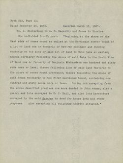
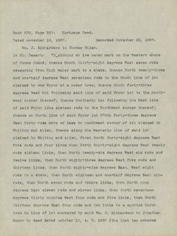
not important. West side Sound - might affect Halls Quarry
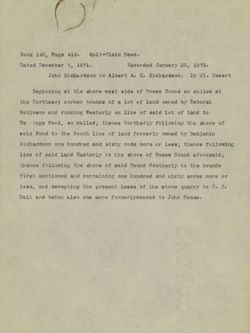
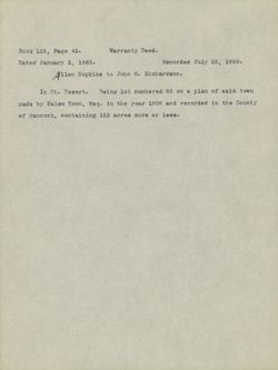
Book 140, Page 416. Quit-Claim Deed.
Dated December 5, 1871.
Recorded January 22, 1872.
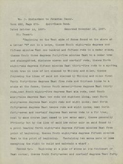
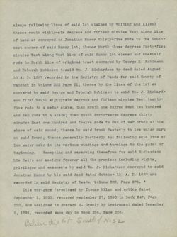
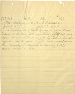
John Richardson to Albert A. K. Richardson. In Mt. Desert
Beginning at the shore west side of Somes Sound so called at
the Northeast corner bounds of a lot of land owned by Deborah
Robinson and running Westerly on line of said lot of land to
Demmings Pond, so called; thence Northerly following the shore of
said Pond to the South line of land formerly owned by Benjamin
Richardson one hundred and sixty rods more or less; thence following
line of said land Easterly to the shore of Somes Sound aforesaid;
thence following the shore of said Sound Southerly to the bounds
first mentioned and containing one hundred and sixty acres more or
less, and excepting the present lease of the stone quarry to C. J.
Hall and being also one acre formerlydeeded to John Somes.
2014 03/35 2008
128. header
area s boist
320080 ... StedIA or and
the bollar 04 tempo to abia toow gross 923 de
detroit 5.0 bourd Disney to JOL is to abalisi and
of boar to dol bine to 3515 110 baine in the
s disabroller sbotter 02 day are
it staell 1 barney bast :20 east ct 3069 bise
jasel to abus barbarot dec mobilisito
63000 mm arone 07 bill bill to
set bites 4.6 storia antwolted
TO 9703 saxia have bachmar birs benefits
93002 gin to ocaal one trail
cancel 63 STOS ero 6516 anted bish
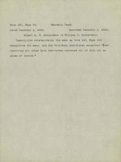
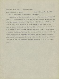
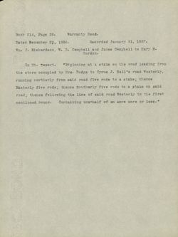
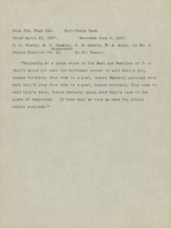
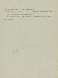
Book 197, Page 94.
Warranty Deed.
nated December 1, 1884.
Recorded December 1, 1884.
Albert A. K. Richardson to William J. Richardson.
Description substantially the same as Book 140, Page 416.
Exceptions the same, and the following additional exception "Also
reserving all other lots heretofore conveyed out of this lot as
shown of record. "
stoot
the
submitted in 03 restructors st traditi
2956 2007 3.8 248 bill kilal trail
6.98 gift
to the DD ite
7.5 remedia
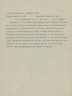
Book 141, Page 299.
warranty Deed.
Dated January 10, 1865.
Recorded January 10, 1872.
John G. Richardson to A. J. Whiting.
In Mt. Desert.
"Beginning at the county road leading from Mt. Desert to Tremont
on the North line of land owned by Jacob somes and following said
line Westerly to Deming's Pond, so called; thence following the
shore of said Pond Northerly to line of land owned by Henry H.
Robinson; thence following said line Easterly to the county road
aforesaid; then following said road Southerly to the place of begin-
ning, containing 20 acres more or less, and being the Westerly part
of lot No. 52 on a plan of Mt. Desert made A. D. 1808 by Salem
Town Jr. Esq. ad recorded in the County of Hancock.
.00g 9729
2 VISOR beth
to man
03 bany eill the
but chost beaute birth 70 bull school
gift wonders 06. do 4642
lo barin been to 6011 of 5dos to
within 6.3 3689 301401161 incomided
matted to 95614 and 65 5505 bise patrelian 9567
0.10 rated 19381 TO D9 parto
2001 absor 719357 . de 1949 e etc 151 to
to edition 9.13 or Bet st mode
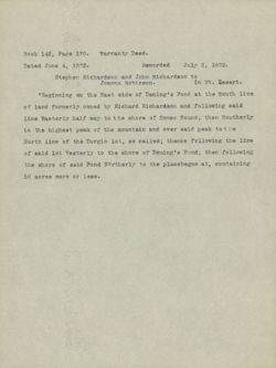
Book 142, Page 170. Warranty Deed.
Dated June 4, 1872.
Recorded
July 2, 1872.
Stephen Richardson and John Richardson to
Joanna Robinson.
In Mt. Desert.
"Beginning on the East side of Deming's Pond at the South line
of land formerly owned by Richard Richardson and following said
line Easterly half way to the shore of Somes Sound; then Southerly
to the highest peak of the mountain and over said peak to he
North line of the Durgin lot, so called; thence following the line
of said lot Westerly to the shore of Deming's Pond; then following
the shore of said Pond Northerly to the placebegun at, containing
50 acres more or less.
,heert know 930 does
-SYAL
behropez
VS and
2 Birp
199368 and
61
seed I 100 2.0 bart 40. taxi 5.18
bind bis basis 0
10.9 from asno? to 920.56 tiert sett
a pot strog bread 7910 have to sleep duesi thist to
ada enticility resiled 03 ,** gill to enti $370.00
Animalist taris stanford to group ords 63 tos atna for
95.5 washaosly back bika to more and
60352 to 300m DC,
day
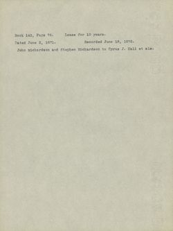
Book 143, Page 76.
Lease for 10 years.
Dated June 2, 1871.
Recorded June 18, 1872.
John Richardson and Stephen Richardson to Cyrus J. Hall et als.
01 96% 94697
137 ,CMI your
SINCE s 79767
am 0.7 reducia Gue rider
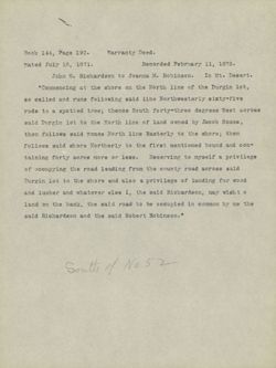
Book 144, Page 190.
Warranty Deed.
nated July 16, 1871.
Recorded February 11, 1873.
John G. Richardson to Joanna M. Robinson. In Mt. Desert.
"Commencing at the shore on the North line of the Durgin lot,
so called and runs following said line Northwesterly sixty-five
rods to a spotted tree; thence South forty-three degrees West across
said Durgin lot to the North line of land owned by Jacob Somes ;
then follows said Somes North line Easterly to the shore; then
follows said shore Northerly to the first mentioned bound and con-
taining forty acres more or less. Reserving to myself a privilege
of occupying the road leading from the county road across said
Durgin lot to the shore and also a privilege of landing for wood
and lumber and whatever else I, the said Richardson, may wish t o
land on the bank, the said road to be occupied in common by me the
said Richardson and the said Robert Robinson."
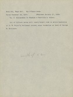
South of No 52
3729
9
in contrustory
card eat st and to and
bido adidas bas 651180 as
3309 is st 850,
scart to because bost 08.1 62361 bine
are 02 and directions 8386 ewester heads
-800 Stre, benefits tarts and er Storia btps over 50.
6 0.8 material 76. 8700 92508
blue bear Synico own bank to
cope 201 to mg. JOE
only sats sended
as bach feb 9.00 and de bres
control 6256 error bill houstandez bloo
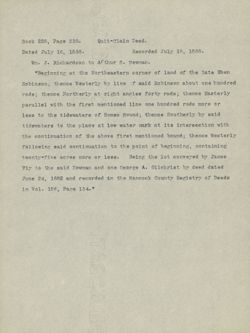
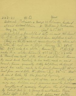
Book 145, Page 450.
Warranty Deed.
Dated November 17, 1873.
Recorded November 29,v1873.
William J. Richardson and Albert A. K. Richardson to
Cyrus J. Hall.
In Mt. Desert.
"Beginning at the road leading from the county road to Hall's
granite quarry at a stake and stone, and runs North twelve degrees
West fourteen rods to a pine tree; thence North forty degrees East
sixteen rods to a large rock with an iron bolt in it; thence on
same course five rods to a birch tree; thence South fifty-three
degrees East thirty-two rods to said road at a stake; then follow-
ing said road Westerly forty-two rods to the first mentioned bound,
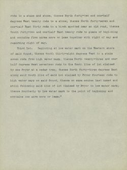
containing four acres more or less.
Second Lot.
Commencing at a stake and stone on the above
named road and runs North nine degrees West thirty-five rods to a
pine stub; then North twenty-eight degrees East ten rods to a poplar
tree; then South forty-nine degrees East twenty rods to a stake and
stump; thence South twenty-nine degrees East sixteen rods to a pine
tree; thence South seven degrees Eastsixteen rods to a hackmatack
tree at the road; then follows said road Westerly twenty-four rods
to the first mentioned point and contains five acres more or less.
The courses given above are as per compass at this date. "
.beer
betressif .6.81
brea
15.01
02 5809 S st 12346£
avkin 2517 3.8 tan glass
SEAL 02 abou desi
tina want DA 51002 5665
583465 somettic 3070 eliar grin
day herr the
are w 9507 one - 42502 beca bigs 902
to 2005 100
overs 5/2 STO made box 2.28 .301 540982
2.97 boor 2891 assayed pomen
is 5.5 eper bed ther I birth
0.1 tuer douce
and - who and eserval agreed
phot moves suggifi
was 6500 otop 1983 3112
the arou antoy
"with is 750 as with
Book 145, Page 452.
Warranty Deed.
Dated November 17, 1873.
Recorded November 29, 1873.
Wm. J.and Albert A. K. Richardson to Cyrus J. Hall.
In Mt. Desert.
"Commencing at the Western line of the granite lease at a stake
on the South side of the road leading from the granite quarry to
the county road and follows said road Westerly eighty rods to a
bluff ledge with an iron bolt in it; then from said bolt South
five degrees East sixty rods to an iron bolt in the ledge at the
North line of lot owned by Deborah Robinson; then follows said
North line Easterly to the West line of said granite lease; then
following said West line Northerly to the first mentioned bound and
contains thirty acres more or less. Also a right of way across
the above mentioned granite lease where the road (that he, the said
Hall, has built this fall) is located."
.6897
to: radhevan 60590598 68881
st C. bos.
padel all 96 anti with VIS, the
32.00 BIG 5807 ord to abia
shop ebos Vinochely heer 62.88 21h
bise LOST 121 1500 card eabed
sh at Item bones abct 8892595 4219
lokes helly betwe To eatt
redt bind to spit 0227 9.45 08 9417
was bobes benuition 63 5711 bibe
Radina V6, w ORIA 48851 30 9708 88761
6top and back 9112 gerol store
4.5 Stapolist
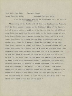
Book 148, Page 341.
Warranty Deed.
Dated June 22, 1874.
Recorded June 24, 1874.
A. A. K. Richardson and Wm. J. Richardson to A. J. Whiting
and Obadiah Allen.
"Commencing on the North side of the road leading from Deming's
Pont to Halls granite quarry on the Northeast line of the Western
lot of granite which we sold to C. J. Hall in the fall of 1873 and
runs following said line Northwesterly to the North corner of said
lot; thence North twenty-seven degrees West four rods to a birch
tree; then North forty=five degrees East seventy=two rods to a
poplar tree; then North seventy-threeddegrees East twelve rods;
then South twenty-four rods; then South forty=five degrees East ten
rods; then south forty-eight rods ta a stake at the said road; then
following said road Westerly seventeen rods to a hackmatack tree
on the East line of another lot sold by us to the said C. J. Hall
in the fall of 1873; then follows said road Westerly ten rods more
or less to the first mentioned bound.
Excepting from this con-
veyance a certain lot within the above described lines which we
sold and conveyed to the said C. J. Hall in 1873. The above
described lot contains eighteen acres more or less. Reserving to
ourselves a right of way across said lots and granting to them,
the said whiting and Allen, a right of way to the shore and to the
above named road across any of our land."
Just
and 4760
15881
,88
study BCJ 57012
.
409/1A 500
more to ebite one to
the to outf did ,170 ejipers 65857 of
pas EASI to bica stiness to 961
testo 9812 introdiot am
9967 showed depositphotos
355793 9732 3509 gard
abir selent 19798 gord 19978
9917 tes search petsy 950
to state net 3560 Heron 8002
4.65 abov 5807 0259
binging 9508 161 YD, to 19.85 sta
119.3 back hine news to ILDS the
morg paj beared terio bod at 8051 TO
the dold asalt bediculars avoid sr. subsidity 0.01 2 pecan st
event st 6186 83/3 is one pica
743659 ..... 76 25755 controls JOJ
6gg ajoi bing a MONISATION
345 02 bits brode of the to gas groups 6185 sig
the avoid
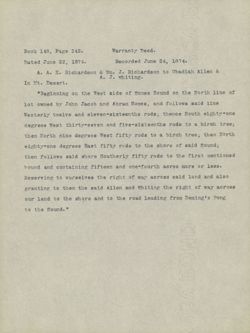
Book 148, Page 342.
Warranty Deed.
Dated June 22, 1874.
Recorded June 24, 1874.
A. A. K. Richardson & Wm. J. Richardson to Obadiah Allen &
A. J. whiting.
In Mt. Desert.
"Beginning on the West side of Somes Sound on the North line of
lot owned by John Jacob and Abram Somes, and follows said line
Westerly twelve and eleven-sixteenths rods; thence South eighty-one
degrees West thirty-seven and five-sixteenths rods to a birch tree;
then North nine degrees West fifty rods to a birch tree; then North
eighty-one degrees East fifty rods to the shore of said Sound;
then follows said shore Southerly fifty rods to the first mentioned
bound and containing fifteen and one-fourth acres more or less.
Reserving to ourselves the right of way across said land and also
granting to them the said Allen and Whiting the right of way across
our land to the shore and to the road leading from Deming's Pong
to the Sound."
OF
best
HAS 980
out st
the 60002 509403 if
plad brea dobet to becoro JEE
09003 raper Dies oviero
abor kno casy
78543 S 02 3003 test
6268 white 9.17 CI, abili tabs 4089396 sho- step is
38913 and of shot grade bind 199
,70 Heyes egre bru first
bain the Birth Blee hachos gary sevisardo 0.3 polyteens
10752 VAX to bire bike Bit made 0.2
pent Date 954 02 bre edd of bass have
"ahaves
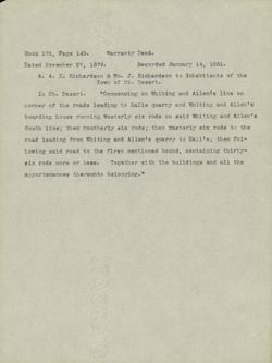
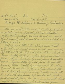
Book 175, Page 143.
Warranty Deed.
Dated November 27, 1879.
Recorded January 14, 1881.
A. A. K. Richardson & Wm. J. Richardson to Inhabitants of the
Town of Mt. Desert.
In Mt. Desert.
"Commencing on Whiting and Allends line on
corner of the roads leading to Halls quarry and Whiting and Allen's
boarding house running Westerly six rods on said Whiting and Allen's
South line; then southerly six rods; then Easterly six rods to the
road leading from Whiting and Allen's quarry to Hall's; then fol-
lowing said road to the first mentioned bound, containing thirty-
six rods more or less. Together with the buildings and all the
appurtenances thereunto belonging."
4241 7008
heb coah Nergi HYS Technique
5.45 20 eig
the
and
als bus ac actories $8.2
the
the getting one exten 63 abost to the the
how his 110 when
and to 800% xr blandery hadd 78607 ate may
0.0 BNB gathrel bank
395 Item subject been bton grinds
gill, ALL ..... to sro abou the
376150 st
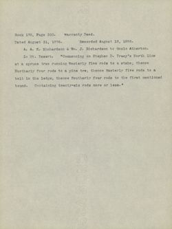
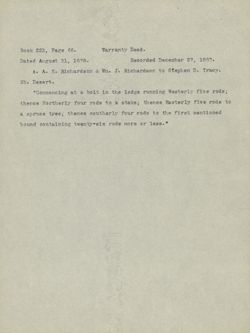
Book 178, Page 308.
warranty Deed.
Dated August 31, 1878.
Recorded August 18, 1886.
A. A. K. Richardson & Wm. J. Richardson to Onzlo Atherton.
In Mt. Desert.
"Commencing on Stephen D. Tracy's North line
at a spruce tree running Westerly five rods to a stake; thence
Northerly four rods to a pine tre; thence Easterly five rods to a
bolt in the ledge; thence Southerly four rods to the first mentioned
Containing twenty-six rods more or less.
"
bound.
100,
.000 2655
.388$ ,SI was ,10 be
65810 and
enis
2 06 ghost min 4597 900705
16 to phot avi) angeles 02 seon
beneigher Jay19 977 08 abca 9807 205 908917 763697 nit Start
"48861 96 9702 8605 should
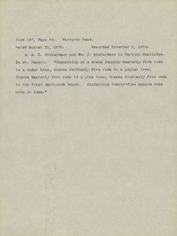
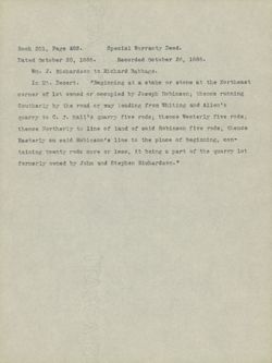
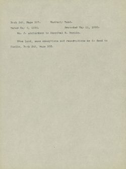
Book 197, Page 60. Warranty Deed.
Dated August 31, 1878.
Recorded November 8, 1884.
A. A. K. Richardson and Wm. J. Richardson to Carlton Smallidge.
In Mt. Desert.
"Commencing at a stake running westerly five rods
to a cedar tree; thence Northerly five rods to a poplar tree;
thence Easterly five rods to a pine tree; thence Southerly five rods
to the first mentioned bound. Containing twenty-five square rods
more or less. of
st pres your
if redestion babanger
.8781.45 beign
and median of . E hear .... DAN
ovii viserest 200ml st III
shor still $ 26st
9512 e 05 about ord.
BOOT proups cd carte 625 0.2
"x8891 to gross
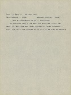
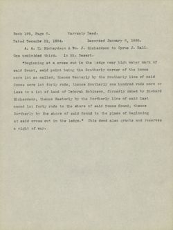
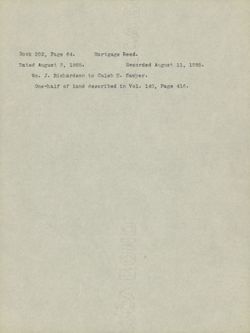
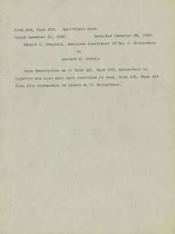
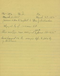
Book 197, Page 94.
Warranty Deed.
Dated December 1, 1884.
Recorded December 1, 1884.
Albert A. K.Richardson to Wm. J. Richardson.
One undivided half of the same land described in Vol. 140,
Page 416., with this additional reservation, "Also reserving all
other lots heretofore conveyed out of this lot as shown of record."
are 6368 3006
.4881
... 0.7 .A
(LeV of basi orice gill " O 1180 9.00
OHIAN aids dis 93.89
20 INC he rodin
you,
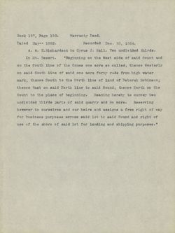
Book 197, Page 150.
Warranty Deed.
Dated May- 1882.
Recorded Dec. 30, 1884.
A. A. K.Richardson to Cyrus J. Hall. Two undivided thirds.
In Mt. Desert. "Beginning on the West side of said Sount and
on the South line of the Somes one acre so called; thence Westerly
on said South line of said one acre forty rods from high water
mark; thence South to the North line of land of Deborah Robinson;
thence East on said North line to said Sound; thence North on the
Sount to the place of beginning. Meaning hereby to convey two
undivided thirds parts of said quarry and no more. Reserving
however to ourselves and our heirs and assigns a free right of way
for business purposes across saidilot tc said Sound and right of
use of the shore of said lot for landing and shipping purposes."
.best
,00
S885
CW n carry 0.9
bas tarra state to obte 7897 oily 10 di
bonsta 08 5208 age 89008 to and to
NECEW abot STOP srife hase to saft bise no
the 5001 to shill 8/5 of
Brown 8.7 errors 700 dell
own of spainhingo to 55819 of st tastes
4,970.00 be bour biks 50.0 27760 abril.
C5, 20 T Date in angiest 700 bas payleesce

