
From collection Jesup Library JDR Jr. Collection

Page 1

Page 2
Page 3

Page 4
Page 5

Page 6
Page 7

Page 8
Page 9

Page 10
Page 11

Page 12
Page 13

Page 14
Page 15

Page 16
Page 17

Page 18
Page 19

Page 20
Page 21

Page 22
Page 23

Page 24
Page 25

Page 26
Page 27

Page 28
Page 29

Page 30
Page 31

Page 32
Page 33

Page 34
Page 35

Page 36
Page 37

Page 38
Page 39

Page 40
Search
results in pages
Austin & Jordan Lots
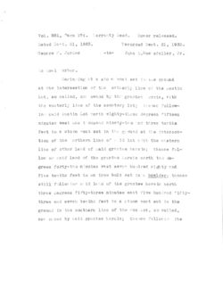
Vol. 581, Page 174. `arranty Deed. Dower released.
Dated Sent. 21, 1923.
Recorded Sept. 21, 1923.
George K. Jorden
-to
John ,Roelefeller, Jr.
in Seal arbor.
Beginning et a sto e post set in the ground
at the intersection of the ortherly line of the Austin
Lot, so called, no: owned by the grantee ercin, with
the westerly line of the cemetery lot; thence follow-
in said Austin Lot north eighty-three degrees fifteen
minutes west one t ousand ninety-tro nd three tenths
feet to a stone most set in the ground at the intersec-
tion of the orthern line of S 1d lot with the eastern
line of other land of said grantee herein; thence pol-
low no said land of the grantee herein north two de-
grees forty-two minutes vest seven hundred eighty and
five tenths feet to an iron bolt set in E bowlder; thence
still following s.id land of the grantee here in north
three degrees fifty-three minutes east five hundred "ifty-
three and seven tenths feet to a stone post set in the
ground in the southern line of the Fox Lot, so called,
nor ned by said grantee hercin; thence follovin the
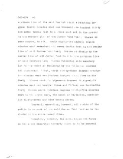
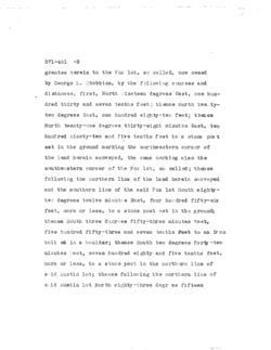
581-174 -2
s uthern line of the said Fox Lot south eighty-two de- -
grees twelve minutes east one thousand one hundred thirty
and seven tenths feet to a stone post set in the ground
in the western lin of the Jordan Pond Road ; thence on
same course, to vit: south eighty-two degrees trelve
minutes east seventeen and seven tenths feet to the center
line of said Jordan "and Road; thence southerly by the
center line of suff Jordan Pond Road to the northern line
or said Cemetery Lot; thence following said cemetery
lot to the point of beginning by the following courses
and distances: first, north eighty-three degrees twenty-
two minutes west one hundred forty-six and five tenths
feet; thence south Clirty-seven degrees thirty-eight
minutes west one hundred three and fifteen one hundredths
feet; thence south nineteen degrees thirty-five minutes
west to the stone post, the point of beginning, contain-
ing thirty-seven and nine tenths acres.
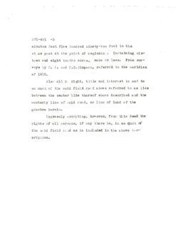
Expressly excenting, however, all rights of the
public in so much of the said Jorgan Pond Road as is in-
cluded in the above description.
Excepting however, the camp, ragon and forge
on the a ovo described property which is to be removed
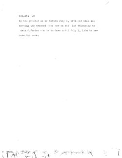
581-174 -3
by the grentor on or before July 1, 1924 and also ex-
centing the crushed rock now on sai lot belonging to
Ddwin C. Jordan who is to have until July 1, 1924 to r8-
move the same.
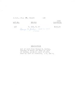
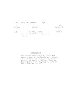
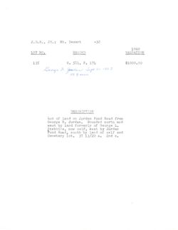
J.D.R., JR.; Mt. Desert
-30
1960
LOT NO.
RECORD
VALUATION
135
V. 502, P. 57
$120.00
George n Jordan - act 16,1913
3 acres
DESCRIPTION
Lot of land from George N. Jordan,
bounded on North and east by land
of Jordan, south by land of self,
west by land of Stebbins. 3 a. 1st C.
Vol. 503, Page 57.
Conditional warranty Dower released.
Dated Oct. 13, 1913.
Recorded Oot. 29, 1913.
George N. Jordan
-to-
John D.Rockefeller, Jr.
In Seal Harbor.
Boginning at a post in the ground at the northwest-
ern corner of the lot called the Austin Lot, formerly of
The Cooksey Realty Company no of the grantee herein, being
in the easterly line of the parcel know as the How tract,
formerly of George L. Stebbins, nor of thagrantee herein;
thence south eighty two degrees forty five minutes east,
but every here following the northerly line of 8 1 1 Austin
lot, no of the grantae herein, one hundred and six ty six
and four tenths feet to a stone bound; thene north
twenty two degrees fifteen minutes east eigity eight and
six tenths feet to an iron bolt; thence north twelve de-
grees fifteen minutes east one hundred and fifty five and
one tenth feet to an iron bolt; thence north four degrees
fifteen minutes west one hundred and ninety and four tenths
feet to an iron bolt; thence north nine degrees fifteen
minutes weat one hundred and twenty five and nine tenths
feet to an iron bolt; thence north thirty one degrees
502-57
-2
thirty minutes west to hundred and forty three and six
tenths feet to a stone bound; thence same course to the
centre OI the old road running from Long Pond meadows to
the Jordan Pond Road; thence southerly and southwesterly
but everywhere following the centre line of said old road
two hundred and ninety feet, more or less, to the extension
into the centre of said road of the northerly line of a
portion of saii How tract, no of the grentee herein; thence
south eighty degrees thirty four minutes east, passing
through a post, but everywhere following the line of the
said land of the grantee herein, sixty seven and seven
tenths feet to a post marking 8 corner in said land of the
grantse herein; thence south two degrees eight minutes west,
but everywhere following the easterly line of said land of
the grante herein four hundred and sixty five and two
tenths feet to the point of beginning, containing three
acres, more or less.
Also all my right, title and interest in and to so
much of the said old road above referred to as lies be-
tween the centre line thereof, above described, and the
westerly line of said road or line or land of the grantee
herein, SO far as s.id road adjoins the lot heroinabove de-
502-57
3
scribed as conveyed.
Expressly excepting, however, from this deod all
rights of the public in so much of the said old road as is
included in the above description.
NOTE:The following appears in the covenant clause:
(it being understood that the covenants in this dood in
no way cover or include the rights of the public in the
old road above referred to nor that portion of the west
erly half of said old road, included in the above de-
scription, the right, title and interest of the grantor in
which only is conveyed.)
And for the same consieraticn aforesaid, I, Carrie
E.Jordan wife of the said Goor! N. Jordan, and I, Hannah
A.Bracy, widow of the late George N. Jordan, deceased, be-
come parties to this deed for the purpose of releasing and we
hereby release and canvey to the grantee herein, and his
heirs and assigns, all our respective rights by descent,
rightsof dower and all other title in the premises hereinabove
described as conveyed.
J.D.R., JR. ; Mt. Desert
-31
1960
LOT NO.
RECORD
VALUATION
135
V. 571, P. 491
$260.00
George n Jordan Oct 10.1922
16.8 a,
DESCRIPTION
Lot of land from George N. Jordan the
westerly part of the Jordan Lot. Bound-
ed north by the Fox lot, east by land
formerly of George N. Jordan, south by
Austin lot now of self, west by land of
self. 16.8 a. 2nd C.
DOPI
adout
be
Crampol
hear
V.d
mitauA
.
.1192
Book 571, Page 491. Warranty Deed. Dower released.
Dated October 10th,1922.
Recorded Oct. 23, 1922.
George N. Jordan
-to-
John D. Rockefeller, Jr.
Seal Hardor in Mount Desert.
Beginning at a stone post set 1. the ground
in the northerly line of the lot called the Austin lot
at a corner of land of the grant ce herein; thence by
the eastern line of the land of the said grantee herein
to the old field road so called, leading from long Fond
Valley to Jordan pond by the following courses and dis-
tances, first, North twenty-two degrees forty-five min-
utes East, ninety-twc and one tenth feet; thence North
twelve degrees forty-five minutes East, one hundred
fifty-five and one tenth feet; thence North three de-
grees forty-five minutes est, one hundred ninety feet;
thence North eight degrees forty-five minutes West, om
hundred twenty-six feet; thence North thirty-one degrees
West two hundred forty-three and six-tenths feet to a
stone post in the center of the before mentioned old
field road; thence following the center line of said road
and continuing by the eastern line of land of the said
571-491 -2
grantee herein to the Fox lot, 80 called, now owned
by George L. Stebbins, by the following courses and
distances, first, North nineteen degrees East, one hun-
dred thirty and seven tenths feet; thence North two. ty-
two degrees East, one hundred eighty-two feet; thence
North twenty-one degrees thirty-eight minutes East, two
hundred ninety-two and five tenths feet to a stone pos t
set in the ground marking the northwestern corner of
the land herein conveyed, the same marking also the
southwentern corner of the Fox lot, so called; then ce
following the northern line of the land herein conveyed
and the southern line of the said Fox lot South eighty-
two degrees twelve minutes East. four hundred fifty-six
feet, more or less, to a stone post set in the ground;
thenoe South three degrees fifty-three minutes West,
five hundred fifty-three and seven tenths feet to an ir on
bolt set in a boulder; thence South two degrees forty -two
minutes West, seven hundred eighty and five tenths feet,
more or less, to a stone post in the northern line of
said Austin lot; thence following the northern line of
said Austin lot North eighty-three degr es fifteen
571-491 -3
minutos West five hundred ninety -two feet to the
stone post at the point of beginning . Containing six-
teen and eight tenths acros, more or less. From sur-
veys by C. E. and P. D. Simpson, referred to the meridian
of 1915.
Also all III right, title and interest in and to
so much of the said field rold above referred to 88 lies
between the center line thereof above described and the
westerly line of said road, or line of land of the
grantee herein.
Expressly excepting, however, from this deed the
rights of all persons, if any there be, in so duch of
the said field road as is included in the above des-
cription.
J.D.R., JR.; Mt. Desert
-32
1960
LOT NO.
RECORD
VALUATION
135
V. 581, P. 174
$1000.00
George n. Jondan Sept 21. 1923
37. acres
DESCRIPTION
Lot of land on Jordan Pond Road from
George N. Jordan. Bounded north and
west by land formerly of George L.
Stebbins, now self, east by Jordan
Pond Road, south by land of self and
Cemetery lot. 37 13/20 a. 2nd C.
J.D.R., JR.; Mt. Desert
-33
1960
LOT NO.
RECORD
VALUATION
136
V. 502, P. 76
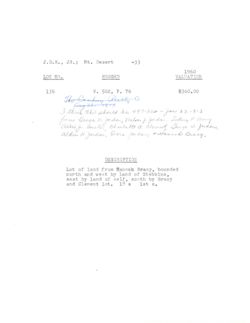
$360.00
The Cantasy Really Co
aug 28. 1913
I think this should be 497.362 - Jan 27, 1913
from George n. Jordan, meloan I Jordan Sietney P Bracy
alking austin, Charlette a clement George W. Jordan,
alden H Jordan, Dona Johdan, Hannah Bracy.
DESCRIPTION
Lot of land from Hannah Bracy, bounded
north and west by land of Stebbins,
east by land of self, south by Bracy
and Clement lot. 18 a 1st C.
CARE
the
J.D.R., , JR. ; Mt. Desert
-34
1960
LOT NO.
RECORD
VALUATION
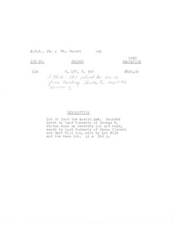
136
V. 497, P. 362
$820.00
I think this should be 502-76
from Cooley Realty Co, aug 28,1913
42 acres +
DESCRIPTION
Lot of land the Austin . Lot. Bounded
north by land formerly of George N.
Jordan east by Cemetery lot and road,
south by land formerly of James Clement
and Barr Hill lot, west by Lot #136
and the Howe lot. 41 a 2nd C.
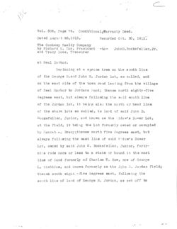
136
Vol. 502, Page 76. CondftionaleWarranty Deed.
Dated August 28,1913.
Recorded Oct. 30, 1913.
The Cooksey Realty Company
by Richard M. Hoe, President -to- TohnD.Rockefeller, Jr.
and Tracy Dows, Treasurer
at Seal Harbor.
Beginning at a spruce tree on the south line
of the George N.and John S. Jordan lot, so called, and
on the west side of the town road leading from the village
of Seal Harbor to Jordans Pond; thence north eighty-five
degrees weat, but always following the said south line
of the Jordan lot, it being also the north or head line
of the shore lots so called, to land of said John D.
Rockefeller, Junior, and known as the idow's Dower Lot,
at the field, it being the lot formerly owned or oc cupied
by Hannah s. Bracy;thence north five degrees east, but
always following the east line of said Widow's Dower
Lot, owned by said John D. Rockefeller, Junior, forty-
nine rods more or less to a stake or bound in the east
line of land formerly of Charles T. How, now of George
L. Stebbins, and known formerly as the John 3. Jordan field;
thence south eight - five degrees east, following the
south line of land of George N. Jordan, as set off to
502-76 -2
him by comnissioners appointed by the Probate Court,
to a birch tree at the aforesaid town road; thence
southerly following said town road forty-nine rods,
more or less, to the point of beginning, containing
forty-two acres, more or less.
It being the same lot described as conveyed
in the deed from Samuel J. Clement et als to George B.
Cooksey, dated August 10, 1895, and recorded in the
Hancock County Maine Registry of Deeds, Book 291,
Pace 409.
Expressly excepting however from the above
described tract and not hereby conveying the following
lots, viz:
The lot described as conveyed in the deed from
6 has
James Clement 2nd to Benjamin D. Perkins, dated July 26 5842
15
Clament
1887, and recorded in said Registry of Deeds, in Book
213, Page 509.
2- The lot described as conveyed in the deed
from James Clement 2nd to Pearl A. Conary, dated May
STE
3, 1880, and recorded in said Registry of Deeds in Book
S84E
281, Page 480.
3. The lot described as conveyed in the deed
N84W
8nd
from James Clement 2nd to Emily J. Pinkham, dated March
gross
And
next small meeting
502-76 -3
17, 1893, and recorded in said Registry in Book 283,
Page 348.
4- The lot described as conveyed in the deed
from George B. Cooksey to the Seal Harbor Cemetery
Association, dated November 13, 1896, and recorded in
said Registry in Book 307, Page 344.
See Abstract # 153A
, 36
BL
Vol. 497, Page 382.
Quit-claim Deed. Dower released.
Dated Jan. 27, 1913:
Recorded Apr. 30, 1913.
George N. Jordan,
Melvan J. Jordan
Sidney P. Bracy,
Abbie J. Austin,
Charlotte A.Clement
George 7.Jordan,
Alden II. Jordan,
Dora Jordan (the last
three being children and
only heirs of Alden H.
Jjrdan) and Hannah A.
Bracy (widos of George
N. Jordan)
-to- John D.Rockefeller,Jr.
In seal Herbor.
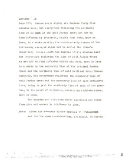
Beginning in the northern line of land of the grantee
herein, formerly known as the Herman Bracy lot, siid line
being the northerly line of the Bettlers Lots, so called,
at Seal Harbor and the southerly line of the SO called
Jordan tract, and at the southwesterly corner of the lot
formerly of George B.Cooksey know as the Abbie J. Austin
lot; thence generally northerly, but everythere following
the westerly line of said lot formerly known as the Abbie J. e
Austin lot to the southerly line of so much of the original
Jordan tract, so called, as W38 set off to John S.Jordan
by Commissioners appointed by the Probate Court of Hancook
County whose petition to amend the record in such partition
is recorded in Probate Records of Hancock County Vol. 62,
497-362 -2
Page 270; the nce north eighty six degrees forty five
minutes west, but everywhere following the southerly
line of 80 man of the said Jordan tract set off to
John S.Jordan as aforesaid, eighty four rods, more or
less, to a stake marking the northwesterly corner of the
lot hereby conveyed which lot is called the Widow's
Dower lot; thence south ten degrees thirty minutes west
but everywhere following the line of said Jordan Traet
as set 011 to John S.Jordan thirty six rods, more or less
to a stake in the southerly line of the original Jordan
tract and the northerly line of said Settlent lots; thence
easterly, but everywhere following the southerly line of
said Jordan tract and the northerly line of said Settler's
lots, being in part the northerly line of land of the gran-
tee, to the point of beginning, containing eighteen acres,
more or less.
The courses and distinces above mentioned are taken
from plan and survey by E.M.Hamor in 1882.
Note: After the covenant clause appears the followingi
And for the same consideration, aforesaid, we Carrie
497-362 -3
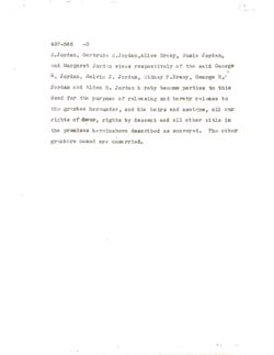
E.Jordan, Gertrude S.Jordan,Alice Bracy, Susie Jordan,
and Margaret Jordan wives respectively of the said George
N. Jordan, Helvin J. Jordan, Sidney P.Braoy, George W.
Jordan and Alden H. Jordan hereby become parties to this
deed for the purpose of releasing and hereby release to
the grantee herounder, and his heirs and assigns, all our
rights of dover, rights by descent and all other title in
the premises hereinabove described as conveyed. The other
grantors named are unmarried.

