
From collection Jesup Library JDR Jr. Collection

Page 1
Page 2
Page 3
Page 4
Page 5
Page 6
Page 7
Page 8
Page 9
Page 10
Search
results in pages
Wild Gardens Hayward Lot
No.
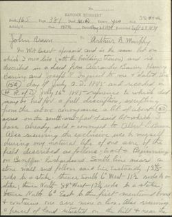
HANCOCK REGISTRY
Book 165
Page 381 Deed W A Dower yrs Sval
ssnta
Acknlg'd
Con.
1500, Datedang 211879 Recorded Seff-23/1779
John Brown
To
arthur A. murphy
In mt Desert afourard and is the same lot on
which I now live (with the buildings thereon) and is
described in a deed from alerander Baning Henry
Baring and Joseph R. Injersol to me t dated the
15th day if July a. D. 1845 and recorded in
H R. of D July 16" 1845 reference X which dud
may be had for a full discription, excepting
from the above country once a lot of about 50
acres on the south-wish-past of said lot-which I
have already sold t conveyed to Albert L.Brown.
also reserving the exclusive use to myself
during my natural life of one acre of the
field described as follows:, to witz Beginning
on Benf in' Richardsons South line near a
stone wall and follows said line Eastuardly 134/5
rods to a stake thence South 6 West 11 1/2 rods to
state; thence North 84 West-1334 ride to a state;
themer Nalty 60 East to the first mentioned found
of contains one acre more a has also reserving
a haved of land situated on the hill of near the
165-381 Ps 2
brink of the bank of a duf ranne said lot
being sit- rods square as now stated out by E,
M, Hamon said lot to be used for a burying
ground for myself and my hims provided however
if my heres shall or do not fince said lot within
ten years from this date shall be of no effect.
also I hereby convey as above to said Murphy one
other lot of 200 acres more a has which is discused
in aded from Greepth Startly to me dated March 28"
as 18674 recorded in H.R.N Oct 12"a. D. 1868
Book 131 Page 414,
No.
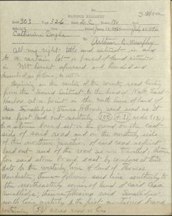
HANCOCK REGISTRY
s wita
Book 303 Page 326 Deed 2 d Dower No
Seal
Ackalg's
Con.
Catherine Dayle
Dated June It 1896 Recorded July 221896
To
arthur A musphy
all my night title and intent in and
to a certain lot or parcel of land situated
in mr Deat afriraid and founded and
described as follows, to wit
Beping in the center of the county road hading
from the Sound District to the head of Nath East
Harbor at a point in the north line of land of
asa Smalludge. : thence following said road as it
was first Paid out notherly 00 +31,
nods (131)
to a stone bound set-in the ground on the east
side of said road and on the northerly side
of the northern Junction of said road as first,
laid out and M the road as now havelled theme
from said stone found east by compass at this
date to the mesterly line of land of Thomas
Manchester ; them following said line southerly to
the northeasterly corner of land of said asa
Smallidge; theme following said Smallidjes'
north line mesterly to the first mentioned bound,
containing 50 acres more or less
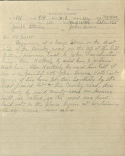
No.
HANCOCK REGISTRY
Book 131
Page 414 Deed W ()) Dower Ye Seal SS wta
Acknly's
Con. 100,
Dated March 28/86,7000 Oct121 1868
Joseph stanley
John Brown
To
In mt Desert
Beginning al a large Stone on the West
side of the Country road on the loh of the hill
thence running East to John Manchester
him then Nothers by said him to Joidana
West line then Northerly by said line till it
comes in haralled with John Browns North East
Comer of his home lot then Southuly by the
head of said lot to the County road, then
Southerly by said County road over Browns
Hill so called, as the road was first
laid out to the place begun at containing
2001 acris more orles
Eaculin
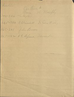
arthur, A
Clara Hi murphy
303-326 -C.Dayle,
225-390 EBlaisdell to Dis MA,
165-381 John Brown
145-102 R S. Lopaus, premont
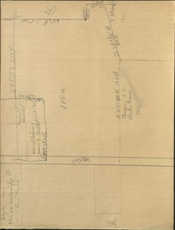
Dayle 1896
where was asa smallipse It
583°38'E 212R
" " Themes Marchate
Blaisdill
Harrey LiPerbins +
ard
James 7,
3 84°57R22L
$ 149
the
the
188a
WH THE
583'50'E
12R SL
11-12
Shu
N89030W 166R
S280R
7 mand
Benjam ct
1901
Charles hares
1901
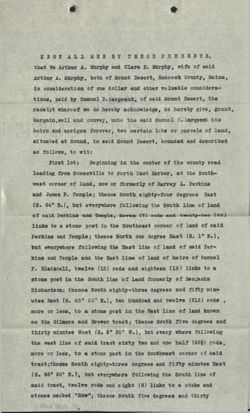
KNOW ALL MEN BY THESE PRESENTS,
that We Arthur A. Murphy and Clara H. Murphy, wife of said
Arthur A. Murphy, both of Mount Desert, Hancock County, Maine,
in consideration of one dollar and other valuable considera-
tions, paid by Samuel D. Sargeant, of said Mount Desert, the
receipt whereof we do hereby acknowledge, do hereby give, grant,
bargain,sell and convey, unto the said Samuel D. Sargeant his
heirs and assigns forever, two certain lots or parcels of land,
situated at Sound, in said Mount Desert, bounded and described
as follows, to wit:
First lot: Beginning in the center of the county road
leading from Somesville to North East Harbor, at the South-
west corner of land, now or formerly of Harvey L. Perkins
and James F. Temple; thence South eighty-four degrees East
(s. 84° E.), but everywhere following the South line of land
of said Perkins and Temple, Seven (7) rods and twenty-two (22)
links to a stone post in the Southeast corner of land of said
Perkins and Temple: thence North one degree East (N. 1° E.),
but everywhere following the East line of land of said Per-
kins and Temple and the East line of land of heirs of Samuel
P. Blaisdell, twelve (12) rods and eighteen (18) links to a
stone post in the South line of land formerly of Benjamin
Richardson; thence South eighty-three degrees and fifty min-
utes East (s. 83° 50' E.), two hundred and twelve (212) rods
more or less, to a stone post in the West line of land known
as the Gilmore and Brewer tract; thence South five degrees and
thirty minutes West (S. 5° 30' W.), but every where following
the west line of said tract sixty two and one half (621) rods,
more or less, to a stone post in the Southwest corner of said
tract;thence South eighty-three degrees and fifty minutes East
(S. 83° 50' E.), but everywhere following the South line of
said tract, twelve rods and eight (8) links to a stake and
stones marked "How"; thence South five degrees and thirty
(2)
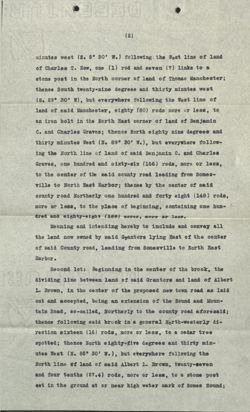
minutes west (S. 5° 30' W.) following the West line of land
of Charles T. How, one (1) rod and seven (7) links to a
stone post in the North corner of land of Thomas Manchester;
thence South twenty-nine degrees and thirty minutes west
(S. 29° 30' W), but everywhere following the West line of
land of said Manchester, eighty (80) rods more or less, to
an iron bolt in the North East corner of land of Benjamin
C. and Charles Graves; thence North eighty nine degrees and
thirty minutes West (N. 89° 30' W.), but everywhere follow-
ing the North line of land of said Benjamin C. and Charles
Graves, one hundred and sixty-six (166) rods, more or less,
to the center of the said county road leading from Somes-
ville to North East Harbor; the nce by the center of said
county road Northerly one hundred and forty eight (148) rods,
more or less, to the place of beginning, containing one hun-
dred and eighty-eight (188) acres, more or less.
Meaning and intending hereby to include and convey all
the land now owned by said Grantors lying East of the center
of said County road, leading from Somesville to North East
Harbor.
Second lot: Beginning in the center of the brook, the
dividing line between land of said Grantors and land of Albert
L. Brown, in the center of the proposed new town road as laid
out and accepted, being an extension of the Sound and Moun-
tain Road, so-called, Northerly to the county road aforesaid;
thence following said brook in a general North-westerly di-
rection sixteen (16) rods, more or less, to a cedar tree
spotted; thence North eighty-five degrees and thirty min-
utes West (N. 85° 30' W.), but everywhere following the
North line of land of said Albert L. Brown, twenty-seven
and four tenths (27.4) rods, more or less, to a stone post
set in the ground at or near high water mark of Somes Sound;
(3)
thence on same course to low water mark of said Sound;thence
by low water mark in its various turnings a and windings,
but generally northerly, to a point bearing North eighty-
five degrees and thirty minutes West (N. 85° 30' W.) from
a stone post set in the ground on the bank of said Sound;
said last mentioned stone post being about one and one-half
(11) rods from high water mark of said Sound and ten (10)
rods Northerly measuring at right angles from the South
line of said herein described lot; thence South eighty-five
degrees and thirty minutes East (S. 85° 30' E.), to said
stone post on the bank of said Sound; thence South eighty-
five degrees and thirty minutes East (S. 85° 30' E.), thirty
rods, more or less, to a stone post set in the ground; thence
South fifty-six degrees East (S. 56° E.) fifteen and six tenths
(15.6) rods, more or less, to a stone post at or near the West
side of said proposed new town road; thence on same course to
the center of said proposed new road, thence following the
center of said proposed new town road Southerly ten and one
tenth (10.1) rods, more or less, to the place of beginning,
containing two and seventy-four hundredths (2.74) acres, more
or less.
Together also as appurtenant to every part of both lots
herein above described, a free open and unobstructed right
of way, for all purposes of a way, two rods wide from the
Eastern side of the lot last above described to the Western
side of the lot first above described
Said way to follow the road as now constructed and travel-
led from said proposed new town road to said county road.
Said way to be used in common by the said Grantee, his heirs
and assigns, and the said Arthur A. Murphy, his heirs and as-
signs.
Together also with a right to lay and maintain water,
sewer and drain pipes from the lot first herein above de-
scribed, to the lot last hereinabove de-
(4).
scribed, under the surface of the above described way, through-
out the entire length of the same.
TO HAVE AND TO HOLD the aforegranted and bargained prem-
ises, with all the privileges and appurtenances thereof,to
the said Samuel D. Sargeant, his heirs and assigns, to his
and their use and behoof forever.
And we do COVENANT with the said Grantee, his heirs and
assigns, that we are lawfully seized in fee of the premises;
that they are free of all incumbrances; that we have good
right to sell and convey the same to the said Grantee to hold
as aforesaid; and that we and our heirs shall and will war-
rant and defend the same to the said Samuel D. Sargeant, his
heirs and assigns forever, against the lawful claims and de-
mands of all persons.
IN WITNESS WHEREOF, we the said Arthur A. Murphy and
Clara H. Murphy have hereunto set our hands and seals this
fourteenth day of October, in the year of our Lord one thou-
sand nine hundred and one.
Signed, Sealed and Delivered
in presence of
J. H. Knowles
Arthur A. Murphy
(L.S.)
as to both
Clara H. Murphy
(L.S.)
STATE OF MAIN E.
XCounty of Hancock SS.:
October 24, 1901.
Personally appeared the above named Arthur A. Murphy and
Clara H. Murphy and acknowledged the above instrument to be
their free act and deed.
Before me,
Jerome H. knowles,
Notarial.
Notary Public
Rec'
Rec'd Oct. 26, 1901, at 3h. P.M. and entered
in Vol. 369 Page 189, by
W. B. Campbell Reg'r.
A true copy:
ATTEST:
Register of
Deeds.
Viewer Controls
Toggle Page Navigator
P
Toggle Hotspots
H
Toggle Readerview
V
Toggle Search Bar
S
Toggle Viewer Info
I
Toggle Metadata
M
Zoom-In
+
Zoom-Out
-
Re-Center Document
Previous Page
←
Next Page
→
Wild Gardens Hayward Lot
Hand written descriptions of lots in Mt. Desert

