
From collection Creating Acadia National Park: The George B. Dorr Research Archive of Ronald H. Epp

Page 1
Page 2
Page 3
Page 4
Page 5
Page 6
Page 7
Page 8
Page 9
Page 10
Page 11
Page 12
Page 13
Page 14
Page 15
Page 16
Page 17
Page 18
Page 19
Page 20
Page 21
Page 22
Page 23
Page 24
Page 25
Page 26
Page 27
Page 28
Page 29
Page 30
Page 31
Search
results in pages
Chapman Archive Map Index 1984
Chapman archive:
Maptudex (1984)
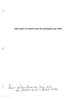
1984 INDEX TO MAPS FILED IN CHAPMAN LAW FIRM
Serence Wilhom Horner, M.D. July, 2011.
see 7/28/2011 email in Archive Folder.
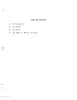
TABLE OF CONTENTS
1.
Instructions
2. Breakdown
3. Map List
4. Map List II (Metal cabinet)
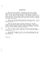
INSTRUCTIONS
Each slot has a number. The maps in each slot may not
pertain to the same area, etc. There may be one for Acadia
National Park, one for Mount Desert Island and one for Hulls
Cove. It was done this way because of the number of maps to be
taken care of and the lack of space. The same map may also be in
three different slots because the map room was in such a disaray.
There were just too many maps and trying to put them all together
was nearly impossible.
There is a box of unidentified maps under the table. If you
use one and can identify it, please let it be known so it can be
put on the list.
There is another map list which contains all the maps
located in the metal cabinet underneath the table. There is a
drawer labeled Rockefeller maps. Most of Rockefeller's maps are
in that drawer, however, some are scattered throughout the main
map list so you should look in both places.
There is also a large cloth roll which has numerous maps
pasted to it. This will be indexed at a later date and added to
the main map list.
Going down through the list is one way of finding what you
are looking for. A faster way is to use the FIND button on the
word processor.
Thank you!
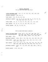
PARTIAL BREAKDOWN
(To be used with main map list)
ACADIA NATIONAL PARK - #12, 17, 22, 233, 237, 246, 248, 249
BRUNNOW PROPERTY - #21, 40, 52
DUCK BROOK - #15, 23, 30, 96, 210,
NORTHEAST HARBOR - #9, 47, 49, 55, 67, 68, 71, 77, 90, 91, 92,
102, 202, 205, 207, 211, 235
OTTER CREEK - #4, 44, 77, 94, 97, 201, 202, 211, 213, 218
SEAL HARBOR - #4, 25, 51, 53, 54, 204, 205, 214, 217,
WINTER HARBOR - #8, 66, 72, 86, 217
(To be used with metal cabinet)
ACADIA NATIONAL PARK - #155, 161.1, 172, 206, 208, 209, 212,
213, 507, 513, 520.1, 531, 545, 558, 560,
406, 407, 408.1, 408.2, 412, 432, 436
DUCK BROOK - #521
NORTHEAST HARBOR - #180, 180.1, 216, 509, 561, 563, 604, 607, 613
OTTER CREEK - #185, 215, 505, 512.41, 514, 558, 413, 413.1, 429
430, 430.1, 434, 702
SEAL HARBOR - #115, 177, 177.1, 181, 182, 183, 190, 192, 194, 198
200, 201, 536, 538, 551, 555, 562, 701, 702, 714
SOUTHWEST HARBOR - #168, 711, 713, 801, 802, 805, 806.1, 806.11,
807
WINTER HARBOR - #159, 162, 602
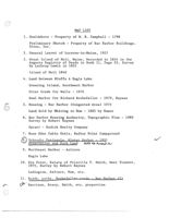
MAP LIST
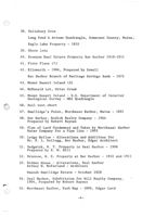
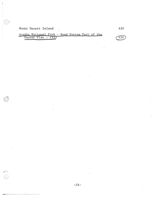
1. Gouldsboro - Property of W. B. Campbell - 1798
Preliminary Sketch - Property of Bar Harbor Buildings.
Sites, Inc.
2. General Layout of Lucerne-in-Maine, 1927
3. Great Island of Holt, Maine, Recorded in 1824 in the
Augusta Registry of Deeds in Book 11, Page 53, Survey
by Lathrop Lewis in 1803
Island of Holt 1840
4. Land Between Bluffs & Eagle Lake
Greening Island, Southwest Harbor
Otter Creek for Walls - 1976
Seal Harbor for Richard Rockefeller - 1979, Raynes
5. Housing - Bar Harbor (Congested Area) 1975
Land Sold by Whiting to How - 1885 by Hamor
6. Bar Harbor Housing Authority, Topographic Plan - 1980
Survey by Robert Raynes
Spratt - Rodick Realty Company
7. Rose Eden Cabin Units, Hadley Point Campground
8.
Schoodic Peninsula. Winter Harbor - 1931
Reservation and Park Land Add to Acadia
9. Northeast Harbor - Asticou
Eagle Lake
10. Dix Point, Estate of Priscilla T. Smith, West Tremont,
1975, Survey by Robert Raynes
Ludington, Salters, How, etc.
11. Roads, paths, Rockefeller roads - Bar Harbor (?)
Harrison, Bracy, Smith, etc. properties
12
Milliken, McLaughlin, Robbins, Peterson on
Eagle Lake Road
Acadia National Park, Proposed park roads, North end
of Tarn - 1930
Town of Bar Harbor, Isolated Hospital Lot
13. Blueberry Hill Development, Bar Harbor, August 1980
Survey by Robert Raynes
14. Wharf, Randolph, Prospect Avenue, Bar Harbor
Survey by J.E. Savage
Lucerne-in-Maine - November 15, 1928
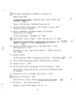
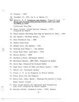
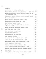
5
Duck Brook, Town of Eden - 1890, Survey by E. M. Hamor
Property of John Markoe, George Dorr and Others, Bar CBP
Harbor - 1906
16. Lucerne-in-Maine, Section F, Phillips Lake - 1926
and Section I - 1927
Salisbury to How, Town of Bar Harbor - 1890, Survey by
E.M. Hamor
17. Manset, Maine
Acadia National Park, Proposed boundaries - September 1968
18. Long Island Plantation 1968 & 1969 by Robert Raynes
19. Henderson Lot - 1922
20. Brook End Property Landscape Plan Alterations - 1899
Shore Drive along and across streets of Crabtrees Field,
by Simpson
21. Property of R. E. Brunnow, Bar Harbor - 1916
22
Henderson Property - 1921
Mount Desert Island, Showing Acadia National Park - 1927
23. Henderson - Duck Brook Section
Higgins, Around Duck Brook, Lot No. 32
-2-
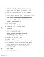
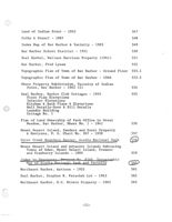
24. Sonogee Plan, Mary E. Haight Estate, Bar Harbor
1907, Survey by Edgar I. Lord
Town of Palm Beach, Zoning Map (3 Pages) - 1969
25. Wharf lot, Seal Harbor, July 15, 1910, Simpson
26. Kennedy
27
Hatstat, David, Stueben, Maine - Northern Half - 1979
Mount Desert Island Transit Company - Maine Shore
28. Thundermist Road, Final Plan of Subdivision, Town of
Bar Harbor - 1977
Town Hill, Edward Samuel Lot
29. Dix Point, Tremont
Mineral Map of Nova Scotia
30. Duck Brook, Eden - July 1890, Hamon
Duck Brook
31. Bowler to Lyons (Road Between)
Mount Desert Island - 1906
Sampson Property subdivision, Bar Harbor
Building Sites, Inc. - 1948
Land between Eagle Lake and Bluffs
32. Tunk Pond and Vacinity - 1901
33. Tremont - 1897
34. Blueprint possibly of Main and Cottage Streets (?)
35. Bar Harbor real estate and building - 1895, Mears
Lots of Hagerth, Lally, Hadley, Walls, Bunker,
White, Emery, etc. - late 1800's, early 1900's
36. Bar Harbor - 1896
Swans Island
37. Mount Desert Island (3)
-3-
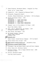
38. Salisbury Cove
Long Pond & Attean Quadrangle, Somerset County, Maine,
Eagle Lake Property - 1910
39. Shore lots
40. Brunnow Real Estate Property Bar Harbor 1910-1911
41. Floor Plans (?)
42. Ellsworth - 1966, Prepared by Sewall
Bar Harbor Branch of Heritage Savings Bank - 1975
43. Mount Desert Island (3)
44. McDonald Lot, Otter Creek
45. Mount Desert Island - U.S. Department of Interior
Geological Survey - MDI Quadrangle
46. Soil test chart
47. Smallidge's Point, Northeast Harbor, Maine - 1891
48. Bar Harbor, Rodick Realty Company - 1964
Prepared by Robert Raynes
49. Plan of Land Condemned and Taken by Northeast Harbor
Water Company for a Pipe Line - 1905
50. Ledge Hollow - Alterations and Additions for
Mr. F. L. Kellogg, Bar Harbor, Edgar Architect
51. Sedgwick, W. T. Property in Seal Harbor - 1906
Prepared by E. W. Hill
52. Brunnow, R. E. Property at Bar Harbor - 1910 and 1911
53. Hidden House - Alterations, Seal Harbor
Arthur W. McFarland - Architect
Hannah Smallidge Estate - October 1928
54. Seal Harbor, Subdivision for Hill Realty Company,
1964, Prepared by Robert Raynes
55. Northeast Harbor, Path Map - 1899, Edgar Lord
-4-
55. Tremont - 1954
56. December 14, 1974, by C. A. Meuth (?)
57
Roberts, W. M. Property Bar Harbor, Prepared from
Notes and Surveys made During August 1895 and 1899
by Edgar I. Lord
Cleftstone Area Map
58. Swans Island, Island Retreat Company - 1973
Prepared by Sewell
59. Mount Desert Building Zone Map by Maurice H. Burr - 1955
60. Bar Harbor, 109 Main Street - 1973
61. East Penobscot Bay - 1882
62. Bubble Pond Road
63. Newman Lots, Bar Harbor - 1921
64. Parking Area Phase 1 - Bar Harbor
65. Break Neck Road, Land East - 1910
66. Winter Harbor = 1898
67. Gardner's Point, Northeast Harbor
68. Northeast Harbor, 1881-1894, Prepared by Homer
69. Soils Map, Prepared by Richard Babmi
70. High Head, Towns of Eden and Mount Desert - 1888
71. Abbott Lot, Northeast Harbor
72. Tracy, G. W. et al Property in Winter Harbor
73. Fifty Units for the Elderly
74. Hulls Cove, Eden, Maine - Showing Old Seller's Lines
Mount Desert Island
75. Plan of Bar Harbor for National Park Foundation
Year 1979, Prepared by Robert Raynes
76. Suttons Island, Cranberry Isles - 1969, Raynes
-5-
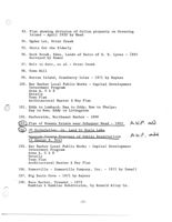
77. Emery Property, Northeast Harbor - Original Lot Plan
Bracy, et al - Otter Creek
78. Somesville - 1971, Prepared by Sherwood Tuell
79. Ellsworth, Prepared by Sewell
Herndon, Edward Subdivision, Bar Harbor - 1971 by Raynes
80. Marine Vocational Center - 1976
Site Plan
Building No. 1 - Lower Level Plan
Building No. 1 - Upper Level Plan
Building No. 1 - Elevations
Building No. 2 - Floor Plan & Elevations
Building No. 3 - Floor Plan & Elevations
81. Tremont, Lots A & B on Dodey's (?) Point - 1909
Map of Bar Harbor, Maine
82. Baer, John S. Subdivision, Bar Harbor - 1977
Surveyed by Edward B. Jackson
83. Main Street, Bar Harbor - 1977
84. Bar Harbor Airport, Trenton
Layout Plan & Profile
Property Plan
85 Schoodic Area
Swans Island, Island Retreat Company - 1971 by Sewall
86. Winter Harbor Plan of Land - 1954
87. Mount Desert Island Transit Co. - Automobile Road
8
Mountains on Mount Desert Island
89. Frenchman's Bay and Mount Desert Land and Water Company
90. School House Lot, Northeast Harbor
91. Northeast Harbor - West of Upper Hadlock Pond - 1889
Surveyed by Hamor
92. Asticou, Northeast Harbor
Line Rail Road Location
-6-
93. Plan showing division of Colton property on Greening
Island - April 1932 by Reed
94. Ogden Lot, Otter Creek
95. Units for the Elderly
96. Duck Brook, Eden, Lands of Heirs of S. E. Lyons - 1893
Surveyed by Hamor
97. Holt to Gott, et al - Otter Creek
98. Town Hill
99. Sutton Island, Cranberry Isles - 1971 by Raynes
100. Bar Harbor Local Public Works - Capital Development
Investment Program
Area A, C & E
Details
Town Plan
Architectural Master & Key Plan
101. Eddy to Lombard; Day to Eddy; How to Phelps;
Day to How; Eddy to Livingston
102. Harborside, Northeast Harbor - 1890
103 Plan of Homans Estate near Schooner Head - 1903
A.N.P. add
104
JD Rockefeller Jr. Land by Eagle Lake
Hancock County Trustees of Public Reservations
AN.P. add
to George B. Dorr
105. Bar Harbor Local Public Works - Capital Development
Investment Program
Area A, C & E
Details
Town Plan
Architectural Master & Key Plan
106. Somesville - Somesville Company, Inc. - 1971 by Sewall
107. Big Basin Cove - 1971 by Raynes
108. Bass Harbor, Tremont - 1973
Hamblen & Hamblen Subdivision, by Ronald Alley Co.
-7-
201
Indian Point
Pinchot Lot, Eden Street Bar Harbor - 1903,
Salem Town Plan
Thirlstane owned by Hamilton - 1937
Fish House Lots - Otter Creek
Plan showing easements of Bar Harbor Sewer
Rehabilitation Program, Eden Street to Eagle
Lake Road - October 1979, Raynes
202. Otter Creek, Smith-Dolliver
202. Mount Desert Transit Co - Ellsworth
Survey by C.P. Simpson
Mable S. Ingalls Property, Northeast Harbor - 1966, Raynes
Trescott - 1967
Map and property titles for Chesley R. Cole - 1967
Lots near Turtle Lake
203. Eden, Town Lines and Bounds - 1812
Survey by James Peters - Book 3, Page 62
Road Sections - corrected July 1926
Davis, et al - near cemetary
204. Ellsworth - Main Street to Cords Brook
Minor Civil Divisions, prepared by State Highway
Commission Planning Division - 1962
Seal Harbor, key map - 1955
205. Bar Harbor (Bottom half of map only) - 1895
Upper Hadlock Pond, Tennis Club, Golf Grounds,
Steamboat Wharf
West Lubec Quadrangle
Indian Point, Eden, Maine - 1911 by Edgar I. Lord
Northeast Harbor, Sketch map for The Knowles Company
-8-
205. JD Rockefeller, Jr. - Seal Harbor - 1961
206. Southwest Harbor Water Company
Lyon Estate - Town Road
Mount Desert Island
207. Jordan Pond Road, Proposed Underpass - 1929
Northeast Harbor
Calais to West Quoddy Head
208. Bluffs - 1886
Bay Drive - Hulls Cove
209. New Mill Meadow, Sketch of Land Flowed by Beavers
Bar Harbor - 1921
Bar Harbor - Water Company Reservoir to Point on
County Road near Top of Salisbury Hill
Aerial view of Bar Harbor
210. Duck Brook Valley, Eden - Land of Rodick Realty Company
Surveyed by Lord - 1924
Duck Brook
Ladd, Walter G. - Change of Road Boundary Adjoining Property
Bar Harbor - 1912
Long Island Plantation - 1968, Raynes and 1969
211. Gorge Near Otter Creek
Kimball, Northeast Harbor
212
Mount Desert Island - Eastern Portion - 1881
Mount Desert Island Nurseries - 1898, Lord
213. Otter Creek - Land Bordering Creek
Otter Creek
Otter Creek from Mountain House Lot, Green Mountain
to Lothrop Lot
-9-
213. Prescott, J. H. at Otter Creek - 1899
214. Round Turn, Seal Harbor, JDR, Jr. - 1932
Dunbar Lots - Seal Harbor
Seal Harbor Realty Company to John D. Rockefeller, Jr.
215. Harden Lot, Mount Desert Island - 1899 by Lord
215. Savage Wood Lot - East of Hadlock Pond
Island of Holt
sx
Sketch of property lines (?)
216. Blue Hill Bay
217. Seal Harbor Water Company
Winter Harbor Land Association Property
218. Harrison - Otter Creek
219
Reef Point (for Mrs Beatrix Farrand) 1948
First Floor Plan
Second Floor Plan
Ground Floor Plan Before Alterations - 1947
220. Sorrento, Maine, Divisions 1-5, 1910
Tremont
221. Eagle Lake, Bar Harbor - 1910
222. Roads and property lots from Frenchman's Bay to Eagle Lake
223. Property lots beside Seal Cove Pond
Rockefeller road in Mount Desert
224. Island when called Eden
225. Preliminary - Section 1, Key Plan
226. Penobscot Bay - 1880
227. Martin Roberts/Hospital property, Bar Harbor
228. Map of Nova Scotia
-10-
229. Hulls Cove - Showing Old Settlor's Lines
230. Corksey Estate - Sea Cliff Drive
231. Mount Desert Island - 1935
232. West side of Island - lot lines
233
Acadia National Park Trails. roads and developed
areas - Eastern half of Island
234. Sargeant Point - Abbott Property, MDI - 1955
235. Original lot of Ansel L. Manchester, Northeast Harbor
- May 1922, Reed
236. Town of Bar Harbor Topographic Plan, July 1981, Raynes
Acadia National Park - 1956
238. West side of Sound - 1920, Clark
239. Property of Smith to Fenton, Bar Harbor
240. Town of Bar Harbor Public Work Capital Development and
Investment Program - Prints
241. Malvern Belmont Estates - Addition - blueprints
242. Bar Harbor Housing for the Elderly
243. "Faraway" - Fifty apartments for the Elderly, Bar Harbor,
Blueprints - 1980
244
Part of Bar Harbor, Town of Eden (47 maps)
Hulls Cove District, Town of Eden (5 maps)
Salisbury Cove District, Town of Eden (5 maps)
245. East and West side of Island with proposed roads
246
Acadia National Park - proposed motor roads Bar Harbor
247. Coves, Lakes, Bays, etc. - Island and surrounding areas
248
Acadia National Park and Vacinity - 1956
249
Acadia National Park Trails, roads and developed areas for
western half of Island
-11- -
MAP LIST II
(Metal Cabinet)
Drawer No. 1
Northern Maine
101
East Penobscot Bay - 1916
102.1
Eastern Penobscot Bay - 1939
102
Penobscot Bay & Approaches
103
Nova Scotia
104
State of Maine (Geological Survey)
105
Cape Sable to Cape Hatteras
106
Cross Island to Nash Island
107
O
Moose Cove to Englishman Bay (Including Machias Bay)
108
Mohegan Island to Cape Elizabeth
110
Nash Island to Schoodic Island
111
1922 Index to Small Maps of Parts of State
112
Dover, New Hampshire-Maine
112-1A
Berwick
112-1B
Newfield
112-10
Kezar Falls
112-1D
Fryeburg
112-1E
Bethel
112-1F
York, Maine-New Hampshire
112-2A
Kennebunk
112-2B
Buxton
112-2C
Sebago
112-2D
112-2E
Norway
Bryant Pond
1911
112-2F
Biddeford
1889
112-3B
Portland
1914
112-3C
1892
112-3D
Gray
Poland
1906
112-3E
Buckfield
1910
112-3F
Casco Bay
1914
112-4C
1890
112-4D
Freeport
1905
112-4E
Lewiston
Livermore
1910
112-4F
Farmington
1920
112-4G
Small Point
1890
112-50
112-5D
Bath
1890
Gardiner
1890
112-5E
Augusta
1890
112-5F
Norridgewock
1891
112-5G
1902
112-5H
Anson
Bingham
1903
112-5I
The Forks
1903
112-5J
Brassua Lake
1921
112-5K
1891
112-6D
Boothby
1891
112-6E
Wiscasset
Vasselboro
1891
112-6F
Waterville
1890
112-6G
Skowhegan
1912
112-6H
-2-
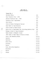
Moosehead Lake 1920
112-6K
Monhegan
1904
112-7D
Waldoboro
1913
112-7E
Liberty
1914
112-7F
Rockland
1914
112-8E
Belfast
1914
112-8F
Vinalhaven
1901
112-9E
Castine
1900
112-9F
Deer Isle Quadrangle
112-10E
Bluehill Quadrangle
112-10F
Orland
1899
112-10G
Passadumkeag
1915
112-101
Ellsworth Qudrangle
112-11G
Winn Quadrangle
1916
112-11J
Bar Harbor Quadrangle
112-12F
Petit Manan Quadrangle
1901
112-13F
Cherryfield Quadrangle
1901
112-13G
Gorham, New Hampshire - Maine
112-XF
Oak Point, Trenton
113
Jordan Pond Road
114
Seal Harbor - Coakrey Property (1913) (3)
115
Shore Club
116
Bench Mark Elevations of Black Woods
117
Bar Harbor, Main Street - Rodick Street
118
Hancock County Highway & Topography (Southeast) 1938
152
Hancock County Highway & Topography (North) 1938
153
-3-
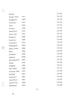
Hancock County Highway & Topography (Southwest) 1938
154
Acadia National Park - Topography - 1931
155
Blue Hill Bay & Western Mount Desert Island - 1906
156
Blue Hill Bay & Eggemoggin Reach - 1909
157
Winter Harbor Property
159
Mount Desert Island - 1934
161
General Development Property. Part of Plan of
Acadia National Park - 1957
161.1
Bar Harbor Quadrangle - 1902
161.2
Winter Harbor - 1905
162
Grindstone Neck
163
Thirlstone Ranch, Inc., , Testing Map on Sketch
164
Frenchman Bay & Eastern Parts - 1940
166
Frenchman Bay & Eastern Parts - 1950
166.1
Ironbound Island
167
Bar Harbor - 1956 (Colored)
169
Bar Harbor - 1956 (Uncolored)
170
Surry, by Kenniston - 1958
171
Acadia National Park, Block 42,43,50,54, Parcel 62
172
Plan of Town Improvement Area - Stoningham - 1963
173
Ellsworth Zoning Map - 1955
174
Franklin
175
Ellsworth, County Road, Plan of Right of Way
176
Mount Desert Island Road Map - 1934
202.1
Bar Harbor
203
Mount Desert Island - 1911
204
-4-
Acadia National Park, The Road System, - 1935
206
General Highway Map of Hancock County - 1938
207
Acadia National Park and Vacinity - 1935
208
Acadia National Park and Vacinity - 1935 (6)
209
Acadia National Park Extension
212
Acadia National Park and Vacinity - 1942
213
Mount Desert Island (7)
214
Otter Creek
215
Lafayette National Park - 1901 (2)
17
Lafayette National Park - 1928
217.1
Mount Desert Island - 1935
220
Island Property Map 1935
221
-5.-
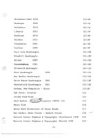
Drawer 2
ROCKEFELLER MAPS
Bar Harbor (1960) JDR, Jr.
147
Bar Harbor, Land of JDR, Jr. 2 USA, Dorr &
IBD
Wild Gardens
148
Mount Desert Island (1960) JDR, Jr.
149
Bar Harbor (1958) JDR, Jr. (Lots Nos. 330, 331, 332)
150
Mount Desert Island (1955) JDR, Jr.
151
Mount Desert Island (1959) JDR, Jr. (Lots Nos.
342, 343, 344)
158
Bar Harbor (1960) JDR, Jr. (Lots Nos. 317, 327,
328, 329)
160
Long Pond, Southwest Harbor (1958) JDR, Jr.
(Lots Nos. 261, 262, 262-1, 262-A-1)
168
Seal Harbor Property (1961) (2)
177
Seal Harbor Property (1960) (4)
177.1
Mount Desert Island (1960) JDR, Jr.
178
Bar Harbor (1959) JDR, Jr.
(Lots Nos. 323, 333, 325, 326)
179
Northeast Harbor (1954) (3) JDR, Jr.
180
Northeast Harbor (1954) JDR, Jr. (Lots Nos. 214,
292, 292-2, 292-3, 292-1-X, 292-2-X, 292-3-X
308, 312, 313, 318)
180.1
Seal Harbor (1959) - Nelson A. Rockefeller
from Drummond
181
Seal Harbor (1958) (2) JDR, Jr., Nelson & David
182
Seal Harbor (1961) (3) Estate of JDR, Jr.
183
Bar Harbor, Lower Ledgelawn Avenue Extension (1953)
184
Otter Creek (1956) JDR, Jr. & USA
(Lots Nos. 97, 98-1, 98-2)
185
-6-
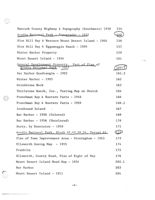
Drawer 4
Lots Between Park Office and Great Meadow - 1945
401
Long Pond Lots - 1956
402
Mount Desert Island, Building Zoning Map - 1955
403
Bar Harbor, Eden Apartments (5) - 1980-1981
404
Belmont Estates, Bar Harbor (Addition) - 1436 (6)
Planting Schedule
405
Acadia National Park - 1941
406
JDR Outline Map West Part of Island
406.1
Park Office to Great Meadow
406.2
Mount Desert Island Property Map - 1935
(Same as at Rodick's Office)
406.4
Acadia National Park & Vacinity - 1935
407
Proposed Boundary Line of Acadia National Park
from Hunters Beach Head
408.1
Proposed Boundary Line of Acadia National Park
from Hunters Beach Head
408.2
McFarland's Subdivision Line - 1937
409
Western Part of the Island to Somes Sound
410
Western Part of the Island to Somes Sound
410.1
Mount Desert Island
411
Proposed Entrance to Acadia National Park from
Bar Harbor, via Ledgelawn Avenue Extension - 1954
412
Kebo Valley Club
412.1
Proposed Alignment-Park Headquarters
412.2
Between Otter Creek and Ocean Drive
413
Otter Creek, Both Sides
413.1
Proposed Park Motor Road
4.14
-12-
Approximate Location of Proposed Property Line
Near Hunter's Cove
415
Approximate Location of Proposed Property Line
Near Hunter's Cove
415.1
Seal Harbor Realty Company, Transferred to JDR 1-36
416.1
Seal Harbor Realty Company, Transferred to JDR 2-36
(Track #3)
418
Seal Harbor Realty Company, Transferred to JDR
(Track #4)
419
Seal Harbor Realty Company, Transferred to JDR
(Track #5)
420
Seal Harbor Realty Company, Transferred to JDR
(Track #6)
421
Seal Harbor Realty Company, Transferred to JDR
(Track #7)
422
Seal Harbor Realty Company, Transferred to JDR
(Track #8)
423
Seal Harbor Realty Company, Transferred to JDR
(Track #9)
424
Plan Showing Sewer Rights and Building Restrictions
on Properties Formerly of Seal Harbor Realty Co.
425
Map Sieur de Monts National Monument - 1916
426
Mount Desert Island - 1935
427
Great Meadow Hill Area. Acadia National Park and
Adjoining Property 11-48 -
428
Otter Creek
429
Wellington-Lothrup - Otter Creek
430
Otter Creek, Tracing of Lots West
430,1
Somes Sound to Seal Cove Pond
431
Acadia National Park - Trail System 1939
432
Mount Desert Island
433
West of Otter Creek from Kelly Lot to Bubble Pond
434
-13-
Mount Desert Island
435
Acadia National Park - Road System Part of the
Master Plan - 1935
436
-14-
Drawer 5
Area A Site and Utilities Plan (5)
601
Winter Harbor, Arcadia Acres, Sheet No. 1 - 1961 (11) 602
Mount Desert Island, Section of State Highway No. 3
by Kenniston, 1948
603
Lippencott, Walter (Estate) - 1964, Northeast Harbor
604
Pretty Marsh 1948
605
Widner Property, Northeast Harbor - 1946
607
Mount Desert Island Zoning Map - 1939
608
Town of Mount Desert - 1939
609
Curtis, Joseph, Town of Mount Desert, Asticou
Terraces - 1935
612
Savage and Butler, Northeast Harbor - 1945
613
Long Pond, West Side - 1956
614
Seal Harbor, by George Simpson
701
Otter Creek/Seal Harbor
702
Sea Cliff Drive and Land North
703
Boyd Road and Vicinity
705
Lewis, Col. C. H. near Turtle Lake - 1890
706
Lewis, Col. C. H. near Turtle Lake - 1890
706.1
Mount Desert, House Lots at the Cliffs - 1888
707
Turtle Lake Lots, Mount Desert
710
Wildwood Farms, Southwest Harbor - 1911
711
Lot of Land Occupied by Ezekiel Pierce . - 1887
712
Houston, Frank and John Burke of Southwest Harbor
713
Seal Harbor
714
Peabody Drive, Hill Realty - State Highway - 1961
715
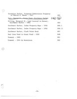
-15-
Southwest Harbor, Proposed Subdivision Property
of Marion G. Meade - 1947
801
Dorr, George R Great Pond. Southwest Harbor
CBD
802
Gilling, Margaret W. , Land Located in Manset,
Southwest Harbor - 1964
805
Southwest Harbor, Index Property Maps - 1956
806.1
Southwest Harbor, Index Property Maps - 1956
806.11
Southwest Harbor, Clark Point Road
807
Seal Cove Pond to Great Pond - 1920
808
Tremont - 1965
901
Tremont - 1954 by Kenniston
902
-16-
Mount Desert Island (1955) JDR, Jr.
186
Legend of Park Boundaries of Rockefeller Lands (2)
187
Mount Desert Island-1958 JDR, Jr. (Lots 334, 340, 345)
188
Bar Harbor and Mount Desert Island (1958) JDR, Jr.
189
Seal Harbor Realty Co. Lands Transferred to JDR, Jr.
(1936), Tract No. 5
190
Echo Lake Long Pond - South End, Land of JDR. Jr.
Dorr) USA and Wild Gardens
CBT
191
Seal Harbor (1961), Nelson A. & David R.
192
Mount Desert Island - Property Key Map (1956) JDR, Jr. 193
Seal Harbor (1959) (4) Nelson A. Rockefeller
194
Mount Desert Island (1959) (3) JDR, Jr.
195
Sargeant Point, Mount Desert Island (1959) JDR, Jr.
(Lot No. 302)
196
Eagle Lake, Bar Harbor - North End, JDR, Jr. to USA
197
Seal Harbor (1958) . Van Dyke to Nelson A.
198
Mount Desert Island, Western Mount Area (1961)
JDR, Jr. Estate and USA
199
Seal Harbor (1957) NAR
200
Seal Harbor (1960) David Rockefeller 7.34 Acres
201
Salisbury Cove, JDR, Jr. & Wild Gardene
CBD
205
Bar Harbor (1959) JDR, Jr.
210
Mount Desert Island (1956) JDR, Jr.
211
Northeast Harbor, Asticou, (Lots Nos. 292-2,
292-1-X, 292-2-X, 299, 300, 301-2, 301-3,
301-1-X, 306, 307, 307A)
216
Bar Harbor, Mount Desert Island (1958) JDR, Jr.
(Lots Nos. 175, 346, 347)
218
Mount Desert Island (1959) JDR, Jr. (Lots Nos.
341-1, 341-2, 341-3)
219
-7-
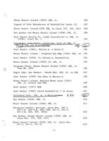
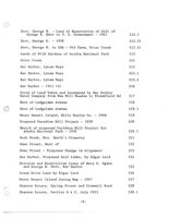
Dorr, George B. - Land of Reservation of Gift of
George B. Dorr to U. S. Government - 1941
512.7
Dorr, George B. - 1938
512.31
Dorr, George B. to USA - Old Farm, Otter Creek
512.41
Lands of Wild Gardens of Acadia National Park
513
Otter Creek
514
Bar Harbor, Lynam Maps
515
Bar Harbor, Lynam Maps
515.1
Bar Harbor, Lynam Maps
515.2
Bar Harbor - 1911 (3)
516
Strip of Land Taken and Condemned by Bar Harbor
Water Company from New Mill Meadow to Bloomfield Rd
517
West of Ledgelawn Avenue
518
West of Ledgelawn Avenue
518.1
Mount Desert Island, Hills Realty Co. - 1968
519
Proposed Paradise Hill Project - 1939
520
Sketch of proposed Paridise Hill Project for
Adadia National Park - 1939
520.1
Duck Brook, Mrs. Smith's Property
521
Eden Street, West of
522
Eden Street - Proposed Change in Alignment
523
Bar Harbor, Proposed Golf Links, by Edgar Lord
524
Division and Restriction Lines of Mary E. Ogden
and George B. Dorr, Bar Harbor
525
Ocean Drive Land by Edgar Lord
526
Mount Desert Island Zoning Map - 1957
527
Shannon Estate, Spring Street and Cromwell Road
528
Shannon Estate, Section B & C, July 1953
528.1
-9-
Shannon Estate, Section A (Ledgelawn Avenue)
528
Hulls Cove Lot, Roy Hamor
529
Schooner Head, July 1819, Rev. 1900
530
Acadia National Park - 1936 (3)
531
Lee Estate, Lot 16, Hulls Cove - 1936
532
Lee Estate, Lot 17, Hulls Cove - 1936
533
Salisbury Cove Property, Eden Agricultural
Society - 1938 (2)
534
Thirlstance Road
535
Seal Harbor, Merle-Smith Pyle, Dorothy Prop. - 1957
536
Ledgelawn Avenue - 1907 by Edgar Lord
537
Seal Harbor, Subdivision for Hills Realty Co. - 1965
538
Ash, Spring, School, Ledgelawn, Cromwell,
Harbor Road
539
Hawkes, Morris (Mrs) Property - 1925
540
Plan of Steepways - 1920
541
Plan of Steepways - 1906
541.1
Eden Street
541.4
Hoyt, Carmelia B. Property, Plan of Westoner, - 1915
541.5
Cleftstone Road
542
Cleftstone Road
542.1
Cleftstone Road
542.2
Beale, William Property, Plan of Kragmyr, - 1921
543
Eden Street, Highbrook Road
544
Acadia National Park (Near Ledgelawn), Great
Meadow Hill Area
545
Mount Desert Island, Building Zoning Map (1939)
546
-10-
Land of Indian Point - 1952
547
Colby & Stuart - 1887
548
Index Map of Bar Harbor & Vacinity - 1903
549
Bar Harbor School District - 1951
550
Seal Harbor, Wallace Harrison Property (1961)
551
Bar Harbor, Fred Lynam
552
Topographic Plan of Town of Bar Harbor - Ground Floor
553.1
Topographic Plan of Town of Bar Harbor - 1966
553.2
Shore Property Subdivision, Vacinity of Indian
Point, Bar Harbor - 1962 (5)
554
Seal Harbor, Harbor Club Cottages - 1955
555
Floor Plan Elevations
Interior Elevations
Kitchen & Bath Plans & Elevations
Wall Details-Door & Sill Details
Laundry Building
Cottage No. 1
Plan of Land Ownership of Park Office to Great
Meadow, Bar Harbor, Sheet No. 1 - 1941
556
Mount Desert Island, Sanders and Scott Property
& Environs, U. S. Chart No. 307 - 1938
557
Otter Creek Boundary Survey, Acadia National Park
558
Mount Desert Island and Adjacent Islands Embracing
Towns of Eden, Mount Desert Island, Tremont
and Cranberry Islands - 1880
559
Index to Exposures No 8740 Topographic
Map of Acadia National Park and Vacinity
560
Northeast Harbor, Asticou - 1955
561
Seal Harbor, Stephen R. Petschek Lot - 1963
562
Northeast Harbor, H.C. Rivers Property - 1965
563
-11-
Viewer Controls
Toggle Page Navigator
P
Toggle Hotspots
H
Toggle Readerview
V
Toggle Search Bar
S
Toggle Viewer Info
I
Toggle Metadata
M
Zoom-In
+
Zoom-Out
-
Re-Center Document
Previous Page
←
Next Page
→
Chapman Archive Map Index 1984
Details
Series 5

