
From collection HT Profile Reference Works

Page 1
Search
results in pages
reference work ~ Acadia National Park Motor Road Development drawing
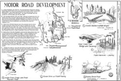
MOTOR ROAD DEVELOPMENT
A) Jordan Pond/Eagle Lake (1923-27): Park Superintendent George Dorr originally
planned this road in 1922 to open up the interior of the park to visitors and to protect
HISTORIC AMERICAN
RECORD
against wildfire. When federal appropriations for the road fell through, John D.
Frenchman Bay
Rockefeller, Jr. agreed to fund the project. The Jordan Pond/Eagle Lake road
connects Rt. 233 near Eagle Lake with Seal Harbor.
SHEET
B) Sieur de Monts (planned 1929, built 1940): Although not represented here, this
F
Bar Harbor
section of the Park Loop motor road was the most controversial to construct (see
Sieur de Monts Spring sheet). Originally designed to run alongside The Tarn, the
final layout went around Champlain Mt., connecting Ocean Drive and the Kebo Mt.
B
MAINE
section with the old park headquarters near downtown Bar Harbor (on
SCHOODIC
Ledgelawn Ave.).
PENINSULA
Varies
Reveal
1" Crown Per Foot
C) Ocean Drive (1929-58): Because much of its proposed route ran across
Eagle
The
privately owned land, Ocean Drive took longer to complete than any other
Lake
Tarn
0
1
2
Miles
F
section of the Park Loop motor road. As Acadia obtained these properties,
Granite Median (rumble strips)
0
2
3
more segments of Ocean Drive were added. The Ocean Path, a trail running along
A
Champlain Mt
Kilometers
lookout area - Paradise Hill
the road's southern portion, was reconstructed during the Depression by workers
scale 1/2" = 1'-0
from President Roosevelt's Civilian Conservation Corps (see Ocean Drive sheet).
Jordan
ME Rt.3
Pond
D) Stanley Brook (1934-36): Rockefeller constructed the Stanley Brook motor road
Somes
C
on his own land and then donated It to Acadia. In order to maintain the scenic
Sound
quality of both the brook and the narrow valley, as well as to alleviate local
opposition to the road, Rockefeller hired landscape architect Frederick Law
Olmsted, Jr. to help design it. The final route crosses Stanley Brook six times on
Otter Point
small, unadomed bridges. (Extensively landscaped by Beatrix Farrand).
Stanley
Brook
E
E) Otter Point (1938-39): The 1932 decision, relocating the Otter Cliff Naval Radio
Station to nearby Schoodic Peninsula made way for the extension of the Park Loop
motor road through Otter Point. Rockefeller donated the land for the Otter Cove
Causeway and confirmed the design with F. L. Olmsted Jr. A memorial to
Seal Harbor
HANCOCK COUNTY
Allesandro Fabbri, commander of the radio station, marks the station's former
Otter Creek Cove
0
7
2
location.
Miles
ACADIA NATIONAL PARK ROADS 8 BRIDGES
0
1
2
5
Bridge and Causeway
F) Paradise Hill (1940-41): One of the last sections of the park motor road to
Kilometers
be completed, the Paradise Hill Road was built so that motorists entering the park
from Rt. 3 could avoid Bar Harbor traffic. Although it was constructed by the
E
Bureau of Public Roads, the land for the road was
donated by Rockefeller.
To Bar Harbor
Fabbri Memorial - planting
BAR HARBOR VICINITY
P
PAT LANE
harlen d. groe , 1995
BRIDGES RECORDING PROGRAM
To Seal Harbor
A
D
BY
Stanley Brook Road
Jordan Pond / Eagle Lake Road
concept drawing -F.L. Olmsted Jr.
NATIONAL PARK SERVICE
: I :
C
Ocean Drive with Pulloff Parking
Mountain Road
DELINEATED BY
ACADIA ROADS 8
never implemented
Viewer Controls
Toggle Page Navigator
P
Toggle Hotspots
H
Toggle Readerview
V
Toggle Search Bar
S
Toggle Viewer Info
I
Toggle Metadata
M
Zoom-In
+
Zoom-Out
-
Re-Center Document
Previous Page
←
Next Page
→
reference work ~ Acadia National Park Motor Road Development drawing
Drawing of motor road development in various locations at Acadia National Park. Reference work only; not accessioned in History Trust members' collections.

