
From collection Subject List

Related Items

Photocopy of Colby & Stuart Map of Mount Desert and adjacent islands (1887)
Colby & Stuart map includes villages of Mount Desert, physical landmarks, adjacent islands in 1887. This is a blue print of the map. Size: 30 inches by 40 inches.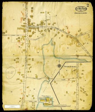
Map 2 of the Sanborn Maps of Southwest Harbor, ME, 1921
An image of Map 2 of the Sanborn maps in MDI Historical Society collection. Scan made by Charlotte Morrill, SWH, April, 2011. There are two images of this map attached to this record. One image of the map includes the MDI Historical Societ…
The Island of Mount Desert Maine (colored and annotated in 1966 by Tom Culverwell)
Printed copy of 1966 color map drawn by Tom Culverwell, annotated to show location of historic sites and villages on Mount Desert Island, and also contemporary roads, mountain names, cove names, ferry routes and campgrounds. Includes Cranb…
Photocopy of Colby & Stuart Map of Mount Desert and adjacent islands (1887)
Colby & Stuart map includes villages of Mount Desert, physical landmarks, adjacent islands in 1887. This is a blue print copy. size: 30 by 40 inches
Photocopy of Colby & Stuart Map of Mount Desert and adjacent islands (1887)
Colby & Stuart map includes villages of Mount Desert, physical landmarks, adjacent islands in 1887. This is a blue print copy. size: 30 by 40 inches
Transparency of Colby & Stuart Map of Mount Desert and adjacent islands, 1887
Colby & Stuart map includes towns of Eden, Mount Desert, Tremont, Cranberry Isles; physical landmarks, adjacent islands (1887). This mylar transparency may be used to make copies of the map. size: 30 by 40 inches Scale: 1 mile=1 inch
Photocopy of Colby & Stuart Map of Mount Desert and adjacent islands (1887)
Colby & Stuart map includes villages of Mount Desert, physical landmarks, adjacent islands in 1887. This is a blue print copy. size: 30 by 40 inches
Photocopy of Colby & Stuart Map of Mount Desert and adjacent islands (1887)
Colby & Stuart map includes towns of Eden, Mount Desert, Tremont, and Cranberry Isles; physical landmarks, adjacent islands in 1887. Scale: 1 mile=1 inch This is a blue print copy. size: 30 by 40 inches
Photocopy of Colby & Stuart Map of Mount Desert and adjacent islands (1887)
Colby & Stuart map includes villages of Mount Desert, physical landmarks, adjacent islands in 1887. This is a blue print copy. size: 30 by 40 inches

