
From collection Jesup Library Maine Vertical File

Page 1

Page 2
Page 3
Page 4
Page 5
Page 6
Page 7
Page 8
Page 9
Page 10
Page 11
Page 12

Page 13
Page 14
Page 15
Page 16
Page 17
Page 18
Page 19
Page 20
Page 21
Page 22
Page 23
Page 24
Page 25
Page 26
Page 27
Page 28
Page 29
Page 30
Page 31
Page 32
Page 33
Page 34
Page 35
Page 36
Page 37
Page 38
Page 39

Page 40
Search
results in pages
An Island In Time: Three Thousand Years of Cultural Exchange on Mount Desert Island
THE ROBERT ABBE MUSEUM
Bar Harbor, Maine
1989
BULLETIN XII
An Island in Time
Three Thousand Years of Cultural
Exchange on Mount Desert Island
Jesup Memerial Library
34 Mt. Decent at
Bar Harber, ME 04809
Cover Design by Cathy Brann
Photography and Graphics by Stephen Bicknell
Copyright © 1989 by The Robert Abbe Museum.
All rights to reproduce this book, or portions thereof, reserved.
375
THE ROBERT ABBE MUSEUM
Bar Harbor, Maine
1989
BULLETIN XII
An Island in Time
Three Thousand Years of Cultural
Exchange on Mount Desert Island
Essays by
David Sanger and Harald E. L. Prins
Edited by
Ann McMullen and Diane Kopec
Introduction
"An Island in Time: Three Thousand Years of Cultural Exchange
on Mount Desert Island" is both an exhibition and a publication. The
exhibition, made possible by a major grant from the Maine
Humanities Council and awards from the Elizabeth B. Noyce Fund of
the Maine Community Foundation and the Atwater Kent
Foundation, opens at the Abbe Museum, Bar Harbor, in May of 1989
and at the Hudson Museum, University of Maine, Orono, in
December of 1989.
The exhibition explores Native American cultural continuity and
change on the central Maine coast, focusing on Mount Desert Island.
Using Indian artifacts, a wigwam representation, artifacts from Jesuit
missions, maps and illustrations, and insights from the disciplines of
archaeology, anthropology, history, and ethnohistory, the exhibition
investigates the interactions, perceptions, and exchanges between
Native American and European cultures, especially the French and
English.
This publication accompanies the exhibition, but is also meant to
provide the public with a prehistoric and historic account of the Native
Americans of Mount Desert Island, from 3,000 years ago through the
time of exploration and settlement by Europeans. It complements the
exhibition by expanding upon its theme and fills a gap in the literature
on the Indians of Mount Desert Island and the Contact period.
The first essay, by Dr. David Sanger, focuses on Mount Desert
Island's prehistoric populations, in particular, those living at the
Fernald Point site. In "Insights into Native American Life at Fernald
Point," Dr. Sanger sets the stage by providing an overview of the
environment and food resources available to the Indians at Fernald
Point. He presents a picture of pre-European life on Mount Desert
Island, describing the tools, their uses and native methods of procuring
food, as well as examining the question of site seasonality. Dr. Sanger
ends this wonderful picture of early life on Mount Desert Island with a
word of caution about sites at risk due to continuing coastal erosion.
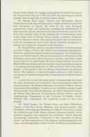
Dr. David Sanger, Professor of Anthropology and Quaternary
Studies at the University of Maine. Orono, has conducted prehistoric
archaeological research in British Columbia, the northwestern United
States, the Canadian Maritimes and the northeastern United States.
His research has focused on paleo-environmental archaeology and
prehistoric adaptations to maritime environments. An area of special
interest to Dr. Sanger is the central Maine coast, which includes
1
Mount Desert Island. Dr. Sanger excavated the Fernald Point site for
the National Park Service in 1975 and 1976, thus providing us with an
intimate look at early life on Mount Desert Island.
Dr. Harald Prins' essay, "Natives and Newcomers: Mount
Desert Island in the Age of Exploration," begins with the arrival of the
first Europeans in Maine. He looks at the early European
explorations, trade, and settlement, including the establishment of
Saint Sauveur mission, the first Jesuit mission in North America. Dr.
Prins also explains some of the complexities of determining which
Indian tribes lived on Mount Desert Island, a question frequently
asked by Museum visitors. His essay looks at the time of exploration
from the European as well as the Native American perspective, a
balance not frequently expressed in the literature.
Dr. Harald Prins, currently Assistant Professor of Anthropology
at Colby College in Waterville, Maine, has conducted ethnographic,
historical, and archaeological research in Argentina, The Netherlands,
Israel, and North America. His current research is on the history of the
Wabanaki culture area Indian-European relations, and Native rights
issues in the U.S.A. and Canada. He works closely with the Aroostook
Band of Micmac Indians and various other American Indian groups as
a consulting anthropologist and, in 1985, produced "Our Lives in Our
Hands," a documentary film on Micmac basketmakers in northern
Maine. His expertise in Indian-European relations is well suited to
increasing our understanding of the Contact period on Mount Desert
Island.
I would like to take this opportunity to acknowledge and thank
the many institutions and individuals whose participation made this
project a success. The Hudson Museum, University of Maine, Orono,
cosponsored the exhibition. Lenders to the exhibition include Acadia
National Park, Fort Western Museum, the Maine Historical Society,
the Maine State Museum, the Southwest Harbor Library, and the
Anthropology Department of the University of Maine, Orono.
Without their cooperation, the exhibition would not have been
possible.
Dr. David Sanger, Dr. Harald Prins, and Ruth Whitehead,
Curator of the Nova Scotia Museum, were project scholars. Ann
McMullen, Anthropology Department of Brown University, curated
the exhibition and Cathy Brann, Hudson Museum Graphic Artist,
produced graphics and designed the exhibition. Steven Bicknell,
Archaeology Laboratory Technician at the University of Maine,
Orono, led the construction of the wigwam, produced graphics and
maps, and photographed artifacts for the exhibition and publication.
2
I would also like to thank Dr. Richard Emerick, Joan Klussmann,
and Gretchen Faulkner, Hudson Museum; Jack Hauptman, Deborah
Wade, Meg Fernald and Ed King, Acadia National Park, National
Park Service, Bar Harbor; Paul Rivard, Dr. Bruce Bourque,
Madeleine Fang, Allyson Humphrey, and Robert Lewis, Maine State
Museum, Augusta; Elizabeth Miller, Maine Historical Society,
Portland; Richard D'Abate and Dorothy Schwartz, Maine
Humanities Council, Portland; Jeffrey Zimmerman and Jay Adams,
Fort Western Museum, Augusta; Theodore Mitchell, Office of Indian
Programs and Minority Services, University of Maine, Orono; Robert
Chute, Bates College, Lewiston; Judith Cooper, Center for the Study
of the First Americans, University of Maine, Orono; Pauleena Seeber,
Glenburn; Charles Paquin, Archaeology Research Center at the
University of Maine, Farmington; Jeffrey Kalin, Primitive
Technologies, Inc., Bethlehem, Connecticut; Mark Mowatt, World
Fur Corporation, Brewer; Russ Hewitt, Pride Manufacturing
Company, Guilford; William Belcher, Quaternary Department,
University of Maine, Orono; Suzanne Nash, Hulls Cove; Carole Beal,
Bar Harbor; Betts Swanton, Bar Harbor; George Vose, Jackson
Laboratory, Bar Harbor; Maine State Library, Augusta; Lee
Cranmer, Maine Historic Preservation Commission, Augusta; Dr.
Susan Kaplan, Peary-MacMillan Arctic Museum, Bowdoin College,
Brunswick; Susan Danforth and the John Carter Brown Library,
Brown University, Providence, Rhode Island; The Public Archives of
Canada, Ottawa; Thomas Gilcrease Institute of American History and
Art, Tulsa, Oklahoma; and the Kendall Whaling Museum, Sharon,
Massachusetts.
The long list of participants is proof of the truly inter-
organizational nature of the exhibition project. Thanks to all of the
individuals and organizations who helped bring "An Island in Time"
to the public.
Diane Kopec, Director
Abbe Museum
3
Insights Into Native American Life
at Fernald Point
David Sanger
"And on your left you see archaeologists
" blared the
loudspeaker from the cruise boat carrying another group of summer
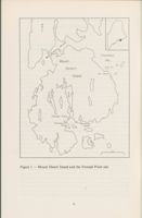
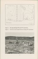
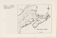
visitors up beautiful Somes Sound (see Figure1). It was July 1977, and
a crew of six archaeologists from the University of Maine diligently
excavated an important American Indian campsite-the Fernald
Point site. By now the crew was almost oblivious to the boat traffic
that monitored their activities.
The Fernald Point story began thousands of years before, when
Native Americans first selected this strategic point for a camping
place. It had everything they needed-a gentle beach for landing
canoes, with a soft bottom that would not damage the birchbark skin,
and vast quantities of soft-shell clams. No one would go hungry as long
as the clams held out. Coming in over the mudflat with every tide there
would be sculpin and flounder, which a simple brush weir could entrap
as the tide fell. The beach faced south SO that even on the coldest winter
day sun would shine right into camp, while behind was a forested hill
that protected the village from bitter north winds. Fish and seals
passed by the front door on their way up and down Somes Sound. Yes,
this was an ideal spot, perhaps a little exposed to swells, but not too
bad at all. And just look at the beautiful surroundings: trees coming
right down to the water's edge everywhere, and hills rising up behind.
Some things have stayed the same, but others have changed since
people first lived at Fernald Point about 1000 B.C. Should one of the
original Fernald Point inhabitants revisit the area, he or she would
notice some remarkable differences. Most notably, one suspects,
would be changes in landscape and land-use patterns. To make the
nineteenth-century farm fields, trees were cut down, and later summer
cottages began to dot the shoreline.
Other changes have occurred. The form of the beach gradually
changed in response to a rise in sea level of over six feet since 1000 B.C.
As the high water mark came up, erosion cut into the beach and
washed away the soft, muddy sediments of the mudflat, leaving
pebbles and stones that could resist better the ebb and flow of the tide.
Through time, then, the constantly rising sea level altered many of
those characteristics that had made the site attractive to the Indians in
the first place. Ironically, the gently sloping beach, that initially proved
ideal for small boat launching and landing, as well as an excellent clam
5
N
Frenchman
Mount
Bay
Desert
bood
Bar Harbor
Island
Fernald Point
Southwest
Northeast
Harbor
Harbor
0
kin
O
5
Figure 1 - Mount Desert Island and the Fernald Point site.
6
habitat, proved to be the cause of the site's abandonment shortly
before the arrival of the strangers from Europe.
In the early 1970s, the deteriorating situation at Fernald Point
and at other archaeological sites in Acadia National Park was brought
to the attention of park officials; because of Native Americans'
tendency to locate sites on soft terrain where mudflats are found,
natural destruction of sites was commonplace. And, though every
National Park wants to protect its historical and archaeological
resources, the Park Superintendent lacked the funds to even begin to
determine the extent of the problem-an archaeological site survey to
assess the resource and its condition.
After a period of frustration, a short note to Washington brought
about instant results: a small contract between the Park Service and
the University of Maine to conduct a systematic survey of the
shorelines in Acadia National Park. The report of this initial survey
noted a number of sites, discussed their condition, and made
recommendations. One site emerged as extremely important-the
Fernald Point site. Not only was erosion taking a toll, but the exposed
bank had encouraged people to dig into the site to recover artifacts for
private collections, an activity which was, of course, illegal. In keeping
with its significance, the site was placed on the National Register of
Historic Places.
Having identified the problem, money was again a difficulty.
Some funds dedicated for "ruins stabilization" work materialized, and
a plan was drawn up to conduct a limited excavation, especially in the
area most affected by the sea erosion and public looting. To further
protect the site, boulders would be placed along the front of the site to
help inhibit erosion.
Based on some 1976 testing, research assistant Barbara Johnson
and David Sanger made plans for the 1977 season. Johnson would
take a crew of seven experienced excavators to Fernald Point for six
weeks; the crew would test the eroding front of the site, as well as parts
of the site further back in the field. Large scale excavations, however
desirable, were out of the question; there simply were not enough
funds to do a thorough job.
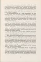
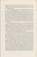
As the site map shows (see Figure 2), we concentrated our
activities largely along the eroding front of the site. Excavation
proceded by hand-held trowels and all site deposits were screened
through 1/4-inch mesh (see Figure 3). In this way, very small bones
and artifacts the excavator might miss could be recovered.
7
Fernald Point Site
20
Housepit
Beach
III
1976 Excavation Unit
1977 Excavation Unit
cm
O
5
C.I. 0.25m
Figure 2 - Site map showing 1976 and 1977 excavations.
Figure 3 - Overview of the Fernald Point site during 1977 excavation.
8
Excavation destroys a site, no matter how carefully the work is
done. Because of this, it is imperative that maximum attention be paid
to documentation through field notes, drawings, and photographs.
We cannot, of course, record everything; some compromises must
occur if we are to excavate enough of the site to make any statements
about the people who lived there. Then, too, continued site erosion
creates a sense of urgency.
The Fernald Point site was a large shell midden. The term
"midden" comes from a Scandinavian word that refers to kitchen
wastes. Shell midden, then, refers to the leavings of people who lived at
a site and deposited their kitchen trash, shells, bones, broken
implements, and the like. For the archaeologist this is a gold mine of
information. In the absence of written records, this is all we have to
reconstruct past lifeways.
There is an added bonus to excavating shell middens as opposed
to sites in the wooded interior of Maine. Maine soils are normally
acidic. In such environments bones rapidly decay, with the result that
most interior sites rarely have much preserved evidence for the animals
people ate. Shell middens, by contrast, result in excellent preservation
because the shells, being composed largely of calcium carbonate,
neutralize the normal soil acidity, resulting in better preservation of
bone and other organic materials.
From our excavations at Fernald Point, and with information
from other sites in the region, we can begin to present a picture of pre-
European life on Mount Desert Island.
Often the questions most commonly asked of an archaeologist are
the most difficult to answer: "What tribe lived here?" During historic
times, the period after about A.D. 1600 for which we have the written
records of Champlain and other explorers, the Mount Desert Island
area was inhabited by people whose descendants now focus on Indian
Island, home of the Penobscot Nation. But when we get back into
prehistory, before written records, we depend on oral traditions
supplemented by archaeology. It is quite possible that ancestors of the
modern Penobscot lived at places like Fernald Point for millennia
before the arrival of the Europeans.
A second question, as perplexing as the first, is "How many
people lived at this site?" Once again we have to equivocate. In the first
place we don't know the full size of the site. While we can get an idea of
how large it is today, who can say how much has eroded away through
time? And, to further complicate matters, just because a campground
can accommodate fifty tents does not mean that fifty tents were always
9
pitched. My guess would be that the size of the population varied
through time, and even in any one year people might come and go.
Somewhere between twenty-five and fifty residents at one time would
be a reasonable guess.
A third important question is, "When did they live here?" Since
the late 1950s, archaeologists have made excellent use of the
radiocarbon dating technique, which measures the amount of carbon-
14, a radioactive isotope of carbon that is a constant value in all living
plant matter, but decays after the plant dies. By measuring the amount
of carbon-14 in a sample of wood or charcoal from a site, an estimate
of the death date of the tree is made. At Fernald Point we obtained
dates ranging from a little over 2,000 to about 700 years ago. However,
based on the similarities between some tools found at Fernald and at
other nearby sites, we place the date of the first occupation at around
1000 B.C. From A.D. 1 until about A.D. 1300 the site was utilized
quite heavily.
The inhabitants of Fernald Point were what archaeologists call
"hunters and gatherers," meaning that they did not practice
agriculture as far as we know. In Champlain's time, agriculture had
spread up the coast to the mouth of the Saco River, and perhaps even
to the Kennebec River, although the evidence is not clear. Even in
southern New England, the growing of corn (maize), beans, and
squash was a relatively recent development, not much older than A.D.
1000, according to recent archaeological evidence.
Buried in the various shell layers at Fernald Point are bones of sea
and land mammals, birds, and fish. Not represented, perhaps due to
preservation factors, were the results of gathering wild vegetable
foods, like berries, roots, and nuts. Simply because evidence of these
foods is not present does not mean that they were not consumed. We
assume that they were part of the diet of the Fernald Point people.
An examination of the bones and shells from Fernald Point
indicates a diet that balanced land and sea species (see Figure 4).
Shellfish remains are mostly of the soft-shell clam, found everywhere
on the central and northern Maine coast. Blue mussels were taken
from their perch on rocks and ledges, and would have constituted a
readily available and predictable resource available at any time of
year. As in some other societies, shellfish gathering may have been a
task taken on by women and children while the men were hunting. The
clams were probably opened by steaming them on the rock hearths we
found at the site; there are few signs of damage to shells resulting from
deliberate breakage. While most shellfish were probably eaten almost
10
Mammals
Birds
Fish
White-tail deer
Great auk
Winter flounder
Moose
Greater scaup
Longhorn sculpin
Harbor seal
Common eider
Atlantic cod
Black bear
White-winged
Wolffish
Sea mink
scoter
Striped bass
Gray seal
Black duck
Dogfish
Beaver
Canada goose
Haddock
Muskrat
Common merganser
Tomcod
Hare
Double-crested
Ocean Pout
Porcupine
merganser
Sea Raven
Raccoon
Great blue heron
Alewife
Gray fox
Grebe
Sturgeon
River otter
Old squaw
Soft-shell clams
Porpoise
Owl
Blue mussels
Dog
Hawk
Sea urchins
Eastern cottontail
Bald eagle
Whelks
Note: these animals are not listed in order of importance.
Figure 4 - List of animal remains found at the Fernald Point site.
immediately, some may have been dried for future use, although there
is no evidence for that practice in the archaeological record.
Other harvests from the sea included fish of several species.
Altogether, the excavation team recovered over 14,000 fish bones,
mostly sculpin and flounder which feed on the mudflats at high tide.
The retrieval of fish from brush weirs set into the mudflat at the front
of the site might also have been the task of women as they dug clams.
Cod, a deeper-water fish sometimes found in Maine coastal sites, were
infrequent at Fernald Point. Sea urchins and other delicacies were also
taken by the local inhabitants. Strangely, they seem to have avoided
lobsters; we have found only one claw in twenty years of excavation in
coastal Maine sites.
The sea also provided seals and a few porpoises. Whaling was not
practiced. Birds, while not common, are mostly sea-oriented species,
such as eiders and great auk.
From the land, the hunters brought home white-tail deer, bear,
and an occasional moose. Beaver remains were quite common at the
Fernald Point site, although muskrat were rare, probably due to the
lack of a suitable local habitat. The remains of sea mink, an extinct
species about the size of a small cat, were also present at Fernald Point.
11
Very few of the bones from the site exhibit any evidence of burning,
which suggests that food was most likely boiled in clay pots or cooked
by steam generated in the numerous stone hearths, much like a
traditional Down East clambake. The bones themselves were split and
cooked for their marrow content, which would have been an
important component of the diet, especially in cold weather.
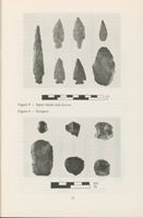
The artifacts found at the Fernald Point site provide some clues as
to how these various food sources were procured. There are a number
of arrow or spear heads chipped from stone available along the
beaches of the area, or from local outcrops of volcanic rock (see Figure
5). The forms and sizes of these tools changed through time, from
larger to smaller, including different bases, which provided a means to
lash the arrowhead to a shaft. These changes were not random; at
certain times in the past people made their arrowheads within
a
particular range of variation. Understanding how tool types changed
through time helps us to estimate the age of a particular deposit.
We do not think the forms of tools necessarily changed because of
increased technological efficiency, any more than clothing styles
change today as a measure of efficiency.
Another artifact type made of chipped stone is a tool that
probably functioned as a knife (see Figure 5). Archaeologists often call
these tools bifaces because they are worked on both faces or sides.
Some artifacts put in this category may actually represent lost or
damaged items that were intended to have been arrowheads.
Scrapers are common at Fernald Point (see Figure 6). We think
these tools functioned to scrape away fat from the inside of hides,
although they could have been used for other tasks as well. Scrapers
are usually made by removing flakes from only one side of a larger
stone flake. While many of the rocks could be gathered locally, some
rocks probably came from across the Gulf of Maine in Nova Scotia.
Woodworking would have been an important component of
camp activities at Fernald Point. While the wood has long since
deteriorated, we did find stone axe and adze blades, as well as the lower
incisors of beaver, used to carve wood, much like a modern crooked
knife.
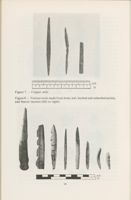
Metal was rarely used prehistorically. At Fernald Point, the only
examples are a few awls made of naturally-occurring copper which
was cold-hammered and folded to shape rather than smelted (see
Figure 7).
Animal bone constituted a useful raw material for tools (see
Figure 8). Shaped and polished long bones could be used for awls,
needles, harpoons, and spears. Small bone points might have formed
barbs on wooden hooks for line fishing.
12
IMA
....
cm
in
Figure 5 - Spear heads and knives.
Figure 6 - Scrapers.
cm
in
13
cm
in
Figure 7 - Copper awls.
Figure 8 - Various tools made from bone: awl, barbed and unbarbed points,
and beaver incisors (left to right).
cm
in
14
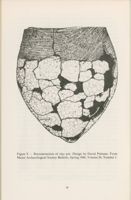
Containers for food, water, and possessions are always needed
around the home and camp site. Starting around 500 B.C. the Indians
of Maine began making clay pots, after the fashion of peoples to the
south and west. While there were no complete pots found at the
Fernald Point site, there are numerous fragments, or sherds, that span
the range from the earliest vessels used in Maine through later
prehistoric types.
The vessels were made of locally available clay (actually a silt laid
down by higher sea levels 12,000 years ago), mixed with gravel and
coarse sand, called temper, which later gave way to crushed shell
temper after about A.D. 1000. The conical pots were usually built up
by coils, smoothed, decorated, and then fired in an open fire hearth.
The resulting vessels were unglazed and porous until coated on the
inside with accumulated fat from cooking (see Figure 9).
The majority of pots were decorated before firing. Initially,
designs were made with a small carved wooden or bone stamp that left
tooth-like impressions on the vessel; these are known as "dentate
stamped" pots. Sometime around A.D. 1000 a new technique became
common in the Northeast and vessels were decorated by a stamp made
of a cord or string wrapped around a stick or paddle. Archaeologists
call these "cord-wrapped stick" ceramics. Like the arrowheads, styles
in decoration changed through time. However, the plastic nature of
clay lends itself to manipulations that leave much better traces of style.
Archaeologists in Maine can now gauge the age of a vessel to within a
two- or three-hundred-year period. In other parts of the world it is
possible to estimate the age of a site much more accurately, within
decades, with the aid of pottery. While we refer to the markings on
pottery as "decoration," this might not have been in the mind of the
maker. He, or more likely she, may have labelled the pot with the
insignia, or crest, of her family, clan, or tribe.
Our excavations at Fernald Point located one definite house and
possibly another. The nearly intact house had been partially destroyed
by erosion. Although we did not excavate all of the remaining portions
of the house due to time restrictions, we were able to recover some
information on its size and shape. In all respects it resembled many
other houses our crews have excavated on the Maine coast. The typical
house was oval, about eight to twelve feet long by eight to ten feet wide,
for a floor area of less than one hundred square feet. The shape was
always oval. Depending on the period, the house might rest on the
surface or it may have been dug into the soil or into an older midden
deposit, SO that up to two feet could be below ground level. A number
of poles, resting on the outside of the house depression, provided the
15
Figure 9 - Reconstruction of clay pot. Design by David Putnam. From
Maine Archaeological Society Bulletin, Spring 1986, Volume 26, Number 1.
16
supports for a conical covering, probably of birchbark. Sometimes
rocks were used to help support the poles. Inside there was a hearth,
usually situated towards one end of the house near the entrance.
In excavations we frequently recognize housepits by layers of
midden that are relatively shell-free. These shell-free strata appear to
be the result of sand and gravel brought up from the beach and strewn
over the floor to form a clean, smooth surface (see Figure 10). With
time these floors got dirty from household activities and another layer
of clean sand was brought in. Eventually, the house depression was
filled up.
Whether each floor represents one season or less is not clear. At
Fernald Point the house seems to have been utilized around A.D. 800
and again at A.D. 1200, based on radiocarbon dates and the kinds of
pottery found. The evidence suggests that the later group, seeing a
ready-made cellar, moved right in.
495 50E
49S52E
49S54E
Column 5
VI
Central
Hearth
VII
VII
cm
Rock
Sod
Loam
Shell
IV
Gravel
V
Charcoal Stained Gravel House Floor
VI
Ash
VII
Subsoil
Figure 10 - Stratigraphy of housepit 1 showing charcoal stained gravel floor.
Another clue to the presence of a house floor is an increase in the
number of artifacts and rejected raw materials, indicative of
manufacturing taking place in the house. Summer houses may have
many fewer artifacts inside, as the better weather would encourage
outdoor work. In the Fernald Point house we found a number of
specimens in the house deposits.
Houses tended to be built toward the back of a site, away from the
beach, while the midden or dumping area developed by the beach.
Because we were concerned with the erosion problem and the front of
the site, we did not uncover additional houses. Information from other
similar sites suggests that settlements of this period contained a
number of houses rather than just one.
17
In prehistoric times, people living on the coast of Maine had to
have water transportation. Unfortunately, physical evidence for boats
is extremely rare in the archaeological record. Historically, the
birchbark canoe was ubiquitous in Maine. This lightweight, yet highly
seaworthy craft, was capable of making substantial journeys. Ocean-
going canoes, up to 25 feet in length, were in common usage during
historic times. Because we find sites that are up to 5,000 years old on
the outermost islands, we know canoe travel has had a long history in
the Maine area.
One of the prominent questions in Maine prehistory has been the
matter of seasonality: what time of the year did Indians spend in their
coastal settlements? It has been said that the Indians spent their
summers on the coast and retired during the winter to traditional
hunting and trapping grounds in the interior. However, such a pattern
seems to have been prevalent only after the arrival of Europeans.
Archaeological evidence indicates possible year-round settlement in
coastal environments, but not necessarily at one site.
This evidence comes from two related sources. One source is
provided by the presence or absence of seasonally specific animals. For
example, some birds are winter residents on the coast, others are
summer, and still others are migratory. The identification of bird
remains helps to determine when particular activities took place at the
site. Fish may go through migratory patterns, as may marine
mammals.
A second source of information comes from changes that resident
species undergo through the year. Mammals, for example, develop
annual growth layers on their teeth. When the teeth are cut open and
examined, an estimate of seasonality can be obtained. Male deer drop
their antlers in the winter. Therefore, a skull of an adult male deer with
evidence that the antlers have dropped naturally indicates a winter kill.
Clams have an annual growth cycle followed by a period of quiescence,
much like a tree ring. Because they are SO common in shell middens, we
can examine hundreds of shells to find out what season the clams were
dug. If we assume that the season of procurement was also the time of
living at the site, then we have a useful method of determining site
seasonality.
The evidence indicates that the Fernald Point site was used both
in warm and cold seasons, but that does not mean it was used year-
round. Summer occupation could have been followed by occasional
winter use. At this time, too little of the site has been excavated to
allow us to make any more definitive statements, although evidence
from the house at Fernald Point almost certainly refers to a winter
occupation.
18
Of the ceremonial or religious way of life at Fernald Point we
know comparatively little. The site is, of course, a habitation and we
should not expect to find much evidence for the spiritual side of life.
Our excavations did encounter a group of four burials at the eroding
bank edge. It is clear that they were carefully placed into the midden,
but few artifacts accompanied the remains. The graves may be
unrelated to the other findings at Fernald Point, and represent the
deceased of another group. The burial took place around A.D. 1100;
midden burial is generally rare in Maine.
It would be a mistake to think of the Fernald Point people as
living in a social vacuum. The presence of artifacts made from rocks
thought to be from Nova Scotia indicates contacts across the Gulf of
Maine in prehistoric times. Evidence from recent excavations near
Yarmouth, Nova Scotia, hints that journeys across the one hundred
miles of open water to Yarmouth had been going on since 2,000 B.C.
If there was a year-round presence of people on the coast of
Maine, then the many sites in the interior suggest a resident,
permanent, interior population. Undoubtedly, there was
intermarriage with the interior groups as well. The Penobscot speak of
inland and water clans, or family groups, a clear suggestion that people
of a single ethnic identity occupied both coastal and interior terrain.
Intermarriage between clans would establish in-laws in both areas,
always a useful relationship in a land where resources might vary.
Over the years, speculative literature about pre-Columbian
European voyagers to the coast of Maine has become popular.
However common, these claims lack any evidence to convince
professional archaeologists of such travels.
There is much more we would like to know about Fernald Point
and the people who lived there off and on for over 2,000 years. Some of
this information is irretrievable because it has been eroded away by the
effects of sea-level rise in the area.
What is the potential for the Fernald Point site to yield additional
secrets? The seawall put in place in 1977 has stood up very well, and did
yeoman service during the big storm in the winter of 1978. There are
signs, however, that the boulders may be losing some of their
effectiveness, and that erosion will again become a factor. Our efforts
recovered information that would otherwise have been lost many years
ago. It remains to be seen, however, whether we can respond when the
inevitable reoccurs, and the Fernald Point site is again at risk.
19
Natives and Newcomers
Mount Desert Island
In The Age Of Exploration
Harald E. L. Prins
What Happened In Maine Indian History?
In the late nineteenth century, only a few Penobscot elders could
still recount the myths, legends, and stories of events long past. The
traditions and collective memory of Maine's tribespeople were held in
these oral tellings; without them, the native legacy would be lost. In
1893, trying to preserve his tribal heritage, Joseph Nicolar recorded
these oral traditions "handed down from the beginning of the red
man's world to the present time."
In contrast to accepted anthropological theory which states that
Maine's contemporary tribespeople descend from PaleoIndian big-
game hunters who migrated from Siberia some fourteen thousand
years ago, native tradition holds that Gluskap, the first human, came
into being "when the world contained no other man, in flesh, but
himself." According to Nicolar's narrative, The Life and Traditions of
the Red Man, this creation took place in northeastern North America.
Since that primeval time, native people inhabited these lands,
following the teachings of Gluskap, their culture hero. Finally, after a
long, long time, the first Europeans arrived on their shores. This is how
tribal historians remembered the event:
some young men were out on a hunt, and according to
custom had taken one old man with them, and on coming
out to the seashore in a little cove where a small brook came
out to the sea, the young men discovered a man's track upon
the high land, the track begun from the shore and back to it,
and around the brook of the fresh water, which appeared to
them that someone had been carrying water from the brook
to the salt water shore, but no canoe of any kind could be
seen moving as far as they could see. When this news was
brought to the old man he at once proposed to investigate
the matter
and upon comparing the strange tracks to
those they made, there was a vast difference in three ways,
first the person that made the strange tracks must have had
on moccasins made of hard substance; second, the tracks
were larger than theirs; third, and the most strange part of
21
all, the toes pointed outward instead of inward like those
they made themselves. Upon arriving at a conclusion, that
the tracks were made by a strange person, it SO affected the
old man that he shed tears
The tradition may refer to the first encounter between native
people and Basque whalers, or Portuguese or French Breton cod
fishermen, who frequented the southern coasts of the Gulf of Saint
Lawrence from the early 1500s onwards. More probably, it refers to
the landing of Giovanni da Verrazano in the Penobscot Bay area in
1524. This Italian explorer, resident of the French port of Rouen, left a
written report of such an encounter. In his high-minded estimation,
the coast of Maine was inhabited by
Bad People
of rude and bad habits, SO barbarous
that we could converse with them only by signs. They dress
in skins of bears, wolves, seals, and other animals. Their
food, insofar as we learned by going through their
habitations is game, fish, and a kind of wild root.
Another likely candidate for the "strange person" described in
Penobscot oral tradition is the Portuguese pilot Don Estevan Gomez,
commander of the fifty-ton caravel La Anunciada. Sailing in the
service of the Spanish Emperor Charles V, he explored and mapped
the coast from Cape Breton south-westward, rounding Mount Desert
Island, and entering the Penobscot River in the winter of 1525.
Several other European navigators sailed the Gulf of Maine in the
sixteenth century, some claiming to have steered their ships upriver.
One account, written by Andre Thevet, noted that a French crew had
traveled "about ten leagues" up the Penobscot in 1556, where they
founded a small fort, called Norumbega. Later, in 1580, an English
expedition under John Walker landed at "the River of Norambega"
(Penobscot?), where they happened on an Indian lodge filled with
three hundred moose hides. Helping themselves to the bounty, they
sailed back to England. That same year, the Portuguese pilot Simon
Ferdinandes, commanding another English vessel, also landed on the
Maine coast, where he and his crew acquired a number of hides. By this
time, it was not uncommon for French and Basque navigators to sail
far up the St. Lawrence River.
Whether the native oral tradition referred to the vessels under
command of Verrazano, Gomez, Walker, or to one of the other early
European mariners that landed on their shores, it is clear that natives
recalled the event with bitterness and sorrow.
22
Identifying Maine Indian Tribes in the Early Contact Period
We are concerned here, in particular, with the history of Mount
Desert Island during the early contact period. An effort to reconstruct
this history elicits several problems, not the least of which is the
inconsistent system of names used to refer to the region's ethnic groups
in the early 1600s. For instance, which particular tribes inhabited the
area? How did the natives live? What was their relationship to their
neighbors? How did they react to the European invasion of their
world? The few existing written records of that period offer us some
insight into the indigenous way of life on Maine's central coast (see
Figure 1).
During the period of culture contact, Maine Indians organized
themselves in ethnic groups, often called tribes. These tribespeople
belonged to different native communities, each having a particular
social identity which allowed them to identify their relationships with
one another: friends, allies, trading partners, foes. Fellow tribespeople
shared certain cultural traditions-a particular way of speaking, a
collective body of religious beliefs and practices, a sense of historical
continuity, and an acknowledged common ancestry or place of origin.
Each of these communities was recognized by its own particular name.
In addition to the name they themselves used, they were often known
by the way neighboring groups referred to them. Typically, these
names alluded to a particular characteristic, such as the type of land
they inhabited, their speech, or particular habits.
Not surprisingly, early European observers of the native scene in
historic America were puzzled about the ethnic composition of local
groups-confused by the effects of movements of native populations,
new village formations, conquests, large-scale adoption, and tribal
name changes. In consequence, the documents are not always
consistent in their description of tribal groups, sometimes using a
variety of names to refer to one and the same group, or vice versa. The
resultant confusion is especially evident in the case of Atlantic coastal
groups such as the Wabanaki, who have had dealings with different
European groups for nearly five hundred years.
With respect to records concerning Maine's various tribal groups
in the early historical period, we are primarily dealing with French and
English traditions. The English typically named indigenous local
groups after their geographic locale, including territories, rivers, lakes,
and bays. The French, however, followed native practice, classifying
native communities on the basis of ethnic or linguistic criteria.
23
Figure 1 -
Cultural
N
groupings of Algonkian-
speaking peoples at time of
European contact.
W
E
QUEB
E
C
S
NEW
BRUNSWICK
Cape
Breton
PRINCE EDWARD ISLAND
Island
Presque
A
N
b
SCOTIA
Old Town
NOVA
Bangor
Port
Royal
Halifax
Grand
THE
SW
Manan
Augusta
Bar
Harbor
OCEAN
N.H.
ATLANTIC
Portland
Tribal Areas (ca. 1600]
0 10 20 30 40
that
Miles
For instance, from the early seventeenth century onwards, French
explorers in the Gulf of Maine, starting with Samuel de Champlain in
1604, identified three major ethnic groups in the Gulf of Maine area,
and referred to them as Souriquois, Etechemin or Etchemin, and
Armouchiquois or Almouchiquois. Operating from their colonial
headquarters at the Bay of Fundy (1604-1613), the Frenchmen
probably adopted the native names used by their local Indian trading
partners. Souriquois (the ancestors of today's Micmac) may have
reference to the fact that they travelled from the Gulf of St. Lawrence
to the Bay of Fundy by way of a river called Souricoua. Etchemin (the
ancestors of today's Maliseet, sometimes spelled Malecite, and
Passamaquoddy) may have derived from cheenum, a Micmac word
for man, or from skijm, a Maliseet word for the same. The
Armouchiquois (the ancestors of today's Abenaki) were a people
considered hostile by Micmac; the name probably derived from the
Micmac word for dogs, used as a derogatory term.
Later, after founding a new colony in the St. Lawrence River
valley, the French in Canada adopted the local Algonkin name for
those they had earlier referred to as Armouchiquois. Inhabiting the
lands from the Kennebec River southwards, these Indians were called
Abenaki-"eastlanders."
In the late 1600s, however, the French colonists in Acadia
(comprising the region from Cape Breton to the Kennebec) adopted
yet another terminology based on information obtained from their
Micmac companions. The name Micmac (probably meaning "Our
kin-friends") took the place of Souriquois. Maliseet ("those who speak
badly") replaced Etchemin. Canibas (referring to the Kennebec)
partially replaced Abenaki. The term Maliseet included those later
distinguished as the Passamaquoddy, who still share the same
language with the Maliseet.
Though distinct in a number of ways, these Northeastern
Algonkians spoke related languages, echoed one another's basic
patterns of culture, and shared equally in the upheaval brought on by
the arrival of the "Strangers." Commenting on the relationship
between these three ethnic groups in the colonial period, a French
Jesuit historian wrote in 1744:
the close union formed between these three nations, their
attachment to our interests and to the Christian religion
have quite commonly led to include them all under the
general name of Abenaqui nations
25
With respect to Mount Desert Island, centrally located on Maine's
coastal travel route, there is evidence that the island was frequented, at
one time or another, by Indians belonging to each of the region's major
three ethnic groups, collectively considered as Wabanaki
("Dawnlanders") since the seventeenth century.
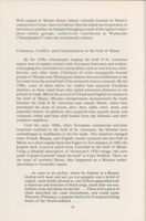
Commerce, Conflict, and Colonialization in the Gulf of Maine
By the 1530s, tribespeople ranging the Gulf of St. Lawrence
region were in regular contact with European fishermen and traders,
exchanging furs and hides for commodities such as steel knives, cloth,
biscuits, and other items. Chieftains of some strategically located
groups of Micmac and Montagnais Indians became middlemen in the
fur trade from the second half of the sixteenth century onwards. By the
1590s, some of these native fur traders had acquired European
shallops; in these small boats they sailed enormous distances in the
pursuit of trade. Before the arrival of French and English fur traders in
the Gulf of Maine, Micmac entrepreneurs monopolized the trade
between the Gulf of St. Lawrence and coastal Maine, where they
purchased the skins of moose, deer, bear, sable, otter, mink, and
especially beaver. In addition, they acquired corn, squash, beans, and
wampum (white and blue shell beads) from the Abenaki and their
southern neighbors.
Until the early 1600s, when European commercial activities
remained confined to the Gulf of St. Lawrence, the Micmac were
unchallenged as middlemen in the fur trade. This situation changed
when French, Basque, and English vessels ventured into the Gulf of
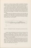
Maine on a more regular basis (see Figure For instance, in 1602, the
English bark Concord sailed from Cornwall to the Gulf of Maine.
Using a detailed description of Verrazano's 1524 voyage, the crew
under Captain Gosnold "made the land" at Cape Neddick. There, on
the coast of southern Maine, they happened on a Micmac trader.
According to Gosnold's report,
we came to an anchor, where six Indians in a Basque
shallop with mast and sail, an iron grapple, and a kettle of
copper, came boldly aboard us, one of them apparelled with
a waistcoat and breeches of black serge, made after our sea-
fashion, hose and shoes on his feet
These with a piece of
chalk described the coast thereabouts, and could name
Placentia (Plaisance, a popular harbor for European fishing
fleets) of the Newfoundland
26
Et ait Helias Reuertere et africe Septem vicibus, et factum cst in Septima ct cccc nubes parna oves fendchat
Adam Willeres Inuenter
Magdalena Van de pas fecit
pas
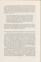
Figure 2 - This engraving of Basque whalers shows a number of vessel types
popular during the seventeenth century. The smaller boat in the foreground
may be a shallop, often equipped with both sail and oars. The larger vessels
are probably carracks, typical trading vessels of the fourteenth through
seventeenth centuries. Ships of this type were probably used by the early
explorers and would have become a familiar sight to native people on the
coast. Photo courtesy The Kendall Whaling Museum, Sharon,
Massachusetts, USA, P-S114.
27
In 1604, two French vessels arrived in the Gulf of Maine. The
expedition's navigator, Samuel de Champlain, scouted the area for a
suitable place to locate a new colony and fur trade post, and initially
established one on an island in Passamaquoddy Bay. Guided by two
local Indians, a Micmac and a Maliseet, Champlain and twelve
crewmen boarded a pinnace to explore the coast. On September 5,
Champlain noted in his log:
we passed also near to an island about four or five
leagues long, in the neighborhood of which we just escaped
being lost on a little rock on a level with the water, which
made an opening in our barque near the keel. [This island]
is very high and notched in places, SO that there is the
appearance to one at sea, as of seven or eight mountains
extending along near each other. The summit of most of
them is destitute of trees, as there are only rocks on them
I named it Isle de Monts Deserts.
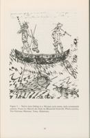
The Indian name for Mount Desert Island was Pemetiq, meaning "a
range of mountains." They encountered some canoes in the Mount
Desert Island area, manned by Indians who "had come to hunt beaver,
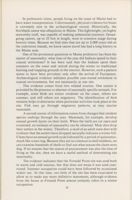
and to catch fish, some of which they gave us" (see Figure 3).
Champlain reported that these people "guided us into their river
Peimtegoet [Penobscot], as they call it, where they told us lived their
great Captain named Bessabez, headman of that river.' Observing that
it "was the first time they had ever beheld [European] Christians,"
Champlain referred to these natives as Etchemins (Maliseet-
Passamaquoddy) and described them as "very swarthy and
clothed
in beaver-skins and other furs."
Searching for the legendary city of Norumbega, Champlain
steered his small vessel far up the Penobscot. Finding no evidence of
this place, he reported seeing
only one or two empty Indians cabins which were
constructed in the same manner as those of the Souriquois
[Micmac], which are covered with tree-bark; and from what
I could judge there are few Indians in this river, which is
called Pemetegoit [Penobscot]. They come there and to the
islands for only a few months in summer during the fishing
and hunting season when game is plentiful. They are a
people
with no fixed abode; for they winter now in one
place, now in another, wherever they perceive that the chase
for wild animals is the best.
28
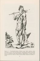
Figure 3 - Native men fishing in a Micmac-style canoe, early seventeenth
century. From Les Raretes des Indes by Becard de Granville. Photo courtesy
The Gilcrease Museum, Tulsa, Oklahoma.
29
The Etchemin chieftain Bessabez, or, as the English referred to him,
the Bashaba, was the powerful sagamore (headman) of about 250
warriors. Politically allied to neighboring sagamores, each of whom
had their own followings, Bessabez was able to muster the support of
many hundreds of fighters. However, he "had many enemies,
especially those to the east and northeast, whom they called Tarantines
[Micmacs, who were] counted a
warlike and hardy people."
The following year, the French colonists, under the Sieur de Monts,
relocated their settlement across the Bay of Fundy, at Port Royal,
while Champlain continued to explore and map the coastal region as
far south as Cape Cod. That same year, five Etchemin were kidnapped
from Pemaquid by an English crew under the command of Captain
Weymouth, who shipped them back to England. They eventually came
into the custody of an entrepreneur named Lord Ferdinando Gorges,
who kept them for several years, and "made them able to set me down
what great rivers ran up into the land, what men of note were seated on
them, what power they were of, how allied, what enemies they had, and
the like
" The captives, Dehanada, Skidwarres, Assacomet,
Maneddo, and Amoret said they came from Mawooshen, a territory
"governed in chief by a principali commander or prince, whom they
call Bashaba [of Penobscot], who hath under his divers petty kings,
which they call sagamores,
all rich in divers kinds of excellent furs."
When Armouchiquois tribesmen from the Saco River murdered a
Micmac trader at Penobscot Bay, Membertou, the Micmac sagamore
at Port Royal, assembled a fighting force of Micmac and Maliseet
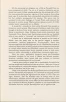
allies to revenge his kinsmen (see Figure 4). In the summer of 1607,
armed with spears, tomahawks, bows and arrows, as well as with
muskets, the warriors sailed in shallops to the Saco, where they
attacked the Armouchiquois. It appears that their French allies had
supplied them with the firearms when the French, including
Champlain, temporarily vacated Port Royal, returning to France to
settle some legal disputes about Sieur de Monts' title to the fisheries
and fur trade in Acadia.
Meanwhile, two English vessels, guided by Skidwarres and
Dahanada (two of Weymouth's kidnapped tribesmen), arrived at the
mouth of the Kennebec in 1607, founding the Popham colony.
According to the region's natives their Spirit, Tanto, "commanded
them [the Indians] not to dwell neere, or come among the English,
threatening to kill some and inflict sickness on others, beginning with
two of their Sagamo[re]s children." Unsuccessfully settled by a group
of "convicted felons," the Popham colony was abandoned in 1608.
30
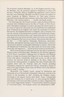
marvelled at native dress and decoration, including here tattoos and what
Figure
4 - Seventeenth-century Micmac man. Early explorers often
may be a wampum or glass bead headdress. Engraving by J. Laroque, after
Jacques Grasset St. Sauveur. Photo courtesy Public Archives of Canada, C-
21112.
31
The following year, the Dutch vessel De Halve Maen (The Half
Moon) under Captain Henry Hudson arrived in the Gulf of Maine. En
route to the Penobscot River, he and his crew spotted several French
fishing vessels and two sailing boats manned by Micmac. The Indians
informed Hudson that "the Frenchmen doe trade with them; which is
very likely, for one of them spoke some words of French." Landing at
Penobscot, they saw
two French shallops full of the country people [Indians]
come into the harbour, but they offered us no wrong, seeing
we stood upon our guard. They brought many beaver
skinnes and other fine furres, which they would have
changed for redde gowns. For the French trade with them
for red cassockes [coats], knives, hatchets, copper kettles,
trevits [?], beades, and other trifles.
After five days of trade Hudson's men switched their tactics to force,
driving the natives from their houses and seizing the furs they wanted.
Leaving the Penobscot behind, the Dutch sailed for the Hudson River,
named after De Halve Maen's savage captain.
The Founding and Fall of the Jesuit Mission at Mount Desert Island
By this time, crews from several French and English vessels were
employed in fishing and fur trade activities all along the coast, called
Acadia by the French. Concerned about the increased competition for
beaver and other furs in the Gulf of Maine area, a party of about
twenty French colonists returned to Port Royal in 1610. For three
years, the abandoned establishment had been guarded by Chief
Membertou and the Micmac. In addition to the Sieur de Poutrincourt,
their commander, and his son de Biencourt, the community at Port
Royal included secular priest Jesse Fleché, who immediately began to
baptize the local Micmac, although "he did not know the language,
and had nothing with which to support them."
In May 1611, after four months at sea, two Jesuit Fathers, Pierre
Biard and Enemond Massé, arrived in Port Royal on board La Grace
de Dieu. They were sponsored by the powerful Marquise de
Guercheville, wife of the Governor of Paris and lady-in-waiting to the
Queen Mother, Marie de Medici. During the summer, Biard
accompanied Biencourt on several trips, "the one lasting about twelve
days, the other a month and a half; and we have ranged the entire coast
from Port Royal to Kinibequi [Kennebec]
We entered the great
32
rivers St. John, Saincte Croix, Pentegoet [Penobscot], and the above-
named Kinibequi
We visited the French who have wintered there
this year in two places, at the St. John River and at the river Saincte
Croix." During his journey to Penobscot River, Biard visited
Bessabez's village:
"
there was the finest assemblage of Indians that I
have yet seen. There were 80 canoes and a shallop, 18 lodges and about
300 souls."
In exchange for furs, the region's tribespeople acquired all kinds
of European commodities, such as steel knives, hatchets, copper
kettles, alcohol, and cloth, among other things. The impact of the fur
trade on Wabanaki life was quite obvious, as Biard noted: "
in
Summer they often wear our capes, and in Winter our bed-blankets,
which they improve with trimming and wear double. They are also
quite willing to make use of our hats, shoes, caps, woolens and shirts,
and of our linen to clean their infants, for we trade them all these
commodities for their furs."
From Port Royal, Biard mailed detailed reports to his superiors
in Paris, describing the conditions in Acadia, its native peoples, their
way of life, and, of course, the commercial opportunities of the fur
trade and the fisheries. Commenting on his mission to the Indians, the
Jesuit wrote:
If they are savages, it is to domesticate and civilize them that
we have come here; if they are rude, that is no reason that we
should be idle; if they have until now profited little, it is no
wonder, for it would be too much to expect fruit from this
grafting, and to demand reason and beard [maturity] from a
child.
On the other hand, the Jesuit was quite aware how the region's
Wabanaki viewed the Europeans on their shores:
[They] conclude generally that they are superior to all
Christians
Also they consider themselves more
ingenious, inasmuch as they see us admire some of their
productions as the work of people SO rude and ignorant;
lacking intelligence, they bestow very little admiration upon
what we show them, although much more worthy of being
admired. Hence they regard themselves as much richer than
we are, although they are poor and wretched in the extreme
They consider themselves better than the French: 'For,
they say, 'you are always fighting and quarreling among
33
yourselves; we live peaceably. You are envious and are all
the time slandering each other; you are thieves and
deceivers; you are covetous, and are neither generous nor
kind; as for us, if we have a morsel of bread we share it with
our neighbor, they are saying these and like things
continually
Supported by the Queen Mother, influential Jesuits in Paris
induced Madame de Guercheville to form a new French colony in
Acadia. Having acquired a grant from King Louis XIII, she possessed
a monopoly on the fur trade in the Gulf of Maine. Madame de
Guercheville appointed the Sieur de la Motte as its commander,
instructing him to have a vessel fitted out for the expedition to the Gulf
of Maine. About fifty Frenchmen, including two Jesuit brothers,
Gilbert du Thet and Quentin, boarded the ship, which left France in
January 1613. Landing at Port Royal, they were joined by Biard and
Massé. Using Champlain's maps, and probably guided by Biard, who
was familiar with the area as far south as the Kennebec, the vessel
sailed toward Penobscot Bay. Arriving on the eastside of Mount
Desert Island, the vessel anchored in a harbor.
At Mount Desert Island, "a great crowd of savages" came to see
the French, bringing a sick child to Biard. Healed by the Jesuit, the
child was baptized and given the name of its new godfather, Nicholas
de la Motte. Hearing that the French "had some intention of making a
settlement there," Bessabez of Penobscot "came to persuade us, with a
thousand promises, to go to his place" at Kadesquit (now Bangor).
Instead, invited by local tribespeople to remain at Mount Desert
Island, the French began to build their settlement named Saint
Sauveur-"Holy Savior." Operating from their new headquarters at
Saint Sauveur, the Jesuits planned to embark upon their missionary
activities.
The Wabanaki tradition as told by the Penobscot chieftain
Joseph Nicolar relates these events as follows:
At about this period another white man came in his big
canoe and landed on the shore of the eastern coast almost in
the midst of the northern country, on a high island very near
the spot where [Gluskap] and the dog killed the first moose.
Here the white man planted his cross.
34
The Tears That Rush Upon My Brow
Disputing French political claims to Wabanaki territories, the
English colonists at Jamestown argued that the Gulf of Maine
belonged to Virginia. Realizing that their rivals had founded a new
settlement at Mount Desert Island, the English feared competition.
That same summer, Captain Argall of Jamestown received orders to
attack the Mission of Saint Sauveur, and surprised the infant colony.
Thirty-five Frenchmen were captured, and the Jesuit du Thet was
killed. Father Massé and thirty others were allowed to take two
shallops and leave the island. After a difficult journey, they were
rescued by fishing vessels, which took the hapless colonists back to
France. The Jesuits Biard and Quentin, as well as two other
Frenchmen, were taken to an English vessel off Pemaquid, which
carried them back to Europe. Meanwhile, Captain Argall received
instructions "to plunder and demolish all the fortifications and
settlements of the French
along the entire coast as far as Cape
Breton." Having razed Saint Sauveur, the English captured an Indian
at Passamaquoddy Bay. He showed them the way to Port Royal,
which they burned to the ground.
Meanwhile, still supplied by their French allies, Micmac
(Souriquois) warriors tried to maintain their dominant trading
position northeast of the Penobscot. From their Gulf of Maine
stronghold at Mount Desert Island, by then also known as Sourico
Island, sailing in shallops and armed with muskets, they could stage
lightning raids against their enemies, in particular the Bashaba of
Penobscot. In 1615, according to an English document, they
"surprised the Bashaba, and slew him and all his people near about
him, carrying away his women and such other matters as they thought
of value." A year later, this intertribal war on Maine's coast was
followed by "a great and general plague, which SO violently reigned for
three years together, that in a manner the greater part of that land was
left desert, without any to disturb or oppose our free and peaceable
possession thereof."
Because they were unfamiliar with the alien diseases introduced
by the newcomers from across the Atlantic, most Wabanaki victim
to highly contagious diseases such as smallpox and bubonic plague.
An estimated seventy-five percent of the native population, and
perhaps even more, perished during this epidemic. When it was over,
an Englishman wrote "that they died on heapes as they lay in their
houses and the living that were able to shift for themselves would
runne away, & let them dy
And the bones, and skulls
made such
35
a spectacle that as I travailed in that Forrest
it seemed to mee a new
Golgotha."
In the nineteenth century, still remembering this accursed period
in their people's history, old Penobscot Indian traditionalists
recounted the words spoken by the old man when he reported seeing
the "strange tracks" on the beach. Back in his village, he told the tribal
council of elders:
Upon seeing the strange tracks, all the warnings which have
been giving us, how that a time is coming when we must look
for the coming of the white man from the direction of the
rising sun
I could not withhold the tears that rushed
upon my brow. Knowing that a great change must follow his
coming it made me weak and the weakness overcame me,
because his coming will put a bar to our happiness, and our
destiny will be at the mercy of the events. Being satisfied that
me and the young men have seen the tracks of this strange
man, it becomes as our gravest duty to prepare ourselves
and people SO to be ready to meet the changes which may
follow.
36
Bibliography
Anon., The Description of the Countrey of Mawooshen, in: S.
Purchas, Hakluytus Posthumus or Purchas His Pilgrimes
Contayning a History of the World in Sea Voyages and Lande
Travells by Englishmen and others, Vol. XIX, Glasgow, James
MacLehose and Sons, University Press, 1907.
Archer, G., The Relation of Captain Gosnold's Voyage to the North
Part of Virginia (1602), in Massachusetts Historical Society
Collections Third Series, Vol. 8 (1843) pp. 72-81.
Asher, G.M., Henry Hudson the Navigator, London, 1860.
Bakker, P., Trade Languages in the Strait of Belle Isle, Paper read at
Labrador Conference on cross-cultural contact in Strait of Belle
Isle, Oct. 1988 [n.p.].
Biard, P., in Thwaites, ed., The Jesuit Relations, Vols. 1,2,3,4.
Biggar, H.P., The Voyages of Jacques Cartier, Public Archives of
Canada, Ottawa, 1924.
Brereton, J., A Brief and True Relation of the Discovery of the North
Virginia, etc., made this present year 1602, by Captain B.
Gosnold, Capt. B. Gilbert, etc., by the Permission of the Hon.
Knight Sir W. Raleigh, London 1602, in Mass. Hist. Soc.
Collections, 3rd Series, Vol. 8, pp. 83-123.
Burrage, H.S., Gorges and the Grant of the Province of Maine 1622, a
Tercentenary Memorial, Augusta, 1923.
Burrage, H.S., ed., Rosier's Relation of Weymouth's Voyage to the
Coast of Maine, 1605, with an introduction and notes, Portland,
1887.
Champlain, S. de, Works, (edited by H.P. Biggar), 6 vols., The
Champlain Society, Toronto, 1922-1936.
Charlevoix, P.F.X. de, History and General Description of New
France, New York: F.P. Harper, 1900 (translated with
annotations by J.G. Shea), 6 vols.
DeCosta, B.F., Gosnold and Pring 1602-1603, in New England
Historical and Geneological Register, Vol. 32 (1878):76-80.
Eckstorm, Fannie H., Indian Place Names of the Penobscot Valley
and the Maine Coast (1941), University of Maine at Orono Press,
1978.
Gorges, Ferdinando, A Briefe Narration of the Originall Undertakings
of the Advancement of Plantations into the Parts of America,
Especially, shewing the Beginning, Progress and Continuance of
that of New-England (1658), in: Collections of the Massachusetts
Historical Society, 3rd Series, Vol. 5: 45-93.
Hakluyt, R., The Principall Navigations, Voiages and Discoveries of
the English Nation, (1589-1601).
Hakluyt's Voyages, Selected and edited by R. David, Boston:
Houghton Miflin Company, 1981.
Hamilton, M.W., Henry Hudson and the Dutch in New York, Albany,
1964.
Hoffman, B.G., Cabot to Cartier, Sources for a Historical
Ethnography of Northeastern North America 1497-1550,
Toronto, 1961.
Kennedy, J.H., Jesuit and Savage in New France, New Haven, 1950.
Leger, M.C., The Catholic Indian Missions of Maine, 1611-1820,
Studies in American Church History, Vol. 8, Washington, DC,
1929.
Lescarbot, M., The History of New France, (edited by H.P. Biggar),
3 vols., Publications of the Champlain Society, Toronto, 1911-
1914.
Mitchell, D., The Jesuits, a History, New York, 1981.
Morison, S.E., The European Discovery of America, Vol. 1, Northern
Voyages, New York: Oxford University Press, 1971.
Morison, S.E., The European Discovery of America, Vol. 2, The
Southern Voyages, New York: Oxford University Press, 1974.
Murdoch, B., A History of Nova Scotia, Halifax, 1865, (3 vols.).
Nicolar, Joseph, The Life and Traditions of the Red Man, Bangor:
C.H. Glass, 1893, (reprinted, with a new introduction by J.D.
Wherry, by Saint Annes Point Press, Fredericton, 1979.
Reid, John G., Acadia, Maine, and New Scotland, marginal colonies
in the seventeenth century, Toronto, 1981.
Sauer, C.O., Sixteenth Century Norh America, The Land and People
as seen by the Europeans, Berkeley, 1972.
Sauer, C.O., Seventeenth Century North America, Berkeley, 1980.
Smith, John, A Description of New England, London 1616, in:
American Colonial Tracts Monthly, Vol. II, No. 1 (May 1898),
Vol. 2: 1-39.
Smith, John, New England's Trials, London 1622, in Ibid., Vol. II, No.
2 (June 1898): 1-23.
Thayer, H.O., The Sagadahock Colony, Portland, 1892.
Thwaites, R.G., ed., The Jesuit Relations and Allied Documents,
Travels, explorations and missions of the Jesuit missionaries in
New France, 1610-1791 (73 vols.), Cleveland, 1896-1901.
Wright, L.B., ed., The Elizabethan's America: A Collection of Early
Reports by Englishmen on the New World, Cambridge, 1965.

