
From collection Place

Related Items
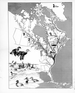
Migration of Birds, Atlantic Flyway
8 X 10 black and white photograph of a graphic drawn by Bob Hines showing migration of birds. Drawing by Robert Hines (Atlantic Flyway) . April 1962, FrontiersCredit Florida Fish and Wildlife Commission.
Early American Homes
Contains information on the Thomas Ruggles Home
Painting of Chevy Chase, MD
A panoramic painting of Chevy Chase township in Maryland.
Heron and Egret Population of Sandy Hook, NJ
Surveys local heron and egret populations at Sandy Hook, NJ, comparing personal observational data with EBird citizen science data to analyze trends. This project is in ESRI GIS Story Map format.
Our Own Snug Fireplace
It is about the reality and reminiscence in everyday life in New England during the years 1760-1860.
Early American Homes
October 1999. Coastal homes, mustard recipes, redware, etc.
Archaeological Sites Near Michigan's Great Lakes: What We Can Learn From Ancient Artifacts
This project explores archaeological sites throughout Michigan, focusing on artifacts left by early inhabitants after glacial retreat. Using GIS analysis, it maps locations of significant finds and examines the historical and environmental…
Early American Homes
On page 46 article on the Fisher House
Supplement to the Biographical Sketch of the Rev. Jonathan Fisher
Gray cover with title in black print. 24 pages

