Acadia Maritime Cultural Resources Inventory Final Report
Acadia Maritime Cultural Resources Inventory
Final Report
Funded by an LL Bean Acadia Research Fellowship
Submitted January 2009
By
Franklin H. Price, Joshua Daniel, Kristen Chasse, and John Stallings
ii
TABLE OF CONTENTS
TABLE OF CONTENTS
ii
EXECUTIVE SUMMARY
iv
INTRODUCTION
1
METHODOLOGY
2
GIS Methodology
3
Research Methodology
3
Archival Research
4
Historical Sources
5
Online Sources
6
Previous Archeological Research
7
Interviews
8
Shoreline Survey
8
LIMITATIONS
8
RESULTS
9
SENSITIVITY AREAS
10
Sand Beach
11
Baker Island
11
Long Ledge
13
Bar Island
15
Schoodic Point and Schoodic Island
15
Otter Point
16
Isle au Haut
16
Bald Porcupine Island
17
Bear Island
17
Eagle Lake
17
Prehistoric Areas
18
FURTHER RECOMMENDED HISTORICAL RESEARCH
18
RECOMMENDED PROJECTS
20
CONCLUSION
22
ACKNOWLEDGEMENTS
23
APPENDIX A: REFERENCES CITED
24
APPENDIX B: HISTORICAL DATA
36
APPENDIX C: INTERVIEW DATA
44
APPENDIX D: ARCHEOLOGICALLY CORROBORATED SITES 2006-2008
45
APPENDIX E: LIST OF INVESTIGATED STORMS
46
APPENDIX F: KEYWORDS SEARCHED ON NEWSPAPERARCHIVES.COM
47
APPENDIX G: FIELD INVESTIGATIONS ON PARK LANDS
48
Lobster Trap at Otter Cliff
48
Wreckage at Radio Cove
48
APPENDIX H: TOWNSHIPS INVESTIGATED
50
APPENDIX I: 2008 DOWNEAST MARITIME INTERVIEW PROJECT
51
Introduction
51
Methods
51
Results
53
iii
Interview of Charlene Allen
54
Interview of Prescott Briggs
56
Interview of Sheldon Goldthwait
57
Interview of "Brud" Lawson
59
Interview of Tony Menzietti
60
Interview of Janet Patten
62
Interview of Mike Pinkham
63
Interview of P.J. Presnell
65
Interview of Dana Rice
67
Interview of Ralph Stanley
71
Interview of "Buddy" Trundy
73
Interview of Phil Whitney
75
PRIMARY AUTHOR BIO
76
iv
EXECUTIVE SUMMARY
In 2008 an LL Bean Acadia research Fellowship funded the Acadia Maritime
Cultural Resources Inventory, a brief overview and assessment project reviewing
instances of maritime disaster and vessel abandonment near Acadia National Park. This
report provides a synopsis of known wrecks, a GIS database with geospatial information,
and a sensitivity model of likely areas where maritime cultural resources might be found.
It also includes the results of modest field interviews of local informants, as well as
known wreck sites corroborated by the authors. This report highlights geographic areas of
potential sensitivity and suggests what further work could be undertaken to enhance our
knowledge of the subject. Although of limited scope, it opens a window into the
possibilities for study that these shipwrecks provide. The wealth of material, the diversity
of the sources, and the centuries of history involved illustrate the great potential that this
resource has for education, archeology, and research.
INTRODUCTION
The Acadia Maritime Cultural Resources Inventory was funded by the LL Bean Acadia
Research Fellowship Program. The primary research objective of the project was to use
the historic record to determine what vessels wrecked near or in Acadia National Park
(hereafter referred to as the Park) and to provide a brief overview and assessment of these
resources. The project also incorporates modest archeological and interview work to
present a picture of potential maritime cultural resources in the subject area. The
historical and archeological information synthesized in this report may act as a sensitivity
model for management by providing areas where the historical record indicates the
potential presence of maritime cultural resources. The maritime information is interpreted
geospatially through the use of a Geographic Information System (GIS), incorporating
geographical and historical data.
This work is the first stage in what could be a far more comprehensive study, a
modest glimpse into a rich resource. It highlights geographic areas of potential sensitivity
and suggests what further work could be undertaken to enhance our knowledge of the
subject. Although of limited scope, it opens a window into the possibilities for study that
these shipwrecks provide. This topic has great potential for sparking public interest, and
could be an excellent educational tool to teach about history, the maritime world,
seafaring, links between climate change and sea level rise, and a host of other topics in
science and the humanities.
The report's subject matter are any vessels known to have been lost in the area
whether via discard or shipwreck. The vast preponderance of vessels listed in this report
were lost in wrecking events, a notable difference from many other regions where a
substantial number of vessels meet their demise as abandoned watercraft (Shomette and
Eshelman 1998:332-333; Richards 2002).
Geographically the study area is bound by Isle au Haut to the west and Prospect
Harbor to the east, covering 21 townships and all of Acadia National Park (Figure 1).
Any wrecking events that apparently lead to the loss of a vessel were reported in this
work, including vessels outside of Park lands but within the study area. In this respect the
report is actually an inventory of known wrecks within a specific geographic area. Many
of the wrecks included in this report were researched during the primary author's
Bar Harbor
Schoodic Peninsula
Bass Harbor
Southwest Harbor
N
5 2.5 0
5 Kilometers
Isle au Haut
Legend
Park Boundaries
Figure 1. Study Area (Image Joshua Daniel).
2
previous historical work. Information regarding wrecks near or on Mount Desert Rock is
also included.
METHODOLOGY
The data is divided into three types, all of which contributed to the synthesis of
the report. The historical record provided the first category, the archeological record
another, and as yet un-corroborated information from local interviewees constitutes a
third. Each of the three groups was given its own geo-referenced GIS file, and each is
submitted with the report.
Historical research was the primary focus of the project, the interview and field
sections were additions meant to complement this material. Secondary historical sources
included wreck lists, local and regional histories, and other works. Newspapers were the
most productive of the primary source materials, but Captain's Protests and US
Lifesaving Station correspondence also furnished first-hand accounts. Historical sources
provided data on 155 vessels. This information is provided as Appendix B: Historical
Data. Plotted geographically, the information shows shipwrecks scattered throughout the
study area (Figure 2). The sources used in the historical database are included in the
References Cited section for the entire report (Appendix A: References Cited).
As a supplement to the historical research, investigators interviewed local
informants during the summer of 2008. Taken as a whole, a local population in a coastal
area often possesses a vast knowledge of its maritime cultural resources (Price 2008a;
Westerdahl 2006, 2008). The team gathered information regarding area wrecks, focusing
upon an area under-reported during previous survey work, the east side of Frenchman
Bay and Schoodic Peninsula (Figure 3; Appendix C: Interview Data).
Archeological research regarding nautical material within or near the park is
scanty. Surveys by Crane and Morrison documented some debris, but overall little work
has been done regarding maritime cultural resources (Crane and Morrison 2001:34, 42-
43; Crane and Morrison 2003:18-19; Wright et al 2004:283). During summer 2008 the
author visited the site of reported wreckage, potentially of a maritime nature, at Seawall,
and also visited intertidal wrecks outside Park boundaries at Great Cranberry Island, and
in Hancock. These visits had the sole purpose of corroborating the presence of
archeological material. All corroborated sites or material revealed during the course of
N
9
4.5
0
9 Kilometers
Legend
Park Boundaries
Historic Wreck Sites
Figure 2. Wreck Sites from Historical Sources (Image Joshua Daniel).
N
4 2
0
4 Kilometers
Legend
Park Boundaries
2008 Interview Sites
Figure 3. Sites as Reported by Informants, 2008 (Image Joshua Daniel).
3
maritime interviews 2006-2008, including previous work undertaken by the primary
author, is included as Appendix D: Archeologically Corroborated Sites 2006-2008
(Figure 4).
GIS Methodology
With information collected in the field, a Geographic Information System (GIS)
was developed to aid in the organization and visual interpretation of the data. The first
objective was to create the geo-referenced base map that would be the foundation of the
Acadia National Park GIS. To simplify field research and maintain compatibility
between coordinate systems, the decision was made to use geographic coordinates
(latitude and longitude) for the base map projection and subsequent site location
identification. Latitude and longitude coordinates in this report are in WGS 1984 datum.
All digital data is referenced to UTM Zone 19, NAD 83.
Vector base map data depicting political borders (state, county, parks, and
reserves), open water, lakes, and streams were obtained from the Maine Office of GIS
(http://megis.maine.gov/) and the National Park Service Data Store
(http://science.nature.nps.gov/nrdata/index.cfm) These features were supplied in the
form of georeferenced shapefiles.
Maps and coordinates from historic data and personal interviews were used to
supply the geographic coordinates for the database. The information for each wreck or
cultural feature is entered into a shapefile and is represented on the map by a symbol. By
selecting these symbols, the user can access database information including home ports,
informant names, site periods, a brief description of the site/artifact, latitude and
longitude, and the accuracy of the information. Metadata for each shapefile is also
included with the final copy of the report.
Research Methodology
The research methodology was primarily to employ the historic record to find
evidence of shipwrecks, but archeological evidence and local interviews assisted in
providing a picture of what vessels have been lost in the vicinity of the Park. Despite the
contributions of lines of inquiry using interviews and modest archeological
reconnaissance, historical sources, both archival and online, supplied the vast
preponderance of the information submitted in this report.
N
5 2.5 0
5 Kilometers
Legend
Archeologically Corroborated Sites and Artifacts
Park Boundaries
Figure 4. Archeologically Corroborated Sites 2006-2008 (Image Joshua Daniel).
4
Archival Research
Researchers visited the historical societies of Bar Harbor, Ellsworth, Stonington,
and Great Cranberry Island to gather information. As part of previous research
investigators visited historical societies of Tremont, Southwest Harbor, Mount Desert
Island, and Blue Hill. The historical societies of Sorrento/Sullivan and Islesford were also
contacted and may hold valuable information. Acadia National Park's William Otis
Sawtelle Collections and Research Center furnished several primary source documents
documenting local wrecking events.
Research in public libraries at Southwest Harbor, Northeast Harbor, Ellsworth,
and Sorrento, as well as Bar Harbor's Jesup Memorial Library produced material on
numerous wrecks. During the previous summer the primary author visited the Blue Hill
and Winter Harbor Public Libraries. Jesup Memorial Library in Bar Harbor kindly
provided the project with several useful historic images from their collections. Maritime
material from the Fogler Library at the University of Maine at Orono, including its
Special Collections, also added to this report.
Investigators contacted numerous organizations, most notably museums,
historical societies, the Maine Bureau of Parks and Lands, and the United States Coast
Guard (USCG). The USCG Southwest Harbor and the USCG Historian's Office in
Washington, DC, did not have shipwreck lists available. The National Oceanic and
Atmospheric Administration's (NOAA) Automated Wreck and Obstruction Information
System (AWOIS) is a list of "reported wrecks and obstructions" that includes information
within the Park area (National Oceanic and Atmospheric Administration 2006:3). This
compilation contains the location of a very limited amount of wrecks near the coast of
Downeast Maine, none of them on park lands.
Investigators contacted the historian for the Maine Bureau of Parks and Lands and
discussed potential avenues for wreck research. Historian Tom Desjardins provided
information on area wrecks and lore. This information is likely the extent of the Bureau's
holdings on the Park region regarding submerged cultural resources.
Contact with the National Archives and Records Administration, Northeast
Region at Boston revealed a collection of primary source documents regarding the
5
activities of the Life Saving Stations at Frenchman Bay and Little Cranberry Island in the
research area. Time did not allow a research field trip to Boston, where these documents
are housed.
Local, state and regional museums did not have special compendiums or lists of
shipwreck information that could assist in identifying or locating potential sites. The
Great Harbor Maritime Museum in Northeast Harbor did not respond to our inquiries.
Staff at the Maine Maritime Museum in Bath was of the opinion that a day trip was not
necessary unless its purpose was to gather information on specific Maine vessels. The
Searsport, Maine, Penobscot Marine Museum has information regarding specific vessels,
but does not have a wreck list of vessels from the area in question. The Mystic Seaport
Museum in Mystic, Connecticut, has shipping registries post-1900, but these are not
available online like its nineteenth century registries. It also has an extensive maritime
collection, and might merit a visit as part of future research. The latter three museums
would be prime locations for research involving specific vessels.
Historical Sources
Secondary sources such as historic maps, shipwreck compilations and histories
yielded numerous wreck names and locations. Most of these were corroborated through
consulting shipping lists and newspaper reports. The publication Merchant Vessels of the
United States, 1908-1978, and 1981 contained a wealth of information regarding wrecks
in the subject area. Primary sources included Captain's Protests, receipts, and
correspondence, but contemporary newspapers were the most fruitful source of
information on maritime disasters.
Investigators reviewed microfilm versions of the Ellsworth American, Ellsworth
Easterner, and Ellsworth Herald newspapers from the 1850s through 1869 in their
Marine Journal, Marine List, and similar sections. These headings list maritime disasters
on the local, national, and international levels. One weakness to using these sections is
that local wrecks are sometimes reported as paragraphs in state, county, or town
happenings, and unless each newspaper were read in its entirety, certain nautical
accidents are bound to be missed. Microfilmed copies of the Bar Harbor Record, Bar
Harbor Times, and Mount Desert Herald have been searched in marine news sections
6
from the 1880s to January 24, 1907. Other newspapers were accessed digitally using
keywords and search engines. They are covered in the online sources section below.
Within the microfilm records of the Bar Harbor Record, Bar Harbor Times, and
Bar Harbor Herald at Jesup Memorial Library investigators searched for specific vessels
and dates with some success. The following vessels with year of loss, however, were
absent from the newspaper records: Agnes May 1907, Ara 1927, Arizona 1912, Avis
1905, Bonetta 1871, Greta 1911, North Star 1951, Oriole 1914, and Thomas 1913. These
vessels were compiled from a wreck list, the Northern Research Database, known to have
some inconsistencies in the reliability of its dating and referencing information (Northern
Maritime Research 2002). The wrecks of Ara and North Star were corroborated with
another source (Berman 1972). The absence of the above wrecks does not mean that the
information is necessarily erroneous, but that more research may be necessary to extricate
the facts from the historical record.
Using the dates of significant storms that struck the Maine coast provided the
identities of several shipwrecks. Reports of six wrecks were found in this manner by
obtaining storm dates from historic records or accounts of other wrecks and scouring the
newspapers from the same week as the reported storm. The wrecking events found in this
manner were as follows: Moby Dick and Constitution 1869, Ellson 1888, Vanelia, and
two un-named craft 1898. Investigators searched the Ellsworth American newspaper for
events surrounding 24 storms. For a complete list of storms searched see Appendix E.
Online Sources
Online, the National Oceanic and Atmospheric Administration (NOAA) has an
Automated Wreck and Obstruction Information System (AWOIS) available to the public.
This system has few wrecks and obstructions listed in the survey area. It is not
comprehensive, its focus is on obstructions to navigation and "wrecks which may be a
hazard to navigation" (National Oceanic and Atmospheric Administration 2006:3). It is
recommended that this information be integrated into the data base. NOAA also has
online information regarding historic storms that would be valuable to shipwreck
researchers at the following website: www.nhc.noaa.gov/HAW@/english/history.shtml
Some of the information listed on their website provided this report with the storm dates
researched in local newspapers.
7
The Mystic Seaport Museum has a digitized collection of vessel registries,
American Lloyds to 1900 and the American Bureau of Shipping to 1900 that proved
valuable in providing information regarding nineteenth century vessels, especially
dimensions, rig, and other particulars. Each of the vessels found in newspaper records but
not in other vessels lists can be checked against these registries. Researchers searched for,
but did not find, Union, Turk, Alice B. Dyer, Cygnet, Ava, JA Hines, Constitution, and
Moby Dick. Information regarding at least 33 area shipwrecks came from this source.
Newspaperarchives.com allowed researchers to search by time periods,
geographic locations and keywords. Investigators took advantage of the service at the
University of Maine's Fogler Library and searched geographic areas near the Park.
Specific wrecks from questionable sources were also searched for in an attempt to
corroborate their existence. Searches and key words are listed in Appendix F. On the
surface, this type of research appears spotty. Occasionally the exact same keywords will
produce different results. However, despite its limitations this approach located or
substantiated 10 wrecks within the survey area.
Previous Archeological Research
Very little previous archeological maritime research regarding shipwrecks has
been conducted in the vicinity of the Park. Park officials are aware of the remains of the
schooner Tay at Sand Beach, that Wauwinnet was scuttled in Eagle Lake, and that Grand
Design ran aground at Long Ledge, but concerted surveys at these three locations to
examine potential wreckage have not been conducted. A walkover of the Ship Harbor
area mentions "stone features" of interest, possibly connected with Grand Design, either
as shipwreck camp remains or graves (Wright 2004:48; citing Hornsby et al. 199:29).
Outside Park boundaries an archeological field school, run by Professional Association of
Diving Instructors (PADI) John and Marlene Daley, mapped a shipwreck identified as
Mabel E. Goss in Taunton Bay (Daley and Daley 2003). At Sorrento a survey discovered
likely wreckage on the shoreline (Crane and Morrison 2001:42). A field survey
corroborated the locations of vessel remains in Bass Harbor (Price 2008b). The paucity of
data suggests that substantial work is yet to be completed in the field.
8
Interviews
While modest in scope and number, interviews played an important role in this
project's ability to acquire archeological information. The team interviewed members of
the local populace, especially those engaged in commercial fishing, regarding the
location of submerged prehistoric artifact recovery areas and shipwreck sites. Ten
interviewees offered information on 20 potential shipwreck or abandonment sites,
anchors, and historic dump sites. An ongoing survey project interviewing fishermen and
divers in the Mount Desert Island area gathered information regarding the location of
maritime historic sites and inundated prehistoric sites (Price and Spiess 2007; Price 2007;
Price 2008b). The methodology attempted to broaden the research base from projects
completed in 2006 and 2007 by interviewing people outside of the immediate Mount
Desert Island area. For this reason, investigators interviewed individuals to the east of the
island, meeting with limited success. However, notable interviews at Prospect Harbor and
Sorrento provided useful information. For a list of 2008 interviews and their results, see
Appendix I.
Shoreline Survey
During June and July of 2008 researchers visited a few sites to corroborate the
existence of reported wreckage. Within the park itself, Seawall was the only area that
contained what may have been part of a vessel, although this is unlikely. A brief visit
revealed a section of debris over 18 feet in length and under two feet in width, deposited
to the landward side of the cobble beach. The primary author investigated this debris on 5
July 2008 (Figure 5). Large wire nails limited its potential age. For further information
see Appendix G. Investigators also observed vessel remains in June 2008 on the north of
Great Cranberry Island and on the Taunton River in Hancock, both outside of the Park
(Figures 6 and 7).
LIMITATIONS
The greatest limitations to the project were imposed by time and scope. As a brief
overview and assessment, the project was limited by its nature and purpose. Another
limitation was an occasional lack of available evidence to corroborate the historic and
archeological records. Some instances in the historic record were vague, some informant
reports were hearsay, and some archeological evidence is difficult to identify. It is often
Figure 5. Potential Wreckage at Radio Cove. Facing Northeast. 5 July 2008.
Figure 6. Abandoned Vessel, Great Cranberry Island. Facing East. June 2008.
Figure 7. Vessel at Hancock. Facing Northeast. June 2008.
9
difficult to match historical sources, informant reports, and the archeological record. At
times these three types of information will work in concert to produce a clear picture of
the history of maritime disaster in the area, but often the various sources do not
corroborate one another neatly.
As an example, David Farley of Bass Harbor reported finding a large anchor off
the southwest side of Long Island, Frenchboro, while scuba diving in sixty feet of water
(Price 2008b:13). In 1846 the steamer North America used her anchors while disabled in
a vain attempt to keep from stranding on the island during a strong South-Southwesterly
gale, although a terse report from Nova Scotia claims that she was lost at Isle au Haut
(Fond Du Lac Journal 1846; Nova Scotian 1846:3). The placement of the anchor
reported by Farley could be consisted with the story in the Fond Du Lac paper, although
it is at half the distance from shore. It could also have been an anchor from other reported
wrecks in the vicinity such as Ricochet or Union, or from another vessel entirely.
An example of this is the complexity the data surrounding the loss of Union.
According to local lore at Frenchboro, Union was lost on the southwestern shore of Long
Island (Price 2008b:27). A poem in the Acadia National Park's William Otis Sawtelle
Collection reports her as a brig and the place of loss as
"
three leagues from Mount
Desert's Rock" (Anonymous n.d.:1) Long Island fits this description. The poem
unfortunately was undated, and a date is absent in the local lore also. A beach on the
island bears the name of the vessel, and island residents attest that the wrecking event
took place well before they were born (Price 2008b:37). Several clues emerge from the
text of the poem. The first is that Union was lost on 9 February, three leagues, or eighteen
miles, from Mount Desert Rock, and that she was a brig from St. Johns, and that one
Atkinson "...lash'd himself unto the pump... " (Anonymous n.d.:1). If all of these facts
are true then there may be a way to find the year of loss using these clues. Shipping
records may provide answers, although American merchant vessel lists from the period
have thus far shed little light on the brig's identification Canadian sources might be more
helpful.
RESULTS
The wealth of material, the diversity of the sources, and the centuries of history
involved illustrate the great potential that this resource has for education, archeology, and
10
research. The survey uncovered substantial material from historical sources, archeology
and oral history. One hundred fifty vessels are included in the historical sources file, 40
of which were added to the database this summer. Twenty-one vessels are listed in the
archeologically corroborated file, 20 in the 2008 interview survey file. There is some
overlap with this material; future work should include an attempt to reconcile these
sources.
Of the 21 townships either wholly or partially covered in the survey area, the
Maine State Historic Preservation Commission (MHPC) has 204 files regarding wrecks, a
few of them apparently repeats of the same event (for a list of Townships see Appendix
H). The card file includes information from historical and archeological sources, as well
as data from local informants. The MHPC sites were not incorporated into the findings of
the project, but it is recommended that this step becomes an integral part of any further
research. Eighty-five vessels were not in the state's database, and of these 32 wrecks
previously unknown to the state were added during archival research.
SENSITIVITY AREAS
Given the wide range of maritime activities undertaken around the Park for
centuries, wreckage could potentially be found almost anywhere that the park bounds the
sea. However, a few specific areas merit special significance due to evidence from the
historic record. High sensitivity areas within or abutting park boundaries include Sand
Beach, Baker Island, Long Ledge, Schoodic Island, and Bar Island (Figure 8). Otter
Point, Isle au Haut, Schoodic Peninsula, Bald Porcupine Island, and Bear Island should
be considered medium sensitivity areas (Figure 9). High sensitivity areas are Park lands
abutting the ocean that have either known archeological material, or that have a high
numerical incidence of reported wrecks within a relatively small area. Medium sensitivity
areas are Park shores with reported wrecks, but in lesser frequency per area than in the
high sensitivity areas. Despite classification, all park shorelines could contain maritime
cultural resources either currently or after storms. It also should be noted that numerous
wrecks have very broad areas given for their loss, opening up the possibility that many of
these vessels could have left remains within park boundaries.
Site formation processes need to be considered when assessing the likelihood of
any vessel remains at the sensitivity areas. The wildly destructive nature of the ocean
Bar Island
Sand Beach
Schoodic
Island
N
Baker Island
2.5 1.25 0
2.5 Kilometers
Legend
Long Ledge
Park Boundaries
High Sensitivity
Figure 8. High Sensitivity Areas (Image Joshua Daniel).
Bald
Porcupine
Island
Schoodic
Peninsula
Otter Point
Bear Island
N
5 2.5 0
5 Kilometers
Isle au Haut
Legend
Park Boundaries
Moderate Sensitivity
Figure 9. Moderate Sensitivity Areas (Image Joshua Daniel).
11
along this rocky coast could easily batter a wreck and sweep away the pieces. In the face
of these forces some larger artifacts are less likely than others to move very far, for
example iron or steel machinery, anchors, and other large heavy objects. Artifacts may
also find their way into pockets either within cracks in rock or between rocks, and be
trapped there for long periods of time. Irish maritime archeologists have noted that rocky
areas can "provide protective niches for artifacts protecting them from the elements"
(Calahan et al. 2007:37). The submerged lands around the park abound in such
topography. As an example, the rocky parts of the coast may still hold small enclaves of
maritime debris. Even if a wreck or parts thereof were to survive there are other cultural
processes potentially at work. Salvage on various levels could remove valuable timber or
machinery while souvenir hunting by beachcombers or divers could take the smaller
remains.
The sea holds a nearly unlimited power to surprise and astonish. During the
summer of 2008, investigators stumbled upon a lobster trap at Otter Cliff that was within
a cave 107.4 feet from water, 53 feet of it inside the cave, and smashed flat into a wall at
the far end by a boulder. The forces that brought the trap off of the seafloor and across
the ledge to be smashed into the back of the cave must have been awesome. This
illustrates that the cultural material from a vessel could be found far from the wreck site
itself or deposited in a manner that is difficult to fathom. Before investigators undertake
to search for material culture from the wrecks below it is necessary to ponder that the sea-
land interface is an especially complex system, and any attempt to reconstruct site
formation processes must bear this fact in mind.
Sand Beach
This site contains a wooden wreck on Park property (Wright et al. 2004:248).
Structure from the schooner Tay remains buried at Sand Beach, as a result Sand Beach is
a high sensitivity area for cultural resources. Tay was sailing from St. John, New
Brunswick, for Boston with a load of lumber, and wrecked in "a heavy Southeast gale"
(Bar Harbor Record 1911:1,8). The wreckage brought scores of onlookers.
Baker Island
The area around Baker Island acted as a ship trap. Historic sources record nine
wrecks on the island itself or the bar to its immediate north. This makes it the most highly
12
sensitive area within the park. Its situation, jutting out into the sea, makes it a potential
hazard to mariners attempting to make for Frenchman Bay, Southwest Harbor, or the
Cranberries, as well as for vessels passing the Maine coast that strayed too far to
landward.
In 1869 the half bark Aerolite went ashore on Baker Island Bar. The vessel was
pushed ashore "about 8 o'clock in the evening, the wind East and blowing fresh"
(Ellsworth American 1869:2). This would indicate that she ran aground on the east side
of the bar. Some of the rigging and sails were saved, but the newspaper reported the half
bark a "total loss" (Ellsworth American 1869:2). A combination of wind and snow led to
her demise. The Captain's Protest detailed a fierce snowstorm and their stranding on the
bar (Thomas 1869:1).
The British registered hermaphrodite brig Shamrock, of Charlottetown, Prince
Edward Island, reportedly ran aground on the west side of Baker Island in 1882, although
primary source material indicates the location to be Baker Island Bar (Mount Desert
Herald 1882:3; Richardson 1882:1-5; American Lloyd's 1882:99). According to
correspondence from J. M. Richardson, Superintendent of Life-Saving Stations, First
District, to Gilbert Hadlock at the Little Cranberry Island Station, this wrecking event
was an act of fraud with the complicity of the entire crew. All of them received money,
between $30 and $70, to remain quiet about the scheme (Richardson 1882:1-2).
Forced upon Baker Island in a gale, the Nova Scotia schooner Water Lily totally
wrecked on the night of 30 November 1886. The 73' schooner was attempting to bring a
cargo of "dry pine lumber" back to Parrsboro when driven ashore by high wind (Mount
Desert Herald 1886:3; American Shipmaster's Association 1887:875).
Another British registered vessel from the Maritime Provinces, Afton, wrecked on
Baker Island Bar in January of 1887. As with many of the other wrecks in the vicinity of
Baker Island and the Cranberries, the Life-Saving station played an integral role in the
survival of the crew, saving all four of them during a snowstorm (Mount Desert Herald
1887a:3; American Shipmaster's Association 1887:117).
In 1892 the schooner Byrtle, from Saint John, New Brunswick, ran aground on 5
April, on the south side of the island. At last report lime in the cargo was ablaze
13
apparently leading to the vessel's demise (Bar Harbor Record 1892a:4; Maine Historic
Archaeological Sites Inventory ME 107 - 020).
An unmanned schooner, also hailing from St. John's New Brunswick, was
discovered wrecked on Baker Island on 1 December 1893. This mysterious vessel was
found to be Lucerne, built in 1890 and over 95 feet in length (Bar Harbor Record 1893:5;
American Shipmaster's Association 1894:627; Maine Historic Archaeological Sites
Inventory ME 107 - 027).
Although no less tragic to the owner than the loss of a larger vessel, a man named
Clifford Robbins lost his boat and "froze one side of his face trying to save her," at Baker
Island during a particularly troublesome winter storm (Ellsworth American 1898:8). The
same tempest caused the loss of other vessels in the study area.
On 8 August 1908, the 124 foot schooner Three Sisters, of American registry, ran
aground at Baker Island. The sources give little in the way of particulars, but she was
removed from the US Merchant Vessel List (United States Department of Commerce
1909: 390; United States Department of Commerce 1910a; Berman 1972:91).
On 5 October 1921, the American schooner Seth Nyman wrecked on Baker Island
while on a passage to Blue Hill from Machias. A ship register for 1922 has her listed as
gas powered, while the newspaper article reports the vessel as a schooner (United States
Department of Commerce 1922:450). The installation of an auxiliary engine may account
for this discrepancy, or it may be a clerical error. According to newspaper reports fog
caused the incident (Bangor News 1921).
This litany of disaster is in some measure corroborated by interviews of the
maritime community. Local informants reported dragging up artifacts off of Baker Island
that included an anchor, an old hauling block, propellers, and a prehistoric artifact (Price
2008b:15,19,46,62). In a 2008 interview, Ralph Stanley reported a fishing vessel sunk off
Baker Island (see Appendix I).
Long Ledge
Several vessels are reported to have wrecked on Long Ledge, also referred to as
late as 1910 as "The Nubble" (US Department of Commerce and Labor 1910b:1). This is
another high sensitivity area for potential maritime cultural resources. Six vessels are
reported to have wrecked there, five remaining on site, one re-floated only to be capsized
14
and lost at Cranberry Island. Maritime material may remain, although a significant
amount of salvage may have occurred on one of the wrecks (Bar Harbor Record 1892b).
Three local informants reported finding or seeing artifacts in the vicinity of the ledge and
at the entrance to Ship Harbor (Price 2007).
As a tale passed through the years, the legendary wreck of Grand Design is long a
staple of island lore. The vessel wrecked in 1740, stranding a number of Irish immigrants
on their way to Pennsylvania (Bar Harbor Times 1988:C1-C3; Wright et al. 2004:48
citing Thornton 1938:301-309). The earliest information regarding the wreck is an 1851
work Annals of the Town of Warren by Cyrus Eaton. In it, the author describes the
hardships of starvation and exposure that killed most of the survivors after the wrecking
event (Eaton 1851:58-60). He describes the area of the loss as Mount Desert. The graves
of the victims, the remains of a camp, or some parts of the vessel itself may be within
park boundaries; interesting stone features have been noted in previous fieldwork (Wright
at al. 2004:48, 119-120). More research needs to be completed, as there is some debate
among local historical societies as to whether the disaster even occurred in the area.
A snowstorm forced Ava ashore on the ledge on 24 March 1860. The brig is
described as "totally lost," and while the crew were saved "they lost everything"
(Ellsworth American 1860:2). Such a catastrophic event may have left maritime debris
behind. She was from Newcastle, but further research is necessary to determine whether
from England or Delaware.
In 1868 the Protest of Captain McNealy details how the schooner Amaranth, of
Digby Nova Scotia, grounded on Long Ledge. The disaster occurred 25 October 1868
(McNealy 1868:1). As with several of the incidents uncovered during this research, her
ultimate disposition is unknown. Apparently the schooner was lost, as it disappears from
the ship registries after 1868 (American Lloyds 1868:458; American Lloyds 1869).
The Burpee C wrecked there 10 November 1892. She was a 66.3 foot schooner
out of Saint John, New Brunswick. There was some salvage that might have included
rigging and perhaps part of her hull (Bar Harbor Record 1892b:1; American Shipmaster's
Association 1893:305).
On 12 January, 1907, the schooner Agnes, also of Saint John, went ashore at Long
Ledge. After being refloated she capsized, wrecking again on Cranberry Isles (Bar
15
Harbor Record 1907a:1). It may be debated whether or not either Burpee C or Agnes left
behind any debris on the ledge. As highlighted by the case of Agnes, in order to
determine what material remains might be present each wreck needs to be investigated
further to note if they remained broken in place, or were salvaged.
The crew of Ida M, wrecked in September 1904, were also rescued safely. The
schooner also ran aground on Long Ledge in what was described as "the most serious
wreck on the Maine coast" (Daily Kennebec Journal 1904). The ultimate disposition of
the schooner is not mentioned. Further research is suggested to determine her fate.
Local informants have provided information regarding submerged cultural
material near the ledge including a sunken anchor, and timbers with brass fasteners (Price
2007:26). An interviewee also reported recovering part of a keel in a scallop drag and
another saw partially buried hull structure off of Ship Harbor while diving within less
than a mile of the ledge (Price 2007:61,93).
Bar Island
Situated near Bar Harbor and, in some regards, a magnet for vessels torn from
their moorings during storms, Bar Island is a high sensitivity area. A boat, a sloop, and a
catboat wrecked on the island in the early twentieth-century. In 1908 a gasoline powered
boat owned by George Young and L. Stewart, and Milton Rodick's sloop, both ran
aground in a heavy gale. The former "went to pieces," the latter was lost right across
from the Mitchell Cottage (Bar Harbor Record 1908:1). In 1911 the catboat Flirt was
driven ashore on Bar Island, formerly known as Rodick Island, in the same July gale that
forced the schooner Tay aground at Sand Beach (Bar Harbor Record 1911:8).
Schoodic Point and Schoodic Island
With four wrecks in a large geographic area, Schoodic Peninsula is moderately
sensitive for maritime cultural resources. Given the large territory and the low number of
wrecks, Schoodic Peninsula is not a high sensitivity area, but the potential presence of
shipwreck debris should be kept in mind. On the point itself the British Brig Paragon, of
Liverpool, was lost in December of 1851 (Ellsworth Herald 1852:3). Highland Queen, a
schooner out of Ellsworth, grounded in 1887 (Mount Desert Herald 1887b:3). The
schooner Yreka ran aground in a fog in 1903 (Bar Harbor Record 1903:1). Yreka was lost
at the Southwest Gap, putting it on the east side of the peninsula.
16
At Schoodic Island the Nellie J Crocker of Calais "went ashore in a thick fog"
(Daily Kennebec Journal 1900:1). Luckily there was no loss of life. Informant Dana Rice
of Prospect Harbor reported finding a hawse-pipe ashore on the west side of the island
when he was a young man decades ago. He also heard of some keel lead in the waters off
the same side of the island. These may or may not be from Nellie J. Crocker. The west
side of Schoodic Island, however, should be considered a high sensitivity area as the local
informant above has provided information regarding cultural material on the foreshore.
Otter Point
Otter Point, specifically the south or southeast side, is a moderate sensitivity area
for shipwrecks. It was the scene of at least one disaster, the loss of the schooner Maud
Malloch on 19 January 1907. She was Maine-built, launched at Perry in 1868 (American
Bureau of Shipping 1900:724). Maud Maloch "lost her bearings in the snow" and was
tossed onto the rocks. In a desperate scramble for life, the crew managed to overcome
substantial surf to reach safety. The contemporary Bar Harbor newspaper report paints a
vivid scene:
The Captain, Charles Forward of Boston, was saved by clinging to the
mast and washed ashore, while the two other men, Alfred Smith of New
York and Michael Moran of Wisconsin were washed overboard on the
wreckage to find themselves in shallow water and by hard work
succeeding in crawling ashore on the rocks. The mild weather prevented
them from suffering seriously from exposure (Bar Harbor Record
1907b:3).
The men walked to Otter Creek where they received help from townspeople. A
clue to the location of the disaster is another newspaper report that called the storm
involved in the incident a "wild southeast snowstorm" (Daily Kennebec Journal 1907). If
the winds were southeasterly then the schooner would likely have run aground on the
south or southeast part of the point.
Isle au Haut
At least four wrecks have been lost at Isle au Haut. Unfortunately the reports fail
to pinpoint the exact locations of the disasters. Since the area involved is large compared
17
to the number of incidents, Park lands on Isle au Haut are moderately sensitive areas for
shipwrecks.
The steamer North America mentioned above ran aground in November 1846.
Although one newspaper report places the incident at Isle au Haut, a longer in-depth
report lists Long Island, Frenchboro, as the place of wrecking (Nova Scotian 1846:3;
Fond Du Lac 1846:4). This vessel is more likely to have been lost at Long Island than at
Isle au Haut. The schooner Ernest, a US government survey vessel, ran aground at Isle au
Haut in 1876, after breaking her mooring (Trenton State Gazette 1876). The schooner
Mabel, from Parrsboro Nova Scotia, was lost at the island in 1890 (US Navy Department
1893:1; Berman 1972:59). In 1912 two vessels ran aground on the island, the gasoline
powered fishing boat Catherine D. Enos and the schooner New Boxer (United States
Department of Commerce 1912:417, 1913:423; Berman 1972:69).
Bald Porcupine Island
On 8 August 1890 the schooner Castillian stranded on Bald Porcupine Island.
Built and hailing from Ellsworth, the vessel was apparently a total loss (US Navy
Department 1893:1; American Shipmaster's Association 1891:331; Berman 1972:17). As
only one wreck is thus far known to have occurred on Bald Porcupine Island, it is
classified as moderately sensitive for shipwrecks.
Bear Island
The schooner Saratoga ran aground on Bear Island on a trip from Boston to
Milbridge, but the crew was saved. A contemporary newspaper reported: "It is supposed
vessel and cargo will be a total loss" (Ellsworth Freeman 1853:4). As half of Bear Island
is within the Park, that makes a 50% probability that the wreck occurred on Park shores,
making Bear Island moderately sensitive for shipwrecks.
Eagle Lake
The steamer Wauwinnet, a ferry for the cog railroad up Cadillac Mountain, was
scuttled in Eagle Lake (Wright et al. 2004:82-83; Matter 1981:10) (Figure 10). Divers
have visited the wreck, in over 100' of water, and report that the steamer is still in place
(Price 2007:62). The substantial depth of the wreckage would more than suggest that the
shoreline surrounding the lake is not a sensitivity area for wrecks. The floor of the lake
itself is not Park property.
Bar
Figure 10. Steamer Wauwinnet. (Photo Courtesy Jessup Memorial Library, Bar
Harbor, Maine).
18
Prehistoric Areas
This report deals with shipwrecks and abandoned watercraft, but when discussing
submerged cultural resources one should keep prehistoric sites in mind. Although the
potential exists for submerged prehistoric artifacts to be discovered anywhere in the
vicinity of the park, the submerged prehistoric lands known to have produced prehistoric
artifacts are well outside of park boundaries. These areas are off Black Island, the Green
Islands, Baker Island, and Lazygut Island (Bourque and Cox 1985:1; Crock et al.
1993:179; Price and Spiess 2007:21,2008). Some of these might share characteristics that
could help future researchers discover artifacts or sites in submerged contexts. One
characteristic shared by some of the sites is a cobbled seafloor (Price and Spiess
2007:33). They may also share a south facing shoreline. Investigators could use this
information in future research to pinpoint sensitivity areas.
FURTHER RECOMMENDED HISTORICAL RESEARCH
Archival and historical research needs to be continued as numerous resources
have yet to be investigated. Although this project gathered a wealth of information, there
are several gaps that might be filled and avenues that could be further explored.
Chronologically, the major historical gaps include most of the Twentieth-century,
especially since 1950, and the period before the 1850s. Fewer reports in years before
1850 may partially be a function of a lack of newspaper records from the period, a
phenomenon observed in Sweden (Cederlund 1980:97). Geographically, the area of Isle
au Haut may be under-represented in the record. Attempts to rectify this situation could
include visits to newspaper repositories in the Stonington area or further to the west. The
Deer Isle-Stonington Historical Society has an extensive indexed collection of newspaper
reports.
The Maine State Historic Preservation Commission's files on historic sites in
Maine need to be incorporated into the database. This is the first recommended course of
action for further work. As mentioned above, the files contain 204 wrecks within the
study area, many of them already included in this report. A synthesis of information on
lost vessels in the area will be essential before further steps are taken.
The government records of the highest priority are the national archive records in
Boston, Massachusetts, that house United States Coast Guard (USCG) records from the
19
lifesaving stations at Frenchman Bay and Little Cranberry Island. Lifesaving station
records may hold a treasure trove of information on maritime disaster, as they dealt with
shipwrecks on a regular basis.
A visit to the Mystic Seaport Museum is recommended. They likely have material
in their holdings that would augment shipwreck research around the Park, especially
some of the early twentieth-century vessels. The Penobscot Marine Museum, the Great
Harbor Maritime Museum, and the Maine Maritime Museum likely have useful
information in the context of specific wrecks.
Remaining gaps in the newspaper research should be rectified, as well as volumes
of the Merchant Vessels of the United States that were unavailable at research venues
visited as a part of this work. Addressing the latter part of the twentieth-century, or even
the early twenty-first century, might involve a large and intensive newspaper research
project. Perhaps the most cost-effective solution would be to employ an internet
newspaper search engine such as those available at the University of Maine's Library
system. Unfortunately, the United States Coast Guard does not have a specific national
database of recent shipwrecks to reference, this would greatly aid in cataloging recent
wrecks. Some of the wrecks compiled as a part of this project were found as a result of
the principal investigator's personal knowledge of recent local history and his contacts
within the fishing community. Although they are not archeological sites per se, a working
knowledge of the locations of recently wrecked vessels is important because it may
prevent the misidentification of sites.
More research into known storms is recommended. Any mention of severe Maine
storms not addressed during this project could be followed up with an investigation of
newspaper archives from relevant time spans. As demonstrated above, this method of
inquiry can be very beneficial.
Some useful information might be found further afield. Canadian government
archives could be researched. The Maritime Museum of the Atlantic in Halifax, Nova
Scotia may have relevant materials, as may Archives Canada. The Yarmouth Historical
Society in Nova Scotia, as well as the Saint John Historical Society, New Brunswick,
may have relevant information. Historical societies of the maritime provinces of Canada
in particular may hold relevant information about some of the numerous Canadian vessels
20
lost in the vicinity of the Park. Baker Island was especially dangerous for Canadian craft
hailing from the Maritime Provinces. British records also may hold information about
British and Canadian vessels lost in the research area during the Colonial era.
Further use of local informants is suggested. Although numerous area individuals
have been interviewed in the last few years, there is likely a wealth of information out
there that could be explored with continued effort. As part of this modest project ten
individuals produced the likely locations of ten wrecks. This avenue of research could
also cut research time on specific disasters in the recent past, as informants may be able
to provide researchers with wreck names, dates, and other information. Interviews within
the local maritime community conducted by the author in 2006 and 2007 uncovered a
wealth of data, most of it waiting to be substantiated (Price 2007; Price 2008a). The
intertidal material is much easier to corroborate than its submerged counterparts, but
gives hope that much of the rest of the information is correct (Price 2008b). As of the
time of this report writing, every intertidal wreck supplied by an informant has been
corroborated. These include vessel remains in Bass Harbor, Seal Cove, Pretty Marsh,
Great Cranberry Island, and Hancock. None of these known wreckage assemblies are on
the property of Acadia National Park, but they are all within the vicinity, and one is
located on park easement land in Seal Cove. If the submerged resource information is as
accurate as the intertidal data, then this could be a very valuable line of inquiry.
RECOMMENDED PROJECTS
Archeological field research is recommended in order to corroborate some of the
information reported either historically or through interviewees. Highest on the list of
recommended projects are intertidal surveys of Park property in the sensitive areas listed
above. Underwater investigations and field schools are also recommended.
A maritime archeological survey of all coastal park lands is likely to prove
beneficial, but would be time intensive. Surveys of potentially sensitive areas for cultural
material would be a good place to begin. Although submerged lands below the low-water
mark belong to the State of Maine and not the Park, areas above this delineation are park
property and at least two of them, Baker Island Bar and Long Ledge, are the site of
several wrecking events. Wright et al. also mention Baker Island as potentially sensitive
regarding shipwrecks, and this report agrees with their assessment (2004:86). A low
21
water survey of the intertidal bar north of Baker Island may be the easiest place to
explore for maritime archeological material, especially considering the number of vessels
(Aerolite, Afton, Shamrock) known to have wrecked there, and the fact that some of the
others reported lost at Baker Island might also be found on or near the hazardous bar.
Other highly suggested walking survey areas would be Long Ledge and Schoodic
Island. As discussed above, at least six vessels wrecked at Long Ledge, four or five of
them apparently remaining to go to pieces in place. As a result there should be some
cautious optimism regarding the likelihood of material culture remaining on site for
archeologists to discover. Of course, it is recommended that any research design for these
projects include the proper conservation of any archeological material recovered. Many
materials, when exposed to a marine environment for decades, even centuries, are
exceedingly difficult to conserve and require special considerations. The west side of
Schoodic Island should be investigated for the hawse pipe reported by Dana Rice, and
any other potentially associated cultural material. This hawse pipe may have been a part
of one of the wrecks reported in the historic record. The most likely candidate is Nellie J.
Crocker lost in 1900 (Daily Kennebec Journal 1900:1).
Underwater investigations, although not in Acadia proper, may turn up useful
archeological information at any of the high sensitivity areas. For greater effectiveness,
these should be undertaken using historical, archeological, and informant sources in
concert. Areas where divers have reported cultural material are good candidates for
investigations. Researchers should either bring informants with them to sites, or at the
very least interview them again to pinpoint locations before diving. Remote sensing with
sonar and/or magnetometer is recommended, if possible. Near the park, the high
sensitivity areas at Long Ledge and Baker Island would be logical locations to begin such
work. Diving survey could also be undertaken at high tide on submerged lands, although
a walkover at low tide might be more cost-effective. An investigation conducted with
both terrestrial and submerged researchers may prove to be the best way to explore each
of the above areas as there may be a scatter of artifacts and vessel debris across both
exposed and submerged areas. Such a situation could lead to a cooperative effort between
the Park and the Maine State Historic Preservation Commission.
22
Field schools could be a cost-effective method of site recording while serving as a
means to educate students in maritime archeology and history. Several sites may provide
excellent choices for this purpose. The most promising is a vessel within the intertidal
zone on National Park easement land in Seal Cove, owned by the town of Tremont
(Figure 11; ME 436-028). This site is easily reached by land and spends a significant
portion of the tidal fluctuation out of water. Town officials have already expressed
interest in having the vessel investigated and mapped. Sites at Pretty Marsh, Great
Cranberry Island, and Bass Harbor may also be useful for teaching archeology. These
projects could involve students ranging from high school to the graduate level. Engaging
students in archeological projects might reach objectives in education, outreach, and
research simultaneously.
Numerous educational projects could synthesize the data already acquired about
this resource into products geared toward students or the general public. Details about
wrecks near the Park could aid in interpretive tours, heightening a visitor's experience to
Acadia. An inclusion of the history of maritime disaster along this rocky coast can
provide visitors with a cultural as well as natural appreciation for the Park. The potential
for education is quite high as shipwrecks have the power to captivate the imagination. An
educational program integrated into state or local curriculum could be a very beneficial
learning tool. It is recommended that the State of Maine invest in teaching future
generations of Maine residents about their maritime heritage, as well as the important
roles of conservation and stewardship. Beyond the humanities, the investigations of
shipwrecks could spawn modules that explain oceanography, physics, and other sciences.
CONCLUSION
The maritime cultural resources in the Acadia National Park area are rich and
varied. The overall assemblage of shipwrecks, whether examined historically or
archeologically, could make contributions to scholarship relating to Maine and beyond.
For example, the archeological record relating to shipwrecks can answer numerous
questions relating to shipping, risk taking, economics, trade routes, fishing practices,
abandonment behaviors and numerous other anthropological lines of inquiry (Lenihan
and Murphy 1983; Duncan 2000, 2004; Richards 2002, 2004).
Figure 11. Seal Cove Wreck. Facing Southwest. July 2006.
23
The most exciting aspect about the fact that SO many vessels were lost in the
Acadia National Park area is the potential that this information has to raise public
awareness not only of the history of wrecking events in general but of the rich maritime
history of this part of the Maine coast. It is often overlooked that today's fishing towns
represent a continuation in a chain of seafaring that is centuries, or in the case of Maine's
pre-Columbian inhabitants, millennia old. A greater appreciation and understanding of
this history would greatly enrich a visitor's experience to Acadia National Park. This
brief overview and assessment is a modest look into what is likely a vast resource, one
that the authors hope will, at some point in the future, be investigated in the depth that it
deserves.
ACKNOWLEDGEMENTS
We would like to thank the Maine Bureau of Parks and Lands, the historical
societies of Southwest Harbor, Tremont, Bar Harbor, Mount Desert Island, Deer Isle-
Stonington, Blue Hill, Ellsworth, the Maine Maritime Museum, the Penobscot Marine
Museum, the libraries of Blue Hill, Ellsworth, Northeast Harbor, Sorrento, Southwest
Harbor, Winter Harbor, the University of Maine at Orono's Fogler Library, and
especially the Jesup Memorial Library in Bar Harbor. We would also like to thank the
staff at Acadia National Park, and the interviewees who generously provided us with their
time and shared their knowledge.
24
APPENDIX A: REFERENCES CITED
AMERICAN BUREAU OF SHIPPING
1900 1900 Record of American and Foreign Shipping. E.C. Root, Anthony and
Company, New York, NY.
AMERICAN LLOYD'S
1867 American Lloyd's Register of American and Foreign Shipping. Hartshorne
and King, New York, NY.
1869 American Lloyd's Register of American and Foreign Shipping. Hartshorne
and King, New York, NY.
1882
The Original American Lloyd's Register of American and Foreign
Shipping. Meyers and Salter, New York, NY.
AMERICAN SHIPMASTER'S ASSOCIATION
1871 1871 Record of American and Foreign Shipping. E.C. Root, Anthony and
Company, New York, NY.
1876 1876 Record of American and Foreign Shipping. E.C. Root, Anthony and
Company, New York, NY.
1879 1879 Record of American and Foreign Shipping. John Polhemus Printing
Company, New York, NY.
1883 1883 Record of American and Foreign Shipping. John Polhemus Printing
Company, New York, NY.
1887 1887 Record of American and Foreign Shipping. John Polhemus Printing
Company, New York, NY.
1888 1888 Record of American and Foreign Shipping. John Polhemus Printing
Company, New York, NY.
1889 1889 Record of American and Foreign Shipping. John Polhemus Printing
Company, New York, NY.
1890 1890 Record of American and Foreign Shipping. John Polhemus Printing
Company, New York, NY.
1891 1891 Record of American and Foreign Shipping. John Polhemus Printing
Company, New York, NY.
1892 1892 Record of American and Foreign Shipping. John Polhemus Printing
Company, New York, NY.
1893 1893 Record of American and Foreign Shipping. John Polhemus Printing
Company, New York, NY.
1894 1894 Record of American and Foreign Shipping. John Polhemus Printing
Company, New York, NY.
1895 1895 Record of American and Foreign Shipping. John Polhemus Printing
Company, New York, NY.
1897 1897 Record of American and Foreign Shipping. John Polhemus Printing
Company, New York, NY.
1900 1900 Record of American and Foreign Shipping. John Polhemus Printing
Company, New York, NY.
25
ANONYMOUS
n.d.
Brig Union. Acadia National Park, Cranberry Isles, Maine Collection, Box
32, Folder 009 "Union."
ANONYMOUS
1882
Correspondence, 25 February. Acadia National Park, Cranberry Isles
Collection, Box 2. Bar Harbor, ME.
BANGOR COMMERCIAL
1923
N.E. Hit Hard By Another Snow Storm. Bangor Commercial. 13 January.
Bangor, ME. Acadia National Park, William Otis Sawtelle Collection,
Box 34, Folder 2. Bar Harbor, ME.
BANGOR DAILY NEWS
1921 Sch. Seth Nyman Wrecked in Fog. Bangor Daily News. 13 October.
Bangor, ME. Acadia National Park, William Otis Sawtelle Collection,
Box 34, Folder 2. Bar Harbor, ME.
BAR HARBOR RECORD
1891 No Title. Bar Harbor Record. 10 December. Bar Harbor, ME.
1892a Southwest Harbor. Bar Harbor Record. 14 April. Bar Harbor, ME.
1892b Schooner Lost. Bar Harbor Record. 17 November. Bar Harbor, ME.
1893 Of Local Interest. Bar Harbor Record. 31 August. Bar Harbor, ME.
1893 No Title. Bar Harbor Record. 7 December. Bar Harbor, ME.
1894
Ashore on Egg Rock. Bar Harbor Record. 24 October. Bar Harbor, ME.
1898
The Boat Capsized. Bar Harbor Record. 2 November. Bar Harbor, ME.
1898 Atlantic. Bar Harbor Record. 7 December. Bar Harbor, ME.
1900 Sad Accident. Bar Harbor Record. 3 January. Bar Harbor, ME.
1902 On Mt. Desert Rock. Bar Harbor Record. 7 December. Bar Harbor, ME.
1903
Storm of Last Week Wrought Havoc Along the Coast. Bar Harbor
Record. 23 September. Bar Harbor, ME.
1905
Latest Island News, Southwest Harbor. Bar Harbor Record. 16 August.
Bar Harbor, ME.
1907
Place and People. Bar Harbor Record. 16 January. Bar Harbor, ME.
1907
Wreck at Otter Creek. Bar Harbor Record. 23 January. Bar Harbor, ME.
1908
Gasolene [sic] Fishing Boat Stranded. Bar Harbor Record. 29 January.
Bar Harbor, ME.
1908 The Big Gale, Not In Last Thirty Years Has Bar Harbor's Water Front
Been So Hard Hit. Bar Harbor Record. 5 February. Bar Harbor, ME.
1908 Prospect Harbor. Bar Harbor Record. 5 February. Bar Harbor, ME.
1908 Schooner Perry C. Is A Total Wreck On Little Duck Islsand [sic] Ledges.
Bar Harbor Record. 5 February. Bar Harbor, ME.
1908
Southwest Harbor, Full Force Of Gale Here. Bar Harbor Record. 5
February. Bar Harbor, ME.
1911 Schooner Wrecked. Bar Harbor Record. 2 August. Bar Harbor, ME.
26
1914 Schr. Rodney Parker a Total Wreck: New London Three Master Disabled
in Squall, Ashore on Cranberry Island Saturday Night. Bar Harbor
Record. 11 November. Bar Harbor, ME.
1914
Wreck at Southwest Harbor: Rodney Parker on Deadman's Point,
Cranberry Isles. The Bar Harbor Times. 14 November. Bar Harbor, ME.
THE BAR HARBOR TIMES AND THE BAR HARBOR RECORD
1916 Wreck at Suttons: Two Schooners Run Ashore on Island in Sunday's
Gale. The Bar Harbor Times and the Bar Harbor Record. 15 April. Bar
Harbor, ME.
1920 Schooner Lost in Bay Thursday. The Bar Harbor Times and the Bar
Harbor Record. 28 July. Bar Harbor, ME.
1923
Two Schooners Wrecked Friday. The Bar Harbor Times and the Bar
Harbor Record. 17 January. Bar Harbor, ME.
THE BAR HARBOR TIMES
1926 Schooner Northam taken off Rocks at Islesford. Bar Harbor Times. 8
December. Bar Harbor, ME.
1988
Wreck of the Grand Design. Bar Harbor Times. 5 May. Bar Harbor, ME.
BERMAN, BRUCE D.
1972 Encyclopedia of American Shipwrecks. The Mariners Press Incorporated,
Boston, MA.
BOURQUE, BRUCE AND STEVEN Cox
1985 Report on the 1985 Field Season: Lazygut Archaeological Project. Maine
State Museum. Augusta ME
BRACY, LEWIS H.
1868 Protest of Captain Lewis H Bracy of the C E Howard of Cranberry Isles,
County of Hancock & State of Maine. Great Cranberry Island Historical
Society Collection, Cranberry Isles, ME.
CALAHAN, CLAIRE, COLIN BREEN AND NÍ LOINGSIGH
2007 Investigations of Taymouth Castle, A Nineteenth Century Composite Ship
Lost off the Coast of Northern Ireland. Historical Archaeology 41(3):25-
38.
CEDERLUND, CARL OLOFF
1980 Systematic Registration of Older Sinkings and Wrecks in Swedish Waters.
The International Journal of Nautical Archaeology 9(2):95-104.
CRANE, PAMELA, AND PETER MORRISON
2001
Greater Frenchman's Bay Historical Sites Survey 1: Final Performance
report submitted to the Main Historic Preservation Commission. Crane
and Morrison Archaeology, Freeport ME.
27
2003 Greater Frenchman's Bay Historical Sites Survey 2: Final Performance
report submitted to the Main Historic Preservation Commission. Crane
and Morrison Archaeology, Freeport ME.
CROCK, JOHN G., JAMES B. PETERSEN, AND RUSS ANDERSON
1993 Scalloping for Artifacts: A Biface and Plummet from Eastern Blue Hill
Bay, Maine. Archaeology of Eastern North America. Volume 21:179-192.
CROWE, MIKE
2001 The Mysterious Short Life of the Traveler III. Fishermen's Voice. 6 June.
.Accessed 10
Jan 2009.
DAILY KENNEBEC JOURNAL
1878
Machias: Marine Disaster. Daily Kennebec Journal. 18 July. Augusta,
ME.
1885 Sparks from Maine Wires. Daily Kennebec Journal. 24 June. Augusta,
ME.
1900 All Hands Saved: Schooner Nellie J. Crocker a Total Wreck in
Frenchman's Bay. Daily Kennebec Journal. 19 January. Augusta, ME.
1902
Grew [sic] of the Astral Living on Mt. Desert Rock. Daily Kennebec
Journal. 15 December. Augusta, ME.
1903
Wrecked on Moulton's Ledge. Daily Kennebec Journal. 27 February.
Augusta, ME.
1904 Our Coast the Center of Very Severe Storm. Daily Kennebec Journal. 16
September. Augusta, ME.
1907 A Total Wreck: Schooner Maud Maloch Goes Down Off Otter Creek
Point. Daily Kennebec Journal. 22 January. Augusta, ME.
1908 Wreck Near Cranberry Island. Daily Kennebec Journal. 31 January.
Augusta, ME.
1908 Both Crews Saved. Daily Kennebec Journal. 1 February. Augusta, ME.
DALEY, JOHN AND MARLENE DALEY
2003 Schooner Mabel E. Goss Shipwreck Survey: Summer 2003 Field School
University of Maine at Machias. Report submitted to the Main Historic
Preservation Commission, Augusta, ME.
EASTERN FREEMAN
1853 Marine List: Disasters. Eastern Freeman. 12 August. Ellsworth, ME.
EATON, CYRUS
1851 Annals of the Town of Warren. Masters, Smith, and Company, Hallowell,
ME.
ELLSWORTH AMERICAN
1860 Marine Journal: Disasters. Ellsworth American. 30 March. Ellsworth, ME.
28
1860 Marine Journal: Disasters. Ellsworth American. 21 December. Ellsworth,
ME.
1861
Marine Journal: Disasters. Ellsworth American. 9 August. Ellsworth, ME.
1862
Marine Journal: Disasters. Ellsworth American. 16 May. Ellsworth, ME.
1862 No Title. Ellsworth American. 10 October. Ellsworth, ME.
1868 A Wreck. Ellsworth American. 17 December. Ellsworth, ME.
1869 Marine List: Disasters. Ellsworth American. 21 January. Ellsworth, ME.
1869 Local and Other Items. Ellsworth American. 16 September. Ellsworth,
ME.
1869 Marine List: Disasters. Ellsworth American. 23 September. Ellsworth,
ME.
1888
Mount Desert Ferry. Ellsworth American. 6 December. Ellsworth, ME.
1888 Untitled. Ellsworth American. 6 December. Ellsworth, ME.
1898 County News: Southwest Harbor. Ellsworth American. 7 December.
Ellsworth, ME.
1898 Flotsam. Ellsworth American. 7 December. Ellsworth, ME.
ELLSWORTH HERALD
1852 Marine Intelligence: Memoranda. Ellsworth Herald. 9 January. Ellsworth,
ME.
FOND DU LAC JOURNAL
1846 Loss of the British Steamship North America. Fond Du Lac Journal. 31
December. Fond Du Lac, WI.
HADLOCK, G.
1887 Inventory of Materials Used in Rescuing Crew of Afton. 21 September.
Acadia National Park, U.S. Lifesaving Station Collection, Box 2. Bar
Harbor, ME.
HELFRICH, G.W. AND GLADYS O'NEIL
1982 Lost Bar Harbor. Downeast Books, Camden, ME.
HORNSBY, STEPHEN J, KIMBERLY SEBOLD, PETER MORRISON, DAVID SANGER, AND
ALARIC FAULKNER
1999
Cultural Land Use Survey of Acadia National Park. Report submitted to
National Park Service. University of Maine, Orono, ME.
LELAND, WILLIAM
1829
Protest of Master William Leland of the Schooner Caroline of Bucksport.
Acadia National Park, Cranberry Isles Maine Collection, Box 66, Folder 9,
Bar Harbor, ME.
LENIHAN, DANIEL J. AND LARRY MURPHY
1998 Considerations for Research Designs in Shipwreck Archaeology. In
Maritime Archaeology: A Reader of Substantive and Theoretical
29
Contributions. Lawrence E. Babits and Hans van Tilburg, editors, pp. 233-
239. Plenum Press, New York, NY.
LENT, MANNING
1869 Protest of Captain Manning Lent of Br, Brigantine Edward Delisle of
Basterre, St. Christopher's Island BWI. Great Cranberry Island Historical
Society Collection, Cranberry Isles, ME.
LINCOLN, NAN
2007
Fisherman Rescued by Coast Guard, Boat May Have Struck Ice. Bar
Harbor Times. Online. Wednesday 4 April.
LIONSDALE, ADRIAN L. AND H.R. KAPLAN
1964 A Guide to Sunken Ships in American Waters. Compass Publications, Inc.,
Arlington, VA.
LLOYD'S
1851 Lloyd's Register of British and Foreign Shipping. J & H Cox (Brothers)
and Wyman, London, England.
1852 Lloyd's Register of British and Foreign Shipping. J & H Cox (Brothers)
and Wyman, London, England.
1853
Lloyd's Register of British and Foreign Shipping. J & H Cox (Brothers)
and Wyman, London, England.
1854 Lloyd's Register of British and Foreign Shipping. J & H Cox (Brothers)
and Wyman, London, England.
MATTER, FRANK
1981 Green Mountain Railway. The Islander Magazine. July 1981:9-11.
MCLANE, CHARLES B.
1989 Islands of the Mid-Maine Coast, Volume II: Mount Desert to Machias
Bay. The Kennebec River Press, Falmouth, ME.
MCNEALY, GEORGE
1868 Protest of Capt. George McNealy of the British Schr Amaranth of Digby
Nova Scotia. Great Cranberry Island Historical Society Collection,
Cranberry Isles, ME.
MORISON, SAMUEL ELIOT
2001 The Story of Mount Desert Island, Maine. First Islandport Press Edition.
Islandport Press, Frenchboro, ME.
MOUNT DESERT HERALD
1882 Local Items. Mount Desert Herald. January 14. Bar Harbor, ME.
1886 Marine Journal, Disasters. Mount Desert Herald. July 9. Bar Harbor, ME.
30
1886 Marine Journal, Disasters. Mount Desert Herald. December 10. Bar
Harbor, ME.
1887a Marine Journal, Disasters. Mount Desert Herald. January 28. Bar Harbor,
ME.
1887 Marine Journal, Disasters. Mount Desert Herald. April 29. Bar Harbor,
ME.
1887 Marine Journal, Disasters and Notes. Mount Desert Herald. June 17. Bar
Harbor, ME.
1887b Marine Journal, Disasters. Mount Desert Herald. 4 November. Bar
Harbor, ME.
1888 Marine Journal, Disasters. Mount Desert Herald. November 16. Bar
Harbor, ME.
1888
Marine Journal, Disasters. Mount Desert Herald. November 23. Bar
Harbor, ME.
1888 Marine Journal, Disasters. Mount Desert Herald. November 30. Bar
Harbor, ME.
1889 Marine Journal, Disasters. Mount Desert Herald. March 22. Bar Harbor,
ME.
1889 Marine Journal, Disasters. Mount Desert Herald. April 12. Bar Harbor,
ME.
1889 Marine Journal, Disasters. Mount Desert Herald. September 20. Bar
Harbor, ME.
1889 Marine Journal, Disasters. Mount Desert Herald. October 4. Bar Harbor,
ME.
1889 Marine Journal, Disasters. Mount Desert Herald. November 15. Bar
Harbor, ME.
1890 Marine Journal, Disasters. Mount Desert Herald. March 14. Bar Harbor,
ME.
1890 Marine Journal, Disasters. Mount Desert Herald. May 9. Bar Harbor, ME.
1890 Marine Journal, Disasters. Mount Desert Herald. June 13. Bar Harbor,
ME.
1890 Marine Journal, Disasters. Mount Desert Herald. December 19. Bar
Harbor, ME.
1890 Marine Journal, Disasters. Mount Desert Herald. December 26. Bar
Harbor, ME.
NATIONAL OCEANIC AND ATMOSPHERIC ADMINISTRATION
2006 AWOIS User's Guide. Office of Coast Survey, Hydrographic Survey
Division, Washington, DC.
NORTHERN MARITIME RESEARCH
2002 Northern Shipwrecks Database. Northern Maritime Research, Bedford,
Nova Scotia, Canada.
31
NOVA SCOTIAN
1846
Another Steam-Boat Disaster. The Nova Scotian. December 7. Halifax,
Nova Scotia, Canada.
PRICE, FRANKLIN H.
2007
Final Report: The Blue Hill and Frenchman Bays Fishermen Interview
Project. Report to the Maine State Historic Preservation Commission.
Augusta, ME.
2008a Submerged Downeast: Preliminary Results of the Downeast Maritime
Interview Survey. Paper presented at the 41st Annual Conference on
Historical and Underwater Archaeology, Albuquerque, NM.
2008b Final Report: 2007 Downeast Maritime Interview Survey. Report to the
Maine State Historic Preservation Commission. Augusta, ME.
PRICE, FRANKLIN AND ARTHUR SPIESS
2007 A Submerged Prehistoric Site and other Fishermen's Reports Near Mount
Desert Island. Maine Archaeological Society Bulletin. 47(2):21-35.
2008 Fresh from the Sea: The Recovery of Prehistoric Artifacts by Maine
Fishermen. Paper presented at the 73rd Annual Meeting of the Society for
American Archaeology, Albuquerque, NM.
PROCTER, GEORGE H.
1873 The Fishermen's Memorial and Record Book. Procter Brothers,
Gloucester, MA.
THE PORTSMOUTH HERALD AND TIMES
1926 Vessel will be a Total Wreck. Portsmouth Herald and Times. December 1.
Portsmouth, NH.
QUINN, WILLIAM P.
1983 Shipwrecks around Maine. The Lower Cape Publishing Company,
Orleans, MA.
RICHARDS, NATHAN
2002 Deep Structures: An Examination of Deliberate Watercraft Abandonment
in Australia. PhD Dissertation, Department of Archaeology, Flinders
University, Adelaide, South Australia.
2004 The role of geo-politics in cultural site formation: A case study from the
Northern Territory. Bulletin of the Australasian Institute for Maritime
Archaeology. (28):97-106
RICHARDSON, J.M.
1882
Correspondence to G. Hadlock. February. Portland, ME. Acadia National
Park, Cranberry Isles Collection, Box 2. Bar Harbor, ME.
32
RYAN, ALLIE
1972 Penobscot Bay, Mount Desert and Eastport Steamboat Album. Downeast
Enterprise Inc., Camden, ME.
SHOMETTE, DONALD G. AND RALPH E. ESHELMAN
1998 A Developmental Model for Survey and Inventory of Submerged
Archaeological Resources in a Riverine System. In Maritime
Archaeology: A Reader of Substantive and Theoretical Contributions,
Lawrence E. Babits and Hans Van Tilburg, editors, pp.232-335. Plenum
Press, New York, NY.
SMALL, H.W., M.D.
1898 A History of Swans Island, Maine. Hancock County Publishing Company,
Ellsworth, ME.
THOMAS, ALEXANDER
1869 Protest of Captain Alexander Thomas of the British Brigantine Aerolite of
St. Johns N. Brunswick. Great Cranberry Island Historical Society
Collection, Cranberry Isles, ME.
THORNTON, SETH S., MRS.
1988 Traditions and Records of Southwest Harbor and Somesville, Mount
Desert Island, Maine. Reprint of 1938 Edition. Acadia Publishing
Company, Bar Harbor, ME.
TRENTON STATE GAZETTE
1876 U.S. Schooner Wrecked. Trenton State Gazette. 26 October. Trenton, NJ.
UNITED STATES DEPARTMENT OF COMMERCE AND LABOR
1909
Forty-First Annual List of Merchant Vessels of the United States for the
Year Ended June 30 1909. U.S. Department of Commerce and Labor,
Washington, DC.
1910a Forty-Second Annual List of Merchant Vessels of the United States for the
Year Ended June 30 1910. U.S. Department of Commerce and Labor,
Washington, DC.
1911 Forty-Third Annual List of Merchant Vessels of the United States for the
Year Ended June 30 1911. U.S. Department of Commerce and Labor,
Washington, DC.
1912 Forty-Fourth Annual List of Merchant Vessels of the United States for the
Year Ended June 30 1912. U.S. Department of Commerce and Labor,
Washington, DC.
UNITED STATES DEPARTMENT OF COMMERCE
1913
Forty-Fifth Annual List of Merchant Vessels of the United States for the
Year Ended June 30 1913. U.S. Department of Commerce, Washington,
DC.
33
1914 Forty-Sixth Annual List of Merchant Vessels of the United States for the
Year Ended June 30 1914. U.S. Department of Commerce, Washington,
DC.
1915 Forty-Seventh Annual List of Merchant Vessels of the United States for the
Year Ended June 30 1915. U.S. Department of Commerce, Washington,
DC.
1916 Forty-Eighth Annual List of Merchant Vessels of the United States for the
Year Ended June 30 1916. U.S. Department of Commerce, Washington,
DC.
1917
Forty-Ninth Annual List of Merchant Vessels of the United States for the
Year Ended June 30 1917. U.S. Department of Commerce, Washington,
DC.
1918 Fiftieth Annual List of Merchant Vessels of the United States for the Year
Ended June 30 1918. U.S. Department of Commerce, Washington, DC.
1919
Fifty-First Annual List of Merchant Vessels of the United States for the
Year Ended June 30 1919. U.S. Department of Commerce, Washington,
DC.
1920
Fifty-Second Annual List of Merchant Vessels of the United States for the
Year Ended June 30 1920. U.S. Department of Commerce, Washington,
DC.
1921 Fifty-Third Annual List of Merchant Vessels of the United States for the
Year Ended June 30 1921. U.S. Department of Commerce, Washington,
DC.
1922 Fifty-Fourth Annual List of Merchant Vessels of the United States for the
Year Ended June 30 1922. U.S. Department of Commerce, Washington,
DC.
1923 Fifty-Fifth Annual List of Merchant Vessels of the United States for the
Year Ended June 30 1923. U.S. Department of Commerce, Washington,
DC.
1924 Fifty-Sixty Annual List of Merchant Vessels of the United States for the
Year Ended June 30 1924. U.S. Department of Commerce, Washington,
DC.
1926a Merchant Vessels of the United States for the Year Ended June 30 1925.
U.S. Department of Commerce, Washington, DC.
1926b Merchant Vessels of the United States for the Year Ended June 30 1926.
U.S. Department of Commerce, Washington, DC.
1927
Merchant Vessels of the United States for the Year Ended June 30 1927.
U.S. Department of Commerce, Washington, DC.
1928
Merchant Vessels of the United States for the Year Ended June 30 1928.
U.S. Department of Commerce, Washington, DC.
1930
Merchant Vessels of the United States for the Year Ended June 30 1930.
U.S. Department of Commerce, Washington, DC.
1931 Merchant Vessels of the United States for the Year Ended June 30 1931.
U.S. Department of Commerce, Washington, DC.
1932 Merchant Vessels of the United States for the Year Ended June 30 1932.
U.S. Department of Commerce, Washington, DC.
34
1934 Merchant Vessels of the United States for the Year Ended June 30 1934.
U.S. Department of Commerce, Washington, DC.
1936
Merchant Vessels of the United States for the Year Ended June 30 1936.
U.S. Department of Commerce, Washington, DC.
1938 Merchant Vessels of the United States for the Year Ended June 30 1938.
U.S. Department of Commerce, Washington, DC.
1939 Merchant Vessels of the United States for the Year Ended June 30 1939.
U.S. Department of Commerce, Washington, DC.
1941
Merchant Vessels of the United States for the Year Ended June 30 1941.
U.S. Department of Commerce, Washington, DC.
UNITED STATES TREASURY DEPARTMENT
1950
Merchant Vessels of the United States 1949. U.S. Treasury Department,
Washington, DC.
1952
Merchant Vessels of the United States 1951. U.S. Treasury Department,
Washington, DC.
1953
Merchant Vessels of the United States 1952. U.S. Treasury Department,
Washington, DC.
1954 Merchant Vessels of the United States 1953-1954. U.S. Treasury
Department, Washington, DC.
1957 Merchant Vessels of the United States 1957. U.S. Treasury Department,
Washington, DC.
1958 Merchant Vessels of the United States 1958. U.S. Treasury Department,
Washington, DC.
UNITED STATES DEPARTMENT OF TRANSPORTATION
1975
Merchant Vessels of the United States 1975. U.S. Department of
Transportation, United States Coast Guard, Washington, DC.
1976 Merchant Vessels of the United States 1975, Volume 2. U.S. Department
of Transportation, United States Coast Guard, Washington, DC.
1981 Merchant Vessels of the United States 1981, Volume II. U.S. Department
of Transportation, United States Coast Guard, Washington, DC.
UNITED STATES NAVY DEPARTMENT
1893 Wreck Chart of the North Atlantic Coast of America. Richardson Clover,
US Navy Hydrographer, Hydrographic Office, Bureau of Navigation,
Navy Department, Washington, DC.
VANDENBERGH, LYDIA BODMAN AND EARLE G. SHETTLEWORTH JR.
2001 Images of America: Revisiting Seal Harbor and Acadia National Park.
Arcadia Publishing, Charleston, SC.
WALLS, JEFF
2008 Boat burns, father, son rescued. Mount Desert Islander. 19 June: 1. Bar
Harbor, ME.
35
WAUGH, ALEXANDER
1933 'Waldon VS. Smith, S. F. 1194.17, Records of Suffolk County Court,'
Publications of the Colonial Society of Massachusetts, Collection 29
(1933): 138. Suffolk County, MA.
WESTERDAHL, CHRISTER
2006 Finding and Asking the Right Questions: On the Use of Oral Tradition in
Archaeology. Kulturas Krustpunkti 3. Laiden. Editor J. Urtans. Riga,
Latvia.
2008
The Binary Relationship between Sea and Land. Paper presented at the
41st Annual Conference on Historical and Underwater Archaeology,
Albuquerque, NM.
WRIGHT, ESTHER CLARK
1976 Saint John Ships and their Builders. Wright, Wolfville, Nova Scotia,
Canada.
WRIGHT, SHANNON, MITCHELL MULLHOLLAND, TIMOTHY BINZEN, CHRISTOPHER DONTA,
AND SHARON SWIHART
2004
Archeological Overview and Assessment of Acadia National Park, Maine.
Report to National Park Service, Lowell, MA.
Maps
COLBY AND STUART
1887 Plan of Bar Harbor, Mount Desert Island, Maine. Colby and Stuart, no
location given.
SUMMER RESIDENTS ASSOCIATION
1904 Map of Bar Harbor, Maine. Summer Residents Association, Bar Harbor,
ME.
UNITED STATES DEPARTMENT OF COMMERCE AND LABOR
1910b Mount Desert Island, Frenchman's and Blue Hill Bays and Approaches.
U.S. Coast and Geodetic Survey, Washington, DC.
46
APPENDIX E: LIST OF INVESTIGATED STORMS
List of Storms Investigated in Ellsworth American.
8 September 1869
21 September 1938 (also checked Bar
23-24 October 1878
Harbor Times)
18-19 August 1879
14-15 September 1944
26-27 November 1888
11-12 September 1950
24 August 1893
31 August 1954
29 August 1893
11 September 1954
12-13 October 1896
17-19 August 1955
26 November 1898
21 August 1956
12 June 1902
12 September 1960
21 July 1916
9 February 1978
26 August 1924
October 1980
17-18 September 1933
27 September 1985
18-19 September 1936
47
APPENDIX F: KEYWORDS SEARCHED ON NEWSPAPERARCHIVES.COM
Almeda Wiley
Ara (Ara and yacht; ara and yacht 1923 to 1930 in Maine papers)
Bonetta (Bonetta)
Quetay (Quetay)
North Star
Shipwreck* and:
Agnes May
Avis
Helen and Mary
Almeda Wiley
Bar Harbor
Janet Marjorie
Amaretto
Greta
John Clark
Wreck* and:
Agnes May
Bass Harbor
Janet Marjorie
Almeda Wiley
Cranberry
John Clark
Amaretto
Cranberry Island
Mount Desert
Ara
Frenchmans Bay
Sutton
Avis
Greta
Sutton Island
Baker's Island
Helen and Mary
Swans Island
Bar Harbor
Islesford
Yeoman
48
APPENDIX G: FIELD INVESTIGATIONS ON PARK LANDS
Lobster Trap at Otter Cliff
4 July 2008
At the base of Otter Cliff there is a very interesting illustration of the site
formation process as it relates to the power of the ocean. A lobster trap is at the back of a
cave, 53' from its opening and 107.4' from the sea. It is pressed flat against the back,
upright against a rock wall, 1.4' vertically and 4.35' across horizontally SO that it touches
floor to ceiling at the rear of the cave (Figure 12). It has been compressed to only a few
inches wide.
The cave is 38' wide at its mouth, and over 13' wide in the area where the trap is
now wedged (Figure 13). The narrowest portion, several feet forward of the trap, is 7'
wide. The cave itself grows shorter as well as narrower as one enters it. At 53' from the
trap it is 12' to 15' high, at 42' from the trap it is 6.6', at 36' it is 5.3', at 27' it is 3.6', at
24' it is 3.5', at 18' it is 4.7', at 12' it is 3.6', narrowing to 1.4' at the trap itself.
The trap is of green plastic coated wire, was probably a four-footer, with one
brick still inside. It has two plastic mesh bait bags, one orange and one green. It has three
plastic trap tags, one pink from 2001, one orange from 2000, and one blue from 1999. A
loose boulder sits to the right of the trap. Its dimensions are over 1' thick, 2' long, and
1.6' wide.
An amazing amount of power must have thrown the trap up over the ledge at the
base of the cave and then into its current predicament. This illustrates how improbable
the forces of the ocean can operate, and should be kept in mind when assessing the site
formation process. Sometimes very unlikely events can occur.
Wreckage at Radio Cove
5 July 2008
The wreckage at Radio Cove has a noticeable curve and has collapsed along the line of
the bend, cracking under its own weight (Figure 14). It is fastened together with wire
nails and threaded bolts, both of ferrous material. The planks that comprise it are 61/4"
wide, and 15/8" thick. The bolts are 1/2" in diameter. It sits to the landward side of a
rounded cobble beach, apparently deposited at its current location by the ocean. The
wreckage is in an area littered with other cultural and natural debris including branches,
49
pilings, polypro line, wood, lobster trap parts, and other items, suggesting an active, if
infrequent, wash zone. Its position by GPS is 44° 14.222 N, 068° 18.474 W. It in some
ways resembles a rail or other potentially maritime structure but is just as likely to be
terrestrial wreckage swept to sea and deposited at its current location in a storm.
Figure 12. Lobster Trap at Otter Cliff (John Stallings Photo)
Figure 13. Location of Trap (John Stallings Photo)
Figure 14. Wreckage at Radio Cove. Bearing 90 degrees. 5 July 2008.
50
APPENDIX H: TOWNSHIPS INVESTIGATED
Bar Harbor
Hancock
Stueben
Blue Hill
Gouldsboro
Sullivan
Brooklin
Isle au Haut
Surry
Cranberry Isles
Lamoine
Swans Island
Deer Isle
Sorrento
Tremont
Ellsworth
Southwest Harbor
Trenton
Frenchboro
Stonington
Winter Harbor
51
APPENDIX I: 2008 DOWNEAST MARITIME INTERVIEW PROJECT
Introduction
The 2008 Downeast Maritime Interview Project consisted of interviews with
members of the fishing community in order to locate submerged cultural resources such
as prehistoric sites, shipwrecks, and historic maritime infrastructure. Specifically, the
goal of this project was to acquire data regarding the locations of submerged or intertidal
cultural resources and to incorporate the information into a Geographic Information
System (GIS) database. The project, undertaken as part of an LL Bean Acadia Research
Fellowship, was the continuation of work initiated with a grant from the Fund for the
Preservation of Maine's Maritime Heritage, administered by the Institute for Maritime
History (IMH) in 2006 and funded as part of the NOAA Ocean Exploration-funded Blue
Hill Bay Prehistoric Landscapes Survey in 2007.
The maritime community is an invaluable resource to learn the locations of
archeological sites and recovery areas. Scallop draggers in particular, including some in
Blue Hill Bay, have recovered projectile points and stone tools in their drags (Bourque
and Cox 1985; Crock et. al 1993; Price and Spiess 2007, 2008; Price 2007). Previous
work interviewing informants in the area of Blue Hill Bay and Frenchman Bay revealed
the location of over 100 sites of maritime debris, wreckage, or recovery areas (Price
2007, Price 2008a, 2008b). This shed light on a wide array of cultural resources including
wrecks and abandoned vessels, historic dump sites, areas where historic or prehistoric
artifacts were recovered, shell middens, and historic maritime infrastructure such as
weirs, wharves, and piers.
Methods
In June and July of 2008, Franklin H. Price, Kristen Chasse, and John Stallings
interviewed ten local informants and compiled information related to the location of
wrecks and artifact recovery locations. Summaries of the interviews are found below, a
database of the information in an excel file will accompany the report as the file
"Database 2: Interview Data 2008." This contains geographical information. In an
attempt to address some a gap in methodology from prior interview projects conducted in
2006 and 2007, the researchers sought out information in the area of the Schoodic
52
Peninsula (Price 2007; Price 2008). Informants in Sorrento and Prospect Harbor
contributed to the knowledge base.
The primary purpose of the interviews was to gather information regarding the
known or suspected location of: 1) submerged prehistoric sites, 2) shipwrecks and
abandoned watercraft, and 3) historic maritime infrastructure. Investigators asked the
following questions:
Have you found prehistoric artifacts? Where and when were they discovered?
Have you found historic artifacts?
Do you know the location of any shipwrecks or abandoned watercraft?
Do you know the location of any historic maritime infrastructure?
The vernacular language was recorded into the interview summaries to retain a
truer representation of the information than if it were paraphrased into different terms. If
artifacts were previously recovered, permission was sought to record them with digital
photographs. The digital camera also proved useful in recording site locations on nautical
charts.
The site reports were categorized according to the probability of their existence at
the locations described. Those sites that informants claimed to have seen with their own
eyes were listed as Level 1, those which informants heard about the wreck through an
eyewitness were given Level 2, those that had a substantial degree of separation from the
informant, including those that might be categorized as tales or folklore, were placed
within Level 3, and those locations known from historical sources were assigned Level 4.
These levels are listed under the heading of accuracy in the database. For precision, the
certainty of an informant in the geographical information they provided, three levels were
assigned from highest to lowest: Specific, General, and Area. The questions asked and
the levels of accuracy and precision are a direct continuation of work completed in 2006
and 2007 (Price 2007, 2008a, 2008b).
All of the survey data was compiled into a Microsoft Excel database, and the
known and probable archeological site locations were mapped. As the fields are a
53
continuation of those used in 2006 and 2007, the survey data from all three years can be
easily incorporated into one file.
Results
Ten informants provided the known locations of ten wrecks (Level 1), and
supplied three other highly likely locations (Level 2). The name of only one of the vessels
is known, the sardine carrier Edward M. Both shipwrecks and abandoned watercraft are
represented. Local informants also provided the locations of two anchors and one
example of archeologically corroborated cultural material in addition to wreck sites. For a
geographical representation of the findings, see Figure 3.
76
PRIMARY AUTHOR BIO
Franklin H. Price has a BA in History from Earlham College and an MA in Maritime
Studies from East Carolina University. His research interests include shipwreck
patterning, submerged prehistoric landscapes, and micro-artifact recovery. He currently
works for the North Carolina Department of Cultural Resources and is a Visiting Adjunct
Instructor at East Carolina University's History Department.
Franklin H. Price
P.O. Box 202
Bernard ME 04612
(207) 664-9857
franklinhprice@hotmail.com


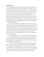
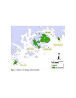
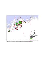
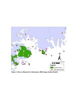
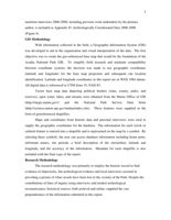
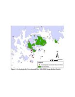
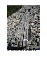
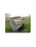
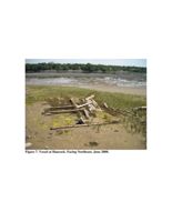
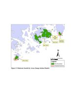
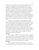
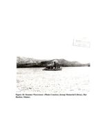
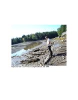


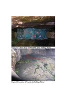
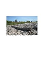


